Farewell Beacon..., The next cape beckons... |

  |
Farewell Beacon..., The next cape beckons... |
 Nov 26 2006, 03:58 AM Nov 26 2006, 03:58 AM
Post
#1
|
|
 Senior Member  Group: Members Posts: 1229 Joined: 24-December 05 From: The blue one in between the yellow and red ones. Member No.: 618 |
Wow! If I live to be a hundred, I'll never understand why we've sailed right on past the Beacon toward "Boat Ramp". I agree that the deepest exposures are the most important, but Beacon is the highest! It's sitting right there waiting for us. It's the top of the section. Whether it's composed of impact breccia or undisturbed laminated evaporite determines whether Victoria formed after or before the deposition of the upper Planitia Meridiani. I can't believe that is a trivial issue. It is a fundamental fact of Victoria's history.

-------------------- My Grandpa goes to Mars every day and all I get are these lousy T-shirts!
|
 |
 
|
|
Nov 26 2006, 06:59 AM
Post
#2
|
||
 The Poet Dude Group: Moderator Posts: 5551 Joined: 15-March 04 From: Kendal, Cumbria, UK Member No.: 60 |
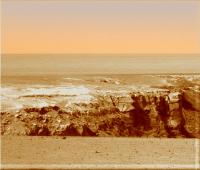
And so Oppy drives on, away from Beacon and towards the next Cape...
VERY interesting feature coming into view now, a tall "stack" of rock on the end of the next Cape, a kind of martian "Old Man of Hoy"...
Not an exact comparison, I know - the "Old Man of Hoy" stack is totally detached from its cliff - but the best I can do at 7am, 4 hrs before I leave for a week's holiday in Spain. So, have fun all, say hi to the next Cape for me, and I'll look forward to lots of gorgeous pans by you all of "Hoy" when I return... 
-------------------- |
|
|
|
|
|
|
Nov 26 2006, 08:02 AM
Post
#3
|
|
|
Senior Member Group: Moderator Posts: 4279 Joined: 19-April 05 From: .br at .es Member No.: 253 |
I'm wondering if they will name it another cape or actually consider as Cape St. Mary the whole structure the rover is now on.
> 4 hrs before I leave for a week's holiday in Spain. Enjoy it Stu! And I hope the weather would be better then the last few days (raining). I'm now 8h before I leave for a week's *work* in Germany. |
|
|
|
|
Nov 26 2006, 08:34 AM
Post
#4
|
||
|
The Poet Dude Group: Moderator Posts: 5551 Joined: 15-March 04 From: Kendal, Cumbria, UK Member No.: 60 |
QUOTE (Tesheiner @ Nov 26 2006, 08:02 AM)  I'm wondering if they will name it another cape or actually consider as Cape St. Mary the whole structure the rover is now on. It is a new Cape isn't it? Going by the latest map... Isn't "Hoy" on the end of the next Cape clockwise...?
-------------------- |
|
|
|
|
|
|
Nov 26 2006, 08:50 AM
Post
#5
|
|
|
Founder Group: Chairman Posts: 14432 Joined: 8-February 04 Member No.: 1 |
I would have thought they would drive to the other side of C St M first - to observe the outcrop on the near side of the next cape and THEN drive around the next bay onto that next cape from which to observe the northern outcrop of C St M and the Southern outcrop of the next Cape.
Enjoy Spain Stu Doug |
|
|
|
|
Nov 26 2006, 08:58 AM
Post
#6
|
|
|
Founder Group: Chairman Posts: 14432 Joined: 8-February 04 Member No.: 1 |
Without access to information such as TES or the MB and APXS work done recently, it is hard if not impossible to understand why they might or might not have done something you thought they should.
Doug |
|
|
|
|
Nov 26 2006, 09:19 AM
Post
#7
|
||
|
The Poet Dude Group: Moderator Posts: 5551 Joined: 15-March 04 From: Kendal, Cumbria, UK Member No.: 60 |
QUOTE (Stu @ Nov 26 2006, 08:34 AM) It is a new Cape isn't it? Going by the latest map... Isn't "Hoy" on the end of the next Cape clockwise...? Hmmm... I'm not sure now.... Just been looking at the navcams...
... and I feel a bit confused. If I look at it, I can almost convince myself that the "Hoy" feature does appear to be part of Cape St Mary... especially if that is the wide "ramp" over yonder, just over the shoulder of "Hoy"..? Oh well, I'm sure you'll have it figured out when I get back. Edit: no, I'm sticking with my original idea, I think it is a feature on "the next Cape" along. Going with first impression. Shutting up now.
-------------------- |
|
|
|
|
|
|
Nov 26 2006, 02:05 PM
Post
#8
|
||
|
Solar System Cartographer Group: Members Posts: 10151 Joined: 5-April 05 From: Canada Member No.: 227 |
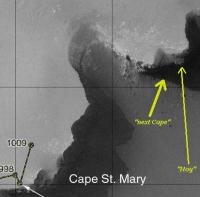
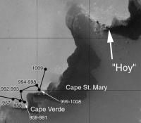
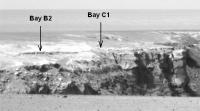
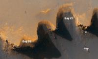
I think "Hoy" is here:
Phil -------------------- ... because the Solar System ain't gonna map itself.
Also to be found posting similar content on https://mastodon.social/@PhilStooke Maps for download (free PD: https://upload.wikimedia.org/wikipedia/comm...Cartography.pdf NOTE: everything created by me which I post on UMSF is considered to be in the public domain (NOT CC, public domain) |
|
|
|
|
|
|
Nov 26 2006, 02:13 PM
Post
#9
|
|
|
Member Group: Members Posts: 910 Joined: 4-September 06 From: Boston Member No.: 1102 |
-------------------- |
|
|
|
|
Nov 26 2006, 04:48 PM
Post
#10
|
|
|
Member Group: Members Posts: 240 Joined: 18-July 06 Member No.: 981 |
Hoy is more likely at the end of the c1-c2 cape. There are two capes in the image and a bay between them barely visible.
|
|
|
|
|
Nov 26 2006, 07:49 PM
Post
#11
|
|
|
Member Group: Members Posts: 477 Joined: 2-March 05 Member No.: 180 |
I hope they're careful - it looks like Opportunity's headed toward some prime spots for dust deposition.
|
|
|
|
|
Nov 26 2006, 09:31 PM
Post
#12
|
|
|
Senior Member Group: Members Posts: 3516 Joined: 4-November 05 From: North Wales Member No.: 542 |
QUOTE (MarkL @ Nov 26 2006, 04:48 PM) Hoy is more likely at the end of the c1-c2 cape. There are two capes in the image and a bay between them barely visible. It looks that way to me too. That would mean we're only seeing the top of the B cape cliffs so far and they go some way further down. The 'Old Man of Hoy' might just be the tallest vertical feature in Victoria. Unfortunately Magellan didn't sail past Orkney (or Cape Horn, which would have been an ideal official name). |
|
|
|
|
Nov 26 2006, 11:32 PM
Post
#13
|
|||
 Senior Member Group: Members Posts: 4246 Joined: 17-January 05 Member No.: 152 |
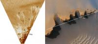
I agree with MarkL and ngunn. We're seeing things heavily foreshortened in that direction, so looking slightly to the right means seeing capes much farther away. Here's our and the orbital views matched up:
Bay B3 is completely hidden from view currently. |
||
|
|
|
||
|
Nov 27 2006, 02:29 AM
Post
#14
|
||
|
Solar System Cartographer Group: Members Posts: 10151 Joined: 5-April 05 From: Canada Member No.: 227 |
That's right. I didn't look far enough. Here's a comparison of the image at the top of this thread, after using the perspective tool in Photoshop, with the HIRISE image.
Phil
-------------------- ... because the Solar System ain't gonna map itself.
Also to be found posting similar content on https://mastodon.social/@PhilStooke Maps for download (free PD: https://upload.wikimedia.org/wikipedia/comm...Cartography.pdf NOTE: everything created by me which I post on UMSF is considered to be in the public domain (NOT CC, public domain) |
|
|
|
|
|
|
Nov 27 2006, 06:20 AM
Post
#15
|
|||
 Senior Member Group: Members Posts: 2228 Joined: 1-December 04 From: Marble Falls, Texas, USA Member No.: 116 |
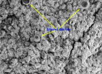
Shaka: I'll have to admit that I too was a bit surprised that they left the area so quickly, but it is true that they have a lot more spectral information on the rocks than we do at this point. I think we might be able to get a clue though, from the MIs taken of the RAT hole on Cape Verde. Granted, CSM is higher stratigraphically, but not that much. The MIs displayed several large berries embedded in the rock and shaved by the RAT. They are pretty confident in their model of these concretions having formed in sediment saturated by ground water, or what is usually called the phreatic zone. On the trip south Opportunity climbed stratigraphically and observed no berries and micro-berries at the highest points, which is consistent with that model.
The fact that they discovered large, embedded concretions in the rock here might suggest that these rocks came from the section that we have already seen. I must point out a serious flaw in this argument before someone else does. You would expect the surface rocks there to be ejecta, so they likely were derived from deeper layers. But now that I think about it, perhaps a better argument fro leaving would be that it appears that CSM is also mantled in ejecta, so what is the point of wasting time there? Better to move on and learn more about deeper, intact layers.
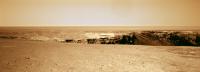
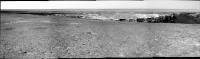
Jeff7: Some of us think those dark streaks were formed by the removal of light colored dust rather than dark dust deposition. So, it may be a good place to go for Opportunity's solar panels. I hope we can observe something on the soil as Opportunity passes bay B1, to allow us to determine whether the streaks are due to erosion or deposition. As long as I am going off topic, here is the drive direction panorama from sol 1009, as I was able to stitch it.
-------------------- ...Tom
I'm not a Space Fan, I'm a Space Exploration Enthusiast. |
||
|
|
|
||
|

|
Lo-Fi Version | Time is now: 25th April 2024 - 09:13 AM |
|
RULES AND GUIDELINES Please read the Forum Rules and Guidelines before posting. IMAGE COPYRIGHT |
OPINIONS AND MODERATION Opinions expressed on UnmannedSpaceflight.com are those of the individual posters and do not necessarily reflect the opinions of UnmannedSpaceflight.com or The Planetary Society. The all-volunteer UnmannedSpaceflight.com moderation team is wholly independent of The Planetary Society. The Planetary Society has no influence over decisions made by the UnmannedSpaceflight.com moderators. |
SUPPORT THE FORUM Unmannedspaceflight.com is funded by the Planetary Society. Please consider supporting our work and many other projects by donating to the Society or becoming a member. |
|