Spring at Cape York, Sol 2947 (after Greeley Haven) - sol 3040 |

  |
Spring at Cape York, Sol 2947 (after Greeley Haven) - sol 3040 |
 Aug 3 2012, 05:06 PM Aug 3 2012, 05:06 PM
Post
#466
|
|
|
Member  Group: Admin Posts: 976 Joined: 29-September 06 From: Pasadena, CA - USA Member No.: 1200 |
QUOTE (mhoward @ Aug 3 2012, 09:15 AM)  Wow, Paolo, for being so data-constrained, you guys seem pretty serious about taking this Whim Creek mosaic.  Adding: and I'm glad you are; well, whoever is driving Opportunity now. At the moment Oppy has only downlink through ODY sitting still. The drivers now are: Khaled Ali, Tara Estlin, Julie Townsend (lead RP), and Ashley Stroupe. Paolo -------------------- Disclaimer: all opinions, ideas and information included here are my own,and should not be intended to represent opinion or policy of my employer.
|
 |
 
|
|
Aug 3 2012, 06:08 PM
Post
#467
|
|
 Senior Member Group: Admin Posts: 4763 Joined: 15-March 05 From: Glendale, AZ Member No.: 197 |
QUOTE (CosmicRocker @ Aug 2 2012, 10:12 PM) Since the sediments thin to nothing as they approach Cape York, the Whim Creek structure fades away as it approaches the cape. This observation seems to suggest that the fractures forming the structure do not extend down into the older rocks of Cape York. My fortune for a shovel. I'd love to have a look at the base rock under the collapsed rubble here. Hopefully Opportunity will traverse the length of the formation and maybe even try a wheel scuff at the apex. -------------------- If Occam had heard my theory, things would be very different now.
|
|
|
|
|
Aug 3 2012, 06:31 PM
Post
#468
|
|
 Senior Member Group: Members Posts: 4246 Joined: 17-January 05 Member No.: 152 |
QUOTE (RoverDriver @ Aug 1 2012, 11:43 AM) The fact that the JPL logo is highlighted by the Sun, that is totally a coincidence This reminds me, Paolo, of something I've wondered about. We often see regions of hazcam images, and nav/pancam shots of the ground close to the rover, with areas shadowed by parts of the rover. When images were planned, did you ever do any modelling or calculations (or even use educated guesses) to estimate where shadows will fall? Or do the other constraints on timing rover activity always take precedence? With the public jpegs, it can be hard to pull detail out of those shadowed regions, but of course you can do better with the original 10 bit images. Did you ever need to retake an image under better lighting conditions? |
|
|
|
|
Aug 3 2012, 06:44 PM
Post
#469
|
|
|
Member Group: Admin Posts: 976 Joined: 29-September 06 From: Pasadena, CA - USA Member No.: 1200 |
QUOTE (fredk @ Aug 3 2012, 11:31 AM) This reminds me, Paolo, of something I've wondered about. We often see regions of hazcam images, and nav/pancam shots of the ground close to the rover, with areas shadowed by parts of the rover. When images were planned, did you ever do any modelling or calculations (or even use educated guesses) to estimate where shadows will fall? Or do the other constraints on timing rover activity always take precedence? With the public jpegs, it can be hard to pull detail out of those shadowed regions, but of course you can do better with the original 10 bit images. Did you ever need to retake an image under better lighting conditions? This an excellent question. Our simulation tools do allow to predict the shadowing at any specific Sol and time. There are some circumstances where the shadows are taken into account. Usually we try to avoid having MI images part in shadow and part in direct sunlight as this will make it difficult, if not impossible, to get details out of one region. Sometimes there are things we can do to mitigate this issue (like moving the time when these images are taken, or use one IDD configuration vs another one) sometimes we cannot. Regarding Hazcams I alwas try(ed) to increas the number of bits per pixel for the HAZ that will be partly in shadow. There we are usually limited by the downlink and you have to pick and chose between having more detail in the HAZ or having potentially one more frame in the NAVCAM or PANCAM. It is always a trade between quality and quantity. If I have reasons to worry about the state of the wheels at the end of the drive then I bump up the bps request. I don't ever recall using a different vehicle heading during a drive to avoid shadowing, but we did select particular headings to image features. For example, Sao Gabriel (I think) was done mid-drive and I did select a particular rover heading during the mid drive to avoid having the back of the rover to clutter the image. For NAVCAM we also did move the time of image capture to have a better lighting, but that was a rare occurrence. Paolo -------------------- Disclaimer: all opinions, ideas and information included here are my own,and should not be intended to represent opinion or policy of my employer.
|
|
|
|
|
Aug 3 2012, 07:10 PM
Post
#470
|
||
|
Senior Member Group: Members Posts: 2819 Joined: 22-April 05 From: Ridderkerk, Netherlands Member No.: 353 |
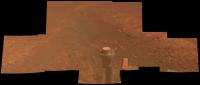
Sol 3029 and 3031 Panoramic view.
Jan van Driel
|
|
|
|
|
|
|
Aug 4 2012, 01:45 AM
Post
#471
|
||
 Member Group: Members Posts: 691 Joined: 21-December 07 From: Clatskanie, Oregon Member No.: 3988 |
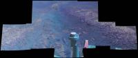
Added the images for Sol-3031.
|
|
|
|
|
|
|
Aug 4 2012, 01:49 AM
Post
#472
|
||
|
Member Group: Members Posts: 691 Joined: 21-December 07 From: Clatskanie, Oregon Member No.: 3988 |
And the false color of this sofar...
|
|
|
|
|
|
|
Aug 4 2012, 05:04 AM
Post
#473
|
||
|
Member Group: Members Posts: 691 Joined: 21-December 07 From: Clatskanie, Oregon Member No.: 3988 |
The Sol-3024 Navcam panorama from our current position.

|
|
|
|
|
|
|
Aug 4 2012, 06:50 AM
Post
#474
|
|||
 Senior Member Group: Admin Posts: 3108 Joined: 21-December 05 From: Canberra, Australia Member No.: 615 |
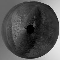
Two polar projections...
|
||
|
|
|
||
|
Aug 4 2012, 04:17 PM
Post
#475
|
|
|
Senior Member Group: Members Posts: 4246 Joined: 17-January 05 Member No.: 152 |
QUOTE (RoverDriver @ Aug 3 2012, 06:44 PM) Our simulation tools do allow to predict the shadowing at any specific Sol and time. Thanks as always for the fascinating explanations, Paolo!The latest Planetary update is up. One odd comment that's got to be a typo: QUOTE MARCI... began observing a dust storm near Endeavour Crater on July 13th... [It] came as close as 360 meters (0.22 of a mile) of Opportunity mid-month, but neither it, nor the one that followed 12 days later, hit the rover's immediate site and both dissipated quickly. There's no way MARCI could resolve the edge of a dust storm sharply enough to be able to say it was 360 m from Oppy! The edge is probably much more diffuse than that in the first place. My guess is they meant 360 km.
|
|
|
|
|
Aug 4 2012, 09:20 PM
Post
#476
|
||
 Member Group: Members Posts: 656 Joined: 20-April 05 From: League City, Texas Member No.: 285 |
QUOTE (jvandriel @ Aug 3 2012, 01:10 PM)
Is the color asymmetry real, or an artifact of lighting? It looks like different materials on either side of Whim. |
|
|
|
|
|
|
Aug 4 2012, 09:28 PM
Post
#477
|
|
|
Member Group: Members Posts: 154 Joined: 21-April 05 From: Rochester, New York, USA Member No.: 336 |
Gives me the impression of moss, especially the greener version.
|
|
|
|
|
Aug 4 2012, 09:52 PM
Post
#478
|
|
|
Merciless Robot Group: Admin Posts: 8783 Joined: 8-December 05 From: Los Angeles Member No.: 602 |
But it's false color, and it's most definitely not.
-------------------- A few will take this knowledge and use this power of a dream realized as a force for change, an impetus for further discovery to make less ancient dreams real.
|
|
|
|
|
Aug 4 2012, 10:09 PM
Post
#479
|
|
|
Senior Member Group: Members Posts: 4246 Joined: 17-January 05 Member No.: 152 |
QUOTE (algorimancer @ Aug 4 2012, 09:20 PM) Is the color asymmetry real, or an artifact of lighting? It looks like different materials on either side of Whim. Lighting may be a factor. Also wind may deposit materials preferentially on one side of the crick. |
|
|
|
|
Aug 5 2012, 12:47 AM
Post
#480
|
||
 The Poet Dude Group: Moderator Posts: 5551 Joined: 15-March 04 From: Kendal, Cumbria, UK Member No.: 60 |
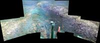
Think I've *finally* got the colour balance right(ish) on the Whim Creek pan - that (insert expletive here) green gravel on the left is now grey-blue, at last...
Work in progress...
-------------------- |
|
|
|
|
|
|

|
Lo-Fi Version | Time is now: 24th April 2024 - 01:38 AM |
|
RULES AND GUIDELINES Please read the Forum Rules and Guidelines before posting. IMAGE COPYRIGHT |
OPINIONS AND MODERATION Opinions expressed on UnmannedSpaceflight.com are those of the individual posters and do not necessarily reflect the opinions of UnmannedSpaceflight.com or The Planetary Society. The all-volunteer UnmannedSpaceflight.com moderation team is wholly independent of The Planetary Society. The Planetary Society has no influence over decisions made by the UnmannedSpaceflight.com moderators. |
SUPPORT THE FORUM Unmannedspaceflight.com is funded by the Planetary Society. Please consider supporting our work and many other projects by donating to the Society or becoming a member. |
|