Printable Version of Topic
Click here to view this topic in its original format
Unmanned Spaceflight.com _ Opportunity _ Getting to 'Big Crater'
Posted by: SFJCody Sep 21 2006, 11:57 AM
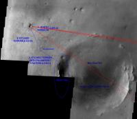
Opportunity is not quite at Victoria yet, but on the horizon is a tantalising goal for the future- the big eroded crater to the south-east, the rim of which is already visible. This is the first 'large scale' topography of the mission so far. Wouldn't it be great if Opportunity could get to these hills and uncover their secrets?
http://homepage.ntlworld.com/sfjcody2/route_to_big.jpg
Posted by: Castor Sep 21 2006, 12:04 PM
I agree that exploring the West Rim of Big Crater would be absolutely amazing, but having seen the first glimpse of Victoria I think that we are going to be here for a very long time. There looks to be enough geology here at VC to keep Opportunity occupied for a year (Earth or Martian!) or more.
Castor
Posted by: Bill Harris Sep 21 2006, 12:14 PM
Actually, the "Leg B of the etched terrain" might be feasible unless Oppy gets bogged down in Victoria. That would get us stratigraphically lower and would make for good science but not photo-ops.
--Bill
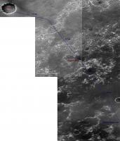
Posted by: ustrax Sep 21 2006, 12:40 PM
And I was hesitating on starting talking about this... 
Beyond!:
http://i16.photobucket.com/albums/b14/ustrax3/beyondvictoria.jpg

EDITED: And for what I'm seing that 'Big Crater' doesn't have a name...yet... 
Posted by: algorimancer Sep 21 2006, 12:52 PM

http://homepage.ntlworld.com/sfjcody2/route_to_big.jpg
Really nice picture by the way, not sure that I'd seen this one before.
Could those be fossil shorelines in the interior of that big crater? Bearing in mind how wet it's been in Meridiani, I find that easily conceivable.
Prior to committing to a Big Crater campaign, however, I'd want to fill-in the imagery to the southwest. Seems like I recall seeing some interesting dendritic channel terrain off in that direction, as well as some unique topography. The driving conditions off towards Big Crater look pretty boring.
Posted by: djellison Sep 21 2006, 12:58 PM
For the love of god don't let a rover driver see this or we'll be attempting to jump Victoria in the rush to get there 
Doug
Posted by: ustrax Sep 21 2006, 01:09 PM
Doug
Tempting ain't it?...
Troy will be ours!

And we got the only horse that fits for the journey...
http://i16.photobucket.com/albums/b14/ustrax3/troy.jpg
Man...I'm dizzy...

Posted by: SFJCody Sep 21 2006, 01:19 PM
It's based on a THEMIS mosaic I found on the forums, can't remember who made it but thanks whoever you are!
I think the thing to do is to plaster the terrain between Victoria and 'Big Crater' with HIRISE images to determine the most suitable route.
Posted by: Nix Sep 21 2006, 01:25 PM
That horizon looks like the one I posted in the mosaic with the synthetic sky...do not rely on the accuracy too much except for the obvious hills marking the rim of the far crater.
The real horizon is more straight and I'm not sure about 'B' ...
Maybe I'll give that horizon another go but honestly, for the moment, I don't give a rat's a** what's beyond Victoria, it's been a long way and I want to see this crater inside out
Nico
Posted by: ustrax Sep 21 2006, 01:42 PM
Yes, the original image was yours Nico
Posted by: climber Sep 21 2006, 03:33 PM
Troy will be ours!
And we got the only horse that fits for the journey...
http://i16.photobucket.com/albums/b14/ustrax3/troy.jpg
Man...I'm dizzy...
When we'll be on this promontory on the left, we'll have another perspective of "Troy" from which you'll be able to play around and find new/ confirm structures. I'm sure, we'll have to think about what's behind the horizon once Oppy will be inside VC. I'm sure will get bored sometimes during VC exploration so we'll revive this thread.

Posted by: mhoward Sep 21 2006, 03:56 PM
Man...I'm dizzy...
So that's what the horizon feature is. I didn't believe it could be that clear from so far away, but it is. Far out.
Since it is so clear, is there any remote science we can do on it from this far away? Would mini-TES tell us anything useful? 'Cause I reckon it's going to be a long time before we get much closer. I think we will be at Victoria for at least a year (Earth or Mars). If Oppy lives forever, maybe we will someday see 'Troy' up close.
Posted by: tim53 Sep 21 2006, 04:34 PM
http://homepage.ntlworld.com/sfjcody2/route_to_big.jpg
It would indeed be nice to be able to explore that crater, but we need to remember the condition of the rover at present, the fact that it's way "out of waranty" at this time, and that it will likely take the better part of a year to explore Victoria in sufficient detail.
It is the project's policy to name craters only as we visit them, and the names used are project-specific - not IAU approved. That crater is 22 kilometers in diameter, and based on the IAU convention for naming craters on Mars would be named after a city on Earth with a population under 100,000. Craters greater than 100 kilometers in diameter are named after famous scientists, at least 3 years after their passing.
The view, though, is quite glorious from here! Wait until we get to the rim!
planetarily,
-Tim.
Posted by: ustrax Sep 21 2006, 04:39 PM
So...Victoria shouldn't bear a city's name?
Troy was a city...Wasn't it?...
And yes...Reaching one of the promontories it will be a hell of a view we will be previliged to contemplate...
EDITED: Just called it Troy because, at this distance, it would be a mythical battle to get there and to find a tricky way for our horse to penetrate the "city's walls" and contemplate Helen's beauty...
Well...Just foreseing all of us departing Greece and sailing all the way there.
Posted by: climber Sep 21 2006, 04:40 PM
-Tim.
So, "UMSF" will be OK : it's a city under 100,000
Posted by: Ant103 Sep 21 2006, 04:45 PM
This thread remember me an other thread I made a time ago
http://www.unmannedspaceflight.com/index.php?showtopic=2327
Posted by: ustrax Sep 21 2006, 04:45 PM

aka the proud and glorious Geeksville!
Posted by: ElkGroveDan Sep 21 2006, 05:51 PM
Well "http://www.census.gov/Press-Release/www/releases/archives/population/007001.html" is out as of about 2 years ago. I once lived in Bozeman, MT though. That has a nice ring to it. I'll start my naming campaign as soon as we are finished with Victoria.

Posted by: imipak Sep 21 2006, 08:12 PM
Mad, mad, mad... you're all completely mad. I love it!
Looking at the large-scale image I thought: those knife-sharp rim hills would look sensational from the north with a low light angle, at dawn or sunset. Hmmm... I wonder how wide that ridgeline really is?
Now... imagine - if you dare - the view from the top of Priam...

Posted by: tim53 Sep 21 2006, 08:47 PM
So...Victoria shouldn't bear a city's name?
It doesn't.
...you guys know that, don't you?
-Tim.
Posted by: Jeff7 Sep 21 2006, 09:30 PM
Beyond!:
http://i16.photobucket.com/albums/b14/ustrax3/beyondvictoria.jpg
EDITED: And for what I'm seing that 'Big Crater' doesn't have a name...yet...
Time to start a poll for the arrival at Big Crater. Let's see, I'll give maybe 400 sols to Victoria if we hurry. So that'll be somewhere around Sol 1350 for departure. It took almost 900 Sols to explore Endurance and then get to Victoria, minus some time at Purgatory. Assuming 1 stopoff at MiniEndurance, and only 100 Sols there.....let me see here.
Leave Sol 1350. Drive days, lots of drive days. No science. 400 days to get to MiniEndurance, Sol 1750. 100 Sols of exploration. 1850. Another 400 to get to Big Crater. 2250.
Add in times for getting stuck, and more time for science stops that really should be made. Maybe push Sol 2500. Plus possible wheel problems similar to Spirit's, Sol 3000.
While I'd love to see it happen, I think that that's pushing it a little.
Posted by: slinted Sep 21 2006, 09:35 PM
You're welcome
Here's the original mosaic, if anyone else wants to play with it.
http://www.lyle.org/~markoff/collections/meridiani_themis.jpg
Posted by: climber Sep 21 2006, 09:49 PM
Leave Sol 1350. Drive days, lots of drive days. No science. 400 days to get to MiniEndurance, Sol 1750. 100 Sols of exploration. 1850. Another 400 to get to Big Crater. 2250.
Add in times for getting stuck, and more time for science stops that really should be made. Maybe push Sol 2500. Plus possible wheel problems similar to Spirit's, Sol 3000.
While I'd love to see it happen, I think that that's pushing it a little.
What'll be the definition of arrival then
? The crater is so big!Anyway, by Sol 3000, MSL will be already there
Posted by: climber Sep 21 2006, 09:57 PM
Here's the original mosaic, if anyone else wants to play with it.
Whao!
If Endurance is the crater on the uper left and VC on the South of it (in this case I can also see Erebus) we've already have roved half the distance it'll take to get to the first descent big hill.
I just realise it's just NOT impossible
May be one day Oppy will just do what Spirit did : climb a Hill. Umbelievable!!!!
Posted by: djellison Sep 21 2006, 10:13 PM
We've covered just under half the distance to the endurance scale crater between here and 'Big Crater' - in terms of getting to Big Crater - we've covered abotu 30% of the distance required.
Doug
Posted by: jamescanvin Sep 21 2006, 11:33 PM
Troy will be ours!
And we got the only horse that fits for the journey...
http://i16.photobucket.com/albums/b14/ustrax3/troy.jpg
Man...I'm dizzy...
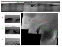
Nice diagram Ustrax, a shame it's fiction!
For two reasons - First, most of those features can't be seen in the original images - they are artifacts of Nico's processing. I can only see B, C & F
Here are some 5x vertical + contrast/brightness of the raw 943 pancams:

|

|

|

|
Second, The headings to those features are all wrong, here are the headings of the edges of the three features marked on the themis image.
|
As you can see B & C are the "Twin Peaks" on the north rim of the crater that we have been able to see for a while. As in my earlier work, the only thing in the direction of "F" is the far rim - It's a long way, but nowhere near as far as the Gusev rim is from Spirit so there is no reason why we shouldn't be able to see that far.
As we've found with the MOC images, sometimes the headings don't quite line up over large distances - I've marked (in light blue) the bit of the rim just offset from the derived heading that looks higher and what I consider to be the best candidate for "F"
James
Posted by: MahFL Sep 21 2006, 11:59 PM
Can anyone tell if the rim is higher than the Columbia Hills ?
Posted by: jamescanvin Sep 22 2006, 12:29 AM
If you look at the image I posted back here - http://www.unmannedspaceflight.com/index.php?s=&showtopic=3056&view=findpost&p=66855
It's hard to read - but it looks like some of the far rim peaks could be 150+m above the surrounding plains so yes, bigger than the Columbia hills. (And maybe 600-700m above the crater floor!)
Posted by: clt510 Sep 22 2006, 04:55 AM
Are you trying to start another near-rim far-rim argument?
Posted by: djellison Sep 22 2006, 07:02 AM
Oh we've got to stop this I'm getting excited about the sort of view we could have from there - and that's bad because I really can't imagine us getting there, realistically.
Doug
Posted by: Nix Sep 22 2006, 07:17 AM
Me n'either, it's just too far. I might believe in it if ;
a - Victoria wasn't waiting here for us
b - The road up there is smooth all the way
Nico
Posted by: SFJCody Sep 22 2006, 07:37 AM
I don't really believe it either, but if Opportunity ever gets to the point where it can be said to have 'done' Victoria crater, and if it is still mobile at that point, and if it's not trapped in the crater it would probably be worthwhile to extend the 'baseline' for measurements of horizontal compositional variation in the Meridiani bedrock by driving a long distance south-east (more or less the opposite direction from Eagle crater). Which just happens to be the direction of 'big crater'...
Posted by: ugordan Sep 22 2006, 07:56 AM
That's a BIG IF, if you ask me. I dunno, that V thing looks really steep, one has to wonder if Oppy'll be able to safely get in there in the first place!
Posted by: climber Sep 22 2006, 08:14 AM
So far, in Meridianii we only know (or search) "under" the plain. If we can climb this hill, we'll have what we're missing : a view "above" the plain and we'll may be see how deep the standing water has been. This must definately be a goal for MRO...in case Oppy will not reach the hills
Once again, take the distance from Eagle to Vicky, double this i.e about 15km, and you're at the hill. Not "that" far away.
Posted by: ugordan Sep 22 2006, 08:31 AM
Yeah, but consider how many more months/years that is. Is it really realistic to expect Oppy to live that long? While she's maybe getting smarter with time, she's certainly not getting any younger.
Posted by: SFJCody Sep 22 2006, 08:42 AM
One more reason to be interested in going to this place: the rim of Big Crater (certainly the eastern rim, probably also the western rim, although it's hard to tell at this resolution) is not coated in blueberries- there's no hematite signal there! Whatever kind of bedrock it's made of is not the kind Oppy has seen to date...
http://photojournal.jpl.nasa.gov/jpeg/PIA05154.jpg
Posted by: Stephen Sep 22 2006, 08:45 AM
I'm getting excited about the sort of view we could have from there - and that's bad because I really can't imagine us getting there, realistically.Doug
On the other hand, way back at Sol 1, or even Sol 90, would any of us have anticipated, realistically, that Opportunity would get as far as Victoria? Even the etched terrain seemed a long way of back thenl
If and when Opportunity leaves the Victoria it and the MER team (not to mention us!) will need another goal, and right now "Big Crater" seems no more impossible now that Victoria Crater was as a destination all those Sols ago.
======
Stephen
Posted by: djellison Sep 22 2006, 08:49 AM
Once we had left Endurance - yes - realistically I thought that Victoria, if the terrain was navigable, was a genuine possibility.
However - looking SE from Victoria - I don't like the look of the terrain a great deal - there's no MOC NA imagery that I can see in that direction and we need that or HiRISE to judge what the navigability would be like.
Realistically - I think we could spend at least the next 300-500 sols exploring Victoria - THEN....let's see how the rover is doing.
Doug
Posted by: ustrax Sep 22 2006, 09:02 AM
I just got blinded with Helen's beauty...
Now we're getting somewhere with your great work James!
Another implication, besides Oppy becoming a granny faster and faster, would be the funding for the time needed to perform such a saga...but hey! Who knows?
EDITED: We can work this a bit more...
James, I made a new version taking in account some of your directions and others...not so quite...
From the features marked what are those we can say, with no doubt at all, that are misplaced or are, truly, artifacts?:
http://i16.photobucket.com/albums/b14/ustrax3/troy2.jpg
Posted by: Stephen Sep 22 2006, 10:29 AM
It's enough to make you wonder how terrestrial explorers of a non-mechanised kind ever managed to find their way around Earth before the advent of satellite imagery...
Having the MOC images has been nice (especially for Tesheiner's maps), but let's face it: they're a basically a luxury. They didn't stop Opportunity getting stuck at Purgatory and they were of limited use in determining--beforehand--what the actual nature of the etched terrain was like. They doubtless helped the Opportunity route planners attempt those long drives after Endurance, but the terrain itself soon spelt an end to those, imagery or no imagery. After that the rover and its planners more or less had to feel their way forward anyway. Only now that it has reached Victoria's annulus have the long drives resumed; and that has arguably had less to do with the orbital imagery than the flatness of the terrain evident to the rover's own eyes.
If the rover has the opportunity--pardon the pun
--to strike out into the martian equivalent of Terra Incognita, why not? It will not be as if it will be venturing out there entirely blind. The rovers do have their own eyes, after all. If it--or at least its drivers--get a little lost and have to backtrack a little (or maybe a lot, depending on the terrain), so what? As everybody, from Steve Squyres down, keeps reminding us: the rovers are into extra time now. It's not as if they are trying to beat some kind of deadline (as they were back in their first 90 days). Opportunity in particular is on what Hollywood would probably term a "road trip"; and with those the journey and what you learn along the way can sometimes be at least as important as getting to the desired destination.Of course. Victoria first.
But that said like others I'm beginning to have doubts about whether the rover will actually be able to get inside Victoria--short of rolling off a clifftop.
 And even then it may well find no bedrock to land on, just a slope of scree descending steeply to the dunefield on the crater floor.
Still, time will tell.
======
Stephen
Posted by: ustrax Sep 22 2006, 10:39 AM
--to strike out into the martian equivalent of Terra Incognita, why not?Great reading Stephen!
We are starting to dream of that crater beyond and I love the way that sounds...
As imipak wisely said...: "Mad, mad, mad... you're all completely mad. I love it!"
Posted by: Stephen Sep 22 2006, 10:42 AM
Now we're getting somewhere with your great work James!
Another implication, besides Oppy becoming a granny faster and faster, would be the funding for the time needed to perform such a saga...but hey! Who knows?
EDITED: We can work this a bit more...
James, I made a new version taking in account some of your directions and others...not so quite...
From the features marked what are those we can say, with no doubt at all, that are misplaced or are, truly, artifacts?:
http://i16.photobucket.com/albums/b14/ustrax3/troy2.jpg
Two points.
1) You left out F & G. I suggest F == Cassandra and G == Hector.
2) That should be "Ulysses" not "Ulisses". However, "Ulysses" was actually the Latin version of the Greek name "Odysseus". "Odysseus" is where the word "odyssey" comes from, a term that seems not inappropriate, I think, to be associated with Opportunity's trek.
======
Stephen
Posted by: ustrax Sep 22 2006, 11:13 AM
1) You left out F & G. I suggest F == Cassandra and G == Hector.
2) That should be "Ulysses" not "Ulisses". However, "Ulysses" was actually the Latin version of the Greek name "Odysseus". "Odysseus" is where the word "odyssey" comes from, a term that seems not inappropriate, I think, to be associated with Opportunity's trek.
======
Stephen
You're right, I've posted a wrong version...I corrected and used your suggestion trying to follow the legend's narrative:
So now we have:
http://i16.photobucket.com/albums/b14/ustrax3/troy3b.jpg
Agamemnon (I've seen his supposed death mask in Athens...Hypnotizing...) and his fleet (A) chasing Paris and Helen (
, on the right we have Priam the King (H) as the tallest peak, with his descendance aside, Cassandra (G) and Hector (F) on the left the one who killed him, Achilles (E)Only Ulysses (D) is a bit misplaced...We have to study that...
(Ulisses is the Portuguese way of writing it...)
Posted by: climber Sep 22 2006, 11:32 AM
Y?
Posted by: odave Sep 22 2006, 12:35 PM
Hey, http://en.wikipedia.org/wiki/Troy,_Michigan works!
Hmm...Google, Google
Darn. http://www.roving-mouse.com/planetary/Mars/Atlas/feature-index.html (look under "T")
Posted by: Phil Stooke Sep 22 2006, 12:36 PM
SFJCody said "One more reason to be interested in going to this place: the rim of Big Crater (certainly the eastern rim, probably also the western rim, although it's hard to tell at this resolution) is not coated in blueberries- there's no hematite signal there!"
I think that is just a data gap in the hematite colour overlay on the background image. There are others, showing as grey windows in the colour. The rim one appears more prominent because the rim itself is so contrasty.
Phil
Posted by: SFJCody Sep 22 2006, 12:58 PM
Phil
There are data gaps, yes, but most of them appear as linear streaks that have no relation to the surrounding areas. If you look at the three big craters in a row (the eroded one being at the top) you'll see that each one is surrounded by a 'halo' of green-blue (indicating a weak signal) that conforms to the shape of the rim. The smaller middle crater has quite a big 'halo' for its size, and this may be because it has a noticeable ejecta blanket overlying the terrain. It's the same (but more pronounced) with the really big fresh crater to the south west- the crater and the ejecta blanket shows no signal, and the outskirts are green-blue.
Posted by: ugordan Sep 22 2006, 01:18 PM
I'm with Phil on the data gap thought. While the big ejecta around the bottom-left crater is obviously devoid of hematite, the area in the "Big Crater" walls "lacking" hematite seems suspiciously coincident with the parts with greatest illumination/reflectance. It might well be instrument saturation occured there (this could be a ratio image used as color overlay) and no useful data exists for those spots.
Posted by: climber Sep 22 2006, 01:22 PM
Can we deduce crater's ages and/or water depth with those data? I mean age in comparison of hematite formation and depth by followinh hematire signal around the craters.
Posted by: SFJCody Sep 22 2006, 01:27 PM
How would instrument saturation account for the low-hematite green-blue 'halos' (particularly for the case of the smaller middle crater with the ejecta blanket) which cover what appears to be low-reflectance terrain?
Posted by: ustrax Sep 22 2006, 02:39 PM
Indeed... That lead us to another hypothesis that even pleases me more...
Ithaca Crater!
At a same time the home of Ulysses/Odysseus, and an hommage to all the brains coming out from Cornell University in Ithaca (population: 29287)...
We have to remind that Ulysses returned to Ithaca...Will Opportunity make it?...
Posted by: ElkGroveDan Sep 22 2006, 03:00 PM
You'll be glad to know that I heard a rumor how they are out at the JPL test bed right now practicing "rover rolls". The goal is to see exactly how to approach a ledge and roll off of it so that the rover lands upright after three or four tumbles. I hear it's not going well but it's really fun to watch.......
(joking, just joking)
Posted by: Pavel Sep 22 2006, 03:22 PM
Indeed... That lead us to another hypothesis that even pleases me more...
Ithaca Crater!
At a same time the home of Ulysses/Odysseus, and an hommage to all the brains coming out from Cornell University in Ithaca (population: 29287)...
We have to remind that Ulysses never returned to Ithaca...Will Opportunity make it?...
I second that. Actually, I was going to propose the same name! I'm shocked. You must have read my thoughts.
One more reason for http://en.wikipedia.org/wiki/Ithaca%2C_NY. There are many interesting geological features around, and also many waterfalls, including http://www.taughannock.com/, which is higher than Niagara falls. That fits well with the goals of the MER mission - study the geology and the role of water.
Posted by: ustrax Sep 22 2006, 03:24 PM
Dream! Dream! Dream!
I'm already answering to myself...
But, as in other occasions provided by this two little wanderers, something magical happens from time to time...
We are reaching Victoria and Oppy will be there for a long time, but somehow some of us feel that she won't end up there. I do. And this poem...http://i16.photobucket.com/albums/b14/ustrax3/ithaca1.jpg...
http://www.translatum.gr/poetry/cavafy.htm
EDITED: Pavel, it would be a great place to end this Odyssey wouldn't it?...
Posted by: Marz Sep 22 2006, 04:08 PM
Wow, this thread is zuper nuts! We're talking about 8-10km drive?
This may not be totally unreasonable, especially if the science return is low because the arm craps out during the Victoria campaign. Sadly, if this were the case, there would be fewer reasons to stop n' sniff, and perhaps a more aggressive drive campaign. If the terrain is favorable, we might get up to 80m drives again... placing the West Rim in reach before the onset of next winter, depending on how much time is spent at Victoria.
Then again, I had dreamed of Spirit exploring the Chaos terrain... which is gonna be quite a stretch for her to pull that off.
This really makes me wonder what the MSL mission will be like. That could cover some serious ground!
Posted by: ustrax Sep 22 2006, 04:17 PM
Personally I've re-read already several times and I got severe cramps on my belly...
From Doug's "For the love of god" to climber's UMSF city..."Mad, mad, mad...I'm loving it"
It's truly a strong candidate for the forum Zuper Nuts Award 2006...And who knows 2007, 2008,...
Posted by: tim53 Sep 22 2006, 05:15 PM
Um... ...12 kilometers, PAST Victoria, so from the southeast side of Victoria. And that's to the degraded rim (rimless). The north rim peaks are 22 kilometers away, and stick up about 80-100 meters above the local plains. The southeast rim peaks are 35 kilmeters away, and taller (though I don't have my topomap open at the moment).
If the shoulder joint fails while the arm is deployed, it will be impossible to completely stow the arm, so it will be in the field of view of the navcams and bouncing around a bit while driving, so the distances we'll be able to cover will be MUCH less than with the arm stowed.
There is a difference between planning on GETTING all that way versus driving in that direction to cover new ground. I don't think many of us expected we'd make it all the way to Victoria with Oppy, and yet here we are. Spirit may not be able to move far in a sol, but it may be able to move. And who knows how far it may go before something else breaks? Worth a try.
-Tim.
Posted by: Pavel Sep 22 2006, 05:43 PM
End? Never!
By the time we are there, we'll have another big crater in sight, perhaps the "big splat" further south.
An the software will be updated again allowing Oppy to chase dust devils on its own for the purpose of cleaning
Posted by: ustrax Sep 22 2006, 05:52 PM
One thing at a time...
12kms?...Do you guys have anything planned for 2009' Autumn?...
Posted by: tim53 Sep 22 2006, 06:23 PM
12kms?...Do you guys have anything planned for 2009' Autumn?...
Yeah! Launching MSL!
-Tim.
Posted by: climber Sep 22 2006, 10:33 PM
-Tim.
Good answer Newbie-Senior member
How can this be ?
Posted by: jamescanvin Sep 22 2006, 10:58 PM
Because Doug says so!
Ustrax: Going back to your feature matching. I still think most of the features are fictitious, I really would advise going back to the 'raw' images.
Re B&C, the 'twin peaks', some guys here have been tracking those since way back, I think there is no doubt that it is part of the north rim complex, your 'A' on the Themis image.
I think this topic will be better adressed when we have some L7 which should be much better quality for distant features.
James
Posted by: Pando Sep 22 2006, 11:25 PM
How can this be ? Sometimes it just cracks me up seeing "newbie" on Tim Parker's user profile....
Posted by: Bobby Sep 23 2006, 01:18 AM
Now what are the overall odds of Oppy Getting to The Big Crater called ustrax abyss #3?
I would say 10 % odds that Oppy will get there if they don't fall into Victoria ustrax abyss #2
Posted by: 1101001 Sep 23 2006, 01:25 AM
(joking, just joking)A good joke, no so very far from reality.
Did any of you rover fans see test footage of the rover dismounting the lander back before they decided ramps were a good idea? It was on the web a long time ago, some NASA site, maybe while the rovers were cruising to Mars, or maybe shortly after landing. I've looked for it since but failed to find it. If anyone knows its whereabouts, please let us know. It's a fun watch.
OK. No ramp. The rover needed to get off the lander platform and onto the ground, a foot or two down. It rolled right to the edge of the platform, kept rolling so the front wheels were in space, kept rolling on 4 wheels, and the entire craft began to rotate -- gasp! -- until the rover body was almost vertical, until the front wheels touched down. Then it rolled some more and the middle wheels left the platform and reached the ground, and finally the rear wheels: 6 wheels on the ground. It was scary -- and it was only a test vehicle.
Yeah. I'm glad they eventually went with the ramps. But, it was good to know what kind of a vertical step a rover could handle if it had to.
Anyone else see it? Know where it is?
Posted by: Oren Iishi Sep 23 2006, 02:19 PM
I would say 10 % odds that Oppy will get there if they don't fall into Victoria ustrax abyss #2
I didn't see the footage your talking about, but on a similar theme, is anyone else a little nervous that new driving software is being implemented as the rover approaches the egde of the crater. I would think they might try it while the rover is navigating the plains not on the edge of a cliff. If Oppy falls to her doom into Victoria beacause of the new software, NASA will have wiped out all of the good will this mission has received and face a PR nightmare.
Posted by: climber Sep 23 2006, 02:26 PM
The software, as well as the Earth part of it, has been ready when it has been ready, which is NOW. So ...
Apparently they set goal to have it up & running before upper conjuction. Who knew when they started developping it where the rovers will be by then **
**: I mean, except Tesheiner
Posted by: MahFL Sep 23 2006, 02:56 PM
I saw the movies, and some where the rover would have landed on its top it the restraints had not been in place.....
Posted by: MahFL Sep 23 2006, 02:58 PM
I don't think its just driving s/w I think its all the flight s/w, and I am 100 % sure Oppy won't be driving over any cliffs.
Posted by: algorimancer Sep 23 2006, 06:28 PM
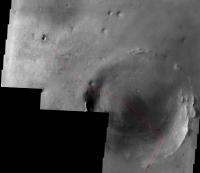
Just to put everthing in a wider context, I have assembled a false-color image made up of MOLA(red), THEMIS Day IR (green), and THEMIS Night IR (blue) images, grabbed as context images from the THEMIS site. The Red rectangle outlines a region which includes Victoria (the red cross) as well as everywhere else Oppy has been. The Big Crater is labeled.

|
This illustrates the variety of surface geology in the region. Clearly the Big Crater is the nearest target of any interest, with some unique properties which stand out nicely from the surrounding terrain. Far to the south are some more big craters and some large channel structures (remnant rivers?), but I'm afraid those will remain out of reach.
[edit] I notice that there is a distinct change in terrain about a third of the distance between Vicky and the near edge of Big Crater, which could by itself justify heading in that direction.
The THEMIS site is really quite nice.
Posted by: Astrophil Sep 23 2006, 07:55 PM
Lovely Cavafy poem. Let me throw in Tennyson's _Ulysses_ as well, seems quite apposite:
http://www.cs.rice.edu/~ssiyer/minstrels/poems/121.html
I cannot rest from travel: I will drink
Life to the lees: All times I have enjoy'd
Greatly, have suffer'd greatly, both with those
That loved me, and alone...
Posted by: algorimancer Sep 23 2006, 08:27 PM
I found an MOC image that goes right through the middle of Big Crater (BC):
http://www.msss.com/moc_gallery/e07_e12/images/E11/E1101328.html
Here's the hi-res version (not map projected). The north edge of the crater is a little above half-way down the image strip (wedge-shaped ridge, with point towards the left), the south edge is a crescent shaped ridge near the bottom of the image.
http://www.msss.com/moc_gallery/e07_e12/full_jpg_non_map/E11/E1101328.jpg
And finally, here's a labeled clip of that same image, clipped to exclude most of the region beyond BC.
|
|
There's some weird stuff going on in the southern portion of BC. The material is darker than elsewhere. What the heck are those black, channel-like features? I would guess shadows of ridges and fault lines, but I'd like to hear from someone with more geology experience than I have. Further to the south are hints of extensive layering. This place gets more interesting the more I look at it. We may just need to send MSL here if Oppy can't make it.
Posted by: Nix Sep 23 2006, 08:56 PM
Thanks for the search algorimancer..been wondering for more images of BC too but I've been to lazy and on the wait for other things to just happen
-the dark channel-like features are most probably basaltic-sand dunes.
Nico
Posted by: stevesliva Sep 23 2006, 09:05 PM
The Dune fan in me thinks they're sandworm tracks.
Posted by: Nix Sep 23 2006, 09:07 PM
Those would be mighty big sandworms
Nico
Posted by: algorimancer Sep 23 2006, 10:19 PM
Does anyone know what minerals are being highlighted in these THEMIS images?
|
|
I've looked all over the THEMIS site and am unable to find any mention of it.
Posted by: tim53 Sep 24 2006, 03:53 AM
http://www.msss.com/moc_gallery/e07_e12/images/E11/E1101328.html
Here's the hi-res version (not map projected). The north edge of the crater is a little above half-way down the image strip (wedge-shaped ridge, with point towards the left), the south edge is a crescent shaped ridge near the bottom of the image.
http://www.msss.com/moc_gallery/e07_e12/full_jpg_non_map/E11/E1101328.jpg
And finally, here's a labeled clip of that same image, clipped to exclude most of the region beyond BC.
|
|
There's some weird stuff going on in the southern portion of BC. The material is darker than elsewhere. What the heck are those black, channel-like features? I would guess shadows of ridges and fault lines, but I'd like to hear from someone with more geology experience than I have. Further to the south are hints of extensive layering. This place gets more interesting the more I look at it. We may just need to send MSL here if Oppy can't make it.
The portion that's darkest is on the slope of the "outcrop" where it drops off about 400 meters from the center of the crater to the south floor. THe dark features are dunes.
-Tim.
Posted by: SFJCody Sep 24 2006, 11:33 AM
I think the trickiest issue for the planners would be coming up with a driving strategy for the etched terrain that is suitably aggressive but can also avoid/correct for getting stuck in drifts.
It would take the rover 400 sols to cover 12km if it moves at an average speed of 30m per sol. Can this be done on the etched terrain? Maybe with a cycle of single sol 90m 'mostly blind' drives followed by two sols allocated to drift extraction (if needed).
Posted by: BrianL Sep 24 2006, 02:45 PM
This pales in comparison to the much bigger problem facing the members of this forum...
How do you tell when you've arrived at Big Crater so someone can win the inevitable arrival poll?
This issue alone could give the JPL planners second thoughts about attempting such folly.
Brian
Posted by: ustrax Sep 25 2006, 12:43 PM
-Tim.
Huumm...So what you are saying is that we now have two alternatives for Oppy...
Roving towards the Big Crater or be headed for the MSL landing site and cover it live for us folks back here on good old mother Earth?...
Posted by: marswiggle Sep 25 2006, 10:14 PM
On the excuse that the subtitle of this thread is 'premature speculation' I dare to present a premature routemap for the MER drivers. I went to the MOC gallery and found two narrow angle images adjacent to and east of S0500863, which cover the most part of the area between Victoria and the Big Crater (or Ithaca, as suggested):
http://www.msss.com/moc_gallery/e19_r02/images/E23/E2301344.html
http://www.msss.com/moc_gallery/e01_e06/images/E05/E0502642.html
To build this map I stitched the non-map-projected jpegs that are a bit 'flattened' but just therefore quite suitable for this purpose (though I had to hammer Victoria a bit flatter also). Below only the southern part shrunk to 60%, but it's still large (~1 Mb).
I think I found a relatively dune-free path for Oppy, so if she were driving say 200 m every other sol, she could reach 'Ithaca' around the Christmas 2007, after completing studies in Victoria next September.
|
Posted by: Bobby Sep 26 2006, 12:29 AM
Stay Tuned for upcoming event's.
Beacon 2 Poll for Big Crater
Details to come
Posted by: algorimancer Sep 26 2006, 12:47 PM
Just at the moment I'm a bit conflicted as to where to target in BC. Climbing to the top of one of the rim hills would yield one heck of a panorama, but considering how long it took Spirit to climb into the Columbia Hills, as well as the wear-and-tear (broken wheel) on the rover, it may be wisest to drive around the hills and target the (lake?) deposits at the southern portion of BC.
Posted by: Phil Stooke Sep 26 2006, 03:09 PM
marswiggle's mosaic is nice. I'd never looked out in that direction before but I was very interested to see a new type of terrain in the lower right corner. The surface is smooth and dark with numerous clearly defined (but very shallow) craters. The etched terrain had many vaguely circular markings, a lot of which were probably the scars of old eroded craters. But this new area looks different. So I think it would be worth looking at this area - about half way to the big crater - if such an extended mission were to be undertaken. (I'm not actually expecting anything after Victoria).
Phil
Posted by: algorimancer Sep 26 2006, 04:06 PM
In a broader sense, saving the hill climbing for late in the process to preserve rover health and maximize science opportunities, I would envision something like this:
|
This doesn't account for the dune orientation, which would undoubtedly lead to a lot of fine adjustments.
Posted by: climber Sep 26 2006, 04:18 PM
This doesn't account for the dune orientation, which would undoubtedly lead to a lot of fine adjustments.
It makes sense. Since the begining of Oppy's journey we're going down and down so, it'll be very important to explore features above what we've seen so far.
But, what I can't believe is that you've got project AFTER big crater. Good on you.
Posted by: algorimancer Sep 26 2006, 05:17 PM
There's some really cool stuff further south, including a couple of more BIG craters, and one or two old riverbeds. Sure it's not likely that we'll get that far, but who knows? Oppy may still be limping along 10 years from now. I think that after Victoria we could get to a point where we just trust the rover's navigation software to do what it's there for and just drive and cope with the terrain as needed - perhaps routine 100-300 meter drives every day or two.
Posted by: stevelu Sep 26 2006, 06:27 PM
That would be sweet, but I wonder if the large dark region in the center of the big crater is an Ultreya-like dune field that might be pretty much impassable to Oppy. Hard to tell at the resolution of that part of the image.
We should be so lucky that the terrain inside the big crater becomes a problem!
Posted by: djellison Sep 26 2006, 06:33 PM
The absolute record, with perfect terrain and a 100% healthy vehicle is 220.
With half the power, one broken steering actuator.... I would aruge that the very most we could dream of is 150m in any one sol.
Doug
Posted by: JRehling Sep 26 2006, 06:45 PM
Phil
If there's no route into Victoria, it would shorten the stay there and boost the chances of something beyond there -- for good or for bad.
Posted by: antoniseb Sep 26 2006, 06:54 PM
Perhaps future rovers should be equiped with anchors, cables, and winches.
Posted by: odave Sep 26 2006, 07:00 PM
...or piggyback a couple of http://www.space.com/businesstechnology/technology/spider_bot_030129.html
Posted by: imipak Sep 26 2006, 07:11 PM
I've been biting my lip on this subject as I half-remember seeing a more appropriate forum or topic somewhere else, but as you've brought it up...
A few small (intuitively) simple devices could greatly multiply the abilities of a future rover. In particular, a way to perform in situ sampling/observations on inaccessible slopes. From a geological perspective, the most places with the densest concentration of interesting features are by definition inaccessible to a wheel rover (cliffs in particular.) I'm thinking in particular of that happy day when my great-grandchildren are watching (live, 3D, full-spectrum imagery beamed straight to the visual centres of their brains, no doubt) of the first explorations of Valles Marineris, but there are plenty of less dramatic locations. I've seen variations on the "fly slowly by the cliff-face" idea - tethered balloons and such like - but what we really need is a mechanism to winch the IDD (and a pancam) over and down cliff and outcrop sites, and then reel it back in without it getting snagged and dragging the rover over the edge or getting damaged banging into rocks.
Back to ^r-land
Posted by: climber Sep 26 2006, 07:25 PM
MSL will have a laser to blow rocks and do simple analysis from a distance up to 9 m. This can solve the issue when you're looking up i.e. when you're at the foot of a cliff. When you're looking down, may be a "crane" could be considered to lower down instruments and it could also be used the other way around to anchor a rover descending a slope like the ones we can see here, at Victoria
Posted by: Bart Sep 26 2006, 09:40 PM
Actually JPL is already working on this. I attended a lecture up there a couple of months back that demonstrated such capabilities. The presenter was a guy I went to grad school with.
Here's a link: http://www.jpl.nasa.gov/events/lectures/may06.cfm
Posted by: ilbasso Sep 26 2006, 09:56 PM
Maybe we'll learn that the rovers have little rockets, like we learned about R2D2 in movies subsequent to Star Wars Episode IV. What's the special effects budget for these guys?
Posted by: jamescanvin Sep 26 2006, 10:41 PM
Notice in todays http://marsrovers.jpl.nasa.gov/gallery/press/opportunity/20060926a.html they agree that the main peak is on the far (SE) rim of the big crater (35km away)
Also note that some smaller features can be seen in todays pancams.
http://qt.exploratorium.edu/mars/opportunity/pancam/2006-09-26/1P212524999EFF76CNP2386R1M1.JPG
I haven't looked at the angles but I would bet that those are the hills on the west side of the crater that SFJCody plotted the route too in the first post of this thread.
James
Posted by: algorimancer Sep 26 2006, 11:36 PM
Nico
Any chance you could link a pic of a terrestrial equivalent? While I don't doubt that they are basalt, I've looked around for dunes similar to these, without any luck.

|
The only terrestrial feature that I've found (so far) that resembles these features is eskers or collapsed lava tubes. Any chance they could be eskers? They don't look much like collapsed lava tubes.
I found a LPSC2006 reference to eskers on Mars - apparently they're not unknown:
http://www.lpi.usra.edu/meetings/lpsc2006/pdf/2035.pdf
Another reference I stumbled upon while googling "sinuous ridge" was to trapdoor faulting in a volcanic caldera. This seems also not out of the question as an explanation. Could really use some more hires pics.
Posted by: MaxSt Sep 27 2006, 06:08 AM
I don't get it... On which rim of Big Crater are New Twin Peaks exactly? How far are they?
Posted by: jamescanvin Sep 27 2006, 06:23 AM
The twin peaks are on the north rim of the big crater, roughly 18 to 20km away I would say.
James
Posted by: MahFL Sep 27 2006, 10:43 AM
James
JPL says they are 19 km away, so James is correct.
Posted by: RNeuhaus Sep 27 2006, 03:05 PM
You can check it by visiting the JPL http://marsrovers.jpl.nasa.gov/gallery/press/opportunity/20060926a/Opp_Vic_Approach_Ncam_labels-B951R1_br2.jpg
Rodolfo
Posted by: MaxSt Sep 27 2006, 07:50 PM
Thanks! We can even see SE rim at 35 km distance, amazing.
Posted by: ustrax Sep 29 2006, 02:09 PM
And the details are starting to show up...http://i16.photobucket.com/albums/b14/ustrax3/ithaca2.jpg...
:
Posted by: climber Sep 29 2006, 03:41 PM
:<Clink> <Clink> <Clink> <Clink> <Clink> <Clink> <Clink> <Clink> <Clink> <Clink> <Clink> <Clink>
We need to open another box!
I'm sure we can deduce height and size from that.
Ustrax, one again, you've picked up something important, and you're very good to match features (except the Beacon
)Thanks
Posted by: Castor Sep 29 2006, 03:57 PM
I don't know if anyone else has already spotted this, but I think we can also see the west rim of Big Crater directly beyond Cabo Frio about 15 km away, although it's very subtle. I've labelled the north, south-east and west rim peaks as A, B and C in this montage:
|
Thanks to DEChengst for the pancam mosaic.
Castor
Posted by: ustrax Sep 29 2006, 04:30 PM
Yes, I've seen it Castor.
I did the same as before with the ones you made reference to.
It is just an attempt, don't know if it is correct (au contraire of what climber says I'm not good at matching features...just ask pando or james...)...But, by now, we got all the time in the world for divinatory arts...
:http://i16.photobucket.com/albums/b14/ustrax3/ithaca3.jpg
Posted by: tim53 Sep 29 2006, 04:35 PM
Also note that some smaller features can be seen in todays pancams.
http://qt.exploratorium.edu/mars/opportunity/pancam/2006-09-26/1P212524999EFF76CNP2386R1M1.JPG
I haven't looked at the angles but I would bet that those are the hills on the west side of the crater that SFJCody plotted the route too in the first post of this thread.
James
I didn't plot the latter peaks in the update because I'm still not sure which they are. The are in line with the southwest rim of the 22km crater, but the height of the rim there doesn't seem sufficient for them to be visible from Victoria. The topography map I'm using was generated from the 128ppd gridded data, however, so it is possible that the pixel over that part of the rim is averaged with the surrounding elevations, and reduced accordingly. I did check the individual ground tracks, and there isn't a gap in the coverage there, so the peak's elevation should have been sampled. I didn't check the individual profiles to see if the values differ from the gridded data there, though.
Those peaks "appear" farther than the southeast rim peak, which is 35 kilometers away. The southwest rim peak, tangent to the line of sight from Duck Bay, is between 18 and 26km away. There are two other large crraters past the 22km crater in this direction that *might* have peaks on them tall enough to be seen from Victoria. The first one is 41km (near rim) to 48km (far rim) from Duck Bay, with rim peaks over 120m tall. The second one is 56km - 68km away, and has rim peaks that are higher, but my topomap doesn't cover its southeast rim, so I don't know what the height is.
Based on the Pathfinder experience, where we had a 450m tall streamlined island that was over 30km away and easily visible, and based on the fact that the topography slopes down away from Victoria to the 80m+ lower plains that these craters are on, I think it's possible to see this far even with Mars' curvature. But I think we will just have to wait and see if one of the higher promontories around Victoria will give us a better view of the horizon.
-Tim.
Posted by: centsworth_II Sep 29 2006, 05:55 PM
Is this an arrival sol poll thread? My pick is sol 2560.
Posted by: karl Sep 29 2006, 06:30 PM
With half the power, one broken steering actuator.... I would aruge that the very most we could dream of is 150m in any one sol.
Doug
And with a very long extended mission, I would think that a dropoff in the ability of the battery to fully recharge would kick in, further reducing the power available for drives and science activities. I don't know off the top of my head the what the battery capabilities and projected lifetime are.
Posted by: lyford Sep 29 2006, 07:34 PM
Well, http://www.unmannedspaceflight.com/index.php?s=&showtopic=1708&view=findpost&p=37513, we have about 10,000 recharge cycles to play with before we need to worry...
Posted by: Arkarch Sep 29 2006, 08:24 PM
Echoing some of the other discussion - I think we'll be looking around the rim quite awhile before we go in - and I dont think they'll send Oppy down unless they have a good probability of getting out. So they'll find best paths and best targets to get the science they need.
Beyond that.... whew... reach "Big Crater" on day 2500+ I would suspect they will need several intermediate goals to justify funding another 1000-1200 days. But beyond the science, keeping Oppy and Spirit around allows JPL/NASA to train new operators and try out new software for the benefit of future rover missions.
- . -
This mission is starting to take on "Voyager" - like timelines. 2 1/2 years to reach Victoria, a year in Victoria, another 3 years to "Big Crater" Sooner or later Oppy will encounter alien intelligence, gain self-awareness, and come back to haunt mankind like some sorta Star Trek movie plotline
- . -
Posted by: nprev Sep 29 2006, 08:29 PM
<clink><clink><clink>...oops. Does the swear jar accept plastic? I have a debt to pay...
Fantastic work, ustrax....talk about a tantalizing long-term goal on the horizon...
Posted by: climber Sep 29 2006, 08:29 PM
If they attempt to get to Ithaca, can you imagine they could send a command once a week for the rest of the week and get results by the week-end? Can you imagine that ???
Posted by: fredk Sep 29 2006, 09:29 PM
I've been wondering about that myself, Climber. How much independence could we program into these babies? Is it conceivable to imagine a very long-term mission with a much lower funding level, with Oppy rolling along as best it can on its own towards the "big crater" or wherever, with only occasional input from earth? Some weeks she might make great progress, while others she may wait for days for help from home.
I'm sure the answer depends greatly on the terrain. I couldn't imagine software that could get you safely and reasonably quickly through the worst ripples of the etched terrain. But then I don't do image processing.
Also, perhaps with higher resolution orbital MRO imagery a safe path could be laid out and Oppy simply programmed to follow it, with occasional position checks from Earth to correct for cumulative errors.
Posted by: ustrax Sep 29 2006, 09:32 PM
- . -
5 1/2 years?!?...I'm counting with it for MSL arrival as the limit...
When I'm being optimistic I see it in June, 2008...
Are we following an escargot or Oppy?, the self sustainable rover?!...
nprev...Let's wait for the pros to say something...
climber...That made me laugh out loud on this cyber and people here aren't aware of the "miracle" we're witnessing, neither will they if we arrive to Ithaca...So, let's keep it simple...BY what I've been aware of extended mission funding is coming...
EDITED: Great approach fredk!!!
That's the Spirit leading Opportunity towards Ithaca...
After Troy Ulysses made it on it's own back home...
This is a great Tomorrow's topic! The kind we'll be back in some years from now...
Posted by: nprev Sep 29 2006, 10:49 PM
Oh, of course...that was merely unbridled wishful thinking. If Oppy made another 35 km, Lockmart should come back to the government at that point and demand royalties!
Still...it sure would be nice if, on that sad future day when this unbelievable mission ends, those hills at least fill the horizon of the last panorama, showing tantalizing new features while the surrounding landscape gradually transitions into a new geological province...
Posted by: Sunspot Sep 29 2006, 10:54 PM
This thread is more active than the Victoria Crater one. Are people bored with Victoria Crater already?
Posted by: Pando Sep 29 2006, 11:24 PM
The grass is always greener on the other side of the fence...
Posted by: jamescanvin Sep 29 2006, 11:28 PM
:I haven't got time to do the maths but from previous work I would bet that your match is wrong. I think we're looking at a much smaller part of the rim. I would guess that the whole feature is between your rightmost two circles.
Tim, thanks for the reply. Now you mention it those do 'look' further. Is there any way of estimating the distance based on how 'hazy' the hills look and the atmospheric Tau?
James
Posted by: Nix Sep 29 2006, 11:35 PM
Bored yes, you'd think so wouldn't you? Here's one heck of a crater right in front of us but we just have to reach beyond, already..
I admit I'm fascinated by that big crater too though -it's always a thrill spotting horizon features and having data from orbit to compare..I remember spending a lot of time doing that in Pathfinder days
Nico
Posted by: djellison Sep 29 2006, 11:40 PM
It's much like the Gusev Crater Wall imaging from back in the Bonneville->Cahokia days
Doug
Posted by: Nix Sep 29 2006, 11:46 PM
Exactly, ahh those were the sols.. This robotic adventure keeps rocking, better than ever I'd say, but I remember well those first months, the excitement, the dreams -that became
Nico
Posted by: RNeuhaus Sep 29 2006, 11:55 PM
Before deciding to go to Ithaca, I seem that there will be a question:
For the distance of 20 km
- Drive as fast as possible: average of 50 m/sol, 400 soles
- Stop as many time as desired for any science activities: average of 20 m/sol, 1,000 soles.
The suggestion of Fredk is very good, Try to get the support from MRO team to take a high resolution image on Big Craters zone in order to select the best route in order to maximize the automated navigation.
Now it is still another big dream!!!
Rodolfo
Posted by: Sunspot Sep 30 2006, 12:19 PM
Where will Opportunity go next?
If the rover survives this adventure, another one is around the corner. "There's an even bigger crater to the south, 7 kilometres away," Banerdt says.
http://www.nature.com/news/2006/060925/full/060925-16.html
Posted by: Nirgal Sep 30 2006, 01:16 PM
For the distance of 20 km
- Drive as fast as possible: average of 50 m/sol, 400 soles
- Stop as many time as desired for any science activities: average of 20 m/sol, 1,000 soles.
<wild-speculation-mode on>
The problem with this mixed strategy (drives and science-stops) is the very fact that the remaining
rover life span is limited ... therefore, in order to reach the really big goals we must set very hard priorities: A "big crater" or B "science-stops". While it's even unlikely to get A it's simply impossible to get both.
So if we want to have a chance to reach such a goal at all, the strategy must be
different from the conventional drive-and-stop policy used so far.
The new strategy would be:
1. use every possible drive sol to drive the maximum possible distance.
2. no science stops, not even then if (moderately) new things are encountered on the way
3. only exceptions:
- regular brief stops, say every 20 drive sols or so in order to track and document geological changes along the way
- a very new discovery pops up along the way whose "scientific newness" is so exceptional that the expected scientific value of it's investigation outweighs the *total* expected scientific value of the original
goal
Of course this means deliberately taking the risk to loose a couple of hundred drive-only sols
(that had otherwise been used for routine science stops) in case of a premature failure before reaching
the final goal. But this risk is just the price to be paid for the chance to reach the "big goal".
Actually we had already seen a bit of this chance in drive policies for the part where Oppy crossed the
plaines between Erebus and the Victria Apron.
Who knows if we had ever reached Victoria, had Oppy spent many dozens of Sols of additional
intermedient science stops during that time.
</wild-speculation-mode off>
Rodolfo
Yes, in the end it's our dreams and imagination that fuel and drive any exploration and science ...
Posted by: ustrax Sep 30 2006, 02:31 PM
I'll only be satisfied when Oppy reaches the antipodes of her landing site...
Posted by: Floyd Sep 30 2006, 03:23 PM
The overriding goal of the mission is science return. The goal for any future block of time is to maximize science return during that block of time. A consideration in committing to a long time block is the probability of the rover being alive at the end of the time block.
In equation form:
Science Return = Potential Science Return/Time taken x Probability of being alive
Probability of being alive is probably proportional to e^-t/k where k is the expected half life of the rover. I think that the two wheel failures and the IDD motor problem indicate k is less than 1000 days. Id pick k = 500 days.
I think Opportunity will probably spend the current mission extension exploring Victoria because great science is right at hand.
Posted by: centsworth_II Sep 30 2006, 03:38 PM
I don't think anyone here expects or wishes for less than a year of exploration at Victoria. Still, it is fun to make plans for a rover still going two years from now.
Posted by: SFJCody Sep 30 2006, 04:47 PM
Maybe more...
http://homepage.ntlworld.com/sfjcody2/crater.jpg
Posted by: fredk Sep 30 2006, 05:03 PM
There's nothing even close to VC size 7 km southish from VC on the Themis composite. Just an Endurance-class guy to the southeast. Probably a typo.
Posted by: SFJCody Sep 30 2006, 05:29 PM
There is a crater about that distance away to the west. I hope they choose 'Big Crater' instead though.
http://www.msss.com/mars_images/moc/2004/01/24/
Posted by: ustrax Sep 30 2006, 07:19 PM
http://www.msss.com/mars_images/moc/2004/01/24/
Hey! That looks very good as a mid-term goal towards Ithaca!
Very very nice!!!
Hey floyd..."probably proportional to e^-t/k"...?! ?! ?!
We're dealing with the improbable here...And the improbable can't be measured...Just executed...
Posted by: SFJCody Sep 30 2006, 08:12 PM
I don't think so... it's in almost the opposite direction!
Posted by: ustrax Sep 30 2006, 09:16 PM
Bah!...There you go...
A good direction is like Xmas...Is
where a man wants it to be...
Posted by: algorimancer Sep 30 2006, 09:39 PM
On the contrary, I'd prefer to spend no more than 3 months at Victoria, then head east for Big Crater (BC) with minimal stops along the way. If I were driving I would immediately drive down Duck Bay, stopping every few meters for instrumental measurements of the geological section, then skirt the dune field while on a slope which maximizes the sunlight on the solar arrays, taking lot's of color panoramas as we go, then drive up some bay on the opposite side (with perhaps a few more geo stops going up the vertical section), then spend the summer going all-out towards southern BC, and spend next winter on the sun-facing slope of BC's south-rim hills (or at least on the west-rim hills).
Posted by: ToSeek Oct 1 2006, 01:37 AM
Why? The rovers were built in-house at JPL. Lockheed Martin was only responsible for the aeroshell. Even if they were the prime contractor, I'd say LM can get royalties as soon as they reimburse NASA for the Mars Climate Orbiter, Genesis, and HESSI.
Posted by: sranderson Oct 1 2006, 05:16 AM
Ball Aerospace built the pancam mast, the high gain antenna and gimbal, the power distribution and control modules, the pyro firing circuit modules, and the REU avionics boards (telem for cruise and lander).
Posted by: Bill Harris Oct 1 2006, 06:21 AM
BC ought to be a goal since that is the way our primate psyches are wired. But the purpose of the journey has to be science stops along the way since Down Section is the actual Prime Directive.
--Bill
Posted by: edstrick Oct 1 2006, 09:10 AM
If they ever decide to make a dash for the big crater, it will be with ***FAR*** better routemaps than they have now... with highest possible resolution data from HiRISE and probably 3-D high resolution topography as well.. and CRISM spectrometry of the route, they could plot a route that can likely be navigated much better than the route to Victoria, and pick "5 day" science stops every 2 weeks or some such with more assurance they'll hit the important en-route variations.
Posted by: djellison Oct 1 2006, 11:15 AM
You want to spend less than half the time they spent at Endurance, to explore twice, three, four time the exposure of outcrop?? That woudl be selling the place short wouldn't it?
Seriously guys - 'Big Crater' may be a nice pipe dream, and it may be somewhere worth aiming for if we were totally and utterly finished with Victoria....but to cut short investigation of the most extensive and amazing opportunity yet for a goal which realistically we can not expect to reach would be silly imho.
Doug
Posted by: ngunn Oct 1 2006, 12:17 PM
--Bill
Maybe I'm not primate?
 Having spent years crossing an interesting-because-unearthly but nevertheless monotonous plain to get to this wonderful place I have absolutely no desire to set out on another long trek. Let's just stay and get to know Victoria really well. Not just the solid geology but every aspect of the local environment - dawns and sunsets, microclimate and crater wind patterns, dust transport processes, seasonal changes.
Posted by: Bill Harris Oct 1 2006, 12:50 PM
Oh, I agree. If the old girl is still able to rove and seems healthy after a thorough Victoria investigation, we might consider extending the traverse. But OTOH, setting Oppy in good locations to watch erosional-depositional processes as a semi-sessile base station would work as well, or better.
As a geologist-primate, my ancestral urge is down-section.
--Bill
Posted by: nprev Oct 1 2006, 01:02 PM
I stand corrected, sranderson & ToSeek; was just trying to make a (pretty lousy, really) joke...
And actually, I'm coming around to the idea of staying at Vicky for quite awhile. It looks like there's a lot of stuff to do here, and risking Oppy on a mad dash to a distant goal at her advanced age seems unwise unless and until VC is first thoroughly explored.
Posted by: Sunspot Oct 1 2006, 01:17 PM
On the right tip of the landing ellipse, just outside of it, there are two eroded craters. They both have white features in the middle. Are those dunes or large mounds of eroding outcrop? There was also one North of Endurance Crater, about the same distance north as Victoria is south.
http://www.msss.com/mars_images/moc/2004/01/24/
Posted by: Oren Iishi Oct 1 2006, 01:32 PM
And actually, I'm coming around to the idea of staying at Vicky for quite awhile. It looks like there's a lot of stuff to do here, and risking Oppy on a mad dash to a distant goal at her advanced age seems unwise unless and until VC is first thoroughly explored.
I have an idea. Why doesn't NASA use the spare rover at the JPL lab and send it as close to BC as possible. Obviously, it's a proven design and probably could be done very inexpensively. Plus, this should fill the gap nicely until the Mars Lab Rover gets to the planet. MRL shouldn't go to BC, it should go to region on Mars that gets very little sunlight since the RTGs will supply the power and not solar cells.
Posted by: algorimancer Oct 2 2006, 01:24 PM
My recollection (and I'm sure someone will correct me if I'm wrong) is that the rover at the JPL lab is more a prototype than a spare, and not really "complete" in the sense that it could be dropped on Mars and function. On the other hand, at this point it would likely be relatively inexpensive to assemble a genuine duplicate rover, as the design work has already been done. I have had a recurring fantasy of setting-up a little assembly line to mass produce these things and drop them all over Mars. Still, building the rover is only a small part of the cost; it remains terribly expensive to actually deliver it to Mars.
I agree that MRL shouldn't go to BC, there are plenty of unexplored regions with interesting geology.
Posted by: ToSeek Oct 2 2006, 03:11 PM
I realize you weren't particularly serious, but I still didn't want LM to get credit where credit wasn't due, particularly since they have a long history of million-dollar screwups.
Posted by: algorimancer Oct 2 2006, 05:43 PM
Seriously guys - 'Big Crater' may be a nice pipe dream, and it may be somewhere worth aiming for if we were totally and utterly finished with Victoria....but to cut short investigation of the most extensive and amazing opportunity yet for a goal which realistically we can not expect to reach would be silly imho.
Doug
Why less than half the time? To begin with, this is all fantasy, the JPL folks aren't gonna do what I recommend, and I know it. At the same time, let's place the exploration of Endurance and Victoria into context. Endurance was the first major exploration target of the mission, so a lot of caution was appropriate. We were still learning about managing rover operations, and didn't know much yet about how the rover would interact with the new environment - slopes and different materials and so on. A lot of learning needed to take place. Subsequently the rover ops have become pretty routine, we have a pretty good idea of how the rover will handle the different terrains and slopes associated with Victoria, and today's navigation software is a lot more robust. In principal, we can do a lot more science in a lot less time (barring Mossbauer (integration, assuming that's the instrument with the decaying radioactive source). The main thing of interest in Victoria is the vertical geological section, which can be surveyed neatly during crater ingress and egress, horizontal exploration won't add much to that. So, we make an initial pass through the geology on ingress, identify portions worth additional exploration, and hit those in depth upon egress. We take lot's of pretty pictures along the way, along with mini-TES. The main limiting factor that I see is how densely to sample the surface during ingress/egress, and considering the depth of the crater I may be underestimating this. In summary, I'm not suggesting that we cut-short the investigation of Victoria, merely that we be expeditious about it, and move on once we've reached a point of diminishing returns. Yes, 3 months is probably ridiculuously optimistic, but I think that 1 year is excessively pessimistic. Perhaps 6-9 months would be about right. What I'd like to avoid is getting into the mind-frame that Victoria is where Opportunity goes to die.
Posted by: BrianL Oct 2 2006, 08:31 PM
Spirit has demonstrated, albeit out of necessity, that you can spend many, many months in one location gathering information. There is easily enough science work at VC to use up its year of funding commitment.
Should that funding be extended yet again? Is the science to be gained on a post-VC trek worth allocating money that might be better spent on another mission?
Everything I've had access to painted VC as an ultimate goal. Probably an impossible one, but one to consider if it lasted long enough. If there are other targets beyond VC that JPL wanted to get to, let me know. As it stands, I think the best course is to let Opportunity finish up its roving science at VC, then largely pull the plug next autumn. Put Opportunity up high on the rim of Victoria Crater to finish her days making long term observations and measurements. Let the MER team walk away by choice, heads held high that not one goal... no matter how pie in the sky it seemed initially... was left unfulfilled.
Maybe there are better spots from a scientific standpoint, but from a purely emotional perspective, I know where I want Opportunity to come to rest. We saw it from afar, even if we couldn't agree where it was for the longest time, and the romantic in me can see it as Mars' way of saying, "I know it's tough, but keep going little rover, you're almost home".
Let Opportunity find a home at the Beacon... call it Opportunity Point as a fitting tribute to the team of people that gave us this wonderful adventure. Do you really want to wake to the news that motor failure has left the rover stuck in some anonymous ripple out on the plains, half way to nowhere?
Brian
Posted by: sranderson Oct 2 2006, 09:02 PM
Hmm.... give us some free comm time, a little training, and I bet a group of the folks here would volunteer to keep Oppy going for several years.
If you stay in one spot you are almost sure to find nothing new, but you never know what you might find if you keep roving.
Yes, I would rather see Oppy die in the middle of nowhere while trying to do something, than retire in place, running down to nothing for no purpose.
"Rove until Death!"
Posted by: dvandorn Oct 3 2006, 04:48 AM
I cannot conceive of them cutting off funding on either rover if they're still working and in reasonably good health.
The instruments are *already* on Mars, and have worked extraordinarily well. Just the Pancam images, with all their filters, are highly valuable, even if the mini-TES and the IDD sensors break.
Does it make sense to spend the money on platforms that are already performing on Mars, or on platforms that we hope will successfully land there someday? (Yes, we ought to do both -- but I can't see foresaking working explorers to put the money into another program that might possibly end up elsewhere from where they're targeted, like the bottom of the Atlantic...)
-the other Doug
Posted by: ustrax Oct 3 2006, 09:18 AM
Couldn't agree more.
This babies are of a...roving kind, I'd rather see them proudly getting silence while on duty.
Sending us a last image as a farewell from somewhere ahead, beyond Victoria.
Opportunity (and Spirit...) are the perfect ambassadors of human nature, by saying that our adventure on Mars won't stop where predicted but when the last breath is taken.
Posted by: mchan Oct 4 2006, 07:46 AM
Likewise, I like to imagine Opportinunity on her final trek across the great desert beyond, going until she can't go any further...
Posted by: edstrick Oct 4 2006, 11:23 AM
....sort of like the cartoon of an alien, crawling across desert sands, away from ?his? crashed flying saucer, and saying: "Ammonia! Ammonia!"
Posted by: NoVi Oct 7 2006, 06:06 AM
Pity that Big Crater fell just out of the scope of yesterday's MRO imaging.
Posted by: djellison Oct 7 2006, 06:47 AM
LOL - 'just' - you'd need another two HiRISE images to get across to it.
Doug
Posted by: CosmicRocker Oct 7 2006, 08:33 AM
LOL?
Posted by: djellison Oct 7 2006, 07:31 PM
Laugh Out Loud
Posted by: CosmicRocker Oct 8 2006, 05:40 AM
Sorry, Doug. I should have explained it better. I know what LOL means, I just didn't get the joke. NNTR.
Posted by: djellison Oct 8 2006, 06:01 AM
I was laughing at the thought that 'Big Crater' was just outside that HiRISE image...which it isn't. You would need another two swathes widths to get there.
Doug
Posted by: NoVi Oct 8 2006, 09:37 AM
Oops,
The orientation of the .._1780 image was upside down compared to images I normally see of Victoria/ Big Crater
Which brings me back to my orginal question:
is there some time line/ planning what parts of Mars are being imaged by MRO? Or is it for outsiders purely coincidental what images become available?
Posted by: RNeuhaus Oct 9 2006, 12:30 AM
As far as I know, MRO will take pictures landing sites for Phoenix as the highest priority since the spring in the northern hemisphere is approaching soon and that seasson will be a problem with the increase of dust density in the atmosphere. Later, the other priorities is around the Chasmas as the one of the favorites MSL landing sities.
Rodolfo
Posted by: nprev Oct 9 2006, 12:47 AM
Preachin' to the choir, here...I used to do avionics maintenance on C-5s & C-141s. Whenever a malfunction would abruptly disappear for no apparent reason, we'd call it a "Lockheed fix"...
Posted by: mcaplinger Oct 9 2006, 02:04 AM
What did they have to do with HESSI? (which was nearly trashed by an inhouse test accident at JPL.)
Posted by: Stephen Oct 9 2006, 02:12 AM
You mean http://www.daviddarling.info/images/ammonia_cartoon.jpg?
======
Stephen
Posted by: edstrick Oct 9 2006, 08:28 AM
Almost certainly the same one... though my memory is sort of the mirror image.. crawling off to the right...but that memory is many many years old.
Grin!
Posted by: AndyG Oct 9 2006, 11:02 AM
======
Stephen
EXCELLENT! I knew the drawing from the description - it was in a compilation of classic New Yorker cartoons that accompanied me through my childhood - but I hadn't seen it for about thirty years. Until Today.
Marvellous, and many thanks Stephen,
Andy
Posted by: lyford Oct 9 2006, 03:02 PM
I bow to your mad google skills - I gave up after a few minutes of false hits.
I saw this cartoon as a kid IIRC in the TimeLife book series on Life I think...
Posted by: ToSeek Oct 9 2006, 05:14 PM
Oops, wrong accident! I was thinking of the http://www.spaceref.com/news/viewsr.html?pid=10299, where the satellite fell over, causing millions in damage, because LM personnel did not follow proper procedures.
Posted by: Myran Oct 10 2006, 02:00 PM
I tend to agree with edstrick that the image might have been flipped. Then again, the signature are not so I guess tere been two versions of it by the same cartoonist. (And I go smack myself with a brick so I stay on topic from now on)
Posted by: imipak Oct 11 2006, 02:51 PM
Heh, Auntie Beeb had me going for a moment there...
I can't see that Oppy would be sent off on a probably fruitless quest for Ithaca/BC, as the value of a motionless rover with broken wheels but working cameras would surely be considerably higher perched on the rim (or inside) VC than stranded out on the plains somewhere between VC and BC. The variable relief would be likely to lead to more useful data on seasonal changes in wind, tau, dust accumulation/removal and so on. Oppy at VC would still be able to do 'fairly remote' sensing of conditions on the plains, but would also have a feature within which to look for microclimates or other localised phenomena.
Posted by: MarkL Oct 11 2006, 04:27 PM
And since Victoria seems to be eroding, Opportunity can witness the process in action from a high promontory, while watching the seasons pass for several years. I'll bet a couple of chunks will calve off the walls at some point over the next few years. Would certainly be more interesting than watching sand blow across a featureless, flat plain.
Posted by: ustrax Oct 11 2006, 04:46 PM
 The nature of Opportunity is to rove, http://www.unmannedspaceflight.com/index.php?s=&showtopic=3215&view=findpost&p=69087.
Posted by: imipak Oct 11 2006, 06:41 PM
The nature of Opportunity is to rove, http://www.unmannedspaceflight.com/index.php?s=&showtopic=3215&view=findpost&p=69087. Does a Mars Exploration Rover have the Ustrax nature?
Posted by: RNeuhaus Oct 12 2006, 02:02 PM
MER was born luckly with wheels so she is very lucky to be able to rover to the end toward the Ithaca crossing any permissible road.
Rodolfo
Posted by: ustrax Oct 12 2006, 03:46 PM
On the day you say yourself "Enough!" , you are already dead.
You shall always endure, you shall always go onward, you shall always walk.
Don't stop on the way, do not withdraw, don't leave the way.
That one that does not advance, stays behind
Saint Augustine
(Translated by me, can someone please find a correct english version?...)
Posted by: ustrax Oct 30 2006, 01:57 PM
Wouldn't it be great to multiply Victoria's "WOWs" 20 times?
We would need a XXL swear box...
http://i16.photobucket.com/albums/b14/ustrax3/ithaca_vic_comp.jpg
Posted by: Edward Schmitz Oct 30 2006, 09:13 PM
The realy interesting thing about big crater, to me, is that it appears to predate the evaporite layers that opportunity has been investigating. The sediments seem to drap over the crater and the original rim is poking through in some spots. If we could investigate those peaks, we might see unaltered rock that pre-date the evaporite layers.
That would be exciting...
ed
Posted by: Stephen Oct 31 2006, 12:49 AM
Of course, nobody will know what interesting things are over there unless and until Opportunity actually goes.
======
Stephen
Powered by Invision Power Board (http://www.invisionboard.com)
© Invision Power Services (http://www.invisionpower.com)