Journey to Mt Sharp - Part 3: Cooperstown to Kimberley - Waypoint 3, Sol 453 [Nov14,'13] to 595 [Apr9,'14] |

  |
Journey to Mt Sharp - Part 3: Cooperstown to Kimberley - Waypoint 3, Sol 453 [Nov14,'13] to 595 [Apr9,'14] |
 Mar 10 2014, 01:46 PM Mar 10 2014, 01:46 PM
Post
#706
|
|
|
Solar System Cartographer  Group: Members Posts: 10151 Joined: 5-April 05 From: Canada Member No.: 227 |
Yes, hidden behind the bright outcrop just below the dark dunes.
Phil -------------------- ... because the Solar System ain't gonna map itself.
Also to be found posting similar content on https://mastodon.social/@PhilStooke Maps for download (free PD: https://upload.wikimedia.org/wikipedia/comm...Cartography.pdf NOTE: everything created by me which I post on UMSF is considered to be in the public domain (NOT CC, public domain) |
 |
 
|
|
Mar 10 2014, 01:57 PM
Post
#707
|
||
|
Solar System Cartographer Group: Members Posts: 10151 Joined: 5-April 05 From: Canada Member No.: 227 |
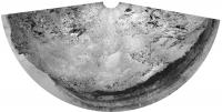
Here's a quick circular view of our sol 565 location, looking out over the route to Kimberley.
Phil
-------------------- ... because the Solar System ain't gonna map itself.
Also to be found posting similar content on https://mastodon.social/@PhilStooke Maps for download (free PD: https://upload.wikimedia.org/wikipedia/comm...Cartography.pdf NOTE: everything created by me which I post on UMSF is considered to be in the public domain (NOT CC, public domain) |
|
|
|
|
|
|
Mar 10 2014, 07:46 PM
Post
#708
|
|
 Senior Member Group: Members Posts: 1619 Joined: 12-February 06 From: Bergerac - FR Member No.: 678 |
Sol 565 Navcam panoramic. I was waiting for one frame to be complete
Yes, I'm working exclusively with the left camera ^^
-------------------- |
|
|
|
|
Mar 10 2014, 11:04 PM
Post
#709
|
|
|
Solar System Cartographer Group: Members Posts: 10151 Joined: 5-April 05 From: Canada Member No.: 227 |
Looks like a short drive towards that dark rock - either for in situ work on the rock, or just for wheel imaging before the next drive.
Phil http://www.midnightplanets.com/web/MSL/ima...HAZ00302M_.html -------------------- ... because the Solar System ain't gonna map itself.
Also to be found posting similar content on https://mastodon.social/@PhilStooke Maps for download (free PD: https://upload.wikimedia.org/wikipedia/comm...Cartography.pdf NOTE: everything created by me which I post on UMSF is considered to be in the public domain (NOT CC, public domain) |
|
|
|
|
Mar 11 2014, 10:12 AM
Post
#710
|
|
 Member Group: Members Posts: 809 Joined: 3-June 04 From: Brittany, France Member No.: 79 |
Panorama taken on sol 565 with MastCam34mm:
 And a version in false colors and contrast stretched, to emphasize color differences between rocks:  I think we can see some part of the striated unit on this panorama. On the left part of the panorama, there are three linear horizontal outcrops. The third one (the farthest) may correspond to the striated unit: if one compares with this map of Phil, this is the striated unit at the center of the map. -------------------- |
|
|
|
|
Mar 11 2014, 05:51 PM
Post
#711
|
|
|
Senior Member Group: Moderator Posts: 4279 Joined: 19-April 05 From: .br at .es Member No.: 253 |
QUOTE (mcaplinger @ Mar 11 2014, 06:24 PM)  This discussion should probably be moved over to the images and cameras subforum. Moved to the MSL Images & Cameras, technical discussions of images and cameras thread, starting here. |
|
|
|
|
Mar 12 2014, 09:13 AM
Post
#712
|
|
 Senior Member Group: Members Posts: 2428 Joined: 30-January 13 From: Penang, Malaysia. Member No.: 6853 |
Update On Curiosity From USGS Scientist Ken Herkenhoff: LINK to Ken's full report
QUOTE ...Unfortunately, the Mars Reconnaissance Orbiter (MRO) suffered an anomaly Sunday that interrupted the relay of data from MSL to Earth. Therefore, the drive planned for Sol 567 was cancelled and targeted ChemCam and Mastcam observations of nearby rocks were planned instead. MSL data are typically also relayed by the Mars Odyssey orbiter, so rover operations can continue while MRO is recovering, but with more limited downlink volume. JPL's report on the status of the MRO LINK EDIT "NASA's Mars Reconnaissance Orbiter Resumes Full Duty" LINK 
|
|
|
|
|
Mar 13 2014, 12:17 AM
Post
#713
|
||
|
Solar System Cartographer Group: Members Posts: 10151 Joined: 5-April 05 From: Canada Member No.: 227 |
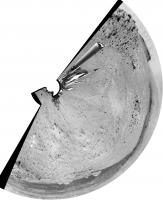
A good drive brings us out a bit south of the prominent hill below the last position. Map update tomorrow.
Phil
-------------------- ... because the Solar System ain't gonna map itself.
Also to be found posting similar content on https://mastodon.social/@PhilStooke Maps for download (free PD: https://upload.wikimedia.org/wikipedia/comm...Cartography.pdf NOTE: everything created by me which I post on UMSF is considered to be in the public domain (NOT CC, public domain) |
|
|
|
|
|
|
Mar 13 2014, 10:02 AM
Post
#714
|
|
|
Senior Member Group: Members Posts: 1619 Joined: 12-February 06 From: Bergerac - FR Member No.: 678 |
Sol 568 Navcam pan
-------------------- |
|
|
|
|
Mar 13 2014, 06:25 PM
Post
#715
|
|
 Member Group: Members Posts: 404 Joined: 5-January 10 Member No.: 5161 |
A quick mini-animation from Sol 568 Navcam. The turn shows up nicely. Covering some ground!
 |
|
|
|
|
Mar 14 2014, 12:02 AM
Post
#716
|
|
|
Member Group: Members Posts: 201 Joined: 16-December 13 Member No.: 7067 |
Thar she blows! Although we had seen the dark rocks a few valleys back
 Stretched version Thumbnail version of the drive because I have the feeling we'll be waiting a while to fill in all the images. Almost time for a breather. Any bets on how long we stay? |
|
|
|
|
Mar 14 2014, 07:35 AM
Post
#717
|
|
|
Member Group: Members Posts: 404 Joined: 5-January 10 Member No.: 5161 |
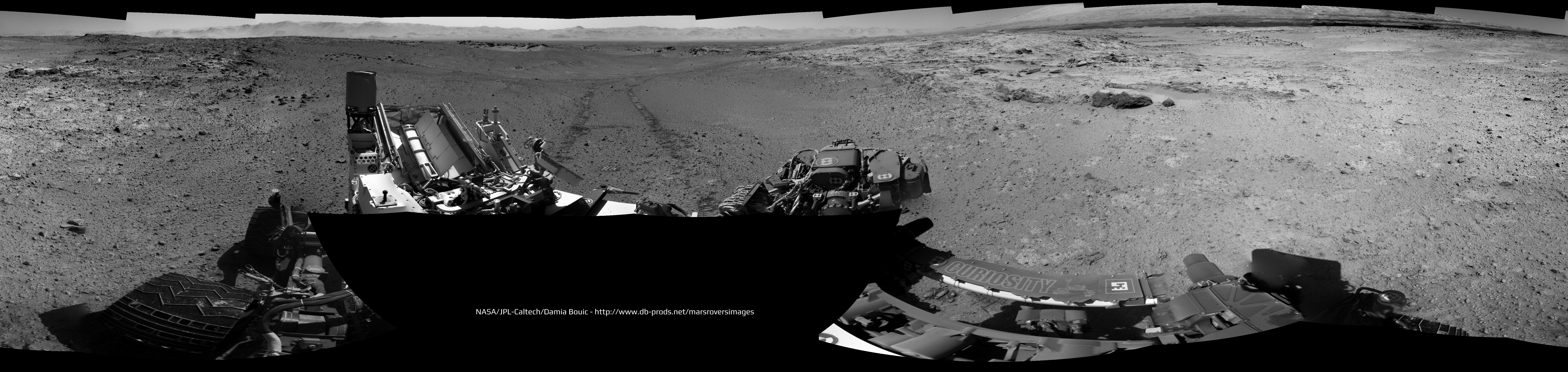
My take on this nice drive sequence from sol 569:

|
|
|
|
|
Mar 14 2014, 09:16 AM
Post
#718
|
|
|
Senior Member Group: Members Posts: 1619 Joined: 12-February 06 From: Bergerac - FR Member No.: 678 |
Sol 569 Navcam panoramic.

-------------------- |
|
|
|
|
Mar 14 2014, 09:22 AM
Post
#719
|
|
|
Member Group: Members Posts: 809 Joined: 3-June 04 From: Brittany, France Member No.: 79 |
Panorama taken on sol 568 with MastCam 34mm:
 And in false colors with contrast stretched: 
-------------------- |
|
|
|
|
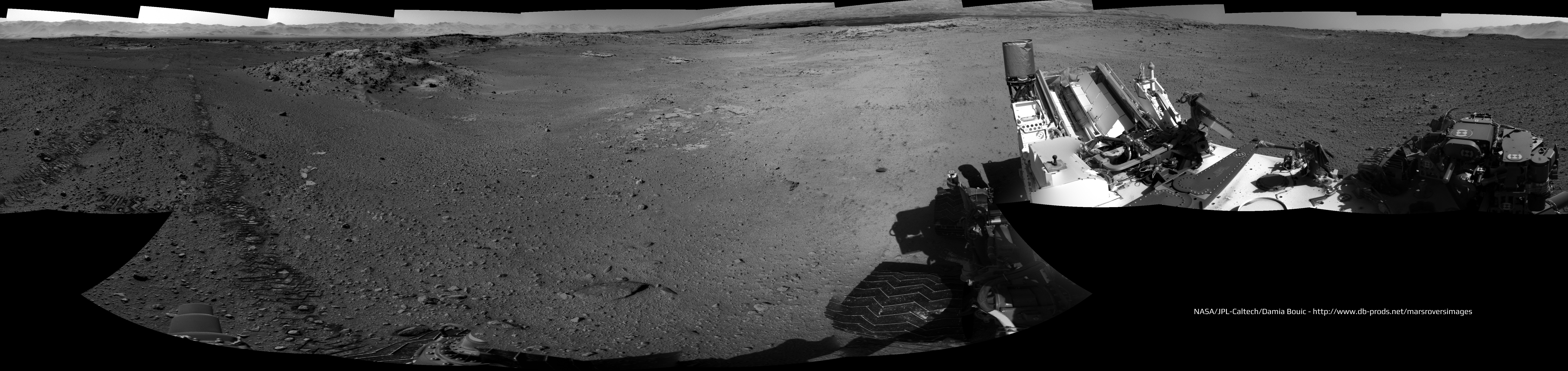
Mar 14 2014, 01:43 PM
Post
#720
|
||
|
Solar System Cartographer Group: Members Posts: 10151 Joined: 5-April 05 From: Canada Member No.: 227 |
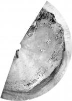
This is Damia's sol 569 panorama in circular form:
Phil -------------------- ... because the Solar System ain't gonna map itself.
Also to be found posting similar content on https://mastodon.social/@PhilStooke Maps for download (free PD: https://upload.wikimedia.org/wikipedia/comm...Cartography.pdf NOTE: everything created by me which I post on UMSF is considered to be in the public domain (NOT CC, public domain) |
|
|
|
|
|
|

|
Lo-Fi Version | Time is now: 25th April 2024 - 11:36 AM |
|
RULES AND GUIDELINES Please read the Forum Rules and Guidelines before posting. IMAGE COPYRIGHT |
OPINIONS AND MODERATION Opinions expressed on UnmannedSpaceflight.com are those of the individual posters and do not necessarily reflect the opinions of UnmannedSpaceflight.com or The Planetary Society. The all-volunteer UnmannedSpaceflight.com moderation team is wholly independent of The Planetary Society. The Planetary Society has no influence over decisions made by the UnmannedSpaceflight.com moderators. |
SUPPORT THE FORUM Unmannedspaceflight.com is funded by the Planetary Society. Please consider supporting our work and many other projects by donating to the Society or becoming a member. |
|