Perseverance Lands In Jezero Crater, Sol 0-14 |

  |
Perseverance Lands In Jezero Crater, Sol 0-14 |
 Feb 18 2021, 09:48 PM Feb 18 2021, 09:48 PM
Post
#31
|
|
 Newbie  Group: Members Posts: 18 Joined: 19-September 13 Member No.: 7005 |
The plume crash plume in the MSL photo is on/over the horizon. The apparent dust cloud in the Perseverance image appears closer than the horizon.
|
 |
 
|
|
Feb 18 2021, 09:52 PM
Post
#32
|
|
|
Junior Member Group: Members Posts: 88 Joined: 8-May 14 Member No.: 7185 |
Yes, with the dust-cloud well below the horizon on such a wide-angle view it must be very close.
Remember the first Oppy hazcam shots. We thought they showed a huge outcrop. Turns out it was just a few centimeters high. |
|
|
|
|
Feb 18 2021, 09:53 PM
Post
#33
|
|
 Junior Member Group: Members Posts: 50 Joined: 14-January 07 From: France Member No.: 1602 |
|
|
|
|
|
Feb 18 2021, 10:03 PM
Post
#34
|
|||
 Senior Member Group: Members Posts: 1417 Joined: 26-July 08 Member No.: 4270 |
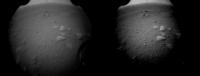
Using the images from MERovingian's link and increasing the contrast, it is clear that the feature is at/over the local horizon.
Attached thumbnail(s)
-------------------- -- Hungry4info (Sirius_Alpha)
|
||
|
|
|
||
|
Feb 18 2021, 10:07 PM
Post
#35
|
|
|
Member Group: Members Posts: 866 Joined: 15-March 05 From: Santa Cruz, CA Member No.: 196 |
Such a great start! the new landing system spoiled us with what seems to be perfect placement, so the interactive ESA Jezero map may not even need to relocate their 'Perseverance landing site' pin.. to get the probable skycrane crash plume in just the second downlinked image is more icing on the cake and hopefully there will be more frames to help determine how quickly the plume settles, and not to mention congrats to JPL on returning that meteorite fragment to its original home!
|
|
|
|
|
Feb 18 2021, 10:08 PM
Post
#36
|
||
|
Senior Member Group: Members Posts: 2917 Joined: 14-February 06 From: Very close to the Pyrénées Mountains (France) Member No.: 682 |
This one looks better
-------------------- |
|
|
|
|
|
|
Feb 18 2021, 10:10 PM
Post
#37
|
||
 Senior Member Group: Moderator Posts: 2262 Joined: 9-February 04 From: Melbourne - Oz Member No.: 16 |
Only one partial that is not a thumbnail. Cropped, curves adjusted and enlarged 200%
Attached thumbnail(s)
-------------------- |
|
|
|
|
|
|
Feb 18 2021, 10:13 PM
Post
#38
|
|
|
Senior Member Group: Members Posts: 2917 Joined: 14-February 06 From: Very close to the Pyrénées Mountains (France) Member No.: 682 |
Post landing conference scheduled at 22h30 UTC in another 15 minutes or so
-------------------- |
|
|
|
|
Feb 18 2021, 10:22 PM
Post
#39
|
|
 Member Group: Members Posts: 443 Joined: 1-July 05 From: New York City Member No.: 424 |
I guess there will always be an essential similarity to the immediate vicinity of safe landing sites...

|
|
|
|
|
Feb 18 2021, 10:27 PM
Post
#40
|
||
|
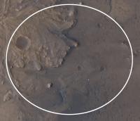
Senior Member Group: Members Posts: 1417 Joined: 26-July 08 Member No.: 4270 |
The landing site is likely the white dot. I suspect the "top" horizon in the Rear HazCam images is probably the cliff that defines the delta.
Attached thumbnail(s)
-------------------- -- Hungry4info (Sirius_Alpha)
|
|
|
|
|
|
|
Feb 18 2021, 10:37 PM
Post
#41
|
|
|
Member Group: Members Posts: 156 Joined: 22-May 09 From: Ireland Member No.: 4792 |
Super achievement...congrats to you Mars's guys and team (would love to be involved in its future exploration).
John |
|
|
|
|
Feb 18 2021, 10:38 PM
Post
#42
|
||
|
Senior Member Group: Members Posts: 2917 Joined: 14-February 06 From: Very close to the Pyrénées Mountains (France) Member No.: 682 |
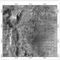
This would be in Canyon de Chelly square
-------------------- |
|
|
|
|
|
|
Feb 18 2021, 10:39 PM
Post
#43
|
|
|
Solar System Cartographer Group: Members Posts: 10145 Joined: 5-April 05 From: Canada Member No.: 227 |
I'd rather not if you don't mind. Mapping from beyond the grave is not on my bucket list.
EDIT: Darn.. the post I was joking about has been changed! . Phil -------------------- ... because the Solar System ain't gonna map itself.
Also to be found posting similar content on https://mastodon.social/@PhilStooke NOTE: everything created by me which I post on UMSF is considered to be in the public domain (NOT CC, public domain) |
|
|
|
|
Feb 18 2021, 10:41 PM
Post
#44
|
|
|
Member Group: Members Posts: 306 Joined: 4-October 14 Member No.: 7273 |
QUOTE (Hungry4info @ Feb 18 2021, 04:27 PM)  The landing site is likely the white dot. I suspect the "top" horizon in the Rear HazCam images is probably the cliff that defines the delta. That's my estimate from a hazard map I saw on NASA's livestream. My sources on the mission team have told me that I'm probably within 100 m of the actual landing site (about the width of the dot in all directions), but they're still in the process of refining the position from thumbnails and HiRISE DTMs, probably won't know for sure until data comes down from an MRO pass this evening. Looks like a good early traverse ahead! We're on the edge of the mafic floor unit, the etched floor unit is only a few days' drive away (probably doable within a day if the Ops team really wanted to move that quickly), and a relatively big crater where the rover can look deep into the crater floor materials with only a short detour. |
|
|
|
|
Feb 18 2021, 10:41 PM
Post
#45
|
||
|
Member Group: Members Posts: 808 Joined: 10-October 06 From: Maynard Mass USA Member No.: 1241 |
My take on the non-thumbnail-partial image...
-------------------- CLA CLL
|
|
|
|
|
|
|

|
Lo-Fi Version | Time is now: 17th April 2024 - 03:23 AM |
|
RULES AND GUIDELINES Please read the Forum Rules and Guidelines before posting. IMAGE COPYRIGHT |
OPINIONS AND MODERATION Opinions expressed on UnmannedSpaceflight.com are those of the individual posters and do not necessarily reflect the opinions of UnmannedSpaceflight.com or The Planetary Society. The all-volunteer UnmannedSpaceflight.com moderation team is wholly independent of The Planetary Society. The Planetary Society has no influence over decisions made by the UnmannedSpaceflight.com moderators. |
SUPPORT THE FORUM Unmannedspaceflight.com is funded by the Planetary Society. Please consider supporting our work and many other projects by donating to the Society or becoming a member. |
|