Printable Version of Topic
Click here to view this topic in its original format
Unmanned Spaceflight.com _ MRO 2005 _ High-Res DEMs from single HiRISE images
Posted by: Nirgal Jan 16 2010, 03:30 PM
Hi all,
Here the long overdue continuation of the "Alien Landscapes" series. This time based on 3D
DEMs generated with "Shape from Shading" from single HiRISE images.
Enjoy 
Click on Images for larger version.
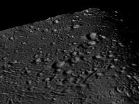
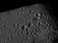
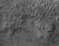
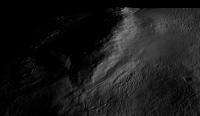
Detail views from PSP_002172_1410 (large gully system)
http://www.thethirdplanet.de/mars_gallery/preview/sfs/Image1.jpg
http://www.thethirdplanet.de/mars_gallery/preview/sfs/Image4.jpg
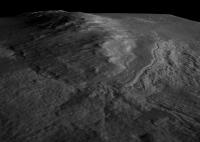
Detail view of Gullies from PSP_001376_1675
http://www.thethirdplanet.de/mars_gallery/preview/sfs/Image2.jpg
http://www.thethirdplanet.de/mars_gallery/preview/sfs/Image6.jpg
Detail of gully system in PSP_002022_1455
http://www.thethirdplanet.de/mars_gallery/preview/sfs/Image7.jpg
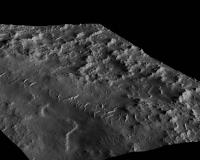
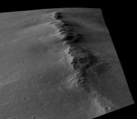
Dune Views from PSP_004339_1890
http://www.thethirdplanet.de/mars_gallery/preview/sfs/Image8.jpg
http://www.thethirdplanet.de/mars_gallery/preview/sfs/Image9.jpg
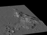
Detail from PSP_001834_1605
http://www.thethirdplanet.de/mars_gallery/preview/sfs/Image11.jpg
http://www.thethirdplanet.de/mars_gallery/preview/sfs/Image13.jpg
Here is some background info on the making of the images:
"Shape from Shading" (SFS) i.e. the possibility to extract shape information from a single image has always been a fascinating topic for me.
Now I found the time to implement a prototype for a new SFS algorithm based on some ideas that I've been thinking about for a long time.
The problem with existing SFS approaches (see http://citeseer.ist.psu.edu/675287.html is that they either tend to over-smooth the details (due to the regularization constraint) or suffer from excessive noise in the high-frequency components of the reconstructed surface. Another problem is the large demand on CPU ressources which would make them very challenging to apply to large scale input data, such as HiRISE orbiter images.
So for a long time I was rather sceptical as to the potential of SFS and it was my impression that Methods based on multiple images (stereo) must be far superior to single-image SFS.
However, after a long time of experimenting, combining existing approaches with some new ideas, I got the following quite promising first results that I'd like to share:
All of the images were generated from a single HiRISE image (no depth information was used from stereo or laser altimeter data).
Also, no texturing or additional coloring/shading was applied when rendering the surface.
Every detail visible is real 3D down to the pixel-level...
For rendering I used a very simple model based on lambertian reflection with gouraud shading.
The resolution of the images is still moderate: that is downsampled details crops in the order of 0.5-1 Megapixels.
However, despite the heavy math machinery that drives the core of the algoritm (several systems of equations with millions of unknowns)
the processing time is still moderate (about 15 Minutes per med-res image, using about 2 Gigs main mem) such that the application to full-res HiRISE images should be possible
The following image shows an example to illustrate the general principle (click to enlarge).
http://www.thethirdplanet.de/mars_gallery/preview/sfs/sokrates_sfs.jpg
On the left hand side the 2D input image (simple noisy JPEG from the Web with unknwon light source direction). On the right hand side shows the recovered 3D surface re-lighted under a different light source direction.
Note that one problem of the current implementation of the algorithm is it's vulnerability to notable distortions in the low frequency components (i.e. large scale variations) of the generated surface. However I'm confident that this can be overcome by an improved version or by adding the large-scale depth information from stereo-based DEMs or altimeter data (MOLA) where available.
Posted by: lyford Jan 16 2010, 04:29 PM
WOAH! 
I want to climb those dunes..... amazing!
Posted by: mhoward Jan 16 2010, 05:03 PM
Mind-blowing. 
Posted by: cbcnasa Jan 16 2010, 05:48 PM
The images are just amazing, fantastic job.
Posted by: jamescanvin Jan 16 2010, 06:05 PM
Those are just astonishing Bernhard, great work!
Posted by: ElkGroveDan Jan 16 2010, 06:39 PM
Amazing and beautiful stuff, as always. I don't know about everyone else but my mind is spinning as I ponder the implications of this process. I can see demand for a self-contained software product for this process, or at least a plug-in for one of the popular 3-D utilities.
Posted by: eoincampbell Jan 16 2010, 07:13 PM
Another UMSF classic, it's truly a joy to come here and view this wonderful work,
thanks for posting that...
Posted by: PDP8E Jan 16 2010, 07:43 PM
Bernhard,
This is fabulous progress report!
I hope to see you write this up in a journal soon. The images are stunning
(I look forward to the day I can use your technique!) Cheers
Posted by: djellison Jan 16 2010, 08:20 PM
O
M
F
G
Posted by: Tesheiner Jan 16 2010, 08:36 PM
Unbelievable!!!
I want to climb one of those hills.
Posted by: Bjorn Jonsson Jan 16 2010, 09:09 PM
In a word:
WOW!!!
Are you draping the original image over the DEM or is the DEM itself this detailed?
Posted by: Reckless Jan 16 2010, 09:25 PM
Brilliant Bernhard
As I was looking at those pictures I was wondering what Doug would think of them... then he posted.
Nuff said.
Roy
Posted by: nprev Jan 16 2010, 09:32 PM
Just freakin' amazing, is all! What immediacy these images have.
Posted by: Nirgal Jan 16 2010, 10:27 PM

WOW!!!
Are you draping the original image over the DEM or is the DEM itself this detailed?
There is no texture mapping or smoothing involved: every pixel is real 3D - The DEM itself is detailed down to the single pixel level.
That's the really interesting thing with this new techinque: The absence of the strong smoothing process that gives many conventional DEM-images that somewhat "washed", unnaturally soft appearance.
(however: while it works perfectly for the higher frequency bands, there can be distortions in the lower frequency components ...
so the DEMs in their current form could probably not be used for exact inference about variations of absolute terrain heights over larger scales (that's where MOLA and conventional stereo based techniques have advantages: so it seems natural to combine the techniques) ...
P.S.: I also forgot to mention that in most images the vertical scale is exaggerated by a factor of about 1.5 to 2.
Posted by: Stu Jan 16 2010, 10:29 PM
Can your amazing new process create renders with no vertical exaggeration? I'd love to see those!
Posted by: ngunn Jan 16 2010, 10:49 PM
Me too. I always prefer to see landscapes without the 'victorian-painter-in-the-highlands' effect. Very nice work tho.
Posted by: Bjorn Jonsson Jan 16 2010, 11:07 PM
I suspected this from the first message but wanted to be sure. This makes this DEM even more amazing.
(however: while it works perfectly for the higher frequency bands, there can be distortions in the lower frequency components ...
so the DEMs in their current form could probably not be used for exact inference about variations of absolute terrain heights over larger scales (that's where MOLA and conventional stereo based techniques have advantages: so it seems natural to combine the techniques) ...
It would be really interesting to see DEMs for bodies like Europa and Enceladus. Also I have a global DEM of Rhea so a comparison to my results there would be interesting. As you mentioned a DEM from your software would be far more detailed than mine but low frequency variations would be less accurate (combining results from these two approaches might be interesting for big impact basins like Tirawa).
Posted by: Nirgal Jan 16 2010, 11:16 PM
It would be really interesting to see DEMs for bodies like Europa and Enceladus. Also I have a global DEM of Rhea so a comparison to my results there would be interesting. As you mentioned a DEM from your software would be far more detailed than mine but low frequency variations would be less accurate (combining results from these two approaches might be interesting for big impact basins like Tirawa).
Thanks Björn,
i too am interested in combing the various DEM approaches but at the moment, unfortunately lacking the time (still working on the improvement to the single-image SFS method)
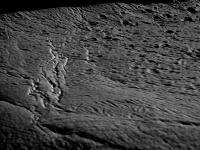
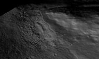
here is another image (a close up of gully wall) that illustrates the high detail preservation (it's not even rendered at full resolution)
(click for larger version)
http://www.thethirdplanet.de/mars_gallery/preview/sfs/Image14.jpg
And for Stu and and ngunn: no vertical (i.e. profile) exaggeration this time :-)
Posted by: nprev Jan 16 2010, 11:26 PM
...how sedimentary can you get?
Posted by: ngunn Jan 17 2010, 10:18 AM
Excellent! Now I can make an informed choice of footwear.
Please excuse a very basic question. If these are made from single images how do you prevent albedo differences from masquerading as relief?
Posted by: Nirgal Jan 17 2010, 12:25 PM
Please excuse a very basic question. If these are made from single images how do you prevent albedo differences from masquerading as relief?
of course there is no general solution to deal with varying albedo in "shape-from-single-image", because, as you pointed out, any difference in luminance will be interpreted as difference in local surface orientation. (The same problem also occurs for cast shadows that will be interpreted just as flat areas)
However, experience shows that the underlying assumption of constant albedo works surprisingly well for large parts of the martian surface where there is very little variance in surface color and albedo.
Furthermore, the general idea with the SFS approach is to incorporate additional depth information from stereo or altimeter based measurements, so those techniques nicely complement each other
Posted by: djellison Jan 17 2010, 03:14 PM
If you want a good test - try the Pathfinder observations
Posted by: ElkGroveDan Jan 17 2010, 06:09 PM
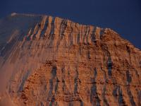
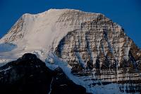
And for an Earthly analog here is the http://images.google.com/images?hl=en&safe=off&rlz=1B3GGGL_en___US343&um=1&sa=1&q=Mount+Robson+Emperor+Face&aq=f&oq=&aqi=&start=0, the highest peak in the Canadian Rockies. (If it's anything similar Nigel I wouldn't just worry about what you are wearing on your feet but which implements you are carrying in your hands as well.)
|
|
Posted by: imipak Jan 17 2010, 07:17 PM
...what everyone else has said!
I know very little of the field, but isn't this somewhat ground-breaking, revolutionary work that will have significant applications, like, all over the place? Including earth observations? (As a somewhat random example, there's an appeal out for high-res DEMs of Haiti : http://www.boingboing.net/2010/01/15/haiti-news-roundup-n.html#comment-688501 )
Forgive a lay-person's question: would it be possible to drape a texture map or surface image over the DEM, without it looking really ugly and pixellated in places?
Ah, that's just what I was wondering; those dunes looked a little steep.
Posted by: Nirgal Jan 18 2010, 10:26 AM
I know very little of the field, but isn't this somewhat ground-breaking, revolutionary work that will have significant applications, like, all over the place? Including earth observations?
I would not use such big words like "revolutionary" (this would be waaay too much honor
 )
) The field of single-image "Shape-from-Shading" (SfS) has been a classical area of computer vision since the 1970s (in the planetary science community also known under the name photoclinometry) and it has also been widely applied already for planetary data sets. See for example the seminal work done by http://astrogeology.usgs.gov/About/People/RandolphKirk/ of USGS in the field.
Among other notable applications, SfS/photoclinometric methods based on MGS/MOC imagery were involved with the MER landing site selections.
For a general survey on the field, see for example http://www.google.de/url?sa=t&source=web&ct=res&cd=1&ved=0CAkQFjAA&url=http%3A%2F%2Fwww.cs.ucf.edu%2F~vision%2Fpapers%2Fshah%2F99%2FZTCS99.pdf&rct=j&q=tasi+survey+shape+from+shading&ei=8jJUS8_UOYfymwOWstyaCg&usg=AFQjCNHFJhMbHizNpV5yXQ6geVgAajq2CA
The current new method that I'm experimenting with at the moment, does seem to have the potential to improve on existing approaches in particular with respect to the better preserving of high frequency (i.e. detail) variations, whereas on the other hand it too suffers from some of the (fundamental) problems inherent to any single-image method, namely the constant-albedo, shadows, convex-concave-ambiguity, low-frequency distortions to name a few (thats were it could be complemented with the already mentiond combination with stereo- and altimeter-based methods )
However, at this time I'm at a very early stage of experimenting and it's way too early for a final conclusive judgment. I just wanted to share the first results, because I for myself was surprised that they came out rather promising. But there is still a lot of work to do before any definite conclusions can be drawn.
Its more of an evolutionary than revolutionary process
Posted by: Nirgal Jan 18 2010, 01:15 PM
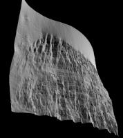
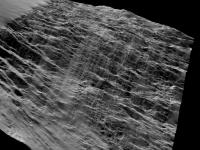
just for fun (and comparison with the Mars DEMs): here is a quick try of the SFS method to the earthly Mt. Robson (unoptimized low-res, just from the noisy JPEG image as attached to ElkroveDan's post above)
Here are some views of the resulting 3D DEM:
|
|
Posted by: vikingmars Jan 18 2010, 02:49 PM
Bernhard, your work is "estupendo" ! "Stupéfiant" ! Brilliant ! ...I'm just lacking of words to express my enthusiasm about what you did.
BRAVO !
Posted by: sgendreau Jan 18 2010, 04:27 PM
) I just wanted to share the first results, because I for myself was surprised that they came out rather promising. But there is still a lot of work to do before any definite conclusions can be drawn.You are waaay too modest -- these are extraordinary. I never expected to hover off a martian crater wall in a helicopter.
Posted by: climber Jan 18 2010, 05:20 PM
Bernhard, after Olivier's statement, knowing what he does himself, I only can add: "Salut l'Artiste".
Posted by: PDP8E Jan 18 2010, 08:42 PM
Bernhard,
What could your technique do with a fairly bland area, such as Meridiani?
Would you be able to discern the small rise that fresh crater (conception) sits upon? Cheers
Posted by: Bjorn Jonsson Jan 19 2010, 01:00 AM
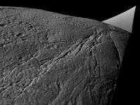
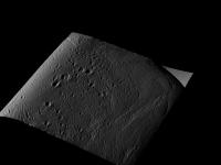
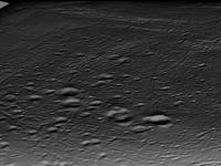
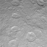
Earlier in this thread I mentioned Enceladus and Europa. If it's not too much work I would be very interested in seeing what a DEM of the attached image of Enceladus looks like. I have a DEM for a fairly big part of it (not near the bottom though) so a comparison would be interesting.
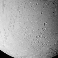
|
Posted by: Nirgal Jan 19 2010, 03:43 PM
ok, no problem: here I generated some views of it in 3D
|
|
|
|
|
|
P.S.: one nice thing about the algorithm is that one does not need to specify any external calibration parameters, like the light source (sun incidence and azimut) direction.( because those are estimated simultaneously with the recoverered 3D surface )
So it can be applied to any arbitrary 2D image without knowledge about the exact viewing conditions.
Posted by: djellison Jan 19 2010, 04:19 PM
OK - yeah - do you think you'll be able to share the software and technique at some point? I have enough ideas for this that would keep you on your toes till April
Posted by: Bjorn Jonsson Jan 19 2010, 05:37 PM
*Jaw drops to the floor*

This is awesome, probably the most interesting UMSF-member-developed software I have seen in the history of UMSF so I can simply repeat what Doug said above (actually I could probably keep you busy till April *next* year or longer ;-). If I could combine output from SFS with the output from my steromatcher I'd get DEMs of probably something like 10 times higher resolution than I have ever dreamt of. Combining DEMs like this is probably not difficult. If you manage to get this to work the way you want to there are lots of people here who would love to test it.
And I would make my stereomatcher available - would need to spruce it up a lot though and it still has some bugs and quirks. Combining results from these two approaches opens up *lots* of possibilities. In particular, the low frequency variations from my software are pretty accurate (how accurate depends largely on how accurate the viewing geometry information is) while high frequency details are a problem and frequently 'disappear'.
In contrast my stereomatcher needs accurate viewing geometry information, field of view etc. Inaccurate viewing geometry information typically manifests itself as a 'tilted' DEM.
Posted by: djellison Jan 19 2010, 05:47 PM
Things I want to try ( in no particular order )
Topography of rocks using MER MI and Pancam imagery
Height maps of MER sites using vertical projection mosaics
Produce DEM's from HiRISE of the Mars Pathfinder landing site, and the full Opportunity site ( from Eagle all the way to Victoria ) as well as Phoenix and Viking sites
Posted by: mcaplinger Jan 19 2010, 06:23 PM
Not to be dismissive of this, but as Nirgal pointed out himself, SFS/photoclinometry has been used in the planetary science community for a long time but just isn't very accurate in a lot of cases. While it may be sufficient for pretty visualizations, do you have any sense for how truly accurate your algorithm is?
Posted by: ElkGroveDan Jan 19 2010, 06:38 PM
Since we have a lot of examples of places with very detailed and accurate DEMs it would be interesting to try this process on single images of those areas and compare the two methods. Columbia Hills comes to mind. I think we have flyover DEM of that around here somewhere
Posted by: Nirgal Jan 19 2010, 09:27 PM
That's right: the main application of the algorithm (at least in its current form) is clearly the area of plausible visualization in near-photorealistic image resolution. (and that's the application that I'm personally most interested in)
In this area it seems to be a very interesting tool to visually explore and display the huge space imaging datasets, particularly when there is no other 3D cue like altimeter or stereo data available.
The question of actual physical accuracy however, is much more difficult to answer.
In this regard, there are clear limitations to any shape-from-single-image methodology as already pointed out.
This is where the already mentioned combination with low-res but more accurate data (altimeter, stereo) comes into play ...
So in summary: yes, this project (in its current state) is intended primarily as a means of visualization, not so much as a scientific measuring instrument (of which there are already many other and better possibilities).
For me, it has been an old childhood dream to literally "wander into" and "bring to live" the images that were sent back by our space probes ... images to fuel the imagination of space exploration
Posted by: Ant103 Jan 19 2010, 09:30 PM
ASTOUNDING ! AMAZING ! You just did a WONDERFUL work Nirgal
Absolument magnifique !
I want to view more about that
Posted by: Stu Jan 19 2010, 09:35 PM
You keep sharing your "pretty visualisations" Nirgal; 1000% accurate or not, we're all loving them!
I have a list of requests too, but they'll keep. I'm sure there's a queue! 
Posted by: Bjorn Jonsson Jan 19 2010, 11:05 PM
There are lots and lots of things I'd be interested in testing but I'm posting just a single image to test if it's not too much trouble. What I'm posting here has been carefully selected to ensure I shouldn't have to post more stuff to test, at least not in the near term (although testing how the SFS software performs with the sun almost directly overhead would be interesting as well, my stereomatcher performs poorly in that case for obvious reasons).
This is a Cassini image of Rhea with the Tirawa impact basin partially visible in the upper right quadrant:
|
I would be very interested in seeing a DEM from this image. What would be most interesting, if possible, would be a 1024x1024 pixel 16 bit grayscale DEM as a tiff or png file. If this is possible I'll attempt to merge it into my global DEM of Rhea that I made using stereo pairs. That would combine the best of both worlds and I would post the results here. Otherwise some test renders would be nice.
This is a portion of my DEM of Rhea showing most of the image above (it's slightly cropped):
|
Here black represents -6.320 km and white 6.176 km relative to an ellipsoid. Unlike the Cassini image above, this 'image' is in simple cylindrical projection and covers longitude 150.25 to 187.875 degrees and latitude 8.625 to 41.625 degrees (including the black stuff surrounding the DEM).
Posted by: vikingmars Jan 20 2010, 08:37 AM
Topography of rocks using MER MI and Pancam imagery
Height maps of MER sites using vertical projection mosaics
Produce DEM's from HiRISE of the Mars Pathfinder landing site, and the full Opportunity site ( from Eagle all the way to Victoria ) as well as Phoenix and Viking sites
Exactly the same needs for me !
=> Is your software working also on a Windows environment (to be more easily carried on a portable home computer when travelling) ?
Bravo ! Encore !

Posted by: 4th rock from the sun Jan 20 2010, 10:09 AM
I'd VERY much like to produce a detailed DEM from the Magellan Venus radar images, such as Maxwell Montes: http://photojournal.jpl.nasa.gov/catalog/PIA00149
I think that small scale topography could be recovered by SFS / photoclinometry algorithms and integrated into the low resolutions altimetry data we already have. That would reduce artifacts introduced by surface "albedo" changes, as we would only be recovering small scale local terrain features. Anyone tried something like it?
Posted by: djellison Jan 20 2010, 01:56 PM
I'm not sure this would work on Radar.
Posted by: 4th rock from the sun Jan 20 2010, 02:13 PM
It should work on radar, as there's the concept of "radar illumination".
See here: http://www.ccrs.nrcan.gc.ca/glossary/index_e.php?id=2844
Of course, having the "light" coming from an orbiting (moving) spacecraft is not the same as from a single distant light source, but you still have higher or lower reflections according to the surface angle. So in theory you could recover some information from those radar images, at least better than the global altimetry we have.
Posted by: mcaplinger Jan 20 2010, 02:19 PM
On the Magellan project this was known as "radarclinometry" (do a google search.) It didn't work all that well IIRC.
More recent applications are described in http://www.lpi.usra.edu/meetings/lpsc2009/pdf/1071.pdf
Posted by: imipak Jan 20 2010, 02:42 PM
*cough* Titan..? (Edit - sorry, I didn't spot Mcaplinger's post before posting.)
Also, I wonder if hidden craters like Scamander might show up at Gusev?
Posted by: elakdawalla Jan 20 2010, 07:30 PM
The software wouldn't work on radar images without some rewriting, because foreshortening of topography works oppositely between radar and visible imaging. In radar, high-elevation things are closer to the spacecraft than low-elevation things, so their echoes are received earlier, so mountain peaks are apparently displaced toward the spacecraft rather than away from it as they are with visible images.
Mcaplinger: Although I think you're right that radarclinometry wasn't as effective as photoclinometry on, say, Viking or LO images, I think in many cases it was better than the quality of the Magellan altimetric data. I worked really closely with that altimetric data and over any place where there was any significant topography its quality was really poor, with lots of blatantly incorrect elevations, great big holes represented by one altimetric footprint in the middle of ridges and the like. Apparently Peter Ford's group developed an improved version of the global topographic map internally, correcting some of these issues, but as far as I know it has never been published.
Posted by: mcaplinger Jan 20 2010, 07:56 PM
When I was working on Magellan we were using radar stereogrammetry (see http://www.lpi.usra.edu/meetings/lpsc2009/pdf/1253.pdf for some recent work.) Stereogrammetry is always preferred to photoclinometry if stereo is available.
Posted by: vikingmars Jan 20 2010, 08:38 PM
Bernhard, just an idea...
Because this 3D HI-Res DEM rendere is a huge work of yours that is to be acknowledged, what if you share your software to UMSF members versus a financial participation (or a donation) ?
Posted by: 4th rock from the sun Jan 20 2010, 08:43 PM
Thanks for sharing your insights into the photoclinometry from radar images. It's one of those things that seems obvious at first but is quite the opposite. At least I learned something!
Posted by: Nirgal Jan 20 2010, 09:30 PM
Because this 3D HI-Res DEM rendere is a huge work of yours that is to be acknowledged, what if you share your software to UMSF members versus a financial participation (or a donation) ?
Thank you all so much for all the nice words and suggestions !
At this time, the project is unfortunately not yet ready to be officially released in any publicly useable way for several reasons. First, it is still in a very early stage of development and I have just begun to explore the possibilities and there are a lot of ideas for improvement that I would like to try out, many bugs to be fixed etc.
Also, there are technical and license related obstacles : for example I am using a large collection of self written and third-party C/C++ APIs and libraries that I developed and collected over the past 15 years.
While some of them are open source, there are also commercial or closed source libraries that would have to be completely re-written first. (this task alone would be a several-years project I'm afraid)
And most importantly, there is no such thing like a GUI or comfortable user interface. The whole project is more like an experimenting platform consisting of a complex & ugly command line interface, a cryptic shell language and about 2000 tuning parameters ...
Also, I am doing this all in my spare time only, as a means of recreation and relaxation ...
And for me it is simply much more fun to explore and implement interesting algorithms without taking care to write clean and robust user interfaces, doing customer support or the like (this is what I have to do in my profession as software developer all the time
Finally I view my software projects mainly as tools, i.e. the means for creating atmospheric images and it is those images that are the real "publishable end product" of the whole process. The algorithms and software are just the "painters brush and easel" or the photographer's camera so to speak.
So at the very least I will continue to publish those images on a regular basis ... maybe I even find the time to setup a Web Gallery or Blog for that purpose.

Posted by: Bjorn Jonsson Jan 21 2010, 12:56 AM
As should already be obvious I'm very interested in this so there are some things I'm curious about. From the examples posted it looks as if something like this might revolutionize the quality and resolution of my stereo derived DEMs where the low frequencey stuff is already reasonably accurate. I have already figured out how I would combine stereo DEMs and SFS DEMs.
While some of them are open source, there are also commercial or closed source libraries that would have to be completely re-written first. (this task alone would be a several-years project I'm afraid)
Is this (commercial/closed source libraries) a problem because it's explicitly forbidden to distribute software based on them or is the problem licence costs or stuff like that? Vikingmars' idea (donations) is interesting and the reason I ask. There's nothing that says the software must be freeware if you make it available one day (and obviously that wouldn't work at all if library licence costs are an issue).
How important this is depends on the 'type' of users. Almost all of my software is command line utilities, including the stereo software - doing a nice GUI is a waste of precious time ;-). For lots of users this might be a problem though.
Now this is something familiar (and lack of time is too ;-)).
I should add that despite the questions/comments above I'm not surprised you are not interested in immediately releasing this. My stereo software is in a similar state as far is this is concerned - it works but there are some bugs and quirks I know of. For example it currently works only for images from framing cameras - using pushbroom source images would probably result in distorted DEMs (I haven't tried it though).
Posted by: climber Jan 21 2010, 10:07 PM
I'm wondering if you (Bernhard) can run your software on the picture included here: http://www.lpi.usra.edu/meetings/lpsc2010/pdf/2638.pdf from Phil's post regarding Oppy traverse.
Seing some relief and visualizing what will be seen once at the "hell of a view" point, in another 2 kms, will surely be very much appreciated here.
Let us know.
Thanks
Posted by: Phil Stooke Jan 22 2010, 12:32 PM
It can't be done on that image, it would have to be on the original CTX or HiRISE images.
But of course, seeing these great results for the Columbia Hills or Endeavour crater would be very much appreciated!
Phil
Posted by: Nirgal Jan 22 2010, 03:40 PM
Phil
I have been thinking about that, too. Do you have the HiRISE/CTX observation IDs for the best/highest resolution images of this areas ?
(I could not find them in the mentioned paper)
Posted by: djellison Jan 22 2010, 03:59 PM
Two for the columbia hills are listed within this DTM
http://hirise.lpl.arizona.edu/dtm/dtm.php?ID=PSP_001513_1655
Posted by: Nirgal Jan 23 2010, 04:00 PM
http://hirise.lpl.arizona.edu/dtm/dtm.php?ID=PSP_001513_1655
Ah, thanks. Here is a quick try with my single-image-SFS-DEM at a 3D zoom into the Columbia-Hills HiRISE image linked above:
2D version (at maximum HiRISE resolution)
|
Generated 3D version (with approx. 3 millions of shaded polygons)
|
Note that the above image is for visualization only. There may be distortions in the map caused by albedo differences (due to dust coverage patterns, for example ) that the single-image algorithm can not resolve.
The original recently published HiRISE DTMs of which I also rendered a qick visualisation (over a larger area)
|
are much more accurate with respect to the mid and large scale height variations.
Still, for visualization purposes I like the high-resolution detail, almost photographic look of the single-image based DEMs
(It's a lot of fun to be able to "wander-into" the landscape from a single 2D image only
Posted by: ngunn Mar 1 2010, 10:08 PM
Nirgal, I can't find your original thread so I'll add on here. I have a request. Can you work your magic on these features. They are located just inside Endeavour crater and are a possible destination for Opportunity. Contour maps seem to bypass them yet they look as if they have some relief:
http://www.unmannedspaceflight.com/index.php?act=attach&type=post&id=16180
Posted by: Nirgal Mar 1 2010, 10:36 PM
Interesting. I will see what can be done with these (although from first glance there seems to be large albedo variations in the terrain)
Do you have the original HiRISE observation ID for the image ? (will be useful for obtaining the viewing parameters needed to optimize the 3D reconstruction process)
Posted by: ngunn Mar 1 2010, 10:57 PM
No I don't, unfortunately. Go to the 'Endeavour crater, and again we shall conquer the remoteness' thread post 105 and following and you will find all I have on this. Others here may be able to help more.
Posted by: Tesheiner Mar 2 2010, 06:52 AM
AFAIK, that's the non-map-projected version of PSP_010341_1775.
Posted by: Nirgal Mar 2 2010, 08:44 PM
Upon a request posed over at the "Dust Avalanche" thread I did a small 3D DEM study of an area near Endeavour Crater based on a single image cropped from PSP_010341_1775.
http://www.thethirdplanet.de/mars_gallery/DEM_PSP_010341_1775/index.htm
Click image to see the whole gallery. The first image shows the DEM rendered from above with the same lighting conditions as the original image so as to give an idea of the accuracy of the 3D reconstruction (note, however, that the accuracy decreases somewhat when the DEM is lit from other than the original lighting direction).
The generated DEM consists of 8192x4096 = 32 million polygons with true 3D (means no texturing) post spacing at full HiRISE resolution (28.6 cm/pixel ).
Here is my usual Disclaimer: the rendered DEMs are intended for visualization only. The absolute heights are not calibrated and there may be distortions due to albedo variations.
Posted by: ngunn Mar 2 2010, 09:03 PM
YES!! Now that is everything I'd hoped for and more. Enormous thanks Nirgal. Can you say if there is vertical exaggeration there, and if so how much? This does indeed look like a most worthy target for Opportunity.
(thanks Tesheiner also for undoing my thread tangle)
Posted by: Tesheiner Mar 2 2010, 09:06 PM
Incredible!
BTW, I think we'll have to save this picture, bookmark this thread / post, and revisit it in about one year to compare it with the "ground truth".
Posted by: Nirgal Mar 2 2010, 09:33 PM
I can not give an exact answer to this one as I do not usually put much effort into calibration of abolute heights (for my visualization purposes it's sufficient that the rendered DEM looks approximately the same as the original 2D image when viewed and illuminated under the same conditions )
Then I do have a switch, called "Z_scale_factor" that I sometimes use to exaggerate (or attenuate) the heights artificially. in this case the factor was 1.3 so there is some exaggeration (just for better emphasis of terrain variation) but moderately so.
Posted by: tdemko Mar 3 2010, 11:15 AM
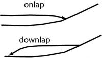
This area has fascinated me for a while and Nirgal's renders have crystallized some of my thoughts. Since I'm a sequence stratigrapher by trade and training (and some say religion...), I look at strata in terms of their geometry (shape and topology of the boundaries) and where and how they terminate. The method of tracking stratal terminations originally comes from interpreting seismic profiles (seismic stratigraphy) where one traces the continuity and termination of reflections. Through this, relative ages, directions of transport, subsidence patterns patterns and other cool things can be determined. Among other types, some of the most obvious stratal terminations include onlap, downlap, and truncation. These little schematic cross sections show the geometry of onlapping and downlapping strata:
|
In the image from Nirgal below, I've highlighted several areas of stratal terminations in one of my (in)famous 5 minute speed interpretations:
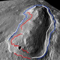
|
red: onlap
blue: downlap
white: truncation by channels
The slightly sinuous channel on the right side of the image does some really cool things, including exiting the terrace region at the top of the image through a v-notched canyon. It suggests the channel is a subsequent geomorphic feature that has incised into previously buried strata as the landscape has been regionally degraded (think Colorado Plateau, Canyonlands, Grand Canyon, etc.). The raised lip of the terrace on the right is also intriguing (due to channel incising?, differential erosion?, etc.)
In general, the hill looks like it was a preexisting topographic feature that was onlapped by several periods of deposition, including the terrace unit which seems to have formed as an apron of downlapping strata that prograded away from the hill (like a shoreline). Subsequent regional landscape degradation has exposed various levels in the stratigraphy which allows us to examine the relative timing and geometry. The degradation has included a channel-incisement phase that has cut through most of the units and has been guided by the differential erodibility of the strata.
Ground truthing these interpretations when Opportunity get here, especially examining the depositional nature of the units and the relative timing of deposition and erosion, is going to be very interesting!
Posted by: ngunn Mar 3 2010, 12:57 PM
Fascinating interpretation there, thanks for sharing. There is one note of caution I'd like to sound in relation to small details of these images - it may be wrong and if so I hope Nirgal will correct me. He himself pointed out that albedo differences could affect his results here. In particular the 'beach terrace' is lighter toned than most of the rest of the scene. I think this might account for its edge looking different on each side of the hill, depending on the original direction of illumination. Funnily enough this difference was the first thing my daughter remarked upon when I showed her the images. Is it real or not? I'm not sure.
I have another question. What is the elevation of the 'beach terrace' and how does it compare with the lowest elevation on the perimeter of Endeavour? I think they're fairly close.
Posted by: ElkGroveDan Mar 3 2010, 02:32 PM
Me too. I've been drooling over it. Thanks Tim for your nice clean interpretation and diagram. A lot of it fits my thinking, though I was scratching my head about that channel on the north end.
Posted by: Floyd Mar 3 2010, 02:33 PM
A question for Tim and Nirgal: This is one of the hills on the western edge of Endeavour? If so, Tim's comment "In general, the hill looks like it was a preexisting topographic feature that was onlapped by several periods of deposition" refers to geologic changes much after formation of the crater? I assume the hill was created by the impact and was not there prior to the impact. Sorry for my confusion.
Posted by: ngunn Mar 3 2010, 02:58 PM
Zoomable CTX of the area:
http://global-data.mars.asu.edu/ctx/img/P01_001414_1780_XI_02S005W
Looks like the next hill to the south has similar features at its northern end (Nirgal??? )
Posted by: Nirgal Mar 3 2010, 03:27 PM
Correct. that's why I usually add my "for visualization purposes only" disclaimer
without knowledge of the true albedo variations, it's difficult to interpret the apparent height variations.
actually it's quite the opposite: the smaller the detail, the better the accuracy of the 3D reconstruction (look at how the small craters and mini dune ripples got reproduced) because albedo variations occur more at larger spatial scales.
That's why the photoclinometric method can nicely complement the mult-image stereo-based methods that are less accurate at the very finest scale (you need features spanning areas of multiple pixels for the point matching algorithm) but are not so easily tricked by albedo variations.
So as mentinoed before: the real potential of the method for scientific usage could only be exploited by combing it with stereo/altimeter based data.
That being said: it is surprising how well the single-image reconstruction often works even in presence of albedo differences and cast shadows (see for example the dark dust steaks over the fine dune ripples in the image posted at the other thread) However, while often working pretty well, there is unfortunately no guarantee so (I have also encountered examples where the albedo problem messed up the 3D reconstruction completely )
I'm sure we will have an official stereo-based HiRISE DEM at 1m/pixel reslution of this area soon.
Then I can try to combine the 1m/pixel stereo-DEM it with my 25cm/pixel photoclinometric DEM to possibly get the best out of both worlds ...
But until then I reiterate my note of caution with respect to scientific/geologic interpretations based on the single-image DEMs that I want to be understood mainly as a means of visualization rtaher than a measurement tool ...
However, it's totally ok and a pleasure for me to see that the visualizations help to spark new and crystalize previously existing ideas... But for such ideas to be finally proven, I think we will need the real ground truth data in the end.
Posted by: Nirgal Mar 3 2010, 06:37 PM
For comparison, here is (a crop of) the original, radiometrically calibrated HiRISE-image I used as input for the 3D reconstruction algorithm (all images at half resolution) A:
|
which yields the following DEM (greylevel = height) B:

|
Now, once I have the DEM I can re-render it under exactly the same illumination conditions (incidence angle, sub-solar azimut etc.) as the original image, which yields this view: C:
|
So comparing A and C gives an idea of the accuracy of the reconstruction process (as can be seen, the so called "photometric error" is almost zero). However, the low photometric error does not tell the whole story because it does not address the albedo variations which can not be resolved from a single image alone without additional information.
The comparison shows, that the reconstruction can be quite exact, at least in the absence of albedo variations...
(The increased contrast in C is due to the higher dynamic range of greylevels used by the 3D renderer compared to the somewhat hazy original image)
Posted by: Julius Mar 3 2010, 07:11 PM
To me it looks like an' island' which eventually got surrounded by lava!Very much like the Columbia Hills in Gusev Crater.So the elevated unit(part of crater rim) should be an older geologic unit compared to the lower areas surrounding it.Any idea as to minerals identified in this unit??
Posted by: Nirgal Mar 4 2010, 08:06 AM
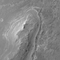
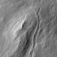
)Yes indeed similar. here are some detail 3D views of the northern end of the next hill to the south.
No vertical exaggeration this time. alternatively I rendered the DEMs with a simulated lower sun angle (i.e. later evening view) than the original in order to pronounce the terrain variations
|
|
|
Here is a "Fly-over-view" from the south (north is up) showing the whole "atoll-like" hill complex:
[attachment=20917:enw4_a.jpg]
|
Posted by: ngunn Mar 4 2010, 09:26 AM
Again, greatly appreciated Nirgal. Those ones show nicely how as it trends north the line of hills dips downward inside the internal crater slope and so will remain out of sight until we get much closer.
Posted by: ngunn Mar 4 2010, 02:19 PM
Nirgal, on closer inspection I'm having trouble with your last image there. Is it left-right inverted?
Posted by: Nirgal Mar 4 2010, 03:57 PM
You are right: somehow the last image got mirror inverted - which is confusing so I changed it. now it's north=up east=right as usual ...
Powered by Invision Power Board (http://www.invisionboard.com)
© Invision Power Services (http://www.invisionpower.com)