Beagle 2 found by MRO/HIRISE. |

  |
Beagle 2 found by MRO/HIRISE. |
 Jan 16 2015, 11:17 PM Jan 16 2015, 11:17 PM
Post
#31
|
|
|
Member  Group: Members Posts: 808 Joined: 10-October 06 From: Maynard Mass USA Member No.: 1241 |
does anyone have the Mars long/lat of Beagle2?
I want to get HiView up and running tonight when I get home Thanks -------------------- CLA CLL
|
 |
 
|
|
Jan 16 2015, 11:17 PM
Post
#32
|
|
|
Founder Group: Chairman Posts: 14434 Joined: 8-February 04 Member No.: 1 |
That'll be the drogue chute flapping about - something like 1.5m across
Lat long - 90.4295E 11.5265N |
|
|
|
|
Jan 17 2015, 01:02 AM
Post
#33
|
|
|
Junior Member Group: Members Posts: 94 Joined: 22-March 06 Member No.: 722 |
Though definitely bittersweet, I consider this more of a triumph than a loss: of the MRO team for finding it, and most of all of Beagle 2 just making it to the surface. When you think of the dire alternatives, that it made it down in one piece is nothing less than remarkable. Thanks to everyone who was involved.

-------------------- Mayor: Er, Master Betty, what is the Evil Council's plan?
Master Betty: Nyah. Haha. It is EVIL, it is so EVIL. It is a bad, bad plan, which will hurt many... people... who are good. I think it's great that it's so bad. -Kung Pow: Enter the Fist |
|
|
|
|
Jan 17 2015, 04:25 AM
Post
#34
|
|
 Member Group: Members Posts: 399 Joined: 28-August 07 From: San Francisco Member No.: 3511 |
Absolute triumph to see, thanks Prof. Pillinger and the team who must feel so proud...
-------------------- 'She drove until the wheels fell off...'
|
|
|
|
|
Jan 17 2015, 12:46 PM
Post
#35
|
|
 Member Group: Members Posts: 127 Joined: 18-July 05 Member No.: 438 |
QUOTE (xflare @ Jan 16 2015, 09:33 PM)  There is also a white spot above the location of Beagle 2...any thoughts on what that might have been? Althought it's most obvious in the latest image, there is a bright point at that same location in all three images; down to just 1-2 pixels though. Maybe it's one of the three airbags, and we're seeing a fold in the material? |
|
|
|
|
Jan 17 2015, 03:37 PM
Post
#36
|
|
|
Solar System Cartographer Group: Members Posts: 10226 Joined: 5-April 05 From: Canada Member No.: 227 |
Doug: Beagle 2 location ---- Lat long - 90.4295E 11.5265N
try Long Lat - 90.4295E 11.5265N instead. You don't want to end up at 90.4 degrees north. (well, he does add E and N... it's just the order I'm noting) Phil -------------------- ... because the Solar System ain't gonna map itself.
Also to be found posting similar content on https://mastodon.social/@PhilStooke Maps for download (free PDF: https://upload.wikimedia.org/wikipedia/comm...Cartography.pdf NOTE: everything created by me which I post on UMSF is considered to be in the public domain (NOT CC, public domain) |
|
|
|
|
Jan 17 2015, 05:03 PM
Post
#37
|
|
|
Member Group: Senior Member Posts: 136 Joined: 8-August 06 Member No.: 1022 |
QUOTE (mcaplinger @ Jan 16 2015, 12:43 PM) Is there any MOC coverage of this spot before the Beagle 2 landing? If it's close to the center of the ellipse I'd think there would be, and it would be useful to prove that the features are new. I looked last month, and unfortunately there isn't another one. -Tim. |
|
|
|
|
Jan 17 2015, 05:25 PM
Post
#38
|
|
|
Member Group: Senior Member Posts: 136 Joined: 8-August 06 Member No.: 1022 |
QUOTE (elakdawalla @ Jan 16 2015, 01:42 PM) I was wondering about that, too. It's only really visible in the most recent image. Also, my eye wants me to believe that there's something flapping around near the location of the backshell. I'm curious to hear others' opinions. Doug and I were thinking that this might be the inside of the heat shield. It's even brighter in a new image just acquired by HiRISE, but it covers ~4 pixels (2x2), so it's about the right size. -Tim. |
|
|
|
|
Jan 17 2015, 09:09 PM
Post
#39
|
|
|
Solar System Cartographer Group: Members Posts: 10226 Joined: 5-April 05 From: Canada Member No.: 227 |
Looking at the details. The landing site is about 5 km from the middle of the post-landing tracking ellipse, but about 30 km from the middle of the pre-landing target ellipse. Some reports confuse the two. It was not 5 km off target.
Phil -------------------- ... because the Solar System ain't gonna map itself.
Also to be found posting similar content on https://mastodon.social/@PhilStooke Maps for download (free PDF: https://upload.wikimedia.org/wikipedia/comm...Cartography.pdf NOTE: everything created by me which I post on UMSF is considered to be in the public domain (NOT CC, public domain) |
|
|
|
|
Jan 18 2015, 02:53 AM
Post
#40
|
|
|
Member Group: Senior Member Posts: 136 Joined: 8-August 06 Member No.: 1022 |
QUOTE (Phil Stooke @ Jan 17 2015, 01:09 PM) Looking at the details. The landing site is about 5 km from the middle of the post-landing tracking ellipse, but about 30 km from the middle of the pre-landing target ellipse. Some reports confuse the two. It was not 5 km off target. Phil I'm not sure I understand what you're saying. Since there was no communication with the orbiter after release, the nav ellipse must have been predicted at that time. I would think that the target ellipse was the plan before encountering Mars, maybe even before launch. -Tim. |
|
|
|
|
Jan 18 2015, 02:58 AM
Post
#41
|
||
|
Member Group: Members Posts: 808 Joined: 10-October 06 From: Maynard Mass USA Member No.: 1241 |
Here is a 1st attempt at the color '39308' HiRise image, it is 3x. (The others are 30908 and 37145)
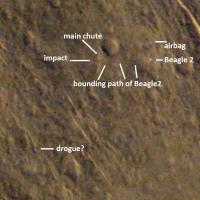
I have yet to collapse them all into one image, but that is a chore for another night. The bright object to the north is most likely an airbag? The three gas bags protecting Beagle were supposed to be 'ejected' away from Beagle after landing Where are the other two? (covered in dirty dust and looking like surrounding ground? ) I am a little disappointed by the greenish tinges, but my program did the best it could (it's optimized for grayscales) The 'parachute' is in this image at the southwest. The backshell may the one of the dark objects to the west or south of the 'parachute'? EDIT: the backshell was ejected with the dogue chute .. which remains to be imaged?? These objects are really small. Congratulations to the Beagle Team for what looks like a good EDL and the MRO team for a great observatory in orbit around another planet (wow) .... more later ...
-------------------- CLA CLL
|
|
|
|
|
|
|
Jan 18 2015, 04:23 AM
Post
#42
|
||
|
Member Group: Members Posts: 808 Joined: 10-October 06 From: Maynard Mass USA Member No.: 1241 |
Beagle 2 came down on two parachutes the drogue that did the initial slowdown and ejected the backshell and then the main chute that brought it down to the ground and then was cut away on landing. So the main chute should be 'near' the lander, and the drogue further away. After looking at this image I would like to postulate the position of the 'main' chute and the bounding, rolling path of Beagle 2. (of course ... as my wife reminds me almost weekly... I could be wrong...)

-------------------- CLA CLL
|
|
|
|
|
|
|
Jan 18 2015, 05:11 AM
Post
#43
|
|
 Member Group: Members Posts: 754 Joined: 9-February 07 Member No.: 1700 |
Communication was lost after Beagle separated, but it may have actually landed softly enough and deployed solar panels. Could that mean it took in some data? If it landed intact, and some day we got a robot or astronaut to recover the vessel, would it be possible to retrieve any such data from its hard drive or flash drive? Granted, the harsh conditions would degrade anything sitting around for years and years but it's interesting to consider...
In general once our robotic craft lose energy and conk out, could their hard drives or flash drives theoretically be retrieved like black boxes on earthly aircraft? |
|
|
|
|
Jan 18 2015, 04:10 PM
Post
#44
|
|
|
Solar System Cartographer Group: Members Posts: 10226 Joined: 5-April 05 From: Canada Member No.: 227 |
"I'm not sure I understand what you're saying. Since there was no communication with the orbiter after release, the nav ellipse must have been predicted at that time. I would think that the target ellipse was the plan before encountering Mars, maybe even before launch.
-Tim." You're right about both ellipses. The pre-landing target was the pre-launch target, as you say. But the final navigation solution leads to a much smaller ellipse when all the numbers are in (post-landing), giving you a smaller area to search with orbital cameras. The final version of the target ellipse was 174 by 106 km (Bridges et al. paper in 2003). The navigation solution was an ellipse 57 by 7.6 km across (Sims, 2004, Beagle 2 Mission Report). The University of Leicester and the UK Space Agency both said this correctly. The BBC report is the one which says it was 5 km from the middle of the target ellipse - that's what I'm suggesting is misleading. Phil -------------------- ... because the Solar System ain't gonna map itself.
Also to be found posting similar content on https://mastodon.social/@PhilStooke Maps for download (free PDF: https://upload.wikimedia.org/wikipedia/comm...Cartography.pdf NOTE: everything created by me which I post on UMSF is considered to be in the public domain (NOT CC, public domain) |
|
|
|
|
Jan 19 2015, 02:40 PM
Post
#45
|
|
|
Member Group: Members Posts: 107 Joined: 1-August 14 Member No.: 7227 |
QUOTE (robspace54b @ Jan 16 2015, 03:11 PM) Here are a couple more Beagle2 photos showing the UHF antenna (yellow square) I read in an article that one "lesson learnt", already being adopted in upcoming Exomars mission, is the lander to continuously send data to orbiter during EDL. I think an additional lesson learnt is "don't cover the only one antenna by 4 plates", as one single failure out of 4 will compromise whole mission. Maybe a "contingency omnidirectional low power autonomous-battery external antenna" will become a standard in all next landers? QUOTE (Phil Stooke @ Jan 17 2015, 10:09 PM) Looking at the details. The landing site is about 5 km from the middle of the post-landing tracking ellipse, but about 30 km from the middle of the pre-landing target ellipse. Some reports confuse the two. It was not 5 km off target. I am curious: why did it take so long to find Beagle2 if it is within the planned landing ellipse? Is this the first ever shot HIRISE image of the area? QUOTE (PDP8E @ Jan 18 2015, 03:58 AM) The three gas bags protecting Beagle were supposed to be 'ejected' away from Beagle after landing This is weird, I was not aware of it. Looking for and EDL animation I found this also weird video; guess made by who? http://youtu.be/YjNyweyGwHQ Airbags do not even appear in this video... Beagle is quite crashing rather than landing! A better, official video from internet archive: http://web.archive.org/web/20071006015240/...t_a_640x368.mov From: http://www.beagle2.com/resources/video-album.htm lo-res animation attached ( 160x192).
Attached File(s)
|
|
|
|
|

|
Lo-Fi Version | Time is now: 23rd September 2024 - 01:59 PM |
|
RULES AND GUIDELINES Please read the Forum Rules and Guidelines before posting. IMAGE COPYRIGHT |
OPINIONS AND MODERATION Opinions expressed on UnmannedSpaceflight.com are those of the individual posters and do not necessarily reflect the opinions of UnmannedSpaceflight.com or The Planetary Society. The all-volunteer UnmannedSpaceflight.com moderation team is wholly independent of The Planetary Society. The Planetary Society has no influence over decisions made by the UnmannedSpaceflight.com moderators. |
SUPPORT THE FORUM Unmannedspaceflight.com is funded by the Planetary Society. Please consider supporting our work and many other projects by donating to the Society or becoming a member. |
|