Yutu-2 route map |

  |
Yutu-2 route map |
 Jun 26 2019, 07:19 PM Jun 26 2019, 07:19 PM
Post
#31
|
||||
|
Solar System Cartographer  Group: Members Posts: 10146 Joined: 5-April 05 From: Canada Member No.: 227 |
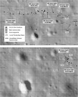
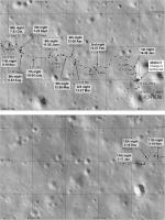
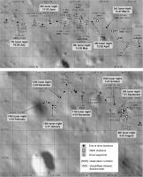
Pictures from lunar day 6, released at the start of lunar day 7, let me revise the route map. I don't really know that those images cover all the day 6 tracks or that I have joined them correctly, but this is what i have at the moment.
3 maps this time. The first is the updated version of the previous map. The other two are more detailed maps adding labels from a recent Chinese map noted in the other thread. I have changed symbols and added a legend to match previous work on Chang'e 3's route map. Phil
-------------------- ... because the Solar System ain't gonna map itself.
Also to be found posting similar content on https://mastodon.social/@PhilStooke NOTE: everything created by me which I post on UMSF is considered to be in the public domain (NOT CC, public domain) |
|||
 |
 
|
|||
|
Jul 9 2019, 08:30 PM
Post
#32
|
|||
|
Solar System Cartographer Group: Members Posts: 10146 Joined: 5-April 05 From: Canada Member No.: 227 |
This is a preliminary update based on the reprojected image shown in the other thread. I think that image is from the mid-day siesta, based on illumination, and there is no indication how far Yutu 2 has moved since then. My scaling of the new drive is only approximate. So basically it's all guesswork so far. But I am suggesting a drive on the order of 40 m on the 7th day.
Phil
-------------------- ... because the Solar System ain't gonna map itself.
Also to be found posting similar content on https://mastodon.social/@PhilStooke NOTE: everything created by me which I post on UMSF is considered to be in the public domain (NOT CC, public domain) |
||
|
|
|
||
|
Aug 7 2019, 05:30 PM
Post
#33
|
||
|
Solar System Cartographer Group: Members Posts: 10146 Joined: 5-April 05 From: Canada Member No.: 227 |
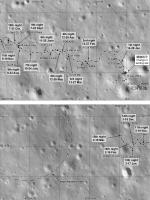
Andrew Jones tweeted a total distance of 271 m after day 8 which lets me estimate a new position. Since the last map I have pulled my estimated position for the end of day 7 back a bit. This map extends the base to the west to show a sharp-rimmed crater ahead. Will it be a future target? I am trying to decide if this crater is shown as a bright band across one of the newly-released images (see discussion in the main thread).
Phil
-------------------- ... because the Solar System ain't gonna map itself.
Also to be found posting similar content on https://mastodon.social/@PhilStooke NOTE: everything created by me which I post on UMSF is considered to be in the public domain (NOT CC, public domain) |
|
|
|
|
|
|
Sep 18 2019, 08:59 PM
Post
#34
|
||
|
Solar System Cartographer Group: Members Posts: 10146 Joined: 5-April 05 From: Canada Member No.: 227 |
Took a while to get this together from the latest data. As always, changes may be needed later!
Phil
-------------------- ... because the Solar System ain't gonna map itself.
Also to be found posting similar content on https://mastodon.social/@PhilStooke NOTE: everything created by me which I post on UMSF is considered to be in the public domain (NOT CC, public domain) |
|
|
|
|
|
|
Oct 2 2019, 10:06 PM
Post
#35
|
|||
|
Solar System Cartographer Group: Members Posts: 10146 Joined: 5-April 05 From: Canada Member No.: 227 |
A new paper in Earth and Planetary Science Letters ( Gou et al., 2019. Lunar deep materials observed by Chang'e-4 rover. Earth and Planetary Science Letters, v. 528, 115829. https://doi.org/10.1016/j.epsl.2019.115829 ) provides more details of VNIS operations. I have used it to update the more detailed version of my map.
Phil
-------------------- ... because the Solar System ain't gonna map itself.
Also to be found posting similar content on https://mastodon.social/@PhilStooke NOTE: everything created by me which I post on UMSF is considered to be in the public domain (NOT CC, public domain) |
||
|
|
|
||
|
Nov 5 2019, 09:29 PM
Post
#36
|
||
|
Solar System Cartographer Group: Members Posts: 10146 Joined: 5-April 05 From: Canada Member No.: 227 |
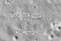
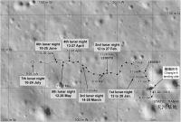
This is my estimate of the location after the 11th day of operation. The point is chosen to give a distance from the lander of 218 m, a path in day 11 which avoids craters, and to reflect my hope that the prominent crater SW of the current position will be investigated. Needless to say, I may have to revise this when I get new images of the tracks.
My lunar night dates are a bit unreliable, but I have not found time to check the actual sunset-sunrise dates for each month. I will try to sort that out soon. I think my dates are mixing up UTC dates and dates in China, and are further messed up by my efforts to adjust them. Also this is a composite of two maps joined together, and the join is not perfect. Mars has been interfering with the Moon in my life recently. Phil
Attached thumbnail(s)
-------------------- ... because the Solar System ain't gonna map itself.
Also to be found posting similar content on https://mastodon.social/@PhilStooke NOTE: everything created by me which I post on UMSF is considered to be in the public domain (NOT CC, public domain) |
|
|
|
|
|
|
Dec 13 2019, 02:11 AM
Post
#37
|
||
|
Solar System Cartographer Group: Members Posts: 10146 Joined: 5-April 05 From: Canada Member No.: 227 |
A new map update using the newest Day 12 images.
Phil
-------------------- ... because the Solar System ain't gonna map itself.
Also to be found posting similar content on https://mastodon.social/@PhilStooke NOTE: everything created by me which I post on UMSF is considered to be in the public domain (NOT CC, public domain) |
|
|
|
|
|
|
Jan 4 2020, 03:43 AM
Post
#38
|
||
|
Solar System Cartographer Group: Members Posts: 10146 Joined: 5-April 05 From: Canada Member No.: 227 |
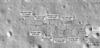
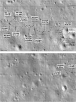
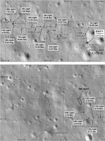
OK, new data! From maps and a video of the traverse tweeted by Andrew Jones I have updated the route map to the end of lunar day 13.
This base image (an LRO orthophoto) has been adjusted to match the Chinese maps. My grid is labelled with zero at the lander, which I prefer to their approach. The last few days are based on images of tracks including frames from the video. The tracks in the video show the actual traverse pattern but the landscape is schematic, not the real pattern of craters. Phil
EDIT: Map replaced on 4 Jan 2020 - correcting two errors. -------------------- ... because the Solar System ain't gonna map itself.
Also to be found posting similar content on https://mastodon.social/@PhilStooke NOTE: everything created by me which I post on UMSF is considered to be in the public domain (NOT CC, public domain) |
|
|
|
|
|
|
Jan 16 2020, 08:07 PM
Post
#39
|
||
|
Solar System Cartographer Group: Members Posts: 10146 Joined: 5-April 05 From: Canada Member No.: 227 |
This is my current route map, updated using the new panoramas from the PDS release and other recent images. Thanks to Doug for all his work on panoramas.
Yutu 2 will soon wake up for lunar day 14. The Chinese PDS node just released the lunar penetrating radar data for the first two lunar days. Phil -------------------- ... because the Solar System ain't gonna map itself.
Also to be found posting similar content on https://mastodon.social/@PhilStooke NOTE: everything created by me which I post on UMSF is considered to be in the public domain (NOT CC, public domain) |
|
|
|
|
|
|
Feb 7 2020, 08:52 PM
Post
#40
|
||
|
Solar System Cartographer Group: Members Posts: 10146 Joined: 5-April 05 From: Canada Member No.: 227 |
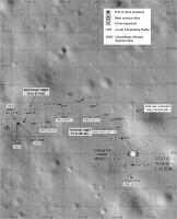
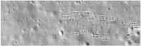
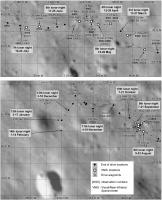
I am incorporating those observation numbers (or whatever we should call them) into the map, and correcting dates as I get more information. This is the enlarged version of the map, and I will repost the first panel of this map (the landing site) later when i have done more to it. Oh yes - and I am adding parts of reprojected panoramas where I have them - lots more to add.
I don't have any information on the 14th night location so it is only roughly indicated. Phil
-------------------- ... because the Solar System ain't gonna map itself.
Also to be found posting similar content on https://mastodon.social/@PhilStooke NOTE: everything created by me which I post on UMSF is considered to be in the public domain (NOT CC, public domain) |
|
|
|
|
|
|
Feb 8 2020, 06:21 AM
Post
#41
|
||
|
Solar System Cartographer Group: Members Posts: 10146 Joined: 5-April 05 From: Canada Member No.: 227 |
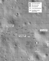
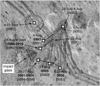
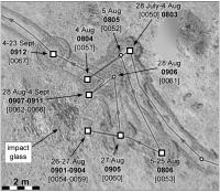
Here's a special map of the area around the impact glass crater. I'm not certain of every detail but this fits everything I know so far.
Phil
-------------------- ... because the Solar System ain't gonna map itself.
Also to be found posting similar content on https://mastodon.social/@PhilStooke NOTE: everything created by me which I post on UMSF is considered to be in the public domain (NOT CC, public domain) |
|
|
|
|
|
|
Feb 15 2020, 09:42 PM
Post
#42
|
|||
|
Solar System Cartographer Group: Members Posts: 10146 Joined: 5-April 05 From: Canada Member No.: 227 |
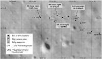
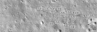
Here is an updated version of the map. Still no information on the day 14 activities but I have corrected dates and updated the 4th night location.
Phil
EDIT: Stop the presses!!! Just learned more via a tweet from Andrew Jones with a link to a drive diary and new images. Now I can update day 14 properly. Phil
-------------------- ... because the Solar System ain't gonna map itself.
Also to be found posting similar content on https://mastodon.social/@PhilStooke NOTE: everything created by me which I post on UMSF is considered to be in the public domain (NOT CC, public domain) |
||
|
|
|
||
|
Mar 5 2020, 06:04 PM
Post
#43
|
||
|
Solar System Cartographer Group: Members Posts: 10146 Joined: 5-April 05 From: Canada Member No.: 227 |
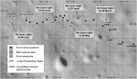
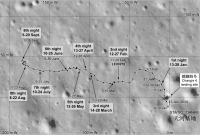
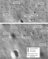
Here's a map update to day 15, which just ended. The details of the last few days have been adjusted to match new maps which Andrew Jones tweeted recently (I will put a link to the source in our main thread). I am having a bit of trouble reconciling that map with published drive distances, especially for day 15 which should show 33 m driving. The grid on this map is 50 m by 50 m. It is possible that the newly released map doesn't go right to the end of day 15. The large degraded crater now shown on the map is described in the Chinese source as an obstacle they have to avoid so they are going to pass it on the northeast side as they begin a long trek to the northwest. They have turned away from the prominent crater to the south of the 13th night position which was an earlier target.
Phil
-------------------- ... because the Solar System ain't gonna map itself.
Also to be found posting similar content on https://mastodon.social/@PhilStooke NOTE: everything created by me which I post on UMSF is considered to be in the public domain (NOT CC, public domain) |
|
|
|
|
|
|
Apr 8 2020, 09:37 PM
Post
#44
|
||
|
Solar System Cartographer Group: Members Posts: 10146 Joined: 5-April 05 From: Canada Member No.: 227 |
A very tentative update to the 16th lunar night, which we are in as I post this. It's based on nothing but drive distances, and since I am dubious about my 15th night location (see above) I show a large uncertainty in the location for the 16th night. I hope to know more soon.
Phil
-------------------- ... because the Solar System ain't gonna map itself.
Also to be found posting similar content on https://mastodon.social/@PhilStooke NOTE: everything created by me which I post on UMSF is considered to be in the public domain (NOT CC, public domain) |
|
|
|
|
|
|
Apr 8 2020, 11:42 PM
Post
#45
|
||
|
Solar System Cartographer Group: Members Posts: 10146 Joined: 5-April 05 From: Canada Member No.: 227 |
This is an updated version of the map shown a few posts ago, the impact glass (AKA 'gel') crater. The base image is more accurately projected based on a map in a new paper by Ding et al. in Geophysical Research Letters. Some changes to site designations as well. The paper suggests that this and other small blocky craters seen nearby are secondaries from Zhinyu crater, 40 km to the west.
Phil
-------------------- ... because the Solar System ain't gonna map itself.
Also to be found posting similar content on https://mastodon.social/@PhilStooke NOTE: everything created by me which I post on UMSF is considered to be in the public domain (NOT CC, public domain) |
|
|
|
|
|
|

|
Lo-Fi Version | Time is now: 18th April 2024 - 11:58 PM |
|
RULES AND GUIDELINES Please read the Forum Rules and Guidelines before posting. IMAGE COPYRIGHT |
OPINIONS AND MODERATION Opinions expressed on UnmannedSpaceflight.com are those of the individual posters and do not necessarily reflect the opinions of UnmannedSpaceflight.com or The Planetary Society. The all-volunteer UnmannedSpaceflight.com moderation team is wholly independent of The Planetary Society. The Planetary Society has no influence over decisions made by the UnmannedSpaceflight.com moderators. |
SUPPORT THE FORUM Unmannedspaceflight.com is funded by the Planetary Society. Please consider supporting our work and many other projects by donating to the Society or becoming a member. |
|