Opportunity Route Map |

  |
Opportunity Route Map |
 Aug 4 2006, 08:27 PM Aug 4 2006, 08:27 PM
Post
#1741
|
|
|
Senior Member  Group: Members Posts: 2998 Joined: 30-October 04 Member No.: 105 |
I'd go for the naming of names on the Route Map, as long as isn't too cluttered. But as a convention, we ought to put "informal" names in quotation marks and formal names without quotes, ie "Corner Crater" and Beagle Crater.
--Bill -------------------- |
 |
 
|
|
Aug 4 2006, 08:34 PM
Post
#1742
|
||
|
Solar System Cartographer Group: Members Posts: 10152 Joined: 5-April 05 From: Canada Member No.: 227 |
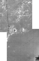
My map - which has been posted here before in a reduced format - is in a different style. I will not update the other map, I'll post the latest version of mine as I update it.
(edit) - here is the current version of my Opportunity map. I am mapping the route in 500 m square sections, each section will be a separate illustration in a future project. Here I combine the two most recent of them (sections 14 and 15). The grid is labelled in meters from the landing site. Phil
-------------------- ... because the Solar System ain't gonna map itself.
Also to be found posting similar content on https://mastodon.social/@PhilStooke Maps for download (free PD: https://upload.wikimedia.org/wikipedia/comm...Cartography.pdf NOTE: everything created by me which I post on UMSF is considered to be in the public domain (NOT CC, public domain) |
|
|
|
|
|
|
Aug 6 2006, 03:29 PM
Post
#1743
|
|
 Member Group: Members Posts: 160 Joined: 4-July 05 From: Huntington Beach, CA, USA Member No.: 429 |
QUOTE (Phil Stooke @ Aug 4 2006, 04:34 PM)  My map - which has been posted here before in a reduced format - is in a different style. I will not update the other map, I'll post the latest version of mine as I update it. Beautiful! Thank you, Phil! Looking forward to the updates. And by the way, can we have Spirit's map in this format, please? You won't need to update it often, in the next few months anyway 
|
|
|
|
|
Aug 6 2006, 04:40 PM
Post
#1744
|
|
|
Solar System Cartographer Group: Members Posts: 10152 Joined: 5-April 05 From: Canada Member No.: 227 |
OK, it's over in the Spirit area.
Phil -------------------- ... because the Solar System ain't gonna map itself.
Also to be found posting similar content on https://mastodon.social/@PhilStooke Maps for download (free PD: https://upload.wikimedia.org/wikipedia/comm...Cartography.pdf NOTE: everything created by me which I post on UMSF is considered to be in the public domain (NOT CC, public domain) |
|
|
|
|
Aug 8 2006, 01:21 PM
Post
#1745
|
|
 Member Group: Members Posts: 656 Joined: 20-April 05 From: League City, Texas Member No.: 285 |
Just FYI, especially for the benefit of the mappers and navigators, I've just posted a major new release of AlgorimancerPG to the "Tech, General and Imagery" section. The new version has the option to incorporate rover and masthead orientation so as to output coordinates in the local topocentric frame, plus has the capability of wide baseline photogrammetry (using images from separate rover locations) to greatly extend the range and accuracy of the results.
|
|
|
|
|
Aug 8 2006, 11:16 PM
Post
#1746
|
|
|
Member Group: Members Posts: 109 Joined: 9-April 04 Member No.: 66 |
Wasn't today a drve sol?
|
|
|
|
|
Aug 9 2006, 01:13 AM
Post
#1747
|
|
|
Senior Member Group: Members Posts: 1636 Joined: 9-May 05 From: Lima, Peru Member No.: 385 |
QUOTE (gregp1962 @ Aug 8 2006, 06:16 PM) Wasn't today a drve sol? Yes, today at this time ( past 14:00 pm Mars time) Oppy is being tranversing. The most probable driving direction is around 90 degree azimuth (toward to north rim of Victoria Crater). Rodolfo |
|
|
|
|
Aug 9 2006, 07:07 AM
Post
#1748
|
|
|
Founder Group: Chairman Posts: 14432 Joined: 8-February 04 Member No.: 1 |
QUOTE (RNeuhaus @ Aug 9 2006, 02:13 AM) The most probable driving direction is around 90 degree azimuth (toward to north rim of Victoria Crater). There is no suggestion that they are driving to Victoria yet - none at all. There is work to be done at Beagle first. Doug |
|
|
|
|
Aug 9 2006, 12:40 PM
Post
#1749
|
|
 Member Group: Members Posts: 578 Joined: 5-November 04 From: Denmark Member No.: 107 |
http://www.newscientistspace.com/article/d...good-shape.html
QUOTE On 14 August, Opportunity will start driving towards Victoria crater, which is 800 m across and perhaps 40 m deep. This journey is expected to take about a month.
-------------------- "I want to make as many people as possible feel like they are part of this adventure. We are going to give everybody a sense of what exploring the surface of another world is really like"
- Steven Squyres |
|
|
|
|
Aug 9 2006, 12:51 PM
Post
#1750
|
|
|
Founder Group: Chairman Posts: 14432 Joined: 8-February 04 Member No.: 1 |
5 days - sounds like one thorough IDD campaign to me.
Doug |
|
|
|
|
Aug 12 2006, 12:45 AM
Post
#1751
|
||
 The Insider Group: Members Posts: 669 Joined: 3-May 04 Member No.: 73 |
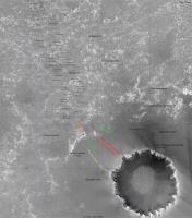
Here's a nice map (a bit old though). Not sure if you guys have seen this thing or not...
Attached thumbnail(s)
|
|
|
|
|
|
|
Aug 12 2006, 04:05 AM
Post
#1752
|
|
 Senior Member Group: Members Posts: 2228 Joined: 1-December 04 From: Marble Falls, Texas, USA Member No.: 116 |
No, we haven't! ...and it's a keeper.
Very intriguing on a number of levels. Many thanks, Pando.edit: I forgot to say, aside from the fascinating future route map, I noticed the original plan was to take an early diagonal toward Beagle as many here were guessing before we saw the dunes from the rover's eyes. But more fascinating to me are the arrows pointing to this new Halfpipe formation right around the Hell of a View location. I'm going back to see if I can figure out what that is all about. Lastly, if you can put your fingers on any other adjoining pieces of that map, some of us would be very appreciative. 
-------------------- ...Tom
I'm not a Space Fan, I'm a Space Exploration Enthusiast. |
|
|
|
|
Aug 12 2006, 04:24 AM
Post
#1753
|
|
 Senior Member Group: Admin Posts: 4763 Joined: 15-March 05 From: Glendale, AZ Member No.: 197 |
QUOTE (Pando @ Aug 11 2006, 04:45 PM) Here's a nice map (a bit old though). Not sure if you guys have seen this thing or not... Have we been digging in the trash bin out behind JPL? -------------------- If Occam had heard my theory, things would be very different now.
|
|
|
|
|
Aug 12 2006, 05:15 AM
Post
#1754
|
|
|
Member Group: Members Posts: 320 Joined: 19-June 04 Member No.: 85 |
QUOTE (CosmicRocker @ Aug 12 2006, 04:05 AM) But more fascinating to me are the arrows pointing to this new Halfpipe formation right around the Hell of a View location. Absolutely! This suggests that we encountered a new stratigraphic horizon at Payson, where the term first appeared. But are we above or below the Burns Formation? Any other crumbs lying around JPL's trashbin, Pando?? 
-------------------- |
|
|
|
|
Aug 12 2006, 06:59 AM
Post
#1755
|
|
|
Senior Member Group: Members Posts: 2228 Joined: 1-December 04 From: Marble Falls, Texas, USA Member No.: 116 |
Good to see you on the hunt, aldo12xu.
This new formation name made me dig back into previous panoramas. Thank god for MMB.Here are the clues that I had to start with. * Pando's map * According to my notes from the LPSC this spring, Grotzinger and others mentioned something called the "Mogollon Contact," which was the highest contact mentioned so far, but they said very little else about it. It is supposed to be above Burns and it's contacts. * Back when they were at Mogollon they used the term "halfpipe" to describe the low road they took below the outcrop ledge. * So, we have a contact (possibly between two geological formations) named the Mogollon contact, and the named geomorphic feature called halfpipe that they drove through in the vicinity. * Phil's very nicely annotated map. * later, (around Hell of a View) they are pointing to other ledges and the Halfpipe formation on Pando's map. I went back to Mogollon and and later sites to look around. In all of them there is a ledge nearby, and in some of them, there are also dark cobbles about. It's a pretty convincing geomorphic layer. It is late, so I am passing the ball to the nearest person... -------------------- ...Tom
I'm not a Space Fan, I'm a Space Exploration Enthusiast. |
|
|
|
|

|
Lo-Fi Version | Time is now: 26th April 2024 - 08:24 PM |
|
RULES AND GUIDELINES Please read the Forum Rules and Guidelines before posting. IMAGE COPYRIGHT |
OPINIONS AND MODERATION Opinions expressed on UnmannedSpaceflight.com are those of the individual posters and do not necessarily reflect the opinions of UnmannedSpaceflight.com or The Planetary Society. The all-volunteer UnmannedSpaceflight.com moderation team is wholly independent of The Planetary Society. The Planetary Society has no influence over decisions made by the UnmannedSpaceflight.com moderators. |
SUPPORT THE FORUM Unmannedspaceflight.com is funded by the Planetary Society. Please consider supporting our work and many other projects by donating to the Society or becoming a member. |
|