Reprocessing Historical Images, Looking for REALLY big challenges? |

  |
Reprocessing Historical Images, Looking for REALLY big challenges? |
 Jan 19 2006, 06:40 PM Jan 19 2006, 06:40 PM
Post
#376
|
|
|
Solar System Cartographer  Group: Members Posts: 10151 Joined: 5-April 05 From: Canada Member No.: 227 |
No, tty, NASA does understand it. They archive everything through the National Space Science Data Center B in Greenbelt, Maryland. The problem is that the archive format for older images was film, not digital data. The intelligence images you mentioned are probably on film for the earlier years as well. (Many were on film from the start, returned in reentry capsules).
Phil -------------------- ... because the Solar System ain't gonna map itself.
Also to be found posting similar content on https://mastodon.social/@PhilStooke Maps for download (free PD: https://upload.wikimedia.org/wikipedia/comm...Cartography.pdf NOTE: everything created by me which I post on UMSF is considered to be in the public domain (NOT CC, public domain) |
 |
 
|
|
Jan 19 2006, 09:29 PM
Post
#377
|
|
 Interplanetary Dumpster Diver Group: Admin Posts: 4404 Joined: 17-February 04 From: Powell, TN Member No.: 33 |
QUOTE (Phil Stooke @ Jan 19 2006, 06:40 PM) No, tty, NASA does understand it. They archive everything through the National Space Science Data Center B in Greenbelt, Maryland. The problem is that the archive format for older images was film, not digital data. The intelligence images you mentioned are probably on film for the earlier years as well. (Many were on film from the start, returned in reentry capsules). Phil  It is important to remember that in the days of Mariner 4 (which carried the first fully digital imaging camera ever), digital data was considered something that would have to be dealt with until film could be returned, so when it was received, it was coverted to print images. In fact, the Mariner 6/7 images were handled this way, and were salvaged in the 1990s from old tapes that, according to some accounts, crumbled as they were being read. -------------------- |
|
|
|
|
Jan 22 2006, 09:51 PM
Post
#378
|
|||
|
Solar System Cartographer Group: Members Posts: 10151 Joined: 5-April 05 From: Canada Member No.: 227 |
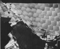
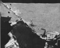
Time to unveil my current project. I have been cleaning up the Surveyor panoramas. The only one left to do is Surveyor 6. This is the first section of it... about 10% of the whole thing.
First, here is the 'raw' data scanned from prints of photos of the mosaics, originally made at JPL (NOT the set made at USGS Flagstaff) and scanned by me during visits to the Lunar and Planetary Lab, University of Arizona, and USGS Flagstaff.
And here is a version with the frame-to-frame tonal variations corrected, and reseaux and other defects removed. I don't do much to areas on the spacecraft itself because the parallax renders it unfixable. THe scene is very bland because the sun is high, but there are rocks and a few craters, faintly seen. The rest of the pan will be more interesting, especially the area affected by the 'hop'. The horizon seen here is northwest of the spacecraft. My original is more than twice this size. Phil
-------------------- ... because the Solar System ain't gonna map itself.
Also to be found posting similar content on https://mastodon.social/@PhilStooke Maps for download (free PD: https://upload.wikimedia.org/wikipedia/comm...Cartography.pdf NOTE: everything created by me which I post on UMSF is considered to be in the public domain (NOT CC, public domain) |
||
|
|
|
||
|
Jan 22 2006, 10:24 PM
Post
#379
|
|
 Senior Member Group: Members Posts: 2492 Joined: 15-January 05 From: center Italy Member No.: 150 |
Wow, Phil. Which is original resolution of single images?
-------------------- I always think before posting! - Marco -
|
|
|
|
|
Jan 23 2006, 02:03 PM
Post
#380
|
|
|
Solar System Cartographer Group: Members Posts: 10151 Joined: 5-April 05 From: Canada Member No.: 227 |
Dilo, my full panorama is 11000 pixels long. This is still much smaller than a true full resolution pan would be if made from the original frames. Each individual frame is 600 pixels across.
Phil -------------------- ... because the Solar System ain't gonna map itself.
Also to be found posting similar content on https://mastodon.social/@PhilStooke Maps for download (free PD: https://upload.wikimedia.org/wikipedia/comm...Cartography.pdf NOTE: everything created by me which I post on UMSF is considered to be in the public domain (NOT CC, public domain) |
|
|
|
|
Jan 23 2006, 02:20 PM
Post
#381
|
|
 Member Group: Members Posts: 753 Joined: 23-October 04 From: Greensboro, NC USA Member No.: 103 |
Holy moley, Phil! This is obviously a labor of love. Amazing work!
-------------------- Jonathan Ward
Manning the LCC at http://www.apollolaunchcontrol.com |
|
|
|
|
Jan 23 2006, 04:26 PM
Post
#382
|
|
 Member Group: Members Posts: 345 Joined: 2-May 05 Member No.: 372 |
Great work Phil! Considering how much work you're putting into this, hopefully you have redundant backups of redundant backups!
|
|
|
|
|
Jan 23 2006, 05:08 PM
Post
#383
|
|
 Member Group: Members Posts: 106 Joined: 26-September 05 Member No.: 508 |
Hi Phil,
There are a lots of film data sets available from NSSDC, including Surveyor data. Have you ever seen them or do you have any idea about their quality? |
|
|
|
|
Jan 23 2006, 07:01 PM
Post
#384
|
|
|
Solar System Cartographer Group: Members Posts: 10151 Joined: 5-April 05 From: Canada Member No.: 227 |
I have not looked at the NSSDC stuff. At LPI in Houston I have seen boxes of Surveyor negatives - not very carefully stored, but of course they are not deep-archived at that location. It would be a nightmare to try to use them because of the state of indexing.
In principle, though, anybody has access to LPI data, especially these days with portable scanners and so on - I had to beg an account and access to their system. But the staff are unbelievably helpful and accomodating. I must say, through, I was met with initial disbelief that anybody would want to attempt this. One person said - Oh, you don't want to work with Surveyor - Apollo would be much easier.' Yes, that's true, but it doesn't help if you want to show Surveyor pans in all their gory glory. The USGS book 'Atlas of Surveyor 5 Television Data' indexes that mission quite well. (incidentally, people might like looking at the range of Surveyor 5 pan sections in that book - some could be assembled into very nice pan images without all the garbage I am wading through right now, but unfortunately books like this were not made for the other missions). There is a name for this sort of compulsive behaviour, but as it's not very polite I prefer to use it only for other people. Phil -------------------- ... because the Solar System ain't gonna map itself.
Also to be found posting similar content on https://mastodon.social/@PhilStooke Maps for download (free PD: https://upload.wikimedia.org/wikipedia/comm...Cartography.pdf NOTE: everything created by me which I post on UMSF is considered to be in the public domain (NOT CC, public domain) |
|
|
|
|
Jan 23 2006, 08:12 PM
Post
#385
|
|
|
Founder Group: Chairman Posts: 14432 Joined: 8-February 04 Member No.: 1 |
QUOTE (Phil Stooke @ Jan 23 2006, 07:01 PM) There is a name for this sort of compulsive behaviour, but as it's not very polite I prefer to use it only for other people. It's called 'CFM' Complete Madness  Doug |
|
|
|
|
Jan 23 2006, 11:23 PM
Post
#386
|
|
 Senior Member Group: Members Posts: 2488 Joined: 17-April 05 From: Glasgow, Scotland, UK Member No.: 239 |
Phil:
Please stay off the medication long enough to do some more of these stunning panoramas! Bob Shaw -------------------- Remember: Time Flies like the wind - but Fruit Flies like bananas!
|
|
|
|
|
Jan 24 2006, 01:24 AM
Post
#387
|
|
|
Solar System Cartographer Group: Members Posts: 10151 Joined: 5-April 05 From: Canada Member No.: 227 |
Bob - you spoilsport! I like my medication. In fact I think I'll have a glass now.
Phil -------------------- ... because the Solar System ain't gonna map itself.
Also to be found posting similar content on https://mastodon.social/@PhilStooke Maps for download (free PD: https://upload.wikimedia.org/wikipedia/comm...Cartography.pdf NOTE: everything created by me which I post on UMSF is considered to be in the public domain (NOT CC, public domain) |
|
|
|
|
Jan 24 2006, 07:30 PM
Post
#388
|
|
|
Junior Member Group: Members Posts: 37 Joined: 20-November 05 Member No.: 561 |
Phil, some months back in this thread (long thread!) you mentioned you were saving some more detailed Moon mosaics for your "book." What book, and when will it be available?
Oh, and speaking of books... For Mariner 4 Volume 2, it's not looking good. The Lunar and Planetary Institute now lists only Volume 1 on their online catalog. Ditto for the Smithsonian Archives. Ames won't even show you an online search unless you're a genuine scientist--darn. I've only done online searching, but I'm getting the feeling that JPL itself is the only one with the last copy in the world. Um, are there any spies at JPL who could sneak into the Secret Archives and illegally xerox? I could probably pay for the cost of a few pages at a time.... Oh well. At least "TR-32-884" made a great password at work, where you have to come up with a new one every few weeks, never use an old one again, and has to have numbers and letters both. John D. |
|
|
|
|
Jan 24 2006, 08:20 PM
Post
#389
|
|
|
Solar System Cartographer Group: Members Posts: 10151 Joined: 5-April 05 From: Canada Member No.: 227 |
The International Atlas of Lunar Exploration, Cambridge, October 2007 (50th anniversary of Sputnik).
The full res Surveyor pans will eventually be on a USGS website, if current plans hold. Phil -------------------- ... because the Solar System ain't gonna map itself.
Also to be found posting similar content on https://mastodon.social/@PhilStooke Maps for download (free PD: https://upload.wikimedia.org/wikipedia/comm...Cartography.pdf NOTE: everything created by me which I post on UMSF is considered to be in the public domain (NOT CC, public domain) |
|
|
|
|
Jan 24 2006, 08:23 PM
Post
#390
|
|
|
Senior Member Group: Members Posts: 2488 Joined: 17-April 05 From: Glasgow, Scotland, UK Member No.: 239 |
QUOTE (Phil Stooke @ Jan 24 2006, 09:20 PM) The International Atlas of Lunar Exploration, Cambridge, October 2007 (50th anniversary of Sputnik). The full res Surveyor pans will eventually be on a USGS website, if current plans hold. Phil Phil: When's the book launch *party*, and are we all invited? Bring your own naptha? Bob Shaw -------------------- Remember: Time Flies like the wind - but Fruit Flies like bananas!
|
|
|
|
|

|
Lo-Fi Version | Time is now: 26th April 2024 - 09:30 AM |
|
RULES AND GUIDELINES Please read the Forum Rules and Guidelines before posting. IMAGE COPYRIGHT |
OPINIONS AND MODERATION Opinions expressed on UnmannedSpaceflight.com are those of the individual posters and do not necessarily reflect the opinions of UnmannedSpaceflight.com or The Planetary Society. The all-volunteer UnmannedSpaceflight.com moderation team is wholly independent of The Planetary Society. The Planetary Society has no influence over decisions made by the UnmannedSpaceflight.com moderators. |
SUPPORT THE FORUM Unmannedspaceflight.com is funded by the Planetary Society. Please consider supporting our work and many other projects by donating to the Society or becoming a member. |
|