MSL at Rocknest, First scoop samples - sols 57-101 |

  |
MSL at Rocknest, First scoop samples - sols 57-101 |
 Oct 6 2012, 10:56 PM Oct 6 2012, 10:56 PM
Post
#46
|
|
 Senior Member  Group: Members Posts: 1619 Joined: 12-February 06 From: Bergerac - FR Member No.: 678 |
It's a little late for this but :
Sol 57 mosaics : 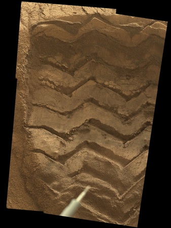 The link is going to my new galery of Curiosity image, totally remade, with a timeline of the events, classified by sols, and each picture is horodated, with a minute precision. I hope you will like it  . This give the feeling of the time, I think. . This give the feeling of the time, I think.
-------------------- |
 |
 
|
|
Oct 7 2012, 12:28 AM
Post
#47
|
|
 Member Group: Members Posts: 276 Joined: 11-December 07 From: Dar es Salaam, Tanzania Member No.: 3978 |
I like the timeline on your web Ant! Definitely worth it!
-------------------- |
|
|
|
|
Oct 7 2012, 12:29 AM
Post
#48
|
|
 Member Group: Members Posts: 222 Joined: 7-August 12 From: Garberville, CA Member No.: 6500 |
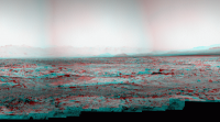
Damien's (Ant103) much better at seamless stitching of Navcam mosaics than I, but I just had to see this one ASAP.... so here's a quickly stitched anaglyph of the Sol 60 Navcam panorama. Gives a pretty good impression of the lay of things around MSL today. Phil's "sea lions" can be seen in this one too just above and to the right of the RUHF antenna. I'm fascinated by the long "petrified tree" looking formation on the ground in front of them. You can see it even better in the Sol 54 MC100 mosaic. What the heck is that? It looks for all intents and purposes like a fallen log...very strait, very long, and even looks very round...hmmm. Here's a closer look at it.

-------------------- "We shall not cease from exploration, and the end of all our exploring will be to arrive where we started and know the place for the first time." -T.S. Eliot
|
|
|
|
|
Oct 7 2012, 12:46 AM
Post
#49
|
|
|
Member Group: Members Posts: 276 Joined: 11-December 07 From: Dar es Salaam, Tanzania Member No.: 3978 |
MAHLI took a shot of the left middle and back wheels after inspecting the undisturbed ripple.
MAHLI sol 60 image Lots of small dents and scratches. Just caught scott's tweet saying the image above was to check if the mid wheel had been raised which would have made scooping an unstable process. -------------------- |
|
|
|
|
Oct 7 2012, 01:57 AM
Post
#50
|
|
 Senior Member Group: Members Posts: 4247 Joined: 17-January 05 Member No.: 152 |
QUOTE (EdTruthan @ Oct 7 2012, 01:29 AM)  It looks for all intents and purposes like a fallen log...very strait, very long, and even looks very round I'd say it's likely a flatish slab viewed end on, rather than a cyllinder. The "sea lions" probably are more slab-like than they look too.
|
|
|
|
|
Oct 7 2012, 02:08 AM
Post
#51
|
|
 Member Group: Members Posts: 691 Joined: 21-December 07 From: Clatskanie, Oregon Member No.: 3988 |
I second what Ed said, I'm sure Ant is gonna do a better job at this one, but here's mine.

|
|
|
|
|
Oct 7 2012, 02:43 AM
Post
#52
|
||
|
Member Group: Members Posts: 252 Joined: 5-May 05 From: Mississippi (USA) Member No.: 379 |
QUOTE (EdTruthan @ Oct 6 2012, 07:29 PM) I just had to see this one ASAP.... so here's a quickly stitched anaglyph of the Sol 60 Navcam panorama. Gives a pretty good impression of the lay of things around MSL today. That is certainly worth staring at. Trying to place the terrain from the orbital images with the panorama view. I have no trouble identifying "rocky point" - particularly if I look at the crater rim in the background. That gives me an additional check! Those 360 panoramas are handy orientation devices. However: In the North East direction, there is a somewhat circular depression that is possibly a crater or perhaps a deeply eroded basin in Glenelg. I can't really place it with the overhead view. A lot would depend on it's distance from MSL. Trying to tempt some Pano/orbilal comparisons. With the MERS we had programs that allowed distance information to be recovered from NAVCAM images, but I haven't used then for years and anyway the cameras are different. ~ North East Cropped section of Ed Truthan's Pano: edit corrected direction
|
|
|
|
|
|
|
Oct 7 2012, 08:46 AM
Post
#53
|
|
|
Senior Member Group: Members Posts: 3516 Joined: 4-November 05 From: North Wales Member No.: 542 |
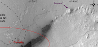
QUOTE (stewjack @ Oct 7 2012, 03:43 AM) Trying to tempt some Pano/orbilal comparisons. It would be great if someone could match visible features with Peter's map (see Geomorphology post 46), particularly the little 'island' at 137 27 05E, 4 35 32S which should be quite prominent. |
|
|
|
|
Oct 7 2012, 09:06 AM
Post
#54
|
|
|
Member Group: Members Posts: 691 Joined: 21-December 07 From: Clatskanie, Oregon Member No.: 3988 |
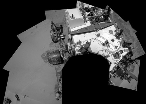
The deck on Sol-60.
|
|
|
|
|
Oct 7 2012, 09:28 AM
Post
#55
|
||
|
Senior Member Group: Members Posts: 2831 Joined: 22-April 05 From: Ridderkerk, Netherlands Member No.: 353 |
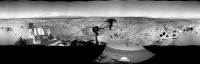
Sol 59-60
The Navcam R Panoramic view. Jan van Driel
|
|
|
|
|
|
|
Oct 7 2012, 01:43 PM
Post
#56
|
|
|
Senior Member Group: Members Posts: 3516 Joined: 4-November 05 From: North Wales Member No.: 542 |
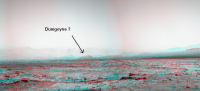
For referring to features in panoramas a few informal landmark names can be useful. We already have Rocky Point. Some of us probably have our own private names for things (or is it just me?). Here's one I'd like to share. For me there's only one possible name for the hill at the leftmost visible extremity of Mt Sharp. It's Dumgoyne: http://www.google.co.uk/imgres?imgurl=http...BA&dur=3713
|
|
|
|
|
Oct 7 2012, 02:42 PM
Post
#57
|
|||
|
Member Group: Members Posts: 252 Joined: 5-May 05 From: Mississippi (USA) Member No.: 379 |
QUOTE (ngunn @ Oct 7 2012, 08:43 AM) For referring to features in panoramas a few informal landmark names can be useful. We already have Rocky Point....... For me there's only one possible name for the hill at the leftmost visible extremity of Mt Sharp. It's Dumgoyne: ... Until, and unless, there is an official name that sounds good to me. If this is the overhead view of Dumgoyne it should remain in view in the N.E. for some time.
I couldn't find a good 2D horizontal view of Dumgoyne so I just marked it on my crop of EdTruthan's anaglyph.
|
||
|
|
|
||
|
Oct 7 2012, 03:30 PM
Post
#58
|
|
|
Senior Member Group: Members Posts: 1619 Joined: 12-February 06 From: Bergerac - FR Member No.: 678 |
Better for stitching panoramic, I don't know
 I think I'm always like a noob at made it. I think I'm always like a noob at made it.Sol 59 & 60 Navcam pan, with rover deck, Mount Sharp and natural sky. 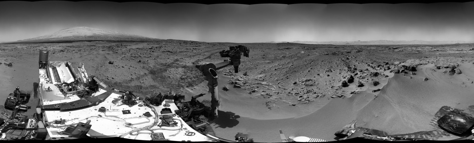
-------------------- |
|
|
|
|
Oct 7 2012, 03:39 PM
Post
#59
|
||
|
Solar System Cartographer Group: Members Posts: 10164 Joined: 5-April 05 From: Canada Member No.: 227 |
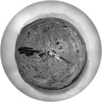
Beautiful! Here is a circular version of it.
Phil
-------------------- ... because the Solar System ain't gonna map itself.
Also to be found posting similar content on https://mastodon.social/@PhilStooke Maps for download (free PD: https://upload.wikimedia.org/wikipedia/comm...Cartography.pdf NOTE: everything created by me which I post on UMSF is considered to be in the public domain (NOT CC, public domain) |
|
|
|
|
|
|
Oct 7 2012, 04:22 PM
Post
#60
|
|
|
Senior Member Group: Members Posts: 3516 Joined: 4-November 05 From: North Wales Member No.: 542 |
QUOTE (stewjack @ Oct 7 2012, 03:42 PM) I couldn't find a good 2D horizontal view of Dumgoyne so I just marked it on my crop of EdTruthan's anaglyph. That's the one. It shows up rather well on this crop from Stu: http://www.unmannedspaceflight.com/index.p...st&id=28283 EDIT: Here's another view of the Scottish version showing the "crater rim" beyond: http://s0.geograph.org.uk/geophotos/02/48/...38_bd117844.jpg And back to Mars: http://mars.jpl.nasa.gov/msl-raw-images/ms...0000E1_DXXX.jpg |
|
|
|
|

|
Lo-Fi Version | Time is now: 21st May 2024 - 04:13 PM |
|
RULES AND GUIDELINES Please read the Forum Rules and Guidelines before posting. IMAGE COPYRIGHT |
OPINIONS AND MODERATION Opinions expressed on UnmannedSpaceflight.com are those of the individual posters and do not necessarily reflect the opinions of UnmannedSpaceflight.com or The Planetary Society. The all-volunteer UnmannedSpaceflight.com moderation team is wholly independent of The Planetary Society. The Planetary Society has no influence over decisions made by the UnmannedSpaceflight.com moderators. |
SUPPORT THE FORUM Unmannedspaceflight.com is funded by the Planetary Society. Please consider supporting our work and many other projects by donating to the Society or becoming a member. |
|