Post Conjunction: Santa Maria to Cape York, The Journey to 'Spirit Point' |

  |
Post Conjunction: Santa Maria to Cape York, The Journey to 'Spirit Point' |
 May 5 2011, 07:52 PM May 5 2011, 07:52 PM
Post
#316
|
||
|
Senior Member  Group: Members Posts: 2820 Joined: 22-April 05 From: Ridderkerk, Netherlands Member No.: 353 |
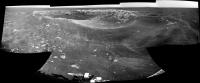
Sol 2586.
The Navcam L0 View of the FORTY LICKS Crater. Jan van Driel
|
|
 |
 
|
|
|
May 6 2011, 02:18 PM
Post
#317
|
|
 Senior Member Group: Members Posts: 4246 Joined: 17-January 05 Member No.: 152 |
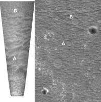
Farewell Mercury cluster?
http://qt.exploratorium.edu/mars/opportuni...0M1.JPG?sol2588 |
|
|
|
|
May 6 2011, 03:30 PM
Post
#318
|
|
|
Senior Member Group: Moderator Posts: 4279 Joined: 19-April 05 From: .br at .es Member No.: 253 |
They are now 125m far away on the rear mirror, and we should be reaching the 29km mark in two driving sols.
Edit: ... or even one. Tomorrow's driving might put Opportunity next to the traffic sign. Fingers crossed. This post has been edited by Tesheiner: May 6 2011, 04:25 PM |
|
|
|
| Guest_Sunspot_* |
May 6 2011, 03:35 PM
Post
#319
|
|
Guests |
I hope JPL make an event out of hitting 30km its a milestone that will deserve wider recognition in my opinion. I've noticed the NASA twitter feed rarely talks about planetary missions.
|
|
|
|
|
May 6 2011, 04:44 PM
Post
#320
|
||
|
Solar System Cartographer Group: Members Posts: 10151 Joined: 5-April 05 From: Canada Member No.: 227 |
Farewell Mercury cluster, hello weird circular features:
Phil PS - Scott tweets 160 m today - not too shabby! -------------------- ... because the Solar System ain't gonna map itself.
Also to be found posting similar content on https://mastodon.social/@PhilStooke Maps for download (free PD: https://upload.wikimedia.org/wikipedia/comm...Cartography.pdf NOTE: everything created by me which I post on UMSF is considered to be in the public domain (NOT CC, public domain) |
|
|
|
|
|
|
May 6 2011, 08:01 PM
Post
#321
|
||
 The Poet Dude Group: Moderator Posts: 5551 Joined: 15-March 04 From: Kendal, Cumbria, UK Member No.: 60 |
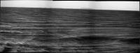
New pancams down = new drive direction panorama...
Hmmm... something bright and interesting on the horizon...  Will have to see what it lines up with on Google Mars... Will have to see what it lines up with on Google Mars... (larger version here: http://twitpic.com/4u8rj2/full ) -------------------- |
|
|
|
|
|
|
May 6 2011, 09:23 PM
Post
#322
|
||
|
Senior Member Group: Moderator Posts: 4279 Joined: 19-April 05 From: .br at .es Member No.: 253 |
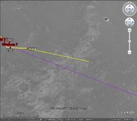
Saw that too. If I did my math correctly, it is heading at 102º so it might be this little fellow 450m away.
|
|
|
|
|
|
|
May 6 2011, 09:55 PM
Post
#323
|
|
|
Senior Member Group: Members Posts: 3516 Joined: 4-November 05 From: North Wales Member No.: 542 |
I haven't done any maths, but I'm looking at a feature about 1200m away. It looks like a sizeable crater (around 70m diameter) quite badly eroded but with a surprising amount of bright stuff showing.
|
|
|
|
|
May 6 2011, 10:27 PM
Post
#324
|
|
|
The Poet Dude Group: Moderator Posts: 5551 Joined: 15-March 04 From: Kendal, Cumbria, UK Member No.: 60 |
Pic, Nige?
-------------------- |
|
|
|
|
May 6 2011, 10:34 PM
Post
#325
|
|
|
Senior Member Group: Members Posts: 3516 Joined: 4-November 05 From: North Wales Member No.: 542 |
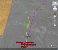
I don't do pics easily, but it's pretty prominent here: http://www.unmannedspaceflight.com/index.p...st&id=24273
Just go 1200m slightly S of E from the Mercury cluster. |
|
|
|
|
May 6 2011, 11:12 PM
Post
#326
|
||
|
The Poet Dude Group: Moderator Posts: 5551 Joined: 15-March 04 From: Kendal, Cumbria, UK Member No.: 60 |
You're getting really good at this crater-spotting lark, Nigel...
 I asked Ray Arvidson what it was: "Yes it is off about 1 km at an azimuth of 102 deg from the current rover position." Sounds like your crater. Edit: Bit confused now... 1km / 102 deg from current position =

-------------------- |
|
|
|
|
|
|
May 7 2011, 03:13 AM
Post
#327
|
|
|
Solar System Cartographer Group: Members Posts: 10151 Joined: 5-April 05 From: Canada Member No.: 227 |
"1km / 102 deg from current position ="
Yes, but what about "about 1 km..."? The fresh-looking crater is 'about' 1 km away, just not exactly 1 km away. And that crater may be the true identity of 'Young Blocky' as well. Phil -------------------- ... because the Solar System ain't gonna map itself.
Also to be found posting similar content on https://mastodon.social/@PhilStooke Maps for download (free PD: https://upload.wikimedia.org/wikipedia/comm...Cartography.pdf NOTE: everything created by me which I post on UMSF is considered to be in the public domain (NOT CC, public domain) |
|
|
|
|
May 7 2011, 05:13 AM
Post
#328
|
||
 Senior Member Group: Members Posts: 2228 Joined: 1-December 04 From: Marble Falls, Texas, USA Member No.: 116 |
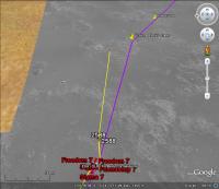
I've taken Stu's image and added a green arrow pointing to the crater that I think Nigel is talking about. It could be the bright patch we see near the horizon, but the bearing to it in Google Mars is 96 degrees. That's quite a bit off from the 102 degrees that Ray said it was. 102 degrees is also the bearing that Midnight Mars Browser gives for the bright patch.
I know the base HiRise images we are using in Google Mars for the route map are offset somewhat from Google's underlying frame of reference. I don't think an offset alone would cause errors in bearing, but if our map is rotated it could.
-------------------- ...Tom
I'm not a Space Fan, I'm a Space Exploration Enthusiast. |
|
|
|
|
|
|
May 7 2011, 07:27 AM
Post
#329
|
|
|
Senior Member Group: Moderator Posts: 4279 Joined: 19-April 05 From: .br at .es Member No.: 253 |
QUOTE (CosmicRocker @ May 7 2011, 07:13 AM)  I know the base HiRise images we are using in Google Mars for the route map are offset somewhat from Google's underlying frame of reference. I don't think an offset alone would cause errors in bearing, but if our map is rotated it could. The offset is because I registered this latest package of HiRISE images to the previous one covering SM which was also offset in relation to the background. There was no rotation on it, except for the one already existing in the original picture on its map-projected form. |
|
|
|
|
May 7 2011, 07:52 AM
Post
#330
|
|
|
Senior Member Group: Members Posts: 3516 Joined: 4-November 05 From: North Wales Member No.: 542 |
QUOTE (CosmicRocker @ May 7 2011, 06:13 AM) the crater that I think Nigel is talking about You're right, that was my guess, but it doesn't seem to square with the azimuth so now I just don't know. We had azimuth problems with Santa Maria as well did we not? It will be interesting to see how this resolves itself. |
|
|
|
|

|
Lo-Fi Version | Time is now: 26th April 2024 - 07:42 AM |
|
RULES AND GUIDELINES Please read the Forum Rules and Guidelines before posting. IMAGE COPYRIGHT |
OPINIONS AND MODERATION Opinions expressed on UnmannedSpaceflight.com are those of the individual posters and do not necessarily reflect the opinions of UnmannedSpaceflight.com or The Planetary Society. The all-volunteer UnmannedSpaceflight.com moderation team is wholly independent of The Planetary Society. The Planetary Society has no influence over decisions made by the UnmannedSpaceflight.com moderators. |
SUPPORT THE FORUM Unmannedspaceflight.com is funded by the Planetary Society. Please consider supporting our work and many other projects by donating to the Society or becoming a member. |
|