Printable Version of Topic
Click here to view this topic in its original format
Unmanned Spaceflight.com _ Spirit _ Sol581: Spirit Arrived!
Posted by: dilo Aug 22 2005, 06:20 AM
Wow, take a look!!!!!!
there is also a magnificent DD!
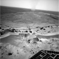
|
|
Posted by: dilo Aug 22 2005, 06:31 AM
And this is the first stich of the NEW EAST HORIZON!
(I will improve it...)

|
Posted by: Tesheiner Aug 22 2005, 06:42 AM
Wow!
What a beast DD. 
Posted by: akuo Aug 22 2005, 06:47 AM
Whoa, what a view! I actually gasped when I saw that dustdevil.
Congrats to the team for reaching the top!
Posted by: jamescanvin Aug 22 2005, 06:50 AM
Wow, just about there! What a fantastic achevement!
Posted by: Tman Aug 22 2005, 06:53 AM
Boahh!!! Thats phenomenal  look at that track!
And Ladies and gentlemen: We proudly present The Summit! 
This lookout is absolutely marvellous...
Also congratulations to the MER team!
Posted by: general Aug 22 2005, 06:58 AM
Awesome! 
Posted by: slinted Aug 22 2005, 07:11 AM
This is truely an unbelievable achievement for the MER team. Cresting the hill, with Thira crater is in full view to the east, as that beast of a dust devil goes cruising by and untold more sights to see yet to come. This is quite a moment...
Posted by: Tesheiner Aug 22 2005, 07:19 AM
I'm still hypnotized by this view...
What do we see at the far horizont? Is it Gusev crater rim?
http://nasa.exploratorium.edu/mars/spirit/navcam/2005-08-21/2N177951106EFFADNDP0645R0M1.JPG
Posted by: general Aug 22 2005, 07:35 AM
What do we see at the far horizont? Is it Gusev crater rim?
http://nasa.exploratorium.edu/mars/spirit/navcam/2005-08-21/2N177951106EFFADNDP0645R0M1.JPG

Isn't that the rim of Thira crater?
http://www.sondasespaciales.com/public/imagenes/galerias/mers/mer_040604/odyssey_vista_aerea.jpg
Posted by: slinted Aug 22 2005, 07:49 AM
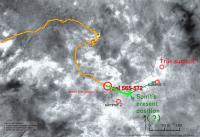
Here is a portion of an overlay of the MEX HSRC color, on THEMIS images, showing the area north and east of the Columbia Hills. That "small" triangle in the lower left are the Columbia Hills. The 22 km diameter crater northeast is Thira Crater. We've seen parts of it before, from in between the peaks as Spirit was climbing, but I think the navcam images from sol 581 are the first full view of it.
http://www.lyle.org/~markoff/collections/gusev/thira_hsrc_themis.jpg
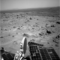
Posted by: jvandriel Aug 22 2005, 08:26 AM
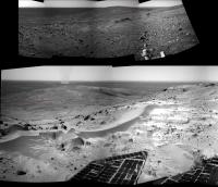
Spirit looking around on the summit of Husband Hill.
A spectacular view to the south and also a big dust devil.
Taken on Sol 581 with the L Navcam.
This is part of a 360 degree panorama. The rest will follow. ( I hope ).
jvandriel

|
Posted by: MichaelT Aug 22 2005, 08:53 AM
Hi,
what a great day!!! Finally on the summit 
This is the 3D-Version of the panorama, generated from MMB anaglyphs (800 kB):
http://www.muk.uni-hannover.de/~theusner/mars/2NA_pan_581_02.jpg
Michael
Posted by: malgar Aug 22 2005, 09:08 AM
what a great day!!! Finally on the summit
This is the 3D-Version of the panorama, generated from MMB anaglyphs (800 kB):
Michael
Michael, this 3D version is awesome!
How many sols (and days) from West Spur has taken Spirit to reach the summit?

Posted by: ustrax Aug 22 2005, 09:19 AM
Spirit is the queen of the hill!!!
Let me be the fool just aside her...
Just a suggestion, as we know that MERs are amazing ladies why not giving some rock or feature the name of the first woman climbing Everest? Junko Tabei, of Japan, in 1975.
Posted by: edstrick Aug 22 2005, 09:29 AM
Isn't it nice that the ground right in front of the rover to the north in complex and visually interesting.. the near-ground to the east and south is much blander and less photogenic.
When we go to the south shoulder of the hill for a better view into the hollow to the south, I hope we're as lucky with a good foreground view.
Posted by: MichaelT Aug 22 2005, 09:36 AM
If I remember it right, Spirit reached the base of Husband Hill around Sol 190. So, it took her 390 Sols = 400 Days, more than a year!
Some people here, including me, hoped for a nice DD in the background - and what did we get?!
Could it have gotten any better?
Michael
Posted by: jvandriel Aug 22 2005, 09:44 AM
MichaelT,
not 1 but 2 dust devils.
You must be a lucky guy.
jvandriel
Posted by: Reckless Aug 22 2005, 09:55 AM
I've just seen the view from the top brilliant. I think you can make out the three high points on the near side of Thira crater.
Well done to everyone.
And there is so much more to come on the south side 
Roy F
Posted by: Bob Shaw Aug 22 2005, 10:16 AM
After Homeplate, I vote for a quick run over to Thira - there's some hills need climbing!
(BTW, anyone spot the *shadow* of the DD? Wow!)
Posted by: edstrick Aug 22 2005, 10:22 AM
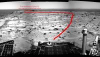
Stealing JVandriel's panorama's central half... Here's a proposed route <not including a possible jog to the south shoulder of the hill for a first overlook into the South Hollow> of a traverse to the second summit for an overlook into the Northeast Hollow. The geology there is distinctive and interesting in MOC image data and would well be worth a trip to check out if the South Hollow and Home Plate weren't even better.
So we'd better get a good look that direction.. may be very useful, even possibly essential in understanding the geologic structure and origin of the hills.
|
Posted by: Nix Aug 22 2005, 10:27 AM
All right! we'll probably see a dozen more pans from this location but here goes.
http://www.awalkonmars.com/A1581NAM8L0R0E1v1.jpg
http://www.awalkonmars.com/A1581NAM8L0R0E1v2.jpg
Nice to share this joy with all of you guys!
Nico
Posted by: ustrax Aug 22 2005, 10:49 AM
Nico...That is breathtaking!
edstrick, what's the idea?!
Full steam ahead to the South Basin, Ultreya and Homeplate!!!

Posted by: Bob Shaw Aug 22 2005, 10:57 AM
I'm intrigued by the serpentine sand/dust dunes on the edge of the plateau - presumably they indicate the historical direction of the prevailing winds. However, on Earth it's more common to see a bare and rocky summit (even on a flat top) than dunes on the apex of the hill. If the dunes are local in origin, does this mean they are very old, perhaps?
Posted by: edstrick Aug 22 2005, 10:58 AM
They *CANT*... As Squyres points out.. every day is maybe the last... They're gonna do a rock survey on top of the hill to be sure they aren't different from anything so far.... they very well could be..
The view to the northeast will be as good as this one.. and very different terrain we'll almost certainly never visit.
We can get a first look over the shoulder to the south on the way over to Summit 2.... and I'd strongly prefer an east-then-south route down into the basin.. the layered looking ridges and shelfs of rock they'll pass on the route down may be very important geologically.. and it will give a far better view and approach to the "ultreya" sand sheet than an approach from the west.
The whole east route gives more interesting and more likely different geology than we've seen than a climb down the hill to the west and a loop around the south side into the southern hollow.
I agree with the goal.. I don't think the sand sheet is that important, but it's a fundamental surficial unit type we should look at, if only for future engineering knowledge.. we're gonna have to be able to cross them... My goal is home plate.. I keep thinking that thing is a playa type salt deposit in a hollow that's now partly eroded away from around it.. .... maybe...
Beyond Home plate.. if we get there....... It's either the summit of the next hill to the south, or extensive exploration of the hollow.. there's oodles of weird geology I can half see in the MOC images.... all depends on rover condition and seasonal power availibility.
Posted by: ustrax Aug 22 2005, 11:12 AM
The view to the northeast will be as good as this one.. and very different terrain we'll almost certainly never visit.
We can get a first look over the shoulder to the south on the way over to Summit 2.... and I'd strongly prefer an east-then-south route down into the basin.. the layered looking ridges and shelfs of rock they'll pass on the route down may be very important geologically.. and it will give a far better view and approach to the "ultreya" sand sheet than an approach from the west.
The whole east route gives more interesting and more likely different geology than we've seen than a climb down the hill to the west and a loop around the south side into the southern hollow.
I agree with the goal.. I don't think the sand sheet is that important, but it's a fundamental surficial unit type we should look at, if only for future engineering knowledge.. we're gonna have to be able to cross them... My goal is home plate.. I keep thinking that thing is a playa type salt deposit in a hollow that's now partly eroded away from around it.. .... maybe...
Beyond Home plate.. if we get there....... It's either the summit of the next hill to the south, or extensive exploration of the hollow.. there's oodles of weird geology I can half see in the MOC images.... all depends on rover condition and seasonal power availibility.
Sorry edstrick...My english betrayed me, I thought you were suggesting ignoring COMPLETELY the south and take the east the only priority...
Posted by: MahFL Aug 22 2005, 11:19 AM
Wow !, its like Spirit just landed and started a new mission. The view is breathtaking.
Posted by: edstrick Aug 22 2005, 11:22 AM
<Nods at Ustrax>... No problem.
Bob Shaw: "I'm intrigued by the serpentine sand/dust dunes on the edge of the plateau - presumably they indicate the historical direction of the prevailing winds. However, on Earth it's more common to see a bare and rocky summit (even on a flat top) than dunes on the apex of the hill. If the dunes are local in origin, does this mean they are very old, perhaps? "
The serpentine dune-let? ... dune-ino?.... mini-dune?.. NANO-Dune!... <...needs to go to bed....> is essentially identical in general form to the one on the south or southeast rim of Eagle crater. Both are apparently results of prevailing wind direction and prevailing sand or whatever transport. There were some on the south rim of Bonneville, too.... Stuff is carried up the slope close to the surface and when the windflow detaches from the surface and probably becomes turbulent at the topographic break... voila... serpentine ripples.
The dark sand sheets on the northwest inside wall of Bonneville, and the ones we can see on the southeast flanks of the hill(s) to the north.. and the big "Ultreya" sand sheet on the southeast are another result of the same transport process, I suspect. I think we ought to take a quick look at the composition of the soil in these dunelets to compare with the big sheet at "ultreya".. there may be interesting physical and minerological property differences, if only due to what seems to be very complex patterns of eolian sorting of materials.
Posted by: MichaelT Aug 22 2005, 11:27 AM
Not necessarily. I think that these little ripples right on the edge are just what I would expect if you had up-slope winds. The quite sudden transition from the steep slope to the plateau would lead to the formation of a vortex right behind that edge, causing dust deposition right there. If you had a more rounded mountain top, the airflow would be more laminar and such ripples would not be present. On Earth you often find similar structures on snow-covered mountains.
Michael
Posted by: Tman Aug 22 2005, 11:49 AM
That view is worth an extra shift!
A bit color change again. I'm still unsatisfied about contrast and conservation of details in my pans, but the (my) clearing of the lens vignetting degrades it always. 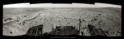
(1,9 MB) http://www.greuti.ch/spirit/spirit_navcam_sol581.jpg
Posted by: paxdan Aug 22 2005, 11:53 AM
yeeesssssss
Posted by: jvandriel Aug 22 2005, 11:57 AM
Edstrick,
I think you can not reach the end of that overlook ( Bryce Point ).
When you look at the 3D panorama from MichaelT, you can see that there are
at least 2 gullys in it.
I can not see how deep they are.
jvandriel
Posted by: Nix Aug 22 2005, 11:59 AM
I was waiting for yours Tman! Awesome.. if you care to do the other eye like this you have a one-million-dollar anaglyph! Please?
Nico
Posted by: edstrick Aug 22 2005, 12:02 PM
I'm unable to do 3-D stereo pairs at all.... Left eye is 20/200 due to amblyopia... I think there may be a route........ we can see better when we wander off to the east after finishing this outlook.
And, Oh... think of the 3-D view of the hills to the north with a stereo-baseline between the two summits!
Posted by: djellison Aug 22 2005, 12:05 PM
Nicely done on the matching there Tman - a beauty
Doug
Posted by: general Aug 22 2005, 12:20 PM
So we'd better get a good look that direction.. may be very useful, even possibly essential in understanding the geologic structure and origin of the hills.
I'm a bit lost here...
Since Spirit is looking towards the east in that picture (Thira crater at the horizon), 'summit 2' should be behind Spirit.
I'm convinced she's sitting on the crest somewhere between 'summit 1' and 'summit 2', and that it is 'summit 1' we're seeing.

|
Posted by: tedstryk Aug 22 2005, 12:30 PM
This might be the pan ever!
Posted by: ustrax Aug 22 2005, 01:03 PM
Maybe not 100% accurate but...what is the teamwork for?...
http://i16.photobucket.com/albums/b14/ustrax3/references.jpg
Posted by: Pertinax Aug 22 2005, 01:26 PM
Is my understanding correct in thinking that Husband Hill is thought to be the highest in these hills? It came as a little suprise to me to see McCool and Ramon hills still 'looming' taller in sol581's NavCam shots. (http://207.7.139.5/mars/spirit/navcam/2005-08-21/2N177951296EFFADNDP0645R0M1.JPG)
I agree that we still have some small vertical distance still to climb to be at least very near the maximum vertical extent of Husband Hill (http://207.7.139.5/mars/spirit/rear_hazcam/2005-08-21/2R177950900EFFADNDP1312L0M1.JPG), but not enough it seems to be able to peak over either McCool or Ramon hills.
This is not a diminishment of Spirit's (nor her controlers') fantastic effort -- Onwards and Upwards!
-- Pertinax
Posted by: Burmese Aug 22 2005, 01:26 PM
Looking at that overhead of Thira and the Columbia Hills it seems that Spirit really plopped down in Dust Devil Alley. Other parts of Gusev seem devoid of DD tracks. Perhaps that area is the 'sweet spot' where the wind passing over and through the crater has just the right amount of turbulence to promote DD development. Had Spirit landed elsewhere in Gusev, she might still be searching for shows of DD's.
Posted by: paxdan Aug 22 2005, 02:38 PM
edstrick - there is a 3D technique i have seen which is very rarely employed which i would guess is called something like 'waggle 3D'. essentially you make an animated gif that flicks between the two images, left cam right cam, and at a certain frequency your brain perceived the depth. It should give the perception of depth even when looking with only one eye because the perception of depth comes not from have two different static images the require you to look with both eyes simultaneously but from your brain interpreting the relative differences in the offset as motion/depth. i.e., the images look like little 3D models being rotated.
In fact i've seen waggle 3D images on somebodies mars blog....
Posted by: AndyG Aug 22 2005, 03:08 PM
Hi Pertinax...I've seen the same effect on Earth.
I was up Scafell Pike years ago - this is England's highest hill at 977 metres. A kilometre away, the nearby summit of Sca Fell (964 m) clearly looked higher than I was because it jutted above the horizon.
Remember that on a summit, the horizon of a curved planet is below the true horizontal. It's 1 degree from Scafell Pike, 0.44 degrees from a 100m tall Husband Hill on Mars.
I put it down to our brains playing tricks, since our (generally) ground-based experience is that anything which appears above a horizon must be higher than our own vantage point.
Andy G
Posted by: Deimos Aug 22 2005, 03:11 PM
The problem is that Mars isn't flat--curvature is more of a factor than for Earth. Curvature pushes down the distant horizon. So, a nearby hill that is almost as tall as your vantage point appears just a little greater than 90 deg below zenith. A 70 km distant hill, even if much taller, can appear more than 90 deg below the horizon. I haven't done the math in this case, but I've seen the affect on Earth, and it'll be bigger on mars.
Posted by: Bill Harris Aug 22 2005, 03:13 PM
Michael
The dunes surprised me. On the climb to the top, we've been seeing increasingly wind-scoured terrain and I wasn't expecting to see deep and widespread dunes. I have a concern about hazardous footing due to loose sand, here on the top of the hill but especially on the downwind south side of the hill. I hope we won't run into problems on this next leg of our adventure.
--Bill
Posted by: Pertinax Aug 22 2005, 03:19 PM
Doh!
Deimos and Andy, thank you both -- you are 100% correct. I feel a little silly not having thought of that.
My main personal reference point was my time working on New Hampshire's Mt. Washington, where all the surrounding summits were well below the horizon. But, there the adjecent peaks were both close (within several miles) and ~500 -~900 feet lower in elevation.
Thank you again.
-- Pertinax
Posted by: Deeman Aug 22 2005, 04:32 PM
Just noticed the great news. Workday ends, evening fun starts Smile Smile Smile
Dirk
Posted by: remcook Aug 22 2005, 04:41 PM
absolutely amazing!
Posted by: RNeuhaus Aug 22 2005, 07:35 PM
Bob,
You are right.
This happens the same to me. There are plenty of sands on the top of mountain.
That is a strange thing. This deduces that the Martian sand can pose at much higher altitude than on the Earth due to the fact that the sand is very light along with strong wind and also with the force of dust devils along with the wind trappers by the special landforms and rocks.Rodolfo
Posted by: dilo Aug 22 2005, 07:40 PM
Using MMB slideshow, is sufficient to rapidly switch with left/right buttons without making animated gif (very efficient!)...
Anyway, I tried to measure some parallax distances:

|
PS: great panorama, Tman!
Posted by: babakm Aug 22 2005, 07:47 PM
Just a guess here, but the sand could've been funneled up Tennessee Valley (which roughly inline with the DD tracks in MGS images) and then deposited at the flat area around the peak.
Posted by: edstrick Aug 22 2005, 08:25 PM
Paxdan: "In fact i've seen waggle 3D images on somebodies mars blog"
It works.. In ACDSee I can select two images and rapidly toggle between them, but it's not the real thing.. but it helps.
Posted by: ElkGroveDan Aug 22 2005, 11:01 PM
Hey Spirit, your sister Oppy called long distance from Meridiani while you were busy uplinking. She says stay clear of that sand.
(She also wants to know what remedy you used on that stiff joint that was bothering you earlier this year.)
Posted by: alan Aug 22 2005, 11:51 PM
Another drive coming up and a pan of Tennessee Valley
4. What EDRs did we request?
Expected EDRs by sequence number and image type:
Sol Seq.Ver ETH ESF EDN EFF ERP Tot Description
--- -------- --- --- --- --- --- ---- -----------
582 p0695.03 10 0 0 10 0 20 navcam_5x1_az_162_3_bpp
582 p0795.03 10 0 0 10 0 20 navcam_5x1_az_342_3_bpp
582 p1201.14 2 0 0 2 0 4 front_haz_penultimate_1_bpp_crit_27
582 p1214.05 2 0 0 2 0 4 front_hazcam_ultimate_4_bpp
582 p1301.01 2 0 0 2 0 4 penultimate_rear_hazcam_pri_27
582 p1312.09 2 0 0 2 0 4 ultimate_rear_hazcam_2_bpp_pri15
582 p1586.00 4 0 4 0 0 8 navcam_cloud_4x1_dwnsmp_RVRAz330
582 p2124.03 3 3 0 0 1 7 pancam_cal_targ_L456
582 p2299.03 54 0 0 54 1 109 pancam_tennessee_valley_6cx3r_L456
Posted by: alan Aug 23 2005, 01:16 AM
nice view of Thira
http://qt.exploratorium.edu/mars/spirit/pancam/2005-08-22/2P177953098EFFADNDP2369R1M1.JPG
Posted by: mhoward Aug 23 2005, 01:41 AM
http://midnightmarsbrowser.blogspot.com/2005/08/spirit-sol-581-pancams-summit-view.html
I think this one is incredibly "artistic": http://nasa.exploratorium.edu/mars/spirit/pancam/2005-08-22/2P177952569EFFADNDP2369L7M1.JPG.
And wow, we sure are seeing the horizon a lot clearer than in the earlier navcams...
Posted by: mhoward Aug 23 2005, 03:18 AM
Here are a couple anaglyphs from tonight's IRC chat on the #space channel:
http://www.flickr.com/photo_zoom.gne?id=36394993&size=o
http://www.flickr.com/photo_zoom.gne?id=36396316&size=o
Posted by: GADean Aug 23 2005, 04:15 AM
What an exciting event! Too bad Spirit had to arrive at the summit in such an undignified manner (butt first.) Like General, it looks to me like we are looking towards Summit 1 at the moment, and perhaps some slightly higher terrain beyond it. Even so, Spirit cannot be more than a few feet below the "true summit" at this point.
As much as we all anticipate the views into the southern valley, the view down the eastern flanks of Husband look pretty tantalizing. That rocky valley on the otherside of the crest from Tennessee, that is just visible in the latest PanCams, does it have a name yet? I'm trying to find some of the labeled overhead images but coming up empty at the moment.
MHoward's pancam stich shows the rocky valley leading down towards the southeast (or so it appears.)
http://flickr.com/photo_zoom.gne?id=36375879&size=o
Posted by: CosmicRocker Aug 23 2005, 04:53 AM
(She also wants to know what remedy you used on that stiff joint that was bothering you earlier this year.)
ElkGroveDan: Good one!
I suspect the remedy was the same one my Dad often recommended to me..."Spit on it, and walk a mile."
Posted by: CosmicRocker Aug 23 2005, 05:08 AM
It's a quite different view in 3D. Spirit will need to continue to move carefully.
Posted by: dilo Aug 23 2005, 05:47 AM
Wow, the 3D dustdevil view is absolutely breathtaking!
I tried to colorize the four-Pancam mosaic toward Thira and make more accurate distances measurement around Summit1:

|

|
(one of my previous summit distances on NavCam images was strongly understimated, I apologize for this...)
Posted by: dilo Aug 23 2005, 06:28 AM
Playng with a portion of Tman's Panorama in order to enhance DD... did someone noticed we are looking to Methuselah in the center/right? how is far now!!!

|
crossed-eyed stereogram:

|
Posted by: glennwsmith Aug 23 2005, 06:55 AM
God, what a vista -- with a giant, shadow-casting DD (no doubt about this one being visible from orbit, DJ) dead center! Congratulations to the MER team, and thanks to the members of this forum for having someone to share the excitement with! Glenn
And we really need to come up with a better term than "dust devil" -- that monster is bigger than many earthly tornadoes, I would suspect.
Posted by: Tesheiner Aug 23 2005, 06:56 AM
Dilo,
Yesterday I was just enjoying the view and thought the same thing: Larry's Lookout!
But then, after reviewing older panoramas I realized I was wrong. Methuselah and Larry's Lookout must be out of view, to the left of current pano. 
Here you have a comparision between sol 453 and sol 481 panoramas with some reference lines added.
|
Posted by: Tman Aug 23 2005, 07:18 AM
Dilo, today I extra rose with the sun in hope for first Pancams (yawn) But you are ever already ready Very nice works!
Thira crater: (1,0 MB) http://www.greuti.ch/spirit/spirit_panL7_thira_sol581.jpg
Sodding-dust! 

Tes, hoping we drive this part still forward. I want look at the Larry and Meth!!!
Posted by: helvick Aug 23 2005, 07:45 AM
Horizon distance (excluding any atmospheric effects) = sqrt((R+h)^2-r^2) where r is the diameter of the planet and h is the observers height above the surface. This is the same formula used to measure the drop off due to distance on a spherical surface.
For your example (a hill that's 70km away) The difference in elevation on Mars is ~720m while on Earth it's 385m.
Posted by: aldo12xu Aug 23 2005, 07:47 AM
Hey Tman, I used your first panorama from sol 581 on my site to show horizon features relative to orbiter images. I hope you don't mind that I did my poor man's version of colourizing it and that I stetched it 5 times out of shape and made those dust devils look like gysers!! 
It's under "Gusev Horizon"
Posted by: general Aug 23 2005, 10:08 AM
Latest panorama (sol582)
(made with Autostitch - anyone any idea how I could straighten the horizon?)
|
|
Posted by: Tesheiner Aug 23 2005, 10:23 AM
General,
See another "instance" of the panorama http://www.unmannedspaceflight.com/index.php?showtopic=1294&view=findpost&p=17907.
anyone any idea how I could straighten the horizon?
Yes and no. You can play with Phi and Psi parameters, but you won't get a really flat horizont if the images are incorrectly stitched. And this is what happens with autostitch when you have near and far features on the same images; the program "takes preference" for the ones near the rover and due to parallax effects you get a discontinuity/disalignment at the horizont.
Posted by: MaG Aug 23 2005, 11:39 AM
http://qt.exploratorium.edu/mars/spirit/pancam/2005-08-22/2P177953098EFFADNDP2369R1M1.JPG
First time I saw the image from near summit location, I think, there is no Gusev rim. But now I see this image, and except the Thira rims I saw some very hazy up it. So Gusev rim is there, isnt it?
Posted by: general Aug 23 2005, 12:01 PM
Or it could be the 'far-side' rim of Thira crater.
Posted by: Bob Shaw Aug 23 2005, 12:07 PM
Very nice works!Thira crater: (1,0 MB) http://www.greuti.ch/spirit/spirit_panL7_thira_sol581.jpg
Sodding-dust!
Tes, hoping we drive this part still forward. I want look at the Larry and Meth!!!
Am I seeing *bedding* here?
Posted by: jvandriel Aug 23 2005, 12:11 PM
A complete 360 degree horizon panorama from the summit of Husband Hill.
Made with the L Navcam on Sol 582.
As soon as the rest of the data is in, I will make a complete new one.
jvandriel
|
|
Posted by: jvandriel Aug 23 2005, 12:59 PM
Tesheiner,
for making perfect panorama pictures, the camera must rotate around the vertical axis.
But the left or right Navcams on Spirit are not rotating around their vertical axis, but
around the vertikal axis of the boom on which they are mounted.
Therefore the result wil not be perfect.
When the camera boom of Spirit is rotating for making panorama,s the camera will be
displaced between the exposures.
You can try to get better results by changing the Ransac and Sift image parameters.
For straitening the horizon change the Phi parameter in Autostitch.
jvandriel
Posted by: Nix Aug 23 2005, 01:23 PM
I've been tremendously enjoying all the good work on this scene, including the latest Navcam pans! Is this a panoparty or what?
About the rim of Gusev; it's there allright but I've had some work -trying- to bring it out as good as possible. I've had some slight differences selecting it in L7 and R1.
I also had to give up some contrast for hiding the seems between a couple of frames...gives a dusty feel to the scene.
I might redo it, I'll see.
http://www.awalkonmars.com/A1581PAM8L7R1E1v1.jpg
Nico
Posted by: ustrax Aug 23 2005, 01:32 PM
About the rim of Gusev; it's there allright but I've had some work -trying- to bring it out as good as possible. I've had some slight differences selecting it in L7 and R1.
I also had to give up some contrast for hiding the seems between a couple of frames...gives a dusty feel to the scene.
I might redo it, I'll see.
Nico
WOOOOW!!! NIX...That would goes straight to the wall (I can print it the size I want...How about...3 meters?...
Posted by: Tman Aug 23 2005, 03:24 PM
Hey Nico you party-guy Your dust-filter is amazing! Thats a lot of work in the image I guess, thanks!
Posted by: djellison Aug 23 2005, 03:26 PM
A bit color change again. I'm still unsatisfied about contrast and conservation of details in my pans, but the (my) clearing of the lens vignetting degrades it always.
(1,9 MB) http://www.greuti.ch/spirit/spirit_navcam_sol581.jpg
Mind if I use this in an article for Spacedaily.com ? Full credt will be given..
Doug
Posted by: Tman Aug 23 2005, 03:31 PM
Doug
Yes, show them the great success of Spirit! Btw. my full name is Peter Greutmann
Posted by: djellison Aug 23 2005, 03:53 PM
Thanks
Doug
Posted by: dilo Aug 23 2005, 06:14 PM
Yesterday I was just enjoying the view and thought the same thing: Larry's Lookout!
But then, after reviewing older panoramas I realized I was wrong. Methuselah and Larry's Lookout must be out of view, to the left of current pano.
Here you have a comparision between sol 453 and sol 481 panoramas with some reference lines added.
Damn, you're right... Phil, this is the homeplate sindrome!
Posted by: Nirgal Aug 23 2005, 07:05 PM
here is a first color interpretation of jvandriel's 360er
(not perfect, because the high contrast stretching in this navcam series
makes colorizing even more difficult ... but anyway, here is my
first contribution to the pano-party
I also corrected the dark vignette "banding" and roughly "patched" the
"black hole" of the missing image data
http://mitglied.lycos.de/user73289/misc/spirit_n581p.jpg
... just can't wait to see the first true-color pancam's
BTW: I have written a small utility program to automatically correct
the "dark stripes" in panorama stitches (it uses an adaptive filter and works even on the final "banded" mosaic without doing the vignette correcting first for individual frames)
If you are interested I can put a version of the proggy online so anyone can quickly de-stripe existing navcam-panoramas
Posted by: djellison Aug 23 2005, 07:16 PM
The L456 of Tennesse is down
Doug
Posted by: Nix Aug 23 2005, 07:22 PM
YeeeeeeeeeeeeeeeeeeeeeeeeeeeeeeeeeeeeeeeHA ! more work...
Way to go Nirgal!
Nico
Posted by: Nix Aug 23 2005, 07:39 PM
Oh..it's going to be a though one to match
Posted by: Phil Stooke Aug 23 2005, 07:45 PM
The feature which looks like Larry's Lookout/Methuselah in Dilo's reply #61 is actually a similar feature on the opposite side of Tennessee Valley. When Spirit first arrived in the Paso Robles/Methuselah area it saw that ledge in cross-section on the far side of the valley. There seem to be lots of them, every one a new outcrop!
Phil
Posted by: aldo12xu Aug 23 2005, 07:48 PM
Wow, Nirgal, great job!! I especially like how the rocks in the foreground turned out.
As for that program, I sure could use it, as my feeble attempts at cleaning up the vignetting never worked out. What's the basic procedure invloved in using your program?
Thanks again for your contribution.
Posted by: Nirgal Aug 23 2005, 08:10 PM
As for that program, I sure could use it, as my feeble attempts at cleaning up the vignetting never worked out. What's the basic procedure invloved in using your program?
Thanks again for your contribution.
it is still a part of my larger "graphics development studio" (several megabytes and lots of external libraries)... but I'm planning to
isolate the vignette-auto-corrector part as a small stand-alone tool.
as such it won't have any GUI but be as simple as typing on the command line (DOS prompt)
>stripfix image.png output_image.png
in an earlier version, one had to specify a "reference line" in a uniformly bright area of the image (sky) but I have rewritten the adaptive filter to automatically track the sky so the only (optional) parameter to specify is a "smoothing constant" for the filter ...
... more in the tech&imagery board
Posted by: jvandriel Aug 23 2005, 08:23 PM
Here is the first complete 360 degree panoramic view from Husband Hill.
Taken with the R0 Navcam on Sol 582.
A great view. Congratulations to the Rover Team.
jvandriel
|
|
Posted by: Tesheiner Aug 23 2005, 09:00 PM
YESSSSSSSSSSSSS!!!!!!!
Posted by: garybeau Aug 23 2005, 10:48 PM
Wow, look at the wind erosion on those rocks, wish we had a wind sock on Spirit - or better yet, what a great place to plant a flag.
http://marsrovers.jpl.nasa.gov/gallery/all/2/n/582/2N178037831EFFAE00P0795R0M1.JPG
Posted by: Bob Shaw Aug 23 2005, 11:01 PM
http://marsrovers.jpl.nasa.gov/gallery/all/2/n/582/2N178037831EFFAE00P0795R0M1.JPG
Goodness! You're right! I don't think we've ever seen anything like that before in Gusev! A set of those little Pathfinder wind-socks would have been just the thing, too...
(Nobody say 'tree trunks' or 'petrified wood'. OK?)
Posted by: djellison Aug 23 2005, 11:11 PM
I've given up - it's just TOO hard to get this lot to match - I'm sure someone else will figure it out, but I'll wait for the RADS 
http://www.unmannedspaceflight.com/doug_images/582_trash.jpg 400kb
Posted by: Nirgal Aug 24 2005, 12:09 AM
As for that program, I sure could use it, as my feeble attempts at cleaning up the vignetting never worked out. What's the basic procedure invloved in using your program?
Thanks again for your contribution.
ok, I'm still testing the program and optimizing the filter algorithm.
Here is an example, using this beautiful 360 degree pano
(thanks a lot to jvandriel for stitching and posting this !)
this is the original version with some visible vignette striping
http://mitglied.lycos.de/user73289/misc/pano_striped.jpg
this as output of the "unstrip" program (just with auto-settings, no fine-tuning)
http://mitglied.lycos.de/user73289/misc/pano_unstriped.jpg
When the final optimization/testing and re-packaging as a stand-alone program are finished
I will post the program and a description of usage at the tech&imagery board
Posted by: alan Aug 24 2005, 12:26 AM
My first attempt at adjusting color balance.
Autostitched first (increased brightness and reduced contrast on the two left images in the top row to get them to stitch)
Color adjusted with imageJ

|
Posted by: Phil Stooke Aug 24 2005, 02:56 AM
Alan, that is stunning. One of the most beautiful images I've ever seen from Mars.
Phil
Posted by: mhoward Aug 24 2005, 03:08 AM
Alan: Very nice!
Posted by: CosmicRocker Aug 24 2005, 03:31 AM
Ditto on what Phil & Mike said. That set was giving Autostitch a lot of trouble, so I gave up on it and moved on to the next project.
Excellent work, Alan. That's my new wallpaper.
Posted by: alan Aug 24 2005, 03:34 AM
Thanks for the compliments
I think it would look better if it had more sky.
Posted by: CosmicRocker Aug 24 2005, 05:00 AM
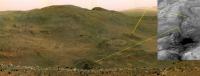
My other project for the night was to create a crude attempt to emphasize the apparent stratigraphy on McCool Hill. Has anyone noticed the possible outcrops across the valley?
I wish we had pancams to work with, but the navcams toward Home Plate on sol 581 and 582 are beginning to see some interesting details on the face of that hill. Perhaps a target for remote sensing after reaching Home Plate?...
Anyway, I took the navcam image, heavily unsharp-masked it to exaggerate the details, and then sketched in some lines where contiguous layers were 'apparent.' While some of these lines may not actually represent ledges, but instead the effects of downslope movement or craters seen obliquely, they are suggestive of east to west transport.

|
Posted by: SickNick Aug 24 2005, 05:52 AM
You are right.
This happens the same to me. There are plenty of sands on the top of mountain.
That is a strange thing. This deduces that the Martian sand can pose at much higher altitude than on the Earth due to the fact that the sand is very light along with strong wind and also with the force of dust devils along with the wind trappers by the special landforms and rocks.Rodolfo
Actually, all we learn from this is that it doesn't rain on Mars.
On Earth, mountaintops are the focus of rainfall (orographic rain, for the purists). Sand, dust and soil get washed off the top and can't be replaced except by rare wind transport of dry dust. Generally, the rain wins.
In winter, when there's powdery snow in abundance and no rain, then wind transport is dominant.
Hence, the dust on Mars resembles snowscapes on Earth. Different timescale, though. What happens in a season on Earth may take 1 million years on Mars!
- Nick Hoffman
Posted by: Tesheiner Aug 24 2005, 07:19 AM
Sol 581 navcam images looking west hit the ground just few hours ago.
Here is the view, including two additional DDs.
Edited: BTW, another drive was planned for today (sol 583). It should be already executed by this time.
Sol Seq.Ver ETH ESF EDN EFF ERP Tot Description
--- -------- --- --- --- --- --- ---- -----------
583 p1214.05 2 0 0 2 0 4 front_hazcam_ultimate_4_bpp
583 p1214.05 2 0 0 2 0 4 front_hazcam_ultimate_4_bpp
583 p1312.09 2 0 0 2 0 4 ultimate_rear_hazcam_2_bpp_pri15
|
|
Posted by: Tesheiner Aug 24 2005, 07:28 AM
... and the 360 deg view from the same sol with four DDs on sight.
|
|
Posted by: general Aug 24 2005, 07:52 AM
Nice article, Doug
http://www.spacedaily.com/news/mars-mers-05zzzp.html
(but "it's" should be "its" )
Posted by: djellison Aug 24 2005, 07:55 AM
http://www.spacedaily.com/news/mars-mers-05zzzp.html
(but "it's" should be "its"
)LOL - my English teacher of 12 years ago will be laughing very hard
I couldnt actually find it at the site though - how did you find it?
Doug
Posted by: general Aug 24 2005, 08:05 AM
I couldnt actually find it at the site though - how did you find it?
Doug
http://www.spacedaily.com/
Quite by accident, really: On the Spacedaily homepage, I clicked on "Russia Invites China's 1st Spaceman To Moon Flight", and on that page there's a link to your article (on the right hand side, under 'Spacedaily Express')
Posted by: djellison Aug 24 2005, 08:07 AM
Oh yeah - its there... '
Anyone else get banding on the large version of Tmans and Nix's mosaics?
Doug
Posted by: Tesheiner Aug 24 2005, 08:18 AM
Yes, me too.
Posted by: ustrax Aug 24 2005, 08:32 AM
Good article Doug, always a pleasure to read you.
Posted by: Tman Aug 24 2005, 08:42 AM
Thanks Doug, it's a nice summary of Spirit's trip. Right with (a bit) emotions.
Banding? Yes I too and by my pan they has become green
Posted by: dvandorn Aug 24 2005, 08:44 AM
Taken with the R0 Navcam on Sol 582.
A great view. Congratulations to the Rover Team.
jvandriel
Oh. My. God.
I'm grateful to be alive to see this view.
-the other Doug
Posted by: Nirgal Aug 24 2005, 09:19 AM
thanks for those phantastic 360er, Tesheiner & jvandriel !
http://mitglied.lycos.de/user73289/misc/spirit360_unstr.jpg
Alan, awsome panorama/color work !
Posted by: ustrax Aug 24 2005, 09:36 AM
Amazing pans from the south at exploratorium!
Posted by: Tesheiner Aug 24 2005, 09:50 AM
Homeplate as seen by pancam L2!
(L5 and L6 are available too)
Posted by: ustrax Aug 24 2005, 10:02 AM
hihihihihihohohohihihi!!!
I'm loosing my mind with all the things happening in such a short time!
Colore per piacere?
Posted by: djellison Aug 24 2005, 10:06 AM
I'd done a lovely partial pan - then a whole lot more came down 
http://www.unmannedspaceflight.com/doug_images/S_583_256_missing.jpg 750kb
The images are less than 8 hrs old.
Doug
Posted by: ustrax Aug 24 2005, 10:12 AM
I need to take a breath...This is too much information to assimilate in so short time...
Great, although partial, pan Doug!
Posted by: Nix Aug 24 2005, 10:15 AM
AWESOME! Been away for a couple of hours and..kaboom...sweet color frames coming down...
Let's get to work!
Thank you Doug, the article looks great!
Nico - getting emotional looking at Home Plate and surroudings in color...
Posted by: djellison Aug 24 2005, 10:15 AM
We need one of those brass plaques with an outline of the skyline - marking all the important features
Doug
Posted by: edstrick Aug 24 2005, 10:19 AM
6 frame color pan (bands 2,5,6)
No color correction except the left image
(bands 2 and 5, with a corner missing, adjusted to match)
Edge sharpened for details on the hills to the south.
********** DROOL! ***********
Gonna short out my keyboard at this rate....
|
|
Posted by: djellison Aug 24 2005, 10:29 AM
I've got it stitched in nasty-not-match-colour - and it's a stunner
Doug
Posted by: ilbasso Aug 24 2005, 10:33 AM
Seeing those views of Homeplate, I can't help thinking that we waited so long to get to the summit, now I can't wait for us to get on the road again to these exceptional new places. I'm sure the rover team must be falling all over themselves wrestling with the possibilities of what to do next!
Posted by: edstrick Aug 24 2005, 10:36 AM
Note that with long-base-line stereo images from the hilltop, we can SEE WHERE WE'RE GOING!.... rather than mostly guess, as we did on the climb. and going DOWNHILL will help extravagently.. just as long as we don'g to downhill "oops"...
thump.
bump!
Crunch!
TINKLE!
*** WAIL! ***
Posted by: paxdan Aug 24 2005, 10:42 AM
Image removed by paxdan
(L5 and L6 are available too)
Sorry to repost the whole image, doug can you resize it down please.
It looks to me like the top of that little knoll to the right of home plate is made of the same stuff as home plate itself. it looks like it might be the same layer. there is another fragment of similar looking material above and to the left of home plate. Perhaps it is a harder layer, any thoughts?
Posted by: djellison Aug 24 2005, 10:45 AM
Nope
One downside of invision is that you can make an image smaller. I may see if V2.1 allows it - as it would be nice to have them at 512 x 512 instead.
Doug
Posted by: edstrick Aug 24 2005, 10:47 AM
Paxdan commented: "It looks to me like the top of that little knoll to the right of home plate is made of the same stuff as home plate itself. it looks like it might be the same layer. there is another fragment of similar looking material above and to the left of home plate. Perhaps it is a harder layer, any thoughts?
The top of the knob to the right of homeplate is very red, while homeplate, especially near it's outer edge is bright, but decidedly not red. There are some very sharp outcrops to the 10:00 clock angle position <upper left> from homeplate. They're very red, too, but just to the left of them are some bright but less-red materials, rather like homeplate's color.
Posted by: Nirgal Aug 24 2005, 10:49 AM
No color correction except the left image
(bands 2 and 5, with a corner missing, adjusted to match)
Edge sharpened for details on the hills to the south.
********** DROOL! ***********
Gonna short out my keyboard at this rate....
phantastic, edstrick !
here is my attempt at a color re-calibrated version:

http://mitglied.lycos.de/user73289/misc/spirit_pan2.jpg
Posted by: Bill Harris Aug 24 2005, 10:54 AM
A simple L256 of a Pancam tricolor set of Homeplate, in glorious GeoColor.
Note that Homeplate is only one exposure of what has been termed the "Layered Unit" in the southern basin and the early interpretation of the "cindercone" is that it a simply a resistant caprock over a darker unit. Interesting weathering/erosion processes here.
Lovely area!
--Bill
PS-- it's a flood; there have been a half dozen new messages since I worked this message up...
Posted by: ustrax Aug 24 2005, 10:59 AM
Guys!!!
Stop that!!!
You are killing me with heavy delight and an overdose of amazement!!!
Posted by: edstrick Aug 24 2005, 11:03 AM
Nirgal said: here is my attempt at a color re-calibrated version.
Good tweek.. that looks reasonably close to "real" color.
I wish I had access to serious NASA/USGS image processing software (I probably actually do, but no time to deal with learning modern stuff)... I was once able to extract some pretty spectacular stuff out of Viking imagery with "principal components analysis". The color distribution is dominated by red/blue color variations, but there's much more in this data, though at much lower spectral contrast. Be a help to pick out different geologic units if I had it.
Posted by: Bob Shaw Aug 24 2005, 11:08 AM
Hopefully some of the flood of data can be turned into super-res imagery of Home Plate and environs... ...it certainly looks like cap rock to me (at present!).
Posted by: djellison Aug 24 2005, 11:27 AM
I have images of Alan, Nico and I 'virtually' racing one another to make this one 
http://www.unmannedspaceflight.com/doug_images/S583_homeplate.jpg 2Mbytes
Doug
Posted by: ustrax Aug 24 2005, 11:51 AM
Looking at the latest pancam images I could see one thing, the terrain closer to Ultreya is really getting darker and darker, and then I look closer and...
Is it a rock on the hill?
Or...Is it the first glimpse of Ultreya?...
http://i16.photobucket.com/albums/b14/ustrax3/ultreyasight.jpg
(Color image by Nirgal)
Posted by: Tman Aug 24 2005, 11:55 AM
What a great time!!! I'm wandering around in a "realtime" Mars exhibition...
Can you imagine there sit some of the MER team in their room and behind runs a computer with Unmanned Spaceflight.com, then suddenly someone call "hey a next image coming in" after that the answer "copy that, take it on the left screen"...
Doug, thats a beauty again!
Posted by: Decepticon Aug 24 2005, 12:16 PM
I would love to see a Photoshop of a ocean on the lower plains to get a feel for what this area looked like millions of years ago.
Posted by: Reckless Aug 24 2005, 12:25 PM
Aaargh it's all happening too fast and i've got to go to work before I can look at all this new stuff and The book just arrived in the post!
Read you later
Roy F
Posted by: Tesheiner Aug 24 2005, 12:37 PM
What a beautiful day!
Absolutely stunning panoramas.
Posted by: paxdan Aug 24 2005, 12:41 PM
Its increadible to be part of exploration and discovery via this board. thanks you guys.
Posted by: ustrax Aug 24 2005, 12:51 PM
I'm wandering around in a "realtime" Mars exhibition...Can you imagine there sit some of the MER team in their room and behind runs a computer with Unmanned Spaceflight.com, then suddenly someone call "hey a next image coming in" after that the answer "copy that, take it on the left screen"...
Doug, thats a beauty again!
Do you really believe they're following this?...
Let me just brush my hair and put some parfum...
Posted by: TheChemist Aug 24 2005, 01:12 PM
A BIG BIG thank you guys for the work you put in creating all these beautifull panoramas.
Ustrax, I 'd like to agree with you, but it seems to me it is just a rock on the horizon.
BTW, where is Summit #1 ? It is gone from the last JPL map, and I don't seem to find it in the panoramas. Have we already went past it, or was its hight overestimated ?
Posted by: ustrax Aug 24 2005, 01:17 PM
Ustrax, I 'd like to agree with you, but it seems to me it is just a rock on the horizon.
BTW, where is Summit #1 ? It is gone from the last JPL map, and I don't seem to find it in the panoramas. Have we already went past it, or was its hight overestimated ?
Yes, probably a rock, but a little drive ahead, let's say...10 to 20 mts should provide us the view into it.
About summit #01 I believe that in the latest panoramas is on the left side but behind Spirit.
Posted by: Bill Harris Aug 24 2005, 01:20 PM
...Is it the first glimpse of Ultreya?...
Might be. Here is a 5x exaggeration of a portion of Nirgal's image and the topography is certainly correct. I think I can see a ledge of the Homeplate Unit in the lower left corner as the terrain goes lower...
We'll know more in a few days.
Stay tuned, same time, same channel... will Ustrax survive?
--Bill
Posted by: Phil Stooke Aug 24 2005, 01:25 PM
Incredible stuff. This is the first time I have felt that the panoramas from Apollo 15 or 17 have been outdone. In terms of sheer stunning beauty, that is... lots of Mars scenes have had more intrinsic geological interest, I think, because there is so much more going on. But for that breathtaking "standing on the edge of the Grand Canyon" type of awe, the best Apollo pans still were the best. But not any more.
Phil
Posted by: ustrax Aug 24 2005, 01:26 PM
We'll know more in a few days.
Stay tuned, same time, same channel... will Ustrax survive?
--Bill
Might?!!
Might! Might! Might!
Water please!...
Proud to be part of the martian's favourite reality show...
Oh God...I'm happy...
Posted by: Nix Aug 24 2005, 01:52 PM
I'm glad for you Ustrax!
I'll second that Phil..it's an awesome vista. Incredible.
Nico
Posted by: ustrax Aug 24 2005, 01:52 PM
One more stretch and...
http://i16.photobucket.com/albums/b14/ustrax3/ultreyasight2.jpg
Posted by: Harder Aug 24 2005, 02:23 PM
I would like to add my thanks to all the contributors to this rollercoaster ride of new vista's. Absolutely fantastic! Anyone "related" to the Smithsonian Air & Space Museum in Washington? I get the feeling its high time to place a full-size rover there, next to the other great space achievements, but this time around with a big plasma screen on the wall with the latest views from Unmanned Spaceflight.com at yr fingertips! That would truly reward the contributors to this board!!
Posted by: TheChemist Aug 24 2005, 02:40 PM
Double post deleted.

|
Posted by: TheChemist Aug 24 2005, 02:43 PM
I think we just miss Ultreya at the moment. Here is what I think we see :
The colour image is 2x vertically enhanced crop from Doug's color panorama of homeplate posted above. The BW is a crop from http://marsrovers.jpl.nasa.gov/gallery/press/spirit/20040602a/08-JR-08-crater-A147R1.jpg
Posted by: ustrax Aug 24 2005, 02:43 PM
The colour image is 2x vertically enhanced crop from Doug's color panorama of homeplate posted above. The BW is a crop from http://marsrovers.jpl.nasa.gov/gallery/press/spirit/20040602a/08-JR-08-crater-A147R1.jpg
It is just me or the image doesn't show up?...
Posted by: um3k Aug 24 2005, 02:46 PM
I get a red X.
Posted by: TheChemist Aug 24 2005, 02:46 PM
A double post with an attachment is a nightmare to clean up, wait a sec please
Edit: ok, it should be visible here, I hope
|
Posted by: ustrax Aug 24 2005, 02:47 PM
Guess the problem is solved...
Yes The Chemist, that is my approach on it, what I was trying to say is that we're at a few meters drive of seing that southernmost edge of Ultreya right in front of the nearest elevation.
Posted by: David Aug 24 2005, 02:48 PM
Thanks to everyone who's been doing the great work to put together these stunning panoramic images -- and thanks also to JPL, and especially to Spirit.
I have to say that, looking at these images is the first time that I felt that Mars was actually a real place, rather than just a map (seen from orbit) or a sandbox with a few rocks in it. Here you get a sense of Mars as a planet, a real world with vistas stretching out to really distant horizons, but from a point of view that is part of it, rather than a head-hanging-down-from-the-sky point of view. It looks like it could be part of earth; but then you notice the strange geology, and you're reminded that you could walk for a thousand years and never reach a place like this. Then you start feeling chills. What's most marvelous is that it's entirely new. I've read a lot of science fiction about Mars over the years, and some of the descriptions have been better and some worse, but none of them gave me a vista from a mountain top looking out at the dust-devils sweeping over the plains. That all by itself is worth a million dollars.
Posted by: general Aug 24 2005, 02:49 PM
The link works just fine for me
Here it is in full:
http://marsrovers.jpl.nasa.gov/gallery/press/spirit/20040602a/08-JR-08-crater-A147R1.jpg
Edit: Too late...
(things go too fast for me, here )
Posted by: ustrax Aug 24 2005, 02:54 PM
Here it is in full:
http://marsrovers.jpl.nasa.gov/gallery/press/spirit/20040602a/08-JR-08-crater-A147R1.jpg
Edit: Too late...
(things go too fast for me, here )They are *really* fast today, looks like there was a cleaning event here...
Posted by: Tesheiner Aug 24 2005, 02:58 PM
Ustrax,
And you thought that by leaving on vacations on August you would have lost all of this...
Posted by: Gonzz Aug 24 2005, 03:08 PM
'Lurker mode off'
Oh guys, those are really amazing images, It's through your work that I'm following this amazing journey on planet Mars. You really make the difference. With the rover team busy controlling the rover (rightly so), and with the corresponding decrease of processed images comming from the NASA site you have stepped in and took the job of helping us all live through this wonderfull experience by showing us Mars in all it's full glory.
I don't contribute much to the forums, I don't come from a scientific background so I don't usually get involved in the geo discussions (although I love to read them), and my job keeps me so busy I hardly get the time to read through the tech imagery threads (so I could learn how to produce this beautiful images), nevertheless I come here everyday and everyday I am amazed by what I find here.
On behalf of all us lurkers a very big thank you, merci, obrigado, danke, grazie, gracias, dank u!
You bring joy and amazement to a lot of people!
'lurker mode on' 
Posted by: djellison Aug 24 2005, 03:11 PM
I have a special lurkdar - a lurker detection machine - and it's off the scale
Yesterday - we had 116450 hits, instead of the more usual 50,000 or so
That translates into 1500 visits instead of the usual 800ish.
Doug
Posted by: ljk4-1 Aug 24 2005, 03:12 PM
From the Cornell Daily Sun:
* Mars Rovers Make Progress
Despite seemingly hopeless long treks, and an encounter with a
dangerous sand dune, the Mars rovers made major advances and found
evidence of water in new regions of the planet this summer.
The Spirit rover reached the summit of Husband Hill...
http://www.cornellsun.com/vnews/display.v/ART/2005/08/24/430bf1e61df0d
Posted by: Astrophil Aug 24 2005, 03:21 PM
Amazing pictures.
Anyone got any thoughts on the trapezium-ish-shaped darker area within the pale material within Homeplate? Is that going to turn out to be sand or dust, or what, making that colour change?
Posted by: RGClark Aug 24 2005, 03:29 PM
Great images Chemist, Doug and Nirgal.
Those two cones near "home plate" do look like cinder cones. Perhaps these will prove to be recent volcanic activity.
The flat area called "home plate" looks to me like a "maar", a volcanic crater due to water, volcanic interaction.
Some mounds on this side of the Columbia Hills were interpreted by Carbol et.al. as frost mounds:
Thyra Crater.
http://cmex.arc.nasa.gov/CMEX/data/catalog/GusevCrater/ThyraCrater.html
However, another interpretation is that they are lava flows:
A volcanic interpretation of Gusev Crater surface materials
from thermophysical, spectral, and morphological evidence.
JOURNAL OF GEOPHYSICAL RESEARCH, VOL. 110, E01003, doi:10.1029/2004JE002327, 2005
http://www.geo.umass.edu/courses/geo892/Feb_16_paper_don.pdf
See p. 18 and Fig. 17.
Bob Clark
Posted by: ustrax Aug 24 2005, 03:35 PM
Those two cones near "home plate" do look like cinder cones. Perhaps these will prove to be recent volcanic activity.
The flat area called "home plate" looks to me like a "maar", a volcanic crater due to water, volcanic interaction.
Some mounds on this side of the Columbia Hills were interpreted by Carbol et.al. as frost mounds:
Thyra Crater.
http://cmex.arc.nasa.gov/CMEX/data/catalog/GusevCrater/ThyraCrater.html
However, another interpretation is that they are lava flows:
A volcanic interpretation of Gusev Crater surface materials
from thermophysical, spectral, and morphological evidence.
JOURNAL OF GEOPHYSICAL RESEARCH, VOL. 110, E01003, doi:10.1029/2004JE002327, 2005
http://www.geo.umass.edu/courses/geo892/Feb_16_paper_don.pdf
See p. 18 and Fig. 17.
Bob Clark
RGClark, I went looking for the maar features you've talked about, and it looks like a consistent hypothesis for me...
http://volcano.und.nodak.edu/vwdocs/volc_images/north_america/Maar_xsect.jpg
Here is an earthly example:
http://home.planet.nl/~monique.schilders/maar.jpg
Posted by: ustrax Aug 24 2005, 03:37 PM
And you thought that by leaving on vacations on August you would have lost all of this...
I was charging batteries under the unclement iberian sun...
Posted by: RedSky Aug 24 2005, 03:42 PM
David... you expressed my sentiments exactly. Some of the initial black & white navcams from the summit... with windswept dunes and textured, weathered rock, and vistas of Tennessee Valley, and the plains beyond... are really artistic in the same league as an Ansel Adams photo of Yosemite in the western U.S. And the dust devils just make it seem that much more "alive". Then the color pancams... wow. You just get the feeling that you're able to stand there and witness this place.. I just have to add my thanks to all on this forum who work so feverishly to bring such incredible vistas to life..... and to the MER team for providing all this raw info to work with!
Posted by: Bill Harris Aug 24 2005, 04:10 PM
Might! Might! Might!
Water please!...
Proud to be part of the martian's favourite reality show...
Oh God...I'm happy...
Now watch Spirit find a neat outcrop and spend the next 30Sols scratching-and-sniffing. And Ustrax will have conniption fit of Arean proportions...
--Bill
Posted by: ustrax Aug 24 2005, 04:18 PM
--Bill
I had to go and check the meaning of 'conniption fit'...
Who made till here will resist...I guess...

But I would be verrry verrry pleased if the MER team, decided to make a little tiny minimum drive to south, that would be sufficient to wave to Ultreya...
Dames et Chevaliers back there?...10mts and back?...Prrlease?...
Posted by: Bill Harris Aug 24 2005, 05:04 PM
I believe that she will spend a few Sols doing an ultra-panorama of the vicinity and then we will make our way south to the Inner Basin. There is some exemplary geology to be seen there.
Posted by: algorimancer Aug 24 2005, 05:22 PM
You know, a panoramic view like this from some peak on the Moon would have done heck of a lot of good for public interest in lunar exploration...
Posted by: SigurRosFan Aug 24 2005, 05:26 PM
That's my (first) contribution.
It's a pair of the Tmans great b/w pano and a colored rover seen from Sol 581 at the Sol 582 position. Is the rover size okay?
http://xs43.xs.to/pics/05343/Sol_582_Spirit_seen_from_Sol_581.jpg (1.2 MB)
-- blue_scape
Posted by: aldo12xu Aug 24 2005, 05:36 PM
What an amazing way to start the day!! Doug, Edstrick, Nirgal, Tman, NIX, jvandriel, Teshnier, Alan, etc., you guys have done an incredible job!! This is the second most important event in space exploration (next to the first lunar landing) and thanks to you guys we're watching here virtually live as it happens. Makes me feel like a kid all over again!
Posted by: Tman Aug 24 2005, 06:27 PM
Nico (the other), nice idea! Are you able to get the Rover in b/w? Because it would looks more realistic I guess. If not, I could it send to you...
Regarding the size of the Rover, I dont know, maybe a bit larger? I guess Dilo could it know..., Dilo?
@Aldo, thank you too! What a MER week that let rise men's heartbeat so high
Posted by: paxdan Aug 24 2005, 06:28 PM
Regarding the size of the Rover, I dont know, maybe a bit larger? I guess Dilo could it know..., Dilo?
yeah and shouldn't it be facing the other way?
Posted by: SigurRosFan Aug 24 2005, 06:29 PM
Okay. I wait.
Posted by: SigurRosFan Aug 24 2005, 06:32 PM
My mistake. You're right.
-- blue_scape
Posted by: SigurRosFan Aug 24 2005, 06:45 PM
And could you rotate the rover, Tman?
Posted by: SigurRosFan Aug 24 2005, 07:18 PM
It's done.
http://xs43.xs.to/pics/05343/Spirit_Sol_582_Rover.jpg (1.2 MB)
Posted by: djellison Aug 24 2005, 08:51 PM
http://www.nasa.gov/multimedia/nasatv/MM_NTV_Breaking.html
Sept 1st.
Doug
Posted by: jamescanvin Aug 25 2005, 01:11 AM
Wow! What a way to start the day! What a thread, thanks for all the pans guys, unbelevable stuff.
James
Posted by: Pando Aug 25 2005, 05:16 AM
djellison: "Sept 1st."
...shall be the day they unveil the MOAP
Actually, I'm glad to be back as well, just in time, and finding this place teeming with life, joy, excitement, and amazement! Wow, what can I say... what a great community this is!
And of course the images coming down in the past few hours have been nothing short of breathtaking. A big congrats to the MER team for this incredible milestone! Spirit is the king of the hill!
Also, isn't it wonderful that we all have the opportunity to work with near-live images as they come down? It definately keeps our spirit up
Posted by: CosmicRocker Aug 25 2005, 05:19 AM
I totally agree. The recent pancams and the resultant color panoramas knocked my socks off. Home Plate is surrounded by several flat-topped mesas of similar elevation, suggesting that this area was once covered by layered rocks that have been mostly eroded away. I really don't see cinder cones, but instead eroded remnants, where a few mesas are left, protected by patches of caprock. Home Plate is still a bit of a geomorphic curiosity, but it now seems to be clearly a "plate" elevated above its surroundings...like an erosional remnant.
The opposite side of the valley contains spectacular layered outrops that I look forward to seeing close-up, or at least from Home Plate. And then, what about that jumbled-up mess off to the right?
Is this exciting stuff, or what?
Posted by: GADean Aug 25 2005, 05:38 AM
A "remnant layer" was my first reaction as well. It's tough to tell with just the one viewpoint, but my eyes see an eroded syncline. The layer that makes up the Home Plate feature also appears on the top of the "mesas", as Cosmic Rocker points out, and perhaps angling up the side of the hillside to the left of HomePlate.
That much erosion and removal of material is easy on Earth, but I don't know about Mars. We might need to assume that the gross features of the terrain were created by impacts, and that volcanic ash and flow might have layed over it and modified it.
BTW: Thanks and kudos for the fast and spectacular panoramas. I'ved used some of these software tools for Earth-bound panoramas and I know how tricky it can be to get good results. You fellas are getting very good at this!
Posted by: glennwsmith Aug 25 2005, 06:22 AM
It is my impression that Spirit took a SHORT drive between the first spectacular photos of "the other side of the mountain" and those of today with Home Plate front and center. I guess this is a function of being right near the top -- a slight change in position can reveal totally new vistas. . .
and soon we will be staring into an abyss! And Mr Chemist -- that was a superb job of correlating the two views of Home Plate -- I think the X2 vertical exaggeration is optimal . . .
Posted by: Tesheiner Aug 25 2005, 06:46 AM
A really short drive.
http://nasa.exploratorium.edu/mars/spirit/rear_hazcam/2005-08-23/2R178037067EFFAE00P1312L0M1.JPG
http://nasa.exploratorium.edu/mars/spirit/rear_hazcam/2005-08-24/2R178118500EFFAE03P1312L0M1.JPG
IMHO, this adjustment was a "fine-tune" for better UHF passes.
Posted by: Rxke Aug 25 2005, 08:14 AM
BoyohboyohboyohBOY!
Great stuff, everybody!!
Just before Sol 581 I reached my bandwidth limit for the month, I can assure you, that's baaaaaaad for the heart!
(My own fault, running MMR downloading older Sols when I know I'm already close to my 10gig/month limit...)
So now all this heady stuff comes trickling in... Slooooowly but surely, heehee!
What....a....view!
*sits back and smiles*
Thanks guys!
Posted by: jvandriel Aug 25 2005, 08:24 AM
Here is the black and white panoramic view of Tennessee Valley.
Taken with the L6 Pancam on Sol 582.
jvandriel

|
Posted by: Tesheiner Aug 25 2005, 09:02 AM
Whooohooo!!!
Today there is a panorama party too!
As part of the MOAP, here is my version of the view looking south (taken on Sol 583).
It's B&W (L2 filter); color handling is just for the masters.

|
Posted by: Tesheiner Aug 25 2005, 09:05 AM
And from the fresh images that hit the ground just 1-2 hours ago, part of the MOAP section looking north taken on sol 584.

|
Posted by: MichaelT Aug 25 2005, 09:42 AM
And another panorama, generated from 256L pancam images (Sol 584), showing the beautifully sand(dust)blasted rocks.
http://www.muk.uni-hannover.de/~theusner/mars/PANO_2PC_SOL584_02.jpg
http://www.muk.uni-hannover.de/~theusner/mars/PANO_2PC_SOL584_03.jpg
Michael
Posted by: Decepticon Aug 25 2005, 11:45 AM
Looks like the wind might help the panels a bit Up here.
Posted by: Tman Aug 25 2005, 02:32 PM
Nice pan Michael! After we saw mostly hard ground here on the southwest side of Husband Hill, comparing to the deeper sandy ground in Tennessee Valley over Methuselah, I guess the main wind direction comes or came roughly from south to north.
Posted by: RNeuhaus Aug 25 2005, 03:41 PM
http://marsrovers.jpl.nasa.gov/gallery/press/spirit/20040602a/08-JR-08-crater-A147R1.jpg
Edit: Too late... (things go too fast for me, here )
After studying the route to Home Plate: On the East side is most challenging than the west side. Hovewer, I seems that on East side has more geological interest than the other and by that route would take longer time to reach at the bottom close to Ultreya before going to sleep forever on Home Plate. Off road speaking, both ways are possible.
Rodolfo
Posted by: ustrax Aug 25 2005, 03:56 PM
Edit: Too late...
(things go too fast for me, here )After studying the route to Home Plate: On the East side is most challenging than the west side. Hovewer, I seems that on East side has more geological interest than the other and by that route would take longer time to reach at the bottom close to Ultreya before going to sleep forever on Home Plate. Off road speaking, both ways are possible.
Rodolfo
This route, traced by Andy G,
http://personal.strath.ac.uk/cjis28/route.jpg
gives another perspective to the one I've come up with on the 'On The Way To Home Plate ' thread and goes along with the radical hikers in the house...
Posted by: ustrax Aug 25 2005, 03:58 PM
http://personal.strath.ac.uk/cjis28/route.jpg
gives another perspective to the one I've come up with on the 'On The Way To Home Plate ' thread and goes along with the radical hikers in the house...
The only difference is that on my approach Spirit goes along Ultreya and reaches Home Plate by it's west side.
Posted by: jvandriel Aug 25 2005, 04:13 PM
A look at Homeplate from Husband Hill.
Taken with the L 2 Pancam on Sol 582.
jvandriel

|
Posted by: RNeuhaus Aug 25 2005, 07:00 PM
http://personal.strath.ac.uk/cjis28/route.jpg
gives another perspective to the one I've come up with on the 'On The Way To Home Plate ' thread and goes along with the radical hikers in the house...
I like that route. However, I don't know what are the slopes along that way. If the slope is greater than 20 degree, then it is time to be beware. Thru it is possible if the land is of sand land which are the best friends to go down. They help to drag better on downhill than on rocky land which is more slippery specialy if there are many small stones.
Rodolfo
Posted by: dilo Aug 25 2005, 08:13 PM
...
May be useful to see it in 3D
: anaglyph

|
parallel eyes:

|
crossed eyes (my preferred):

|
Posted by: aldo12xu Aug 25 2005, 08:38 PM
Wow, Dilo! That is so cool!! And thanks for posting a parallel stereo version. Any chance of posting the individual left and right frames at higher resolution so I can put them StereoPhotoMaker and play with them? We might be able to trace individual layers from hill to hill using your stereo pairs.
What a week!!!
Posted by: Tman Aug 25 2005, 08:52 PM
Hui Dilo, Columbia Hills in 3D
I guess it looks rather too steep to reach Home Plate in this way
Posted by: Nix Aug 25 2005, 09:19 PM
That's what I thought Tman...
http://www.awalkonmars.com/A1583PCM8L256E1waydown.jpg
This looks safer to me.
http://www.markcarey.com/mars/discuss-28218-on-the-way-to-home-plate.html
Nice work dilo, you're a busy man too these days
Nico
Posted by: Sunspot Aug 25 2005, 09:24 PM
The wind has removed the finer dust from many areas leaving larger grains piled up in dunes... anyone think these look a little like "blueberries" ?
http://qt.exploratorium.edu/mars/spirit/pancam/2005-08-25/2P178213298EFFAE03P2266L6M1.JPG
They do look vaguely spherical - at least in this pancam image - the MI would be needed to get a good look.
Posted by: dilo Aug 25 2005, 10:59 PM
Tman, In order to appreciate slopes, is better an enhanced vertical scale (x2) with also color-coded height:
left:

|

|
Aldo, here two separated b/n:
left:

|

|
These two views from other angulations!

|
Posted by: Nix Aug 25 2005, 11:20 PM
While there sure is enough to see and understand in the hills itself from this vantage point, staring at this 1x3 mosaic;
http://www.awalkonmars.com/A1583PCM8L256Eg1.jpg
I noticed that the boundary between geological units designated AHbm1 & AHgf1 (http://pubs.usgs.gov/imap/i2666/) is visible.
Columbia Hills along with the mesas are interpreted to be part of the AHbm1 unit which also covers a large area south of Thira (to the right of Thira in the mosaic).
In between is the basin floor unit AHgf1, which together with AHgf2 comprises the largest area of Gusev Crater; the plain on which Spirit landed.
In the mosaic the boundary between these units is clearly visible, rough terrain up there! The western side of the lobes in front of remaining AHbm1 material makes up most of what we see of the boundary in the image. I hope more images are coming down soon...
See also my selected orbital views http://www.awalkonmars.com/Spirit%20Location.htm.asp for some context-views.
Nico
Posted by: Nix Aug 25 2005, 11:37 PM
This http://qt.exploratorium.edu/mars/spirit/pancam/2005-08-24/2P178124057EFFAE03P2261L6M1.JPG belongs to the right~south in the mosaic and shows the extending of the boundary southward.
The L5(green filter) image is still missing data at this time.
Nico
Posted by: Tesheiner Aug 26 2005, 06:48 AM
Taken with the L 2 Pancam on Sol 582.
jvandriel
Maybe on sol 583?
See:
Sol Seq.Ver ETH ESF EDN EFF ERP Tot Description
--- -------- --- --- --- --- --- ---- -----------
582 p2299.03 54 0 0 54 1 109 pancam_tennessee_valley_6cx3r_L456
583 p2260.04 30 0 0 30 0 60 pancam_summit_pan_2cx3r_L256R27
583 p2261.04 60 0 0 60 0 120 pancam_summit_pan_4cx3r_L256R27
583 p2262.04 45 0 0 45 0 90 pancam_summit_pan_3cx3r_L256R27
Edited: BTW, did you try to include the lower row in the panorama? See this http://www.unmannedspaceflight.com/index.php?showtopic=1071&view=findpost&p=18254.
Posted by: CosmicRocker Aug 26 2005, 07:51 AM
...glad to see there's another that thinks so...
Posted by: Nix Aug 26 2005, 08:46 AM
Oh but you're not alone, I share the hypothesis.
The plain Spirit landed on seems to be slightly more elevated than the Basin -and-just maybe an impact that created the Hills and/or impacts that struck the hills uplifted an earlier unit while wind/water erosion took care of the rest-leaving a few 'islands' like Home Plate. Maybemaybemaybe...wild speculation of course..
Nico
Posted by: djellison Aug 26 2005, 08:50 AM
Sounds reasonable - if you consider the basaltic floor of gusev hiding all the 'good stuff' under metres of basalts - then an impact or volcanic event would bring it back to the surface or offer a window into it. The basic does look very diferent to everything else around.
Posted by: Tesheiner Aug 26 2005, 09:12 AM
FYI,
Today (sol 585) pancam images are already "on the ground".
Posted by: djellison Aug 26 2005, 09:21 AM
Today (sol 585) pancam images are already "on the ground".
I've never seen them downlink a full res panorama so quickly. The mission success pan from Opportunity only took 2 days to take - but it was less than half as large data wise than this - and this is coming down in massive 100 Mbit chunks
They must be getting excellent UHF coverage being sat on a hill Doug
Posted by: AndyG Aug 26 2005, 09:43 AM
Rodolfo
Hi Rodolfo,
I like that route too.
But is there any evidence of slopes as steep as that?
I see that the MER traverse limits are 30 degrees, so there'd be possibilities to "hairpin" down even steeper slopes, especially since Spirit won't need to go back up them again. Meanwhile the maximum limit is 45 degrees (shudder!)
The question must be: is there an advantage of staying on the ridgeline for as long as possible, instead of coming off it early? An "early off" maximises the finding of exposed layers and gets Spirit into new areas (Ultreya, Homeplate) faster. Staying on the ridgeline does little more than maintain Spirit in dust-cleaning winds and producing pretty panoramas. ;-)
Andy G
Posted by: ustrax Aug 26 2005, 09:47 AM
http://www.awalkonmars.com/A1583PCM8L256Eg1.jpg
I noticed that the boundary between geological units designated AHbm1 & AHgf1 (http://pubs.usgs.gov/imap/i2666/) is visible.
Columbia Hills along with the mesas are interpreted to be part of the AHbm1 unit which also covers a large area south of Thira (to the right of Thira in the mosaic).
In between is the basin floor unit AHgf1, which together with AHgf2 comprises the largest area of Gusev Crater; the plain on which Spirit landed.
In the mosaic the boundary between these units is clearly visible, rough terrain up there! The western side of the lobes in front of remaining AHbm1 material makes up most of what we see of the boundary in the image. I hope more images are coming down soon...
See also my selected orbital views http://www.awalkonmars.com/Spirit%20Location.htm.asp for some context-views.
Nico
Hey NIX, what are you trying to provoke here? A collective delirium with your images?!
Marvelous, just marvelous...
About the route...Looking at NIX's panorama, it seems like it is a quite pleasant journey down there.
Posted by: Tesheiner Aug 26 2005, 11:25 AM
With the last images downloaded today (sol 585) there are enough "shots" to do this:
|
|
This is a partial "Mother of all panoramas" (B&W) covering some 300 degrees (looking north, west, south, and partially east) and it's about 80% of the whole 360º panorama (the view looking to the summit is still missing).
Note that this one is made of 23 frames and contains only the topmost row of the MOAP, the one looking to the horizon.
The full panorama will be huge!
Posted by: ustrax Aug 26 2005, 11:34 AM
|
|
This is a partial "Mother of all panoramas" (B&W) covering some 300 degrees (looking north, west, south, and partially east) and it's about 80% of the whole 360º panorama (the view looking to the summit is still missing).
Note that this one is made of 23 frames and contains only the topmost row of the MOAP, the one looking to the horizon.
The full panorama will be huge!
...
Posted by: Nix Aug 26 2005, 12:23 PM
...
...
...
...
...
...
Posted by: Rxke Aug 26 2005, 12:34 PM
Steve wasn't exaggerating when he said this was going to be the mother of all pans!
Posted by: paxdan Aug 26 2005, 12:45 PM
i think i'll start looking now for a printer who can do me a wall size banner of the MOAP....
Posted by: ustrax Aug 26 2005, 12:59 PM
Well paxdan...I've got that problem solved...Look what I've got at work:
http://www.topsupply.com.br/produtos/equipamentos/Mimaki-JV3-160S.jpg
Posted by: gpurcell Aug 26 2005, 01:03 PM
|
|
This is a partial "Mother of all panoramas" (B&W) covering some 300 degrees (looking north, west, south, and partially east) and it's about 80% of the whole 360º panorama (the view looking to the summit is still missing).
Note that this one is made of 23 frames and contains only the topmost row of the MOAP, the one looking to the horizon.
The full panorama will be huge!
Pitcher's mound is looking a lot less like a cinder cone and a lot more like a mesa....
Posted by: ustrax Aug 26 2005, 01:51 PM
They must be getting excellent UHF coverage being sat on a hill Doug
More images uploaded...
Posted by: RGClark Aug 26 2005, 02:30 PM
Those two cones near "home plate" do look like cinder cones. Perhaps these will prove to be recent volcanic activity.
The flat area called "home plate" looks to me like a "maar", a volcanic crater due to water, volcanic interaction.
Some mounds on this side of the Columbia Hills were interpreted by Carbol et.al. as frost mounds:
Thyra Crater.
http://cmex.arc.nasa.gov/CMEX/data/catalog/GusevCrater/ThyraCrater.html
However, another interpretation is that they are lava flows:
A volcanic interpretation of Gusev Crater surface materials
from thermophysical, spectral, and morphological evidence.
JOURNAL OF GEOPHYSICAL RESEARCH, VOL. 110, E01003, doi:10.1029/2004JE002327, 2005
http://www.geo.umass.edu/courses/geo892/Feb_16_paper_don.pdf
See p. 18 and Fig. 17.
Bob Clark
According to this glossary cinder cones don't involve interaction with water:
Volcanic and Geologic Terms.
http://volcano.und.nodak.edu/vwdocs/glossary.html
If the flat area is indeed a maar then perhaps the nearby cones are tuff cones which like maars are created through volcanic water interaction:
HYDROVOLCANIC ERUPTIONS
http://www.geology.sdsu.edu/how_volcanoes_work/Hydrovolcanic.html
Tuff Cone - Maar Volcano.
http://geology.about.com/library/bl/images/bltuffcone.htm
Bob Clark
Posted by: aldo12xu Aug 26 2005, 02:55 PM
Thanks for that link, Bob. This does look sorta familiar, no?
http://www.geology.sdsu.edu/how_volcanoes_work/Thumblinks/tuffring_page.html
....except that it's felsic volcanics and not basaltic. But I seem to have read somewhere that basaltic glass is common to tuff cones.
Posted by: GADean Aug 26 2005, 04:42 PM
Columbia Hills along with the mesas are interpreted to be part of the AHbm1 unit which also covers a large area south of Thira (to the right of Thira in the mosaic).
In the mosaic the boundary between these units is clearly visible, rough terrain up there! The western side of the lobes in front of remaining AHbm1 material makes up most of what we see of the boundary in the image. I hope more images are coming down soon...
Nico
Thanks for placing a smaller reproduction of the map on your site, Nico. Much better than waiting for the 70+meg download! Having done some geological mapping as a student, I can't imagine such detailed mapping from orbit.
I wonder if what we are seeing in your spectacular mosaic is not the edge of "dust-devil alley", the anomalous, dark area "scrubbed" by dust-devils that surrounds the Columbia Hills. The lighter colored surface seems to extend to the north in front of the Thera rim. The change in surface coloration is quite dramatic in the Mars Express color photos, so I would expect that we would be able to see it in Mer photography as well.
Posted by: aldo12xu Aug 26 2005, 06:58 PM
Thanks, Dilo! I can't wait to get home and look at them in more detail.
Posted by: Nix Aug 26 2005, 08:41 PM
Interesting links RGClark. GADean, the southeastern boundary of the eastern 'lobe' of dust-devil formation -at this time- (the regions of formation change slightly over time, see Viking imagery) extends to the boundary of the geological units.
The areas of dust-devil formation -again at this time- seem to avoid the central part of Gusev Crater, the major part of unit AHgf2. I've wondered before how the mesas and winds coming down from Ma'adim Vallis or the northern low elevations of the rim might play a role in this.
I'd be interested if someone knows of some good reading on the subject of wind directions in and around Gusev Crater, and the role they play in the formation of DD's along with seasonal temperature variations..
I guess the observations of sunlight hitting different slopes in the area as they announced to be investigating from this 'mountaintop-observatory' will provide valuable new data on this.
Say, if you'd like more compressed .jpeg crops and lower-res versions of these maps just mail me, I have a bunch of them I made of the original -large- files.
Nico
Posted by: Nirgal Aug 27 2005, 01:51 AM
ok, just to shorten the time until the "big" color panorama arrives:
here is another synthetic colorization (from the sol 581 "thyra" single band L7-pancam)
http://mitglied.lycos.de/user73289/misc/spirit_p581_col.jpg
Posted by: GregM Aug 27 2005, 04:41 AM
.
Posted by: mike Aug 27 2005, 05:05 AM
Usually I would bemoan anyone taking artistic liberty with 'raw scientific data' (hey, it's straight from NASA, not from some 'average' guy's camera..), but when the results are as cool as that, Nirgal, I just can't. And really, when everyone and their brother is up on Mars using Photoshop (Brain Implant Edition) to do whatever they want, you'll simply be a visionary. As long as people know that that's not the rawest of the raw data (however you would define that, I don't know..), kudos.
Posted by: Nirgal Aug 28 2005, 06:11 PM
Thanks, Mike ... you make a good point: it's always hard to find the balance between scientific accurateness and visual "pleasantness" of an image ... And yes, as most of the process of human vision takes places not only in the retina but even more so in the post-processing of the visual cortex, the actual appearance of a scene is a highly subjective experience of the observer .. so in a certain sense, everyone of us already carries his own version of your "Brain-Implant Photoshop editions"
Posted by: djellison Aug 28 2005, 11:06 PM
I've had another hack at it...
http://www.unmannedspaceflight.com/doug_images/HusbandSouthEast.jpg 2.3 Mb
Lots of visible seams, but I've given up trying to make them go away
Doug
Posted by: Gonzz Aug 29 2005, 04:29 AM
"Seams" alright
Posted by: Nix Aug 29 2005, 08:07 AM
a 13x3 beauty Doug.. Nice colors!
Nico
Posted by: vikingmars Aug 29 2005, 08:17 AM
GREEEAT job Doug !
Here is the top-row 360° seamless pan with coordinates done this W-E.
Enjoy !

|
Posted by: Tesheiner Aug 29 2005, 08:51 AM
Wonderful view, vikingmars!
If you are planning to make the whole 27x3 pano, please post it.
Posted by: djellison Aug 29 2005, 08:58 AM
Nice view Ol It shows better than anything else that we're actually on top of a hill
Doug
Posted by: vikingmars Aug 29 2005, 10:33 AM
Here is also the sol 582 seamless mosaic as a wallpaper to download (1280x1024)
Enjoy !
Vikingmars.

|
Posted by: paxdan Aug 29 2005, 11:40 AM
Here is also the sol 582 seamless mosaic as a wallpaper to download (1280x1024)Enjoy !
Vikingmars.
I just bought your book yesterday....
nice job..
Posted by: Phil Stooke Aug 29 2005, 03:13 PM
Yikes! Look at the fine layering (if that's what it is) in the sol 588 MI images... I've never seen anything like that from Spirit before. Is it really layering? It looks more like varves than anything even Opportunity has seen.
http://marsrovers.jpl.nasa.gov/gallery/all/2/m/588/2M178564680EFFAE03P2957M2M1.HTML
http://marsrovers.jpl.nasa.gov/gallery/all/2/m/588/2M178563924EFFAE03P2957M2M1.HTML
Phil
Posted by: djellison Aug 29 2005, 03:35 PM
I think that might be bits of clumped soil from the wheels, but I might be wrong.
Doug
Posted by: Phil Stooke Aug 29 2005, 04:26 PM
It may be, but even so we have never seen this fine lineation in soil clumps as far as I can recall. Of course I can't recall as much as I used to be able to.
If it's soil, it is very fine-grained. Is a pattern of lines being pressed into it by the wheels? - or is it recording scraping by the wheels? Or is it layering in the soil?
Non-layering explanations will be gratefully received...
Phil
Posted by: maycm Aug 29 2005, 04:28 PM
At the risk of sounding like the sort of crank that frequents "other" forums, this caught my eye.
It certainly doesn't look like it 'belongs' here. Looks too geometric to me.
Suggestions?
Posted by: TheChemist Aug 29 2005, 05:24 PM
From the time stamps on the forward hazcam images of Sol588, it is clear that the MI images in question (the last 8 MIs from Sol588) are depicting Spirit's tracks.

|
Posted by: jvandriel Aug 29 2005, 06:07 PM
A complete 360 degree panoramic view of the horizon from the summit of Husband Hill.
Taken with the L2 pancam on Sol 583-586.
Consisting of 27 pictures and stitched with autostitch.
The rest will follow later I hope.
jvandriel
|
|
Posted by: Gray Aug 29 2005, 06:10 PM
I agree with Doug. It looks to me like we're seeing the striations from the machining of the metal treds which have been molded in the very fine grained soil. Note that none of layers (or striations) is visible on the broken surface of the crumbled pieces.
To me they seem too regular in their spacing to be scratches.
Posted by: Phil Stooke Aug 29 2005, 06:53 PM
Gray, that sounds very reasonable... but it must tell us something else, then. I'm fairly sure we have never seen this before... it must mean the soil is VERY fine-grained, finer than any seen up to now... can anybody find other examples of this?
Phil
Posted by: Nirgal Aug 29 2005, 07:32 PM
Here is also the sol 582 seamless mosaic as a wallpaper to download (1280x1024)Enjoy !
Vikingmars.
awsome images, perfect color balance, Vikingmars !
I too am a fan of your book and phantastic mars 3D renderings at your french web site, which (together with the works of Don Davis) have been a great inspiration for my own attempts at image processing
Posted by: Bill Harris Aug 29 2005, 08:18 PM
I agree, it looks like very thin layering that has been "cored" by the tread and ejected, especially that upper right clod in the first image. I imagine that it represents cyclic deposition of very fine wind-transported sediment.
--Bill
Posted by: vikingmars Aug 29 2005, 08:25 PM
WOW ! Congratulations jvandriel for this SUPERB work of yours !
(and thanks to Nirgal for his kind comments)
Here is the 360° "north-to-north" color pan !
Enjoy !
Posted by: vikingmars Aug 29 2005, 08:32 PM
OOOPS !
Sorry : this version was too heavy for the website !
Here it is again ! (somewhat reduced though)
Enjoy !
|
|
Posted by: Bill Harris Aug 30 2005, 01:07 AM
I too am a fan of your book and phantastic mars 3D renderings at your french web site...
I give up... I googled "vikingmars" and came up with _nada_. Who is he, and where is his website?
Got my curiosity cooking...
--Bill
Posted by: jamescanvin Aug 30 2005, 01:42 AM
Got my curiosity cooking...
--Bill
Try looking at the signature on his images
Posted by: CosmicRocker Aug 30 2005, 01:49 AM
I think this stuff does belong here, though I must say I was just as excited as Phil when I saw those fine striations. I was going to post a message about them as soon as I got home from work, and I even planned to suggest they appeared quite "varve-like," along with a disclaimer that it is extremely unlikely that they could truly be varves. (I don't want to trigger a lot of wild speculation about glacial lakes.)
Some of the clumps visible in the MIs were exactly the kind of shapes one would expect from clumps of compacted wheel tread droppings, so I looked to the forward hazcams. In the following images, we can see the sequence of locations where the IDD was investigating.
Moessbauer at location 1:
http://qt.exploratorium.edu/mars/spirit/forward_hazcam/2005-08-29/2F178563406EFFAE03P1110L0M1.JPG
MI at location 2:
http://qt.exploratorium.edu/mars/spirit/forward_hazcam/2005-08-29/2F178564262EFFAE03P1110L0M1.JPG
MI at location 3:
http://qt.exploratorium.edu/mars/spirit/forward_hazcam/2005-08-29/2F178564964EFFAE03P1110L0M1.JPG
It seems pretty clear that the MI was imaging the wheel tracks. If you mark the location of the MI in those images and flip back to the first image so the instruments are not blocking the view, you can even find a little clump that is likely the one imaged with the fine striations.
I'm really disappointed that they were not fine laminations, but they are apparently striations in the fine dust caused be the wheels.
Posted by: mook Aug 30 2005, 02:12 AM
I'd love it if somebody could post one of those 360 pans with a marker on it showing the approximate location of the lander.

Posted by: alan Aug 30 2005, 02:57 AM
Its easier to estimate the location on a partial pan

|
Posted by: ustrax Aug 30 2005, 08:27 AM
This forum should change is name to VIP Spaceflight as for Very Incredible Persons...
The question is...What am I doing here?...
Learning and learning!
Posted by: ustrax Aug 30 2005, 08:32 AM
Just a question to vikingmars, will there be a portuguese edition?
Posted by: Marcel Aug 30 2005, 09:15 AM
The question is...What am I doing here?...
Learning and learning!
And making people laugh !
I agree:
This site should be rewarded with the
Most unbelievable talented and gifted bunch of image stichers, colour enhancers, map drawers, rover specialists, geologists, enthousiasts, humourists and everything else that can be said positively AWARD.
The trophee should be handed to Doug, being the initiator and provider for all this.
Posted by: djellison Aug 30 2005, 09:24 AM
Looks like there's a drive for Spirit today - penultimate / ultimate / post drive imaging sequences at the pancam site
Doug
Posted by: ustrax Aug 30 2005, 09:31 AM
I agree:
This site should be rewarded with the
Most unbelievable talented and gifted bunch of image stichers, colour enhancers, map drawers, rover specialists, geologists, enthousiasts, humourists and everything else that can be said positively AWARD.
The trophee should be handed to Doug, being the initiator and provider for all this.
Full agreement on that! We should somehow show our gratitude to Doug, of course he cannot know nothing about it...
Posted by: djellison Aug 30 2005, 09:33 AM
Know about what, I dont know anything.....
Nico can buy me a drink on behalf of everyone on Friday night - you'll all owe him about 0.8 pence
Truth be told - the reward is in the content. If it was just me going la la la pretty pictures..it'd get real boring real quick - but seing everyone elses imagery makes it very worth while. Hell - I get to meet Steve Squyres on Saturday, and THAT is cool.
Doug
Posted by: vikingmars Aug 30 2005, 09:36 AM
YES ! 5 Marswheels Awards to Doug for his :
- GREAT management of this website ;
- GREAT images and science ;
and (last but not least) : its good humor and nice friendship towards its visitors !
Posted by: vikingmars Aug 30 2005, 09:46 AM
Dear Ustrax,
Not yet ! VoM was first issued in France (1st and 2nd editions) and then the 2nd edition was issued in English and German.
I think that Abrams is negociating Korean and Japanese editions and that La Martinière is preparing a Spanish edition...
Good idea : I'll tell them about Portugese...
Posted by: ustrax Aug 30 2005, 09:54 AM
Nico can buy me a drink on behalf of everyone on Friday night - you'll all owe him about 0.8 pence
Truth be told - the reward is in the content. If it was just me going la la la pretty pictures..it'd get real boring real quick - but seing everyone elses imagery makes it very worth while. Hell - I get to meet Steve Squyres on Saturday, and THAT is cool.
Doug
http://i16.photobucket.com/albums/b14/ustrax3/sq3.jpg
Posted by: ustrax Aug 30 2005, 09:57 AM
Not yet ! VoM was first issued in France (1st and 2nd editions) and then the 2nd edition was issued in English and German.
I think that Abrams is negociating Korean and Japanese editions and that La Martinière is preparing a Spanish edition...
Good idea : I'll tell them about Portugese...
Huummm...That sounds like is going to take too long...better buying the english one...
But with a portuguese edition you'd cover not only Portugal but the huge Brasilian market...
Posted by: Tesheiner Aug 30 2005, 10:33 AM
Yep, today seems to be driving day on both sides of the planet.
Posted by: Bill Harris Aug 30 2005, 11:10 AM
Try looking at the signature on his images
OK, now I know diddly...
http://www.futura-sciences.com/comprendre/d/dossier511-4.php
Posted by: jvandriel Aug 30 2005, 12:05 PM
A panoramic view of the imprint on the summit of Husband Hill.
Taken with the MI on Sol 588.
jvandriel

|
Posted by: jvandriel Aug 30 2005, 12:26 PM
Here is the panoramic view of the wheeltracks of Spirit on the summit of Husband Hill.
Taken with the MI on Sol 588.
Look at the small lines in it. The remnants of machining.( Milling ? )
jvandriel

|
Posted by: jvandriel Aug 30 2005, 12:48 PM
The same lines in this panoramic view of a clump of very fine material on the summit
of Husband Hill.
Sol 588 with the MI.
jvandriel

|
Posted by: AndyG Aug 30 2005, 02:13 PM
Of course, what any good geological vantage point needs is some information for the tourists. (And a cafe - preferably selling Mars Bars and rock cakes.) To fulfill the first part of the deal, I propose planting a fingerpost on the top of Husband Hill with the following on it:
8176 km to Viking1, bearing 72 deg
9001 km to Pathfinder, bearing 75 deg
2235 km to Mars3, bearing 148 deg
8216 km to Mars6, bearing 159 deg
9670 km to Opportunity, bearing 176 deg
3656 km to MPL, bearing 182 deg
5793 km to Mars2, bearing 219 deg
5215 km to Beagle2, bearing 282 deg
4302 km to Viking2, bearing 332 deg
...With my serious head on, looking at that list I count a mere 50% success rate.
And that's a whole lot of untouched planet. Heck, the nearest non-MER human artifact to Spirit is currently Mars3, a 1400 mile walk away to the SE.
I wonder if it did land upside down or not..? And what would it look like after 34 years on the surface?
Andy G
Posted by: djellison Aug 30 2005, 02:37 PM
Are those accurate bearings?
Posted by: Bob Shaw Aug 30 2005, 02:44 PM
8176 km to Viking1, bearing 72 deg
9001 km to Pathfinder, bearing 75 deg
2235 km to Mars3, bearing 148 deg
8216 km to Mars6, bearing 159 deg
9670 km to Opportunity, bearing 176 deg
3656 km to MPL, bearing 182 deg
5793 km to Mars2, bearing 219 deg
5215 km to Beagle2, bearing 282 deg
4302 km to Viking2, bearing 332 deg
...With my serious head on, looking at that list I count a mere 50% success rate.
And that's a whole lot of untouched planet. Heck, the nearest non-MER human artifact to Spirit is currently Mars3, a 1400 mile walk away to the SE.
I wonder if it did land upside down or not..? And what would it look like after 34 years on the surface?
Andy G
Andy:
By the time The Powers That Be grant you Planning Permission (say, about 2074, if you get your application in before noon yestersol) you'll need to change Opportunity's bearing by, oooh, let's say 12 degrees - and Spirit will be 241 miles away, too...
Bob Shaw
Posted by: AndyG Aug 30 2005, 03:03 PM
Yes, they're great circles' bearings (so they often feel a bit weird if you check them against a flat map), and they should be accurate to within a degree or two. The distances might be out by a few kms, though - my Reference Martian Areophysical Geoid was <ahem>:
r=3390 km
;-)
Andy G
Posted by: AndyG Aug 30 2005, 03:11 PM
By the time The Powers That Be grant you Planning Permission (say, about 2074, if you get your application in before noon yestersol) you'll need to change Opportunity's bearing by, oooh, let's say 12 degrees - and Spirit will be 241 miles away, too...
Bob Shaw
If only they could!
Any data on MSL's likely driving distance? All I can see is an expected duration of 1 Mars
year...not a word on range or metres/sol.
Andy G
Posted by: Cugel Aug 30 2005, 03:37 PM
MSL is expected to do 10 km. in its lifetime....
Like MER was to live for 3 months....
so, fasten your seatbelts! I think it can do 1 km. per sol.
Posted by: ustrax Aug 30 2005, 03:51 PM
Like MER was to live for 3 months....
so, fasten your seatbelts! I think it can do 1 km. per sol.
1 Mars year...10 kms in it's lifetime...
...
...
...
I can see us then counting the times MSL passes on the landing spot:
Here he comes!!!
There he goes...
Posted by: djellison Aug 30 2005, 04:20 PM
Like MER was to live for 3 months....
so, fasten your seatbelts! I think it can do 1 km. per sol.
The range per sol of MSL has been greatly reduced - it's down in the MER range. Bruce will be able to tell you more.
Doug
Posted by: Cugel Aug 30 2005, 04:48 PM
Oh, a Purgatory effect?
Of course it pretty much depends on where you land. At Meridiani 1 km per day seems quite likely to me if you have the wheels to get over those dunes.
Posted by: ustrax Aug 30 2005, 04:53 PM
Of course it pretty much depends on where you land. At Meridiani 1 km per day seems quite likely to me if you have the wheels to get over those dunes.
That was for me Cugel?...
If it was I was not thinking on any kind of Purgatory...I was just exagerating and imagining MSL circumnavegating Mars several times...
Posted by: Burmese Aug 30 2005, 05:06 PM
Really, though, the great success of the MER rovers is going to put a lot of pressure on MSL. It looked good back in the day when they could say for $800m you get two solar-powered rovers each doing 600m over a 90 day lifespan and then a multi-billion nuclear-powered rover that would do 10km over the course of a martian year. Now, the MSL's expected stats don't look so great in comparison to it's cost and what it's predecessors have already done (not to mention what they may yet manage). Of course it will be a superior platform and do a lot more useful work but the public 'perception' will be poor, especially if it -only- reaches it's designated lifespan or a little more.
Posted by: Sacha Martinetti-Lévy Aug 30 2005, 05:13 PM
On behalf of all us lurkers
a very big thank you, merci, obrigado, danke, grazie, gracias, dank u!You bring joy and amazement to a lot of people!
'lurker mode on'
A late but strong me too
I think many are like me, reading unmanned since years, invisible but with you.
Thanks again. You're the best way to ride rovers in real time !
Sacha
Posted by: jvandriel Aug 30 2005, 06:04 PM
A 360 degree panoramic view from the summit of Husband Hill.
The Dustdevil is hard to see. Disappeared almost complete in the overlap.
Taken with the L0 Navcam on Sol 589.
jvandriel
|
|
Posted by: slinted Aug 30 2005, 07:04 PM
Thanks to MMB, I noticed some particles moving around between two MI images of the Mossbauer impression from sol 588. It looks like more evidence of decently strong winds up on the top of the hill.
http://www.lyle.org/mars/imagery/2M178562790EFFAE03P2977M2M1.JPG.html
http://www.lyle.org/mars/imagery/2M178562846EFFAE03P2957M2M1.JPG.html
Posted by: Cugel Aug 30 2005, 07:58 PM
If it was I was not thinking on any kind of Purgatory...I was just exagerating and imagining MSL circumnavegating Mars several times...
Hi Ustrax,
Sorry, no I was just wondering why 'they' had reduced an already not too impressive 10 km. range. (The remark from Doug).
I think circumnavigating Mars must wait for the first Blimp!
http://www.vectorsite.net/avabot.html
Posted by: Jeff7 Aug 31 2005, 12:40 AM
Of course it pretty much depends on where you land. At Meridiani 1 km per day seems quite likely to me if you have the wheels to get over those dunes.
Isn't the MSL larger than the MERs? It might be able to straddle the dune if it's large enough - at least two wheels on better terrain. If I recall the specs of the MER, they say that just one wheel (given enough friction) would be capable of pulling the rover along. I'd hope something heavy too would pack the dirt down considerably.
Posted by: vikingmars Aug 31 2005, 07:04 AM
Thanks Cugel !
Here is another useful "Mars Balloon" link that gives you the inside story of the 1st baloon efforts between CNES (French space Agency)... and the Planetary Society in the US (Dr. Jacques Blamont was on both sides !).
All preliminary drawings are there too...
Finally this ended up in the Venus baloons as 1st flyers in another planetary atmosphere than Earth !
http://home.earthlink.net/~rcfriend/mars-33.htm
Sorry, no I was just wondering why 'they' had reduced an already not too impressive 10 km. range. (The remark from Doug).
I think circumnavigating Mars must wait for the first Blimp!
http://www.vectorsite.net/avabot.html
Posted by: MichaelT Aug 31 2005, 07:49 AM
Yes, that's amazing! In http://www.muk.uni-hannover.de/~theusner/mars/2M_SOL588_ani.gif (140 k) you can see very well that some pretty big particles got moved around. The two frames were taken 55 seconds apart on Sol 588.
Michael
Posted by: Tesheiner Aug 31 2005, 08:49 AM
Today (sol 590) is a driving day too.
Actually, Spirit may be driving now...
Posted by: Bob Shaw Aug 31 2005, 11:14 AM
Michael
Michael:
Amazing isn't the word for it! I simply wouldn't ever have expected to see visible grains being moved about like that (despite the obvious wind erosion and deposition on the summit, I've always been of the 'verrrrrrry slow erosion by almost invisible particles' school). A rethink may be in order!
I hope some more close-up sequences get performed to look at the (potential) movement around some of the rocks - that'd be a terrific movie, guys!
Bob Shaw
Posted by: TheChemist Aug 31 2005, 01:23 PM
Some PanCam images of the night sky were uploaded today from Sol590 (I guess).
See http://qt.exploratorium.edu/mars/spirit/pancam/2005-08-31/2P178697686EFFAE93P2747L1M1.JPG
What is the bright spot on this one ?
Posted by: djellison Aug 31 2005, 01:24 PM
I think it's Phobos and Deimos again - that's what was on the Pancam database anyway.
Doug
Posted by: TheChemist Aug 31 2005, 01:34 PM
Thanks Doug, I should have checked there first
Posted by: Tesheiner Aug 31 2005, 02:25 PM
And, as remarked on the other forum, you can see the Pleiades at the lower left of the http://qt.exploratorium.edu/mars/spirit/pancam/2005-08-31/2P178697686EFFAE93P2747L1M1.JPG.
Posted by: Bill Harris Aug 31 2005, 02:38 PM
Hmmm, and Lambda Sagittarii was identified in the previous Phobos/Deimos image. Those areas are almost 180* apart in the sky. Where does the ecliptic run on Mars?
--Bill
Posted by: TheChemist Aug 31 2005, 02:48 PM
Sorry I seem to have missed that, what other forum ?
Posted by: ustrax Aug 31 2005, 03:02 PM
The Mark Carey's Mars Forum, here, reply 14:
http://www.markcarey.com/mars/discuss-28263-night-sky.html
Posted by: um3k Aug 31 2005, 03:21 PM
And the Hyades are in the lower right. The brightest star in the Hyades is Aldebaran.
Posted by: Rxke Aug 31 2005, 04:52 PM
*drops through chair once again*
When I first saw that picture, i thought for a fraction of a second it were the Pleiaden, but then had to laugh at myself, thinking it was impossible for Spirit to capture that.
I'm totally, utterly astounded,... This is so beautiful!
Posted by: um3k Aug 31 2005, 11:01 PM
It is pretty amazing, considering that the pancam is something like f/22.
Posted by: Bill Harris Sep 1 2005, 03:54 AM
Here is a crop of the Spirit Pleiades image compared to an image I made of the Pleiades several years ago (800mm FL at f/4).
--Bill
Posted by: CosmicRocker Sep 1 2005, 04:41 AM
Bill: Nice astrophoto, and nice comparison. That's exactly the kind of side-by-side I wanted to see. I made the comparison earlier with my planetarium software, but seeing the real, through-the-lenses comparison was ideal.
Powered by Invision Power Board (http://www.invisionboard.com)
© Invision Power Services (http://www.invisionpower.com)