Rev 167-T84, Filling in the N trailing hemisphere RADAR gaps |

  |
Rev 167-T84, Filling in the N trailing hemisphere RADAR gaps |
 Jun 13 2012, 08:12 AM Jun 13 2012, 08:12 AM
Post
#1
|
|||
|
Member  Group: Members Posts: 699 Joined: 1-April 08 From: Minnesota ! Member No.: 4081 |
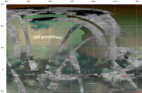
Rev 167 (T84) groundtrack from Ciclops looking ahead is projected on a recent VIMS map of Titan containing RADAR swaths and a grid http://planetarynames.wr.usgs.gov/images/T...p_VIMSimage.pdf I presume the swath will fill in the central portion of the map close to the groundtrack.
Some raw images from the NAC near the Adiri region (from June 7th and 9th) are shown below.
|
||
 |
 
|
||
|
Jan 23 2014, 05:07 AM
Post
#2
|
|||
|
Member Group: Members Posts: 699 Joined: 1-April 08 From: Minnesota ! Member No.: 4081 |
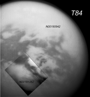
The T84 flyby provided bountiful SAR data including a HiSAR view of the southern and western end of Kraken Mare best seen in the N polar image of Titans seas http://photojournal.jpl.nasa.gov/catalog/PIA17655 and in Fig 9 of Lorenz paper on Titan topography(reference below). The latter included the T83 and T84 swaths in their entirety. These are not yet displayed on VPs awesome web site http://pirlwww.lpl.arizona.edu/~perry/RADAR/
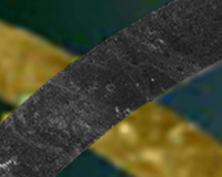
of cylindrical SAR map but the jpeg images are found there. T84 SAR filled in some gaps in the northern trailing hemisphere, across a bland area below Kraken. A couple of interesting portions of the T84 radar data are highlighted in the figure below (top image on the left). The background is a combination of VIMS http://planetarynames.wr.usgs.gov/images/T...p_VIMSimage.pdf and Fig9 of the Lorenz et al paper http://www.sciencedirect.com/science/artic...019103513001620 and covers the northwestern quadrant of Titan. The first image of the animated gif is the T84 HiSAR covering Kraken. The head and neck of the monster sea is apparent. Next the T84 SAR arcs gracefully crossing several north-south SARs including T21 and T19. An interesting part of T84 is its most northern reach where there is some overlap with the HiSAR image. A left-facing crocodile face provides a recognizable overlap point. Up close this area is fascinating (to myself at least) and seems to show rugged higher ground (no topo data as yet) on the left and to the right eroded land with empty lakes and isolated islands and possible rivers, perhaps a remnant of an expanded Kraken sea bottom of the past. In the b section of the T84 swath appear bright circular objects that appear to be degraded and partially filled in impact craters. The second image shows the overlap region of T84 with T21. The same, lonely oval crater rim is readily visible in both SARs.
|
||
|
|
|
||
|
Jan 27 2014, 06:50 PM
Post
#3
|
||
|
Member Group: Members Posts: 699 Joined: 1-April 08 From: Minnesota ! Member No.: 4081 |
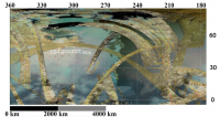
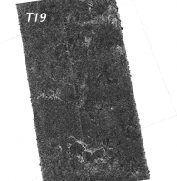
The T84 T19 crossing is shown below. Lots of craterform structures visible. Is there a consensus as to whether these are impact craters vs empty lakes or calderas?
|
|
|
|
|
|
|
Jan 27 2014, 11:37 PM
Post
#4
|
|
 Senior Member Group: Moderator Posts: 2785 Joined: 10-November 06 From: Pasadena, CA Member No.: 1345 |
That depends on who you ask.

-------------------- Some higher resolution images available at my photostream: http://www.flickr.com/photos/31678681@N07/
|
|
|
|
|

|
Lo-Fi Version | Time is now: 30th April 2024 - 05:07 AM |
|
RULES AND GUIDELINES Please read the Forum Rules and Guidelines before posting. IMAGE COPYRIGHT |
OPINIONS AND MODERATION Opinions expressed on UnmannedSpaceflight.com are those of the individual posters and do not necessarily reflect the opinions of UnmannedSpaceflight.com or The Planetary Society. The all-volunteer UnmannedSpaceflight.com moderation team is wholly independent of The Planetary Society. The Planetary Society has no influence over decisions made by the UnmannedSpaceflight.com moderators. |
SUPPORT THE FORUM Unmannedspaceflight.com is funded by the Planetary Society. Please consider supporting our work and many other projects by donating to the Society or becoming a member. |
|