Opportunity Route Map |

  |
Opportunity Route Map |
 Oct 10 2017, 09:26 AM Oct 10 2017, 09:26 AM
Post
#3541
|
||
|
Solar System Cartographer  Group: Members Posts: 10145 Joined: 5-April 05 From: Canada Member No.: 227 |
You may be right!
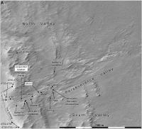
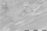
A drive uphill on sol 4874, back to a prominent groove which was imaged a few sols ago. Although it's close to my 45 km marker, you should be aware that the marker is only approximately located. Phil
-------------------- ... because the Solar System ain't gonna map itself.
Also to be found posting similar content on https://mastodon.social/@PhilStooke NOTE: everything created by me which I post on UMSF is considered to be in the public domain (NOT CC, public domain) |
|
 |
 
|
|
|
Oct 21 2017, 07:32 PM
Post
#3542
|
||
|
Solar System Cartographer Group: Members Posts: 10145 Joined: 5-April 05 From: Canada Member No.: 227 |
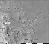
I am ignoring the small move on sol 4883, which was uphill about 40 cm and down about the same amount resulting in no net change to speak of. On sol 4885 we moved about 3 m downslope again. This map has a few minor corrections to the path.
Phil
-------------------- ... because the Solar System ain't gonna map itself.
Also to be found posting similar content on https://mastodon.social/@PhilStooke NOTE: everything created by me which I post on UMSF is considered to be in the public domain (NOT CC, public domain) |
|
|
|
|
|
|
Oct 26 2017, 08:10 PM
Post
#3543
|
||
|
Solar System Cartographer Group: Members Posts: 10145 Joined: 5-April 05 From: Canada Member No.: 227 |
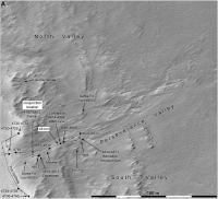
Another 3 m or so downslope on sol 4890. EDIT - no, I plotted the vector backwards, they went back uphill. Map correction will follow very shortly. EDIT - now corrected!
PS thanks Fredk for pointing out my mistake. Phil
-------------------- ... because the Solar System ain't gonna map itself.
Also to be found posting similar content on https://mastodon.social/@PhilStooke NOTE: everything created by me which I post on UMSF is considered to be in the public domain (NOT CC, public domain) |
|
|
|
|
|
|
Oct 29 2017, 06:15 PM
Post
#3544
|
||
|
Solar System Cartographer Group: Members Posts: 10145 Joined: 5-April 05 From: Canada Member No.: 227 |
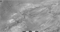
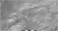
Here is the final result of that mapping I was illustrating in the other thread. The surface images (after a few additions) were roughly fitted to HiRISE features... NOT with the benefit of a detailed DTM, just warping to match features reasonably well. Now the detailed movements can be plotted more reliably. LOcations here are fixed by locating rover wheels in the hazcam views.
Phil
-------------------- ... because the Solar System ain't gonna map itself.
Also to be found posting similar content on https://mastodon.social/@PhilStooke NOTE: everything created by me which I post on UMSF is considered to be in the public domain (NOT CC, public domain) |
|
|
|
|
|
|
Nov 15 2017, 01:08 AM
Post
#3545
|
||
|
Solar System Cartographer Group: Members Posts: 10145 Joined: 5-April 05 From: Canada Member No.: 227 |
A drive on sol 4907 to another part of the rocky outcrop.
Phil
-------------------- ... because the Solar System ain't gonna map itself.
Also to be found posting similar content on https://mastodon.social/@PhilStooke NOTE: everything created by me which I post on UMSF is considered to be in the public domain (NOT CC, public domain) |
|
|
|
|
|
|
Nov 28 2017, 08:47 PM
Post
#3546
|
||
|
Solar System Cartographer Group: Members Posts: 10145 Joined: 5-April 05 From: Canada Member No.: 227 |
We drove again on sol 4922, nearly 15 m further down the valley.
Phil
-------------------- ... because the Solar System ain't gonna map itself.
Also to be found posting similar content on https://mastodon.social/@PhilStooke NOTE: everything created by me which I post on UMSF is considered to be in the public domain (NOT CC, public domain) |
|
|
|
|
|
|
Dec 12 2017, 01:39 AM
Post
#3547
|
||
|
Solar System Cartographer Group: Members Posts: 10145 Joined: 5-April 05 From: Canada Member No.: 227 |
Strolling down the valley again on sol 4934... towards a very interesting-looking area with a divided channel and a bar or island-type structure.
Phil
-------------------- ... because the Solar System ain't gonna map itself.
Also to be found posting similar content on https://mastodon.social/@PhilStooke NOTE: everything created by me which I post on UMSF is considered to be in the public domain (NOT CC, public domain) |
|
|
|
|
|
|
Dec 24 2017, 09:28 PM
Post
#3548
|
||
|
Solar System Cartographer Group: Members Posts: 10145 Joined: 5-April 05 From: Canada Member No.: 227 |
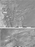
No new drive yet but a new close-up map of this area.
Phil
-------------------- ... because the Solar System ain't gonna map itself.
Also to be found posting similar content on https://mastodon.social/@PhilStooke NOTE: everything created by me which I post on UMSF is considered to be in the public domain (NOT CC, public domain) |
|
|
|
|
|
|
Jan 4 2018, 08:36 PM
Post
#3549
|
||
|
Solar System Cartographer Group: Members Posts: 10145 Joined: 5-April 05 From: Canada Member No.: 227 |
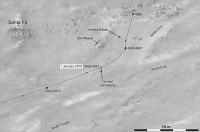
As Fredk said in another thread, we are taking the northern route around the elongated feature in the channel. The new pictures suggest it is a rock outcrop which diverted flow rather than a depositional feature (bar), though it has since weathered until it may no longer be a positive relief feature.
Phil
-------------------- ... because the Solar System ain't gonna map itself.
Also to be found posting similar content on https://mastodon.social/@PhilStooke NOTE: everything created by me which I post on UMSF is considered to be in the public domain (NOT CC, public domain) |
|
|
|
|
|
|
Jan 20 2018, 11:34 PM
Post
#3550
|
||
|
Solar System Cartographer Group: Members Posts: 10145 Joined: 5-April 05 From: Canada Member No.: 227 |
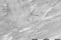
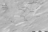
Update to sol 4968, with a drive to the north to look at some rocks.
I noticed that the scale on the previous version of this map was incorrect - it had been pasted in but not rescaled properly. This should be good now. Phil
-------------------- ... because the Solar System ain't gonna map itself.
Also to be found posting similar content on https://mastodon.social/@PhilStooke NOTE: everything created by me which I post on UMSF is considered to be in the public domain (NOT CC, public domain) |
|
|
|
|
|
|
Jan 23 2018, 11:27 PM
Post
#3551
|
||
|
Solar System Cartographer Group: Members Posts: 10145 Joined: 5-April 05 From: Canada Member No.: 227 |
About a 1 m drive on sol 4975 to interesting rocks on the edge of a smooth depression.
I realize now how much I have come to rely on Midnight Planets. I hope its current difficulties will be resolved. It's an amazing resource, and I would say a model for how JPL might structure its rover image sites in future. Phil
-------------------- ... because the Solar System ain't gonna map itself.
Also to be found posting similar content on https://mastodon.social/@PhilStooke NOTE: everything created by me which I post on UMSF is considered to be in the public domain (NOT CC, public domain) |
|
|
|
|
|
|
Jan 23 2018, 11:59 PM
Post
#3552
|
|
 Senior Member Group: Members Posts: 4246 Joined: 17-January 05 Member No.: 152 |
Luckily http://curiosityrover.com/ is back in operation again.
|
|
|
|
|
Feb 5 2018, 08:31 PM
Post
#3553
|
||
|
Solar System Cartographer Group: Members Posts: 10145 Joined: 5-April 05 From: Canada Member No.: 227 |
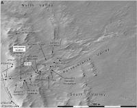
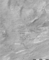
No move, but an updated map. Locations of many named features are still uncertain to me at this stage.
Phil
-------------------- ... because the Solar System ain't gonna map itself.
Also to be found posting similar content on https://mastodon.social/@PhilStooke NOTE: everything created by me which I post on UMSF is considered to be in the public domain (NOT CC, public domain) |
|
|
|
|
|
|
Feb 7 2018, 07:17 PM
Post
#3554
|
||
|
Solar System Cartographer Group: Members Posts: 10145 Joined: 5-April 05 From: Canada Member No.: 227 |
We had a drive of a few meters on sol 4990, backing out of the rocky area we were just looking at. My impression is that the drive covered less distance than expected, probably because of wheel slip on the rough sloping terrain.
Phil
-------------------- ... because the Solar System ain't gonna map itself.
Also to be found posting similar content on https://mastodon.social/@PhilStooke NOTE: everything created by me which I post on UMSF is considered to be in the public domain (NOT CC, public domain) |
|
|
|
|
|
|
Feb 7 2018, 07:59 PM
Post
#3555
|
|
|
Member Group: Admin Posts: 976 Joined: 29-September 06 From: Pasadena, CA - USA Member No.: 1200 |
QUOTE (Phil Stooke @ Feb 7 2018, 11:17 AM)  We had a drive of a few meters on sol 4990, backing out of the rocky area we were just looking at. My impression is that the drive covered less distance than expected, probably because of wheel slip on the rough sloping terrain. ... Actually the goal of the Sol 4990 drive was to change heading towards a rock to the North Wall. Since we did not have enough room to maneuver forwards, we did a setup drive backwards. The Sol 4991 did a forward bump which stopped a tad earlier to ensure we still have enough room to get to the intended target. The final bump to have the target in the IDD work plane should hopefully happen soon, maybe by this weekend? Paolo -------------------- Disclaimer: all opinions, ideas and information included here are my own,and should not be intended to represent opinion or policy of my employer.
|
|
|
|
|

|
Lo-Fi Version | Time is now: 17th April 2024 - 12:47 PM |
|
RULES AND GUIDELINES Please read the Forum Rules and Guidelines before posting. IMAGE COPYRIGHT |
OPINIONS AND MODERATION Opinions expressed on UnmannedSpaceflight.com are those of the individual posters and do not necessarily reflect the opinions of UnmannedSpaceflight.com or The Planetary Society. The all-volunteer UnmannedSpaceflight.com moderation team is wholly independent of The Planetary Society. The Planetary Society has no influence over decisions made by the UnmannedSpaceflight.com moderators. |
SUPPORT THE FORUM Unmannedspaceflight.com is funded by the Planetary Society. Please consider supporting our work and many other projects by donating to the Society or becoming a member. |
|