Apollo Sites from LRO |

  |
Apollo Sites from LRO |
 Apr 19 2017, 04:02 PM Apr 19 2017, 04:02 PM
Post
#436
|
|
 Senior Member  Group: Members Posts: 1729 Joined: 3-August 06 From: 43° 35' 53" N 1° 26' 35" E Member No.: 1004 |
QUOTE (GoneToPlaid @ Apr 19 2017, 04:23 PM)  How big is the retro rocket? my sources say a sphere 94 cm (3 ft) across |
 |
 
|
|
Apr 19 2017, 04:06 PM
Post
#437
|
|
|
Senior Member Group: Members Posts: 2511 Joined: 13-September 05 Member No.: 497 |
QUOTE (GoneToPlaid @ Apr 19 2017, 07:23 AM) How big is the retro rocket? I'm pretty sure Surveyor used an early version of the Star-37 -- http://www.astronautix.com/s/star37.html -- so 0.66 meters in diameter. -------------------- Disclaimer: This post is based on public information only. Any opinions are my own.
|
|
|
|
|
Apr 19 2017, 04:09 PM
Post
#438
|
|
 Junior Member Group: Members Posts: 31 Joined: 24-February 17 From: California Member No.: 8127 |
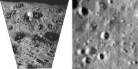
QUOTE (Phil Stooke @ Apr 5 2017, 06:18 AM) This is my interpretation of the field of view of the Apollo image AS12-46-6759. First a rough perspective view of the image to help identify features near the horizon. [attachment=41144:AS12_46_...rsp_post.jpg] And a broader LROC view of the area: [attachment=41146:AS12_46_...iew_post.jpg] The prominent crater with a little crater on its near rim (A) is not the larger one near the retro-rocket impact - B. If B is visible at all it is the one barely visible near the right edge and horizon. I don't thing the retro-rocket casing would be visible at all, given the poor focus and the distance. In particular it's not the nice round object just beyond A. Phil A in your reprojected view of AS12-46-6749 really is B as labeled in your LRO overhead view. The terrain towards the Surveyor III retro rocket impact site actually is somewhat up-slope from the landing site -- just a bit more than enough up-slope to counter the local curvature of the lunar surface when looking towards the retro rocket impact site from near the lunar module. Although you postulated that the retro rocket might be resting on the lip of its created crater, to me and in my deconvolved images the retro rocket appears to be resting at the center of the crater. The nozzle is perhaps casting a very fine yet distinct shadow within the crater. The lip on the crater appears to be just that -- a crater lip and not the retro rocket itself. AS12-46-6738 also appears to show the Surveyor III retro rocket impact site. I will post enhanced photos of this particular image. |
|
|
|
|
Apr 19 2017, 06:34 PM
Post
#439
|
||
|
Solar System Cartographer Group: Members Posts: 10151 Joined: 5-April 05 From: Canada Member No.: 227 |
It's very difficult to match points between surface and overhead views, and I have certainly made many mistakes in the past. That's why I like to stretch out the image in a reprojection. But in this case I think my matching features were correct.
Here is a direct comparison between the roughly projected view and a greatly enlarged LROC NAC image (M162466771L). Over 20 points of correspondence can be mapped. Number 15 is my previous crater A. Out at the edge, beyond my points 14 and 21, the surface drops into a shallow crater, and my previous crater B is seen where its far rim rises up again, twice as far away, but still short of the retro-rocket. Phil
-------------------- ... because the Solar System ain't gonna map itself.
Also to be found posting similar content on https://mastodon.social/@PhilStooke Maps for download (free PD: https://upload.wikimedia.org/wikipedia/comm...Cartography.pdf NOTE: everything created by me which I post on UMSF is considered to be in the public domain (NOT CC, public domain) |
|
|
|
|
|
|
Apr 19 2017, 09:14 PM
Post
#440
|
||
|
Junior Member Group: Members Posts: 31 Joined: 24-February 17 From: California Member No.: 8127 |
QUOTE (Phil Stooke @ Apr 19 2017, 11:34 AM) It's very difficult to match points between surface and overhead views, and I have certainly made many mistakes in the past. That's why I like to stretch out the image in a reprojection. But in this case I think my matching features were correct. Here is a direct comparison between the roughly projected view and a greatly enlarged LROC NAC image (M162466771L). Over 20 points of correspondence can be mapped. Number 15 is my previous crater A. Out at the edge, beyond my points 14 and 21, the surface drops into a shallow crater, and my previous crater B is seen where its far rim rises up again, twice as far away, but still short of the retro-rocket. Phil
That matching is spot on! |
|
|
|
|
|
|
May 1 2017, 08:33 AM
Post
#441
|
||||||
 Member Group: Members Posts: 238 Joined: 15-January 13 Member No.: 6842 |
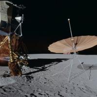
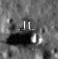
QUOTE (James Fincannon @ Apr 10 2017, 05:42 PM) I do not understand how you can see it is "clearly visible". For one thing, do we know where the antenna is? Is it on its side to cast a thick shadow or what? I would need to calculate the length of the flag shadow (not including the pole) for the shallowest sun elevation images to confirm this is likely a flag shadow. It did not jump out at me at the time as being obvious, but maybe I was wrong. In the Flip Book (which is indeed an excellent and fun way to analyse the terrain and Apollo stuff on the ground), around the 9:00 to 11:00 time marks, I can see the flag's shadow clearly. It appears to be detached from the ground, which is what a flag's shadow does because it's on a pole, at some elevation from the ground:
A darkish area appears on the image at around 8:20 time mark, indicated here in an enhanced image:
I believe this is the actual location of the flag, showing the disturbed lunar soil:
The antenna doesn't really cast much of a shadow, it looks very pale in LROC images:
And MET's shadow stays attached to it, as it's sitting directly on the ground. It is visible earlier in the morning (if you move the slider from right to left), before the flag's shadow becomes clearly visible. -------------------- Curiosity rover panoramas: http://www.facebook.com/CuriosityRoverPanoramas
My Photosynth panoramas: http://photosynth.net/userprofilepage.aspx...;content=Synths |
|||||
|
|
|
|||||
|
May 2 2017, 11:05 AM
Post
#442
|
|||
|
Member Group: Members Posts: 238 Joined: 15-January 13 Member No.: 6842 |
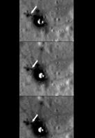
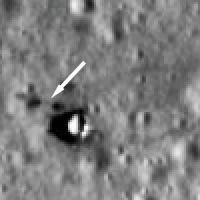
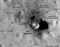
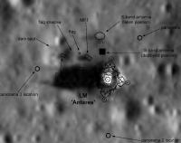
QUOTE (Phil Stooke @ Apr 10 2017, 06:01 PM) In my site map I show a 'dark spot'. I am having trouble figuring out what it is. We have good images of the area from the LM window and nothing obvious shows up. Phil I have overlayed your schematic over a couple of LROC images at different sun angles (only your arrows, etc. remain, the background is now from different images). The first one, where a PLSS is clearly visible:
It looks like the dark spot is just a subtle part of landscape, either some soil that was kicked up by the PLSS, or just a quirk of terrain (it's inside a very shallow crater) Here's a second image, where that area is more directly illuminated by the rising Sun:
-------------------- Curiosity rover panoramas: http://www.facebook.com/CuriosityRoverPanoramas
My Photosynth panoramas: http://photosynth.net/userprofilepage.aspx...;content=Synths |
||
|
|
|
||
|
May 3 2017, 01:53 AM
Post
#443
|
|
|
Solar System Cartographer Group: Members Posts: 10151 Joined: 5-April 05 From: Canada Member No.: 227 |
Nice images! The dark spot puzzles me because it doesn't seem to move with changing sun height, so it is on the surface, but there is absolutely nothing there in the images from the LM window after EVA 2. I have wondered if it was a bit of material thrown there during the LM liftoff, though usually when we see that it is bright, not dark (e.g around Apollo 11 in LRO images).
Phil -------------------- ... because the Solar System ain't gonna map itself.
Also to be found posting similar content on https://mastodon.social/@PhilStooke Maps for download (free PD: https://upload.wikimedia.org/wikipedia/comm...Cartography.pdf NOTE: everything created by me which I post on UMSF is considered to be in the public domain (NOT CC, public domain) |
|
|
|
|
May 3 2017, 09:07 AM
Post
#444
|
|
|
Member Group: Members Posts: 238 Joined: 15-January 13 Member No.: 6842 |
QUOTE (Phil Stooke @ May 3 2017, 02:53 AM) Nice images! The dark spot puzzles me because it doesn't seem to move with changing sun height, so it is on the surface, but there is absolutely nothing there in the images from the LM window after EVA 2. I have wondered if it was a bit of material thrown there during the LM liftoff, though usually when we see that it is bright, not dark (e.g around Apollo 11 in LRO images). Phil The "dark spot" only shows up clearly in high sun angle NAC images, suggesting that it's simly rougher soil that doesn't reflect as much sunlight directly upwards as the surrounding area (same as with astronauts' foot tracks and other disturbed soil areas (however, the roughness in this case might be completely natural)). This roughness and the effect it produces wouldn't be obvious from a shallow-angle Apollo photo from the LM. These are all just my musings, of course, based on what I see in the images. -------------------- Curiosity rover panoramas: http://www.facebook.com/CuriosityRoverPanoramas
My Photosynth panoramas: http://photosynth.net/userprofilepage.aspx...;content=Synths |
|
|
|
|
May 3 2017, 02:06 PM
Post
#445
|
|
|
Solar System Cartographer Group: Members Posts: 10151 Joined: 5-April 05 From: Canada Member No.: 227 |
These are two Apollo 14 images taken from the LM windows:
Pre-EVA 1: https://www.hq.nasa.gov/alsj/a14/AS14-65-9204HR.jpg (lower left corner) Post-EVA 2: https://www.hq.nasa.gov/alsj/a14/AS14-66-9338HR.jpg (left of centre, just beyond the flag shadow) I just find it surprising that there is not something more obvious at that location. A little crater might contribute a bit, but it's very small. I mentioned the possibility of a bit of LM descent stage material blown off by the ascent stage during launch, and it occurs to me now that an item like that might have scuffed the surface before being blown further away, creating disturbed soil after the last surface image was taken. Phil -------------------- ... because the Solar System ain't gonna map itself.
Also to be found posting similar content on https://mastodon.social/@PhilStooke Maps for download (free PD: https://upload.wikimedia.org/wikipedia/comm...Cartography.pdf NOTE: everything created by me which I post on UMSF is considered to be in the public domain (NOT CC, public domain) |
|
|
|
|
Mar 27 2019, 08:23 PM
Post
#446
|
||
|
Solar System Cartographer Group: Members Posts: 10151 Joined: 5-April 05 From: Canada Member No.: 227 |
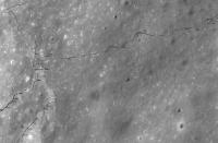
I am mapping the Apollo traverses using tracks visible in LRO images where possible and matching photos taken from the LRV during the drive to LRO images when tracks are invisible. Here is the area around Hole in the Wall, Apollo 17 EVA 2, which is always misrepresented on published maps. It's a work in progress but it shows how the LRV approached the scarp, then Cernan saw an obstacle (a pit) in the mouth of the gap, turned sharply to the southeast, then back and up the slope to the left (south) of a crater. This matches the transcript on the Apollo Lunar Surface Journal at that point. All published maps that I am aware of show the rover head straight for a steep part of the scarp a bit further south and up and over it. I am making plans to publish all this work eventually. This of course is just the rough working map, but I thought some people might find it interesting.
Phil
-------------------- ... because the Solar System ain't gonna map itself.
Also to be found posting similar content on https://mastodon.social/@PhilStooke Maps for download (free PD: https://upload.wikimedia.org/wikipedia/comm...Cartography.pdf NOTE: everything created by me which I post on UMSF is considered to be in the public domain (NOT CC, public domain) |
|
|
|
|
|
|
Mar 28 2019, 03:44 PM
Post
#447
|
|
 Member Group: Members Posts: 547 Joined: 1-May 06 From: Scotland (Ecosse, Escocia) Member No.: 759 |
Great to have that one finally resolved, Phil.
We had often thought that the post-mission traverse maps were wrong. Many thanks! |
|
|
|
|
Mar 28 2019, 04:13 PM
Post
#448
|
|
|
Newbie Group: Members Posts: 10 Joined: 26-November 18 From: Billericay, England Member No.: 8485 |
It amazes me how you are able to ID the LRV photography locations. I looked at a few on this part of EVA-2, and I can only agree with your positioning. How do you do that?
Can't wait to see the completed work. |
|
|
|
|
Mar 28 2019, 11:29 PM
Post
#449
|
|
 Member Group: Members Posts: 699 Joined: 3-December 04 From: Boulder, Colorado, USA Member No.: 117 |
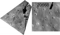
Very nice! Looks like there's one typo on the map- the highest-numbered location should be 21137, not 22137.
It was fun hearing Harrison Schmitt himself talk about Shorty Crater at LPSC last week. Also at LPSC, Carter Emmart had a cool VR exhibit incorporating Apollo 17 surface photography, including some of the large boulders, into a VR environment, allowing you to get up close and check out the rock textures. John |
|
|
|
|
Mar 29 2019, 06:59 AM
Post
#450
|
||
|
Solar System Cartographer Group: Members Posts: 10151 Joined: 5-April 05 From: Canada Member No.: 227 |
There's always a typo! There was one on my poster.
This is what I do to help locate these images. I do a partial reprojection - not meant to be accurate, but enough to make the image easier to compare with the LRO image. Plus a contrast enhancement if necessary, as it usually is. This one is south of Hole in the Wall. I have done it for almost every image taken from the rover, but I haven't actually located every one.... All this work will be on the Apollo Lunar Surface Journal for all 3 rover missions, as well as whatever I may have planned for publication. Schmitt on Shorty: There is a subdued crater a bit bigger than Shorty and abutting it on the south, never named before, but at LPSC he called it 'Fitzgibbon'. He said there was a story behind it, but he didn't tell it. The crater is significant because samples suggested an exposure age of 17 M years and he thought Shorty should be younger than that. Now he has an age for Shorty of 3 M years, so he thought the 17 M years age was for 'Fitzgibbon'. But here's the meaning of that name. Jack Schmitt's wife's family name was Fitzgibbon. At a meeting last year he said he had to name a crater after her because she was looking over his shoulder as he prepared that presentation. I think he was talking about a different crater last year than he mentioned this year, up near the scarp. Always the joker, our Harrison. Phil
-------------------- ... because the Solar System ain't gonna map itself.
Also to be found posting similar content on https://mastodon.social/@PhilStooke Maps for download (free PD: https://upload.wikimedia.org/wikipedia/comm...Cartography.pdf NOTE: everything created by me which I post on UMSF is considered to be in the public domain (NOT CC, public domain) |
|
|
|
|
|
|

|
Lo-Fi Version | Time is now: 25th April 2024 - 06:27 AM |
|
RULES AND GUIDELINES Please read the Forum Rules and Guidelines before posting. IMAGE COPYRIGHT |
OPINIONS AND MODERATION Opinions expressed on UnmannedSpaceflight.com are those of the individual posters and do not necessarily reflect the opinions of UnmannedSpaceflight.com or The Planetary Society. The all-volunteer UnmannedSpaceflight.com moderation team is wholly independent of The Planetary Society. The Planetary Society has no influence over decisions made by the UnmannedSpaceflight.com moderators. |
SUPPORT THE FORUM Unmannedspaceflight.com is funded by the Planetary Society. Please consider supporting our work and many other projects by donating to the Society or becoming a member. |
|