Opportunity Route Map |

  |
Opportunity Route Map |
 Dec 8 2005, 06:31 PM Dec 8 2005, 06:31 PM
Post
#931
|
||
|
Solar System Cartographer  Group: Members Posts: 10151 Joined: 5-April 05 From: Canada Member No.: 227 |
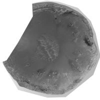
This is another part of an Opportunity base map for route mapping. It's incomplete and low resolution here, a work in progress, but I'll post a complete high res version later.
This is Endurance crater. Two big pans were made from nearly opposite points on sols around 97 and 120 (I'm not looking at my notes here...) I took the first pan, plus a MOC cPROTO image, greatly enlarged, and reprojected the pan to fit the MOC image. This was not from a terrain model, but by rubber-sheeting using a thin plate spline method and 100 tie points. I'm using the geocorrection module in a GIS to do this. Incidentally I really need a good freeware rubber-sheeting program with a spline option (polynomials don't work properly for this). Any suggestions? The first pan gives great results everywhere except right under the rover where the slope is too distorted. When the second pan is done, it will fill that gap. I'm working at much higher resolution than this image shows, of course. Phil
-------------------- ... because the Solar System ain't gonna map itself.
Also to be found posting similar content on https://mastodon.social/@PhilStooke Maps for download (free PD: https://upload.wikimedia.org/wikipedia/comm...Cartography.pdf NOTE: everything created by me which I post on UMSF is considered to be in the public domain (NOT CC, public domain) |
|
 |
 
|
|
|
Dec 8 2005, 09:41 PM
Post
#932
|
|
 Member Group: Members Posts: 531 Joined: 24-August 05 Member No.: 471 |
Absolutely fantastic!!
 Thanks Phil! -------------------- - blue_scape / Nico -
|
|
|
|
|
Dec 9 2005, 03:48 AM
Post
#933
|
|
|
Senior Member Group: Members Posts: 1636 Joined: 9-May 05 From: Lima, Peru Member No.: 385 |
Awesome picture. I don't see any Oppy's track. Shall anyone point which side is north. I think that Oppy entered into Endurance Crater on the south side?
Rodolfo |
|
|
|
|
Dec 9 2005, 04:21 AM
Post
#934
|
|
 Senior Member Group: Moderator Posts: 2262 Joined: 9-February 04 From: Melbourne - Oz Member No.: 16 |
QUOTE (RNeuhaus @ Dec 9 2005, 02:48 PM) Awesome picture. I don't see any Oppy's track. Shall anyone point which side is north. I think that Oppy entered into Endurance Crater on the south side? Rodolfo  You won't see any tracks as, as Phil said this is made using the first of the two pans made before Oppy entered Endurance. This being Phils work I would be fairly sure that North is up.  Didn't Oppy enter Endurance from the west side? Burns cliff and 'escape hatch' are are on the south side. -------------------- |
|
|
|
|
Dec 9 2005, 07:28 AM
Post
#935
|
|
 Senior Member Group: Members Posts: 2228 Joined: 1-December 04 From: Marble Falls, Texas, USA Member No.: 116 |
Damn Phil. That is nice work.
-------------------- ...Tom
I'm not a Space Fan, I'm a Space Exploration Enthusiast. |
|
|
|
|
Dec 9 2005, 10:33 AM
Post
#936
|
|
 Chief Assistant Group: Admin Posts: 1409 Joined: 5-January 05 From: Ierapetra, Greece Member No.: 136 |
 Congrats Phil. A terrific work in progress! Congrats Phil. A terrific work in progress!Nico 
-------------------- photographer, space imagery enthusiast, proud father and partner, and geek.
http://500px.com/sacred-photons & |
|
|
|
|
Dec 9 2005, 02:59 PM
Post
#937
|
||
|
Solar System Cartographer Group: Members Posts: 10151 Joined: 5-April 05 From: Canada Member No.: 227 |
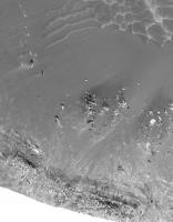
Thanks for the nice comments. North is at the top... the pans were made from the west and southeast sides, and Opportunity entered and exited the crater on the southwest.
Here's part of the same image (with a few adjustments) blown up to illustrate the real resolution. This view contains most of the area traversed by Opportunity, but not Karatepe which has to come from the other pan. Phil
-------------------- ... because the Solar System ain't gonna map itself.
Also to be found posting similar content on https://mastodon.social/@PhilStooke Maps for download (free PD: https://upload.wikimedia.org/wikipedia/comm...Cartography.pdf NOTE: everything created by me which I post on UMSF is considered to be in the public domain (NOT CC, public domain) |
|
|
|
|
|
|
Dec 9 2005, 03:14 PM
Post
#938
|
|
|
Founder Group: Chairman Posts: 14432 Joined: 8-February 04 Member No.: 1 |
Am I the only one who finds the route around Endurance a little confusing - I still cant pick out Ellesmere, Wopmay etc from overhead views, it's quite confusing.
Doug |
|
|
|
|
Dec 9 2005, 03:30 PM
Post
#939
|
|
|
Solar System Cartographer Group: Members Posts: 10151 Joined: 5-April 05 From: Canada Member No.: 227 |
Doug, I'll do some labelling later. It's true the press release stuff has not been great in this regard. But that's where we come in.
Phil -------------------- ... because the Solar System ain't gonna map itself.
Also to be found posting similar content on https://mastodon.social/@PhilStooke Maps for download (free PD: https://upload.wikimedia.org/wikipedia/comm...Cartography.pdf NOTE: everything created by me which I post on UMSF is considered to be in the public domain (NOT CC, public domain) |
|
|
|
|
Dec 9 2005, 03:48 PM
Post
#940
|
|
|
Founder Group: Chairman Posts: 14432 Joined: 8-February 04 Member No.: 1 |
Top stuff :0
Doug |
|
|
|
|
Dec 9 2005, 04:25 PM
Post
#941
|
||
 Member Group: Members Posts: 345 Joined: 2-May 05 Member No.: 372 |
(Yes, it is a word, just not a real one.) |
|
|
|
|
|
|
Dec 10 2005, 03:05 AM
Post
#942
|
||
|
Solar System Cartographer Group: Members Posts: 10151 Joined: 5-April 05 From: Canada Member No.: 227 |
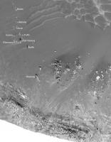
Let's not overlook the great work of Pando and Dilo and Tesheiner on mapping Mars! And all our panorama-makers, without whom maps are much harder to make.
Here is an annotated version of my last map. There must be many more names, but these are the ones which showed up on JPL graphics and status reports. In fact, I would be very interested in other names if people would care to add them, from sources like the targeting info etc. Actually, we really need a systematic collection and graphic presentation of all these names used during the mission. Phil
-------------------- ... because the Solar System ain't gonna map itself.
Also to be found posting similar content on https://mastodon.social/@PhilStooke Maps for download (free PD: https://upload.wikimedia.org/wikipedia/comm...Cartography.pdf NOTE: everything created by me which I post on UMSF is considered to be in the public domain (NOT CC, public domain) |
|
|
|
|
|
|
Dec 10 2005, 08:07 PM
Post
#943
|
|
 Member Group: Members Posts: 257 Joined: 18-December 04 Member No.: 123 |
QUOTE (Phil Stooke @ Dec 10 2005, 03:05 AM) Let's not overlook the great work of Pando and Dilo and Tesheiner on mapping Mars! Absolutely right, and that mapping work has attracted almost 97,000 views as of today!! Nice one.
-------------------- Turn the middle side topwise....TOPWISE!!
|
|
|
|
|
Dec 10 2005, 08:27 PM
Post
#944
|
|
|
Member Group: Members Posts: 345 Joined: 2-May 05 Member No.: 372 |
QUOTE (Phil Stooke @ Dec 9 2005, 10:05 PM) Let's not overlook the great work of Pando and Dilo and Tesheiner on mapping Mars! And all our panorama-makers, without whom maps are much harder to make. Phil True, true. But they didn't do any rubber-sheeting! And plus, there can be only one #1. However, if you prefer the award (ok, so it's not much of an award) go to someone else, that can easily be arranged. |
|
|
|
|
Dec 11 2005, 03:26 AM
Post
#945
|
|
|
Solar System Cartographer Group: Members Posts: 10151 Joined: 5-April 05 From: Canada Member No.: 227 |
I appreciate it, um3k, I just don't want to take all the glory.
I'm having a hard time getting a map of the west outer rim of Endurance to come together. But eventually... Phil -------------------- ... because the Solar System ain't gonna map itself.
Also to be found posting similar content on https://mastodon.social/@PhilStooke Maps for download (free PD: https://upload.wikimedia.org/wikipedia/comm...Cartography.pdf NOTE: everything created by me which I post on UMSF is considered to be in the public domain (NOT CC, public domain) |
|
|
|
|

|
Lo-Fi Version | Time is now: 26th April 2024 - 08:59 AM |
|
RULES AND GUIDELINES Please read the Forum Rules and Guidelines before posting. IMAGE COPYRIGHT |
OPINIONS AND MODERATION Opinions expressed on UnmannedSpaceflight.com are those of the individual posters and do not necessarily reflect the opinions of UnmannedSpaceflight.com or The Planetary Society. The all-volunteer UnmannedSpaceflight.com moderation team is wholly independent of The Planetary Society. The Planetary Society has no influence over decisions made by the UnmannedSpaceflight.com moderators. |
SUPPORT THE FORUM Unmannedspaceflight.com is funded by the Planetary Society. Please consider supporting our work and many other projects by donating to the Society or becoming a member. |
|