Printable Version of Topic
Click here to view this topic in its original format
Unmanned Spaceflight.com _ Mars Express & Beagle 2 _ Mars Express Color Images
Posted by: DavidVicari Feb 9 2004, 01:40 PM
What do you guys think about the handful of color images released from Mars Express.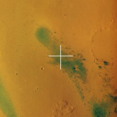
This is the Spirit landing site. The dust devil tracks look way too green to me. Shouldn't they be more red/brown/gray.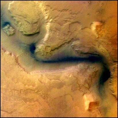
Doesn't this channel look too blue?
Are these supposed to be true color or are they false color in order to enhance features?
If they are true color, is it more accurate then what we have seen from Global Surveyor and Odyssey?
Posted by: dvandorn Feb 9 2004, 08:01 PM
I don't know -- it all depends on how you manipulate the color information, after all. It always seemed to me that the colors of Mars, from Earth-based telescopic imagery and from Hubble images, ranges from the rusty orange-red to a greenish-gray. The greens in the MEX images don't seem all that much *more* green than the greens I've seen in the Hubble images, for example.
Many of the color pan cam images from Spirit seem to show a greenish tinge to much of the landscape that looks not unlike the greens in the MEX images. Again, I think it's a matter of degree. It also may be a human-eye perception issue -- place a greenish-gray amid a lot of orange-red, and the greenish-gray appears even more green due to the contrast between the two colors.
- The Other Doug
Posted by: DavidVicari Feb 10 2004, 09:47 PM
Turns out the color was wrong. They took the Gusev picture off the ESA Mars Express website. Bob Clark on another discussion board found the following.
The colors in the other picture released so far are rather close to true colors but a slight tint in reddish or bluish direction from non-perfect adjustments of the color histograms cannot be excluded due to the somewhat abnormal?"seeing" conditions with large amounts of dust under high sun.
Best regards,
Gerhard Neukum
HRSC Principal Investigator
And here is the corrected image.

Posted by: Bob Shaw Apr 10 2006, 11:54 AM
A couple of interesting MEX links:
http://www.dlr.de/mars/en/desktopdefault.aspx/
http://www.dlr.de/specials/2jahrehrsc/marsgalerie.htm
Bob Shaw
Posted by: ljk4-1 May 24 2006, 03:17 PM
Lava tubes on Pavonis Mons
These images, taken by the High Resolution Stereo Camera (HRSC) on board ESA's
Mars Express, show Pavonis Mons, the central volcano of the three 'shield'
volcanoes that comprise Tharsis Montes.
Full story:
http://www.esa.int/esaSC/SEM8AD9ATME_index_0.html
Posted by: Marz May 24 2006, 03:29 PM

Instant Mars Base? Just use some ice to "weld" an airlock at the mouth of a tunnel, and spray maybe the walls with some ice to make seal any porous fissures... and voila - a warehouse sized living space.
Could we be looking at the site of the first permanent settlement on Mars?
Posted by: Bob Shaw May 24 2006, 05:12 PM
Could we be looking at the site of the first permanent settlement on Mars?
Marz:
Lava tube habitats on both the Moon and Mars have been suggested in the past - they suffer from potentially being *very* sharp and uneroded inside, but of course nobody has seen inside any on either world. On Earth, some spectacular lava tubes have 'skylights' which might allow easy access if such features are replicated elsewhere.
Bob Shaw
Posted by: ustrax Jun 9 2006, 10:11 AM
Impressive and indeed chaotic... 
http://www.esa.int/esaSC/SEMG4O9ATME_index_0.html
Oppy's not far from there...With this resolution would spottable wouldn't she?
EDITED: Looks like Mars Express is chasing the rovers...First on Oppy's back, now near Gusev at Apollinaris:
http://www.esa.int/SPECIALS/Mars_Express/SEM412AATME_1.html#subhead2
Just beatiful! 
Posted by: DDAVIS Jun 9 2006, 03:25 PM
Just beatiful!
[/quote]
In my first try to make a color picture from their data I noticed the different color channels seem to be from different viewpoints as in part of a stereo pair, so only a flat terrain can be easily colour registered. Does one have to make detailed displacement maps in order to make colour channels of elevations line up?
Don
Posted by: elakdawalla Jun 12 2006, 06:16 PM
Yep. The 10 HRSC channels are pointed at different angles along the track, from plus to minus 18.9°; that's how they get continuous stereo coverage, but it does cause problems for building color views, they have to project everything onto a DEM in order to stack them up neatly. I believe that the nadir channel is a panchromatic one, and that the color channels are pointed at relatively low angles off-nadir, but I'm not sure what those angles are. Anybody?
--Emily
Posted by: DDAVIS Jun 12 2006, 07:03 PM
[quote name='elakdawalla' date='Jun 12 2006, 06:16 PM' post='58102']
Yep. The 10 HRSC channels are pointed at different angles along the track, from plus to minus 18.9°; that's how they get continuous stereo coverage, but it does cause problems for building color views, they have to project everything onto a DEM in order to stack them up neatly.
Great, so the problem becomes one of generating DEM files from stereo views (with differing colour details}. What are people using to generate such DEM files? One can try to make contour maps by registering stereo images and drawing lines where they converge, but there must be a better way.
Don
Posted by: elakdawalla Jun 12 2006, 07:20 PM
Well, I think there are at least three panchromatic channels (which they call 'stereo' channels), in fact IIRC there might be five, two pointing down-track, one nadir, and two up-track. I think they generate a DEM from all that stereo data first and then drape the color data across it. That's my impression anyway. It would be interesting to talk to someone on Neukum's team at DLR and find out how much of this process is automated and how much takes human interference.
--Emily
Posted by: djellison Jun 12 2006, 08:02 PM
http://www.dlr.de/en/Desktopdefault.aspx/tabid-11/129_read-2681/ outlines much of the process, Jan-Peter Muller spoke to the BAA in Cambridge last year and said that the process is just about automated with a DEM, the projected colour data all processed within a few hours of reception.
I think, via on-board binning, the colour channels are 4 x 4 binned ( so typically 100m/pixel) whereas Nadir data is unbinned at 25m/pixel....ish
The only angles I've found for the instrument other than the extremes that Emily mentioned, are these from a PDF about the airborne version of HRSC...
Swath Angle 29.1°
Outer Stereo Angle ± 20.5° 520-760 nm
Inner Stereo Angle ± 12°
Nadir Channel 0°
Blue Channel - 4.6° 435-520 nm
Green Channel - 2.3° 522-592 nm
Red Channel + 2.3° 626-686 nm
IR Channel + 4.6° 780-850 nm
I'm not sure how, if at all, that matches up with the space-borne version - but I've noticed some fairly extreme miss-matching just between the IR, G and B channels when looking at harsh elevation such as at Val.Mar.
Doug
Posted by: stevo Jun 14 2006, 11:32 PM
Just beatiful!
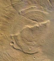
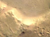
Indeed they are beautiful. I was day-dreaming through the color image above and saw one little crater (approx 2 km in diameter) near the middle of the image with a lot of "stuff" radiating from it. This is in contrast to the vast majority of the other craters in the caldera. It honestly looks like something went "splat". Can someone tell me if this says something about the nature of the impactor, the timing of the impact, or is it a volcanic event, presumably one of the last in this particular caldera ?
Stephen
Posted by: Bob Shaw Jun 15 2006, 09:03 AM
Stephen
Stephen:
That MEX image is indeed full of stunning features.
The 'splat' crater looks unusual, inasmuch as the ejecta blanket appears to show some relief against the surrounding terrain. It's reasonably fresh, but probably not that fresh in Earthly terms. I wonder if there are IR THEMIS images of it, which would tell us if there were any big boulders involved? The whole basin looks to me like a heavily eroded impact crater - there are no features which I'd see as volcanic, so the term 'caldera' would be a misnomer. As for the ejecta blankets around the other, larger crater pair - that's also interesting. It seems highly eroded and 'rotten' near the crater lip, and 'bouldery' (I know the scale is wrong to see boulders, it's just a term I invented to cover the granular texture!) at the rim. perhaps this tells us that the material near the rim - from the deepest pre-impact layers - was more water-rich than the surface deposits which form the outer reaches of the ejecta blanket.
Also of interest in the image must be the excellent fossil crater - you can see the arcuate ridges which define it quite clearly. To have survived, I'd expect that to have been made into good solid bedrock (unlike the rather 'rotten' crater pair in the middle of the big crater).
And there are even nice streaks, too...
I didn't see any water flow features, or volcanoes anywhere - but a history of icy mud, yes...
Bob Shaw

|
|
|
Posted by: stevo Jun 15 2006, 01:19 PM
Bob,
Thanks for the detailed response. I was taking ESA's word for the volcanic thing, it's been 1/2 a lifetime and change since I last studied geology and I remember just enough to understand what people are talking about.
Wouldn't it be fun to be there, just walking around ...
Stephen
Posted by: Malmer Jun 18 2006, 10:07 PM
Since they have the 3d DEM data and know the geometry of the lighting they could easily divide out the shading from the images and create reasonably accurate albedomaps. Have anyone tried this?
Would be nice to have an "unshaded" dataset to be able to render the martian surface under any lighting condition.
I used a stereo correlation software called "ZK stereo" to generate dems from the anaglyphs on the web but its not the greatest software in the world. it could really use some help from shape from shading to improve its solution... and using jpg compressed anaglyphs really doesnt help
I made some simple flybys in open gl that where nice. But the garish colors that ESA used in their first releases really did not help the look too much...
It looks to mee that esa is only using stereo correlation to make their dems. They should use shading information as well to improve the resolution.
/M
Posted by: ustrax Jun 21 2006, 09:53 AM
Margaritifer Terra in full splendor:
http://sci.esa.int/science-e/www/object/index.cfm?fobjectid=39388
Posted by: djellison Jun 27 2006, 07:16 AM
Outer Stereo Angle ± 20.5° 520-760 nm
Inner Stereo Angle ± 12°
Nadir Channel 0°
Blue Channel - 4.6° 435-520 nm
Green Channel - 2.3° 522-592 nm
Red Channel + 2.3° 626-686 nm
IR Channel + 4.6° 780-850 nm
I'm not sure how, if at all, that matches up with the space-borne version - but I've noticed some fairly extreme miss-matching just between the IR, G and B channels when looking at harsh elevation such as at Val.Mar.
Has anyone been able to find something better than these figures?
Doug
Posted by: Sacha Martinetti-Lévy Jul 8 2006, 04:31 PM
Nobody says anywhere on ESA site that this picture is a color anaglyph, in wrong rotation (we must rotate it 90° at right) or it's me ?
Sacha (one of the thousands enjoyed lurkers)
PS Thanks again for your upper smart forum I read dayly since MERs launches. And I apologyze one more time about my poor english. But I'm working hard
Powered by Invision Power Board (http://www.invisionboard.com)
© Invision Power Services (http://www.invisionpower.com)