Mission: Hayabusa 2 |

  |
Mission: Hayabusa 2 |
 Jun 21 2018, 03:38 AM Jun 21 2018, 03:38 AM
Post
#346
|
|
|
Solar System Cartographer  Group: Members Posts: 10146 Joined: 5-April 05 From: Canada Member No.: 227 |
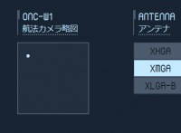
It is possible that the window will show a sphere (or shape model) with a latitude-longitude grid, indicating the orientation of the asteroid in the images (rather than the position of the asteroid), or when closer in, the position of the WA image on the asteroid.
Phil -------------------- ... because the Solar System ain't gonna map itself.
Also to be found posting similar content on https://mastodon.social/@PhilStooke NOTE: everything created by me which I post on UMSF is considered to be in the public domain (NOT CC, public domain) |
 |
 
|
|
Jun 21 2018, 04:31 AM
Post
#347
|
|
|
Member Group: Members Posts: 817 Joined: 17-April 10 From: Kamakura, Japan Member No.: 5323 |
What follows is the translation of the pop-up caption of the display area, to the best of my ability, and as precisely
as possible. "The position and the size of Ryugu as seen by the camera. In the vicinity of Ryugu Hayabusa will be approaching it while capturing Ryugu's external appearance." Position? , why should it matter? Size?, we know it by now. P |
|
|
|
| Guest_mcmcmc_* |
Jun 21 2018, 06:24 AM
Post
#348
|
|
Guests |
Caught!
QUOTE From now on, the asteroid's gravity will dominate the area (Hill area: within about 90 km from the asteroid) will enter! https://twitter.com/haya2_jaxa/status/1009368813429592064 |
|
|
|
|
Jun 21 2018, 07:16 AM
Post
#349
|
||
|
Member Group: Members Posts: 817 Joined: 17-April 10 From: Kamakura, Japan Member No.: 5323 |
Ryugu like thing is now seen in the window we have been talking about!
P
Attached thumbnail(s)
|
|
|
|
|
|
| Guest_mcmcmc_* |
Jun 21 2018, 07:19 AM
Post
#350
|
|
Guests |
QUOTE (Phil Stooke @ Jun 21 2018, 03:38 AM)  It is possible that the window will show a sphere (or shape model) with a latitude-longitude grid, indicating the orientation of the asteroid in the images (rather than the position of the asteroid), or when closer in, the position of the WA image on the asteroid. Phil I think this old PDF explains what is going to happen, although I can't translate it (see p.19): http://fanfun.jaxa.jp/jaxatv/files/20180419_hayabusa2.pdf Probably by "schematic" they mean a 3d model. I think the box will show Hayabusa attitude w.r.t Ryugu during various operations. I whink it will look a lot like a Star Trek Enterprise screen! :-) |
|
|
|
|
Jun 21 2018, 08:01 AM
Post
#351
|
|
|
Member Group: Members Posts: 817 Joined: 17-April 10 From: Kamakura, Japan Member No.: 5323 |
I think information on training will be of interest to forum members. My translation will follow for the few pages
on training as follows. P Page 16: Operation training ・LSS(Landing Site Selection) training Aim: Find out, from technically and scientifically meaningful viewpoint, if our limited resources inluding time can actually land the mother ship and rovers onto the asteroid surface. ・IRIO (Real-time Integrated Operation) training: Use of simulator for landing and proximity operations in critical situation in real time to increase proficiciency of operation members. |
|
|
|
|
Jun 21 2018, 08:30 AM
Post
#352
|
|
|
Member Group: Members Posts: 817 Joined: 17-April 10 From: Kamakura, Japan Member No.: 5323 |
Page 17:
RIO training objectives: We want to increase the operational proficiency of operating members by giving them advance trainings in order to reduce risk and increase success probability in critical mission phase. * Operator training for special phases such as descending towards the ground surface. * Confirming on-site actions in nominal cases in critical operations * Tool operators skill increase in use of tools such as GCP-NAV * Monitoring of contingency cases and reactions * Operators readiness for emergencies * Team integration/building by JAXA and manufacturers members * Verification and confirmation of ground tools 1. Interface confirmation 2. Exracting areas for further improvements in tools GCP-NAV: Ground Control Point Navigation 3. Feedback into real operation 3.1 Identification of improvements in operation manual 3.2 Brushing up of contingency plan in navigation control and guidance GNC: Guidance Navigation and Control P |
|
|
|
|
Jun 21 2018, 09:02 AM
Post
#353
|
|
|
Member Group: Members Posts: 817 Joined: 17-April 10 From: Kamakura, Japan Member No.: 5323 |
Page 18
Types of RIO training A: TRIO(RIO training dry run inside JAXA Franework/contents/date of training * Dry-run 1 (10 times)/ Training within JAXA by making use of hardware simulator(HIL)verification procedures/ January to June 2017 * Dry-run 2 (10 times)/ Training within JAXA by making use of image feedback functions with image generator/ July 2017- May 2018 B: RIO (actual realtime training) Franework/contents/date of training Session 1: October to December 2017 Session 2: January to May 2018 * Small scale training (3 times) Training for GNC related tools in critical operation * Middle scale training (11 times) Training for specific imaginary cases in critical operation * Large scale training (9 times) 24 hour non-stop operation for all major phases in descending operation Total number of training sessions 43. Further 4 trainings are planned before May 2018 (total: 47 training sessions) P |
|
|
|
|
Jun 21 2018, 09:30 AM
Post
#354
|
|
|
Member Group: Members Posts: 817 Joined: 17-April 10 From: Kamakura, Japan Member No.: 5323 |
Having translated this document so far I am no longer sure exactly what they are doing.
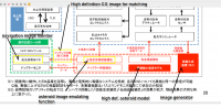
What I can say for sure is that page 19 is dedicated to computer generated imaginary Ryugu pictures called Ryugoroid. Page 20 is a complicated chart and I am not going to spend time on translating it, but I will come to that in a moment after what follows. This is the translation of page 21, most notable statment on that page. Page 21: GCP-NAV: Feedback control from the ground station using generated images. Pre-genarated asteroid model (database of outer shape and specific points) is compared/matched with the real images from Hayabusa, thereby estimating the position of Hayabusa to send control signals. It seems to me that position of Hayabusa is the utmostimportance to JAXA. I do not understand it, but back to page 20's chart. Here at the bottom right is an image generator. Frurther to the left are screens. My current guess is that interactively generated and corrected images (owing to the real images from Hayabusa) are fed into the screen we are watching. So, what we see on the display window may not be the real thing, but very close to real asteroid. What do I mean by that...? P |
|
|
|
| Guest_mcmcmc_* |
Jun 21 2018, 09:55 AM
Post
#355
|
|
Guests |
Your effort is very appreciated, but I presume we'll get the official English version of the PDF within 24 hours, as already happened 2 times.
But I can't find a page listing all the available PDFs, both in english and japanese, does it exist? |
|
|
|
|
Jun 21 2018, 10:00 AM
Post
#356
|
|
|
Member Group: Members Posts: 817 Joined: 17-April 10 From: Kamakura, Japan Member No.: 5323 |
I have annotated parts of the chart on page 20, but unsure if this will go up as it may be a little large.
It represents the simulator. In case it does, the big chunk in green dotted square is the electrical Hayabusa The square at the bottom left contains various monitors, which includes the image monitor they are watching and my guess is that it is the same display monitor that we can watch. Image generator perhaps has a built-in database of the asteroid called Ryugoid, I think. Why cannot they simply show us real images? Is it that difficult to do that? P |
|
|
|
|
Jun 21 2018, 10:02 AM
Post
#357
|
||
|
Member Group: Members Posts: 817 Joined: 17-April 10 From: Kamakura, Japan Member No.: 5323 |
I forgot to upload my annotation.
Yes, its size is just below the limit. P
Attached thumbnail(s)
|
|
|
|
|
|
|
Jun 21 2018, 12:14 PM
Post
#359
|
|
|
Member Group: Members Posts: 817 Joined: 17-April 10 From: Kamakura, Japan Member No.: 5323 |
QUOTE (mcmcmc @ Jun 21 2018, 06:55 PM) Your effort is very appreciated, but I presume we'll get the official English version of the PDF within 24 hours, as already happened 2 times. But I can't find a page listing all the available PDFs, both in english and japanese, does it exist? I am no longer sure about JAXA documents. It seems to me that there are 2 versions of the same (or very similar) documents dated with the same date of 19 April 2018. With one of them (or perhaps both) an English version already exists? 19 April is long time ago... I am also unsure about your question. Do you mean a catalogue of JAXA documents? P |
|
|
|
|
Jun 21 2018, 12:35 PM
Post
#360
|
|
 Senior Member Group: Members Posts: 1729 Joined: 3-August 06 From: 43° 35' 53" N 1° 26' 35" E Member No.: 1004 |
From the images released today, it looks like a more spherical version of Itokawa, but still a remarkable rubble pile with only a few, subdued craters
|
|
|
|
|

|
Lo-Fi Version | Time is now: 19th April 2024 - 02:36 AM |
|
RULES AND GUIDELINES Please read the Forum Rules and Guidelines before posting. IMAGE COPYRIGHT |
OPINIONS AND MODERATION Opinions expressed on UnmannedSpaceflight.com are those of the individual posters and do not necessarily reflect the opinions of UnmannedSpaceflight.com or The Planetary Society. The all-volunteer UnmannedSpaceflight.com moderation team is wholly independent of The Planetary Society. The Planetary Society has no influence over decisions made by the UnmannedSpaceflight.com moderators. |
SUPPORT THE FORUM Unmannedspaceflight.com is funded by the Planetary Society. Please consider supporting our work and many other projects by donating to the Society or becoming a member. |
|