Moon Images By SMART-1 |

  |
Moon Images By SMART-1 |
 Jan 20 2005, 02:45 PM Jan 20 2005, 02:45 PM
Post
#1
|
|
|
Member  Group: Members Posts: 470 Joined: 24-March 04 From: Finland Member No.: 63 |
SMART-1 is approaching its operational orbit. ESA has released some images of the Moon on this page:
http://sci.esa.int/science-e/www/object/in...fobjectid=36358 -------------------- Antti Kuosmanen
|
 |
 
|
|
Jan 27 2005, 02:29 AM
Post
#2
|
|
 Interplanetary Dumpster Diver Group: Admin Posts: 4404 Joined: 17-February 04 From: Powell, TN Member No.: 33 |
More images:
http://www.esa.int/export/SPECIALS/SMART-1...JHDO3E4E_1.html The CCD size seems Clementine-ish. But with less compression and more time to study the moon, the coverage may well be much better. -------------------- |
|
|
|
|
Jan 27 2005, 11:52 PM
Post
#3
|
|
|
Member Group: Members Posts: 295 Joined: 2-March 04 From: Central California Member No.: 45 |
Is it me or does our Moon seem somewhat boring compared to Jupiter and Saturn's oddballs?
Eric P / MizarKey -------------------- Eric P / MizarKey
|
|
|
|
|
Jan 28 2005, 12:20 AM
Post
#4
|
|
|
Interplanetary Dumpster Diver Group: Admin Posts: 4404 Joined: 17-February 04 From: Powell, TN Member No.: 33 |
I am not sure. Some aspects of it seem really interesting...the volcanic domes for instance. I think a lot of it is the old saying "familiarity breeds contempt." The moon is the world we are most used to (other than the Earth). We have had higher resolution images of half of its surface for decades (and if you could seeing as much detail visually for over two centuries) than we have of most of the surfaces of most outer planet satellites. And of course we didn't have "from space" view of earth until half way through this century. So the moon, viewed from above, is the most familar thing to us. I think as a result of this, we think of it as defining normal or ordinary. Really, I can't think of another world like it.
-------------------- |
|
|
|
|
Feb 1 2005, 01:04 AM
Post
#5
|
|
|
Senior Member Group: Members Posts: 1276 Joined: 25-November 04 Member No.: 114 |
What kind of resolution can we expect?
Ranger landers?! |
|
|
|
|
Feb 1 2005, 01:27 AM
Post
#6
|
|
|
Interplanetary Dumpster Diver Group: Admin Posts: 4404 Joined: 17-February 04 From: Powell, TN Member No.: 33 |
"The camera itself has a medium field of view of 5.3 degrees by 5.3 degrees and provides a high-resolution image at 27 metres per pixel from an altitude of 300 kilometres. The image measures 1024 x 1024 pixels. "
-------------------- |
|
|
|
|
Feb 27 2005, 09:21 PM
Post
#7
|
|
|
Junior Member Group: Members Posts: 81 Joined: 25-February 05 From: New Jersey Member No.: 177 |
Overall I have been unimpressed with the resolution of the SMART-1 images. I know an amateur astronomer who is literally taking higher-resolution images from his backyard with a C8.
-------------------- ----------------------------------------------
"Too low they build, who build beneath the stars." - Edward Young |
|
|
|
|
Feb 27 2005, 09:34 PM
Post
#8
|
|
|
Founder Group: Chairman Posts: 14432 Joined: 8-February 04 Member No.: 1 |
QUOTE (MiniTES @ Feb 27 2005, 09:21 PM) Overall I have been unimpressed with the resolution of the SMART-1 images. I know an amateur astronomer who is literally taking higher-resolution images from his backyard with a C8. No one can take 27m/pixel images from their backyard - not even the Keck facility  Doug |
|
|
|
|
Feb 27 2005, 10:02 PM
Post
#9
|
|
|
Junior Member Group: Members Posts: 81 Joined: 25-February 05 From: New Jersey Member No.: 177 |
QUOTE (djellison @ Feb 27 2005, 09:34 PM) QUOTE (MiniTES @ Feb 27 2005, 09:21 PM) Overall I have been unimpressed with the resolution of the SMART-1 images. I know an amateur astronomer who is literally taking higher-resolution images from his backyard with a C8. No one can take 27m/pixel images from their backyard - not even the Keck facility Doug Oops, you're right. What I meant to say was not so much that the actual resolution was higher but just that they look much sharper. This guy processes the heck out of his images and gets resolutions fairly to close to his theoretical maximum. The SMART-1 images just look a bit fuzzy to me. -------------------- ----------------------------------------------
"Too low they build, who build beneath the stars." - Edward Young |
|
|
|
|
Feb 28 2005, 12:11 AM
Post
#10
|
|
|
Interplanetary Dumpster Diver Group: Admin Posts: 4404 Joined: 17-February 04 From: Powell, TN Member No.: 33 |
It may be the use of compression. It has 1024x1024 CCDs, and I have yet to see an image released at that resolution. So it is also possible the releases are degraded, or that these are pre-mapping images that have been binned. Whatever the case, at 27 m/pixel, there should eventually be some spectacular mosaics.
-------------------- |
|
|
|
|
Mar 18 2005, 05:44 PM
Post
#11
|
|
 Member Group: Members Posts: 710 Joined: 28-September 04 Member No.: 99 |
http://sci.esa.int/science-e/www/object/in...fobjectid=36801
"Unfortunately, on starting the calibration program, an anomaly occurred on board. On the night of 28 February the EP engine unexpectedly fired for about 11 hours. The cause was later traced to a recent change in the software and was subsequently corrected. The consequence of this error is a delay in the completion of the instrument lunar commissioning of a couple of weeks. On 12 March, the ESOC Flight dynamics team commanded the spacecraft to perform an equivalent burn to compensate the unintentional one. By the start of April all the instruments should be tested and calibrated and ready to start collecting valuable science data. " Ouch, hopefully this will not shorten the extended mission. |
|
|
|
|
Apr 5 2005, 04:49 AM
Post
#12
|
|
 Senior Member Group: Members Posts: 2492 Joined: 15-January 05 From: center Italy Member No.: 150 |
Anyone know where are promised HR images of LEM sites? SMART should have taken them many weeks ago...
-------------------- I always think before posting! - Marco -
|
|
|
|
|
Apr 5 2005, 07:23 AM
Post
#13
|
|
|
Founder Group: Chairman Posts: 14432 Joined: 8-February 04 Member No.: 1 |
QUOTE (dilo @ Apr 5 2005, 04:49 AM) Anyone know where are promised HR images of LEM sites? SMART should have taken them many weeks ago...  They're not going to occur till it's in it's lowest possible orbit - some months away yet Doug |
|
|
|
|
Apr 5 2005, 09:48 AM
Post
#14
|
|
|
Member Group: Members Posts: 290 Joined: 26-March 04 From: Edam, The Netherlands Member No.: 65 |
QUOTE (djellison @ Apr 5 2005, 07:23 AM) QUOTE (dilo @ Apr 5 2005, 04:49 AM) Anyone know where are promised HR images of LEM sites? SMART should have taken them many weeks ago... They're not going to occur till it's in it's lowest possible orbit - some months away yet Doug How can a LEM be seen on an image with resolution of 27 m / pixel ? It's not 27 meters across is it ? |
|
|
|
|
Apr 5 2005, 10:07 AM
Post
#15
|
|
|
Founder Group: Chairman Posts: 14432 Joined: 8-February 04 Member No.: 1 |
QUOTE (Marcel @ Apr 5 2005, 09:48 AM) QUOTE (djellison @ Apr 5 2005, 07:23 AM) QUOTE (dilo @ Apr 5 2005, 04:49 AM) Anyone know where are promised HR images of LEM sites? SMART should have taken them many weeks ago... They're not going to occur till it's in it's lowest possible orbit - some months away yet Doug How can a LEM be seen on an image with resolution of 27 m / pixel ? It's not 27 meters across is it ? There's something on the ESA website about planned imaging of the sites later, at v.low altitude I believe I thought the same thing as you at first. Doug |
|
|
|
|
Apr 5 2005, 10:10 PM
Post
#16
|
|
|
Senior Member Group: Members Posts: 2492 Joined: 15-January 05 From: center Italy Member No.: 150 |
QUOTE (djellison @ Apr 5 2005, 10:07 AM) QUOTE (Marcel @ Apr 5 2005, 09:48 AM) QUOTE (djellison @ Apr 5 2005, 07:23 AM) QUOTE (dilo @ Apr 5 2005, 04:49 AM) Anyone know where are promised HR images of LEM sites? SMART should have taken them many weeks ago... They're not going to occur till it's in it's lowest possible orbit - some months away yet Doug How can a LEM be seen on an image with resolution of 27 m / pixel ? It's not 27 meters across is it ? There's something on the ESA website about planned imaging of the sites later, at v.low altitude I believe I thought the same thing as you at first. Doug Yes, I'm referring to a press release which mentioned planned pictures of the "landing" sites (I exagerated sayng "LEM" pictures...), some weeks ago. I cannot find the article, but if I recall correctly, images should be already on the ground and should be very interesting... why they publish so few informations??? -------------------- I always think before posting! - Marco -
|
|
|
|
| Guest_Sunspot_* |
Apr 6 2005, 11:11 AM
Post
#17
|
|
Guests |
|
|
|
|
|
Apr 6 2005, 12:28 PM
Post
#18
|
|
|
Member Group: Members Posts: 290 Joined: 26-March 04 From: Edam, The Netherlands Member No.: 65 |
QUOTE (Sunspot @ Apr 6 2005, 11:11 AM) Ah, now i remember. I reread it and the idea is to spot rocket plume disturbance by the lunar module and do it in the same manner as they can do now with MGS (cPROTO: rolling the craft during overpass while keeping the imager on the same target can tripple the resolution in the direction of orbit). I did not know SMART-1 has this (fast and accurate) positioning capabilities though..... A little side step: What would this cPROTO technique mean for MRO-images by the way ? I read that HiRISE has a resolution of about 50 cm/pixel. Would this mean that rolling procedures (enhancing line sampling time) could make images of 15 cm/pixel ? 
|
|
|
|
|
Apr 6 2005, 08:05 PM
Post
#19
|
|
|
Senior Member Group: Members Posts: 2492 Joined: 15-January 05 From: center Italy Member No.: 150 |
QUOTE (Marcel @ Apr 6 2005, 12:28 PM) Ah, now i remember. I reread it and the idea is to spot rocket plume disturbance by the lunar module and do it in the same manner as they can do now with MGS (cPROTO: rolling the craft during overpass while keeping the imager on the same target can tripple the resolution in the direction of orbit). I did not know SMART-1 has this (fast and accurate) positioning capabilities though..... A little side step: What would this cPROTO technique mean for MRO-images by the way ? I read that HiRISE has a resolution of about 50 cm/pixel. Would this mean that rolling procedures (enhancing line sampling time) could make images of 15 cm/pixel ? Hey, 15cm resolution means to have a military spy-satellite around Mars!  Anyway, Marcel, I think that is not necessary to "fast and accurate positioning capabilities" in order to realize this: if you use a CCD detector, it should be sufficient to set correct "timing" for row scanning and this would eliminate effect of spacecraft motion (similar tecnique is used in some automated astronomical telescopes like "spaceguard survey" ones). Anyway, if they really want to portrait LEM vehicles they should fly SMART very low (I calculated a mere 10Km height in order to have 1m resolution!). This is due to relatively wide angle used in the AMIE camera aboard this spacecraft... -------------------- I always think before posting! - Marco -
|
|
|
|
|
Apr 6 2005, 08:20 PM
Post
#20
|
|
|
Founder Group: Chairman Posts: 14432 Joined: 8-February 04 Member No.: 1 |
IIRC - the Smart1 Camera is a discreet 1024 x 1024 pixels, so you couldnt do the cproto type imaging which can only be done with a push-broom single line type of camera.
Doug |
|
|
|
|
Apr 7 2005, 11:00 AM
Post
#21
|
|
|
Member Group: Members Posts: 290 Joined: 26-March 04 From: Edam, The Netherlands Member No.: 65 |
QUOTE (dilo @ Apr 6 2005, 08:05 PM) QUOTE (Marcel @ Apr 6 2005, 12:28 PM) Ah, now i remember. I reread it and the idea is to spot rocket plume disturbance by the lunar module and do it in the same manner as they can do now with MGS (cPROTO: rolling the craft during overpass while keeping the imager on the same target can tripple the resolution in the direction of orbit). I did not know SMART-1 has this (fast and accurate) positioning capabilities though..... A little side step: What would this cPROTO technique mean for MRO-images by the way ? I read that HiRISE has a resolution of about 50 cm/pixel. Would this mean that rolling procedures (enhancing line sampling time) could make images of 15 cm/pixel ? Hey, 15cm resolution means to have a military spy-satellite around Mars! Anyway, Marcel, I think that is not necessary to "fast and accurate positioning capabilities" in order to realize this: if you use a CCD detector, it should be sufficient to set correct "timing" for row scanning and this would eliminate effect of spacecraft motion (similar tecnique is used in some automated astronomical telescopes like "spaceguard survey" ones). Anyway, if they really want to portrait LEM vehicles they should fly SMART very low (I calculated a mere 10Km height in order to have 1m resolution!). This is due to relatively wide angle used in the AMIE camera aboard this spacecraft... 10 km ? Could this be done ? There's no drag, so one could say yes.
|
|
|
|
|
Apr 7 2005, 11:11 AM
Post
#22
|
|
|
Member Group: Members Posts: 290 Joined: 26-March 04 From: Edam, The Netherlands Member No.: 65 |
QUOTE (Marcel @ Apr 7 2005, 11:00 AM) QUOTE (dilo @ Apr 6 2005, 08:05 PM) QUOTE (Marcel @ Apr 6 2005, 12:28 PM) Ah, now i remember. I reread it and the idea is to spot rocket plume disturbance by the lunar module and do it in the same manner as they can do now with MGS (cPROTO: rolling the craft during overpass while keeping the imager on the same target can tripple the resolution in the direction of orbit). I did not know SMART-1 has this (fast and accurate) positioning capabilities though..... A little side step: What would this cPROTO technique mean for MRO-images by the way ? I read that HiRISE has a resolution of about 50 cm/pixel. Would this mean that rolling procedures (enhancing line sampling time) could make images of 15 cm/pixel ? Hey, 15cm resolution means to have a military spy-satellite around Mars! Anyway, Marcel, I think that is not necessary to "fast and accurate positioning capabilities" in order to realize this: if you use a CCD detector, it should be sufficient to set correct "timing" for row scanning and this would eliminate effect of spacecraft motion (similar tecnique is used in some automated astronomical telescopes like "spaceguard survey" ones). Anyway, if they really want to portrait LEM vehicles they should fly SMART very low (I calculated a mere 10Km height in order to have 1m resolution!). This is due to relatively wide angle used in the AMIE camera aboard this spacecraft... 10 km ? Could this be done ? There's no drag, so one could say yes.Found out myself it can be done: apollo 10 came within 9 km's. I'd say do it ! |
|
|
|
|
Apr 7 2005, 11:24 AM
Post
#23
|
|
 Member Group: Members Posts: 255 Joined: 4-January 05 Member No.: 135 |
QUOTE Found out myself it can be done: apollo 10 came within 9 km's. I'd say do it ! IIRC, some of the mountains on the moon are 5-6km high, so you have to dodge if you want to go any lower. Otherwise its no problem at all. |
|
|
|
|
Apr 7 2005, 11:29 AM
Post
#24
|
|
|
Founder Group: Chairman Posts: 14432 Joined: 8-February 04 Member No.: 1 |
Just checked the specs for Amie - and yes - it is a 1024 x 1024 CCD, so the concept of Cproto would not work - the only way to get higher resolution would be to get lower.
MRO could, technically, be commanded to do a motion-compensation technique to get higher than 30cm downrange resolution. How succesfull it would be, I dont know. Frankly - the data output from HiRISE is so enormous - I'm not sure if the supporting electronics would be able to cope, but I'm sure the same was said of MOC before they tried. Doug |
|
|
|
|
Apr 7 2005, 02:30 PM
Post
#25
|
|
|
Interplanetary Dumpster Diver Group: Admin Posts: 4404 Joined: 17-February 04 From: Powell, TN Member No.: 33 |
QUOTE (djellison @ Apr 7 2005, 11:29 AM) Just checked the specs for Amie - and yes - it is a 1024 x 1024 CCD, so the concept of Cproto would not work - the only way to get higher resolution would be to get lower. MRO could, technically, be commanded to do a motion-compensation technique to get higher than 30cm downrange resolution. How succesfull it would be, I dont know. Frankly - the data output from HiRISE is so enormous - I'm not sure if the supporting electronics would be able to cope, but I'm sure the same was said of MOC before they tried. Doug Another problem is that given that MRO won't be circling Mars any slower than MGS, to do CPROTO would result in incredibly short integration times, which might lead to images that are badly underexposed. And I don't know if MRO is stable enough to support such resolution. -------------------- |
|
|
|
|
Apr 7 2005, 02:58 PM
Post
#26
|
|
|
Founder Group: Chairman Posts: 14432 Joined: 8-February 04 Member No.: 1 |
Ah haa...
http://www.msss.com/mer_mission/finding_mer/index.html#PROTO HiRISE will already do it internally QUOTE However, the 2005 Mars Reconnaissance Orbiter (MRO) High Resolution Imaging Science Experiment (HiRISE) experiment is predicated on using internal image motion compensation to provide sampling at smaller scales than its diffraction limit and using image processing techniques to improve the resolution; Doug |
|
|
|
|
Apr 7 2005, 09:37 PM
Post
#27
|
|
 Member Group: Members Posts: 753 Joined: 23-October 04 From: Greensboro, NC USA Member No.: 103 |
The other problem with really low lunar orbit might be the MASCONs - the mass concentrations which had unpredictable effects on orbits of the Lunar Orbiters and Apollo. Were those eventually mapped out well enough that we could ensure that an object in very low lunar orbit would be able to maintain a stable orbit?
-------------------- Jonathan Ward
Manning the LCC at http://www.apollolaunchcontrol.com |
|
|
|
|
Apr 8 2005, 12:12 AM
Post
#28
|
|
 Senior Member Group: Moderator Posts: 2262 Joined: 9-February 04 From: Melbourne - Oz Member No.: 16 |
QUOTE (ilbasso @ Apr 8 2005, 07:37 AM) The other problem with really low lunar orbit might be the MASCONs - the mass concentrations which had unpredictable effects on orbits of the Lunar Orbiters and Apollo. Were those eventually mapped out well enough that we could ensure that an object in very low lunar orbit would be able to maintain a stable orbit? I don't know how well the MASCONs are mapped, but I don't think that really matters as they essentially make any lunar orbit unstable to some degree. I think if they were to ever lower SMART-1 to this kind of altitude it would be end of mission fairly quickly. J. -------------------- |
|
|
|
|
Apr 8 2005, 05:29 AM
Post
#29
|
|
 Senior Member Group: Members Posts: 3419 Joined: 9-February 04 From: Minneapolis, MN, USA Member No.: 15 |
QUOTE (jamescanvin @ Apr 7 2005, 06:12 PM) QUOTE (ilbasso @ Apr 8 2005, 07:37 AM) The other problem with really low lunar orbit might be the MASCONs - the mass concentrations which had unpredictable effects on orbits of the Lunar Orbiters and Apollo. Were those eventually mapped out well enough that we could ensure that an object in very low lunar orbit would be able to maintain a stable orbit? I don't know how well the MASCONs are mapped, but I don't think that really matters as they essentially make any lunar orbit unstable to some degree. I think if they were to ever lower SMART-1 to this kind of altitude it would be end of mission fairly quickly. J. Low lunar orbits can be *very* unstable -- like on the matter of days to weeks. Apollo 15 was inserted into its descent orbit (60 x 9 nmi.) on the second rev after LOI, and roughly 18 hours later the perilune had descended from 50,000 feet to 37,000 feet... and dropping. The 15 crew had to perform a bail-out burn very early on PDI day to increase the perilune before the landing could proceed. Even the "mid-height" lunar orbits that the Apollo CSMs flew weren't all that stable. The Apollo 16 subsatellite was released from the standard CSM orbit (they canceled a shaping burn designed to put the subsatellite into a more stable, somewhat higher orbit), and it fell ou of orbit after only six weeks. The only lunar orbits that are stable over a long period of time are those that are propulsively maintained... *smile*... -the other Doug -------------------- The trouble ain't that there is too many fools, but that the lightning ain't distributed right. -Mark Twain
|
|
|
|
|
Jul 25 2005, 03:02 PM
Post
#30
|
|
|
Member Group: Members Posts: 710 Joined: 28-September 04 Member No.: 99 |
New status update for SMART-1:
http://sci.esa.int/science-e/www/object/in...fobjectid=37703 It will exhaust all its xenon next month! So, no more ion-drive... Also, two new pictures: Glushko crater: http://sci.esa.int/science-e/www/object/in...fobjectid=37704 And Hadley rille: http://sci.esa.int/science-e/www/object/in...fobjectid=37705 |
|
|
|
|
Jul 25 2005, 10:00 PM
Post
#31
|
|
|
Senior Member Group: Members Posts: 2492 Joined: 15-January 05 From: center Italy Member No.: 150 |
Do anyone knows final orbital elements?
-------------------- I always think before posting! - Marco -
|
|
|
|
|
Jul 25 2005, 10:28 PM
Post
#32
|
|
|
Senior Member Group: Members Posts: 2492 Joined: 15-January 05 From: center Italy Member No.: 150 |
QUOTE (dilo @ Jul 25 2005, 10:00 PM) Do anyone knows final orbital elements? Answering by myself..  ..some informations here: ..some informations here:http://sci.esa.int/science-e/www/object/in...fobjectid=36683 It seems that Smart will make an equator/North emisphere high-res coverage... You will find also many other informations, moon eclipse images and a familiar stuff on page 27 of second pdf document ( !)...
-------------------- I always think before posting! - Marco -
|
|
|
|
|
Oct 20 2005, 03:59 PM
Post
#33
|
|
|
Member Group: Members Posts: 295 Joined: 2-March 04 From: Central California Member No.: 45 |
Are there Smart-1 moon images elsewhere besides SMART-1 official images? I count only 7 images of the moon. What's up with that?
Eric P / MizarKey -------------------- Eric P / MizarKey
|
|
|
|
|
Dec 22 2005, 11:06 PM
Post
#34
|
|
 Member Group: Members Posts: 370 Joined: 12-September 05 From: France Member No.: 495 |
SMART-1 uses new imaging technique in lunar orbit
http://www.esa.int/SPECIALS/SMART-1/SEMPID8A9HE_0.html |
|
|
|
|
Dec 23 2005, 05:12 AM
Post
#35
|
|
 Administrator Group: Admin Posts: 5172 Joined: 4-August 05 From: Pasadena, CA, USA, Earth Member No.: 454 |
Well...it's a bit of a stretch to call pushbroom imaging a "new" imaging technique. It's a pretty old technique, even in space -- Mars Global Surveyor has been doing it for many years, and more recently so has Odyssey, and even another ESA spacecraft, Mars Express, right?
--Emily -------------------- My website - My Patreon - @elakdawalla on Twitter - Please support unmannedspaceflight.com by donating here.
|
|
|
|
|
Dec 23 2005, 06:48 AM
Post
#36
|
|
|
Senior Member Group: Members Posts: 2516 Joined: 13-September 05 Member No.: 497 |
QUOTE (elakdawalla @ Dec 22 2005, 09:12 PM) Well...it's a bit of a stretch to call pushbroom imaging a "new" imaging technique. It's a pretty old technique, even in space -- Mars Global Surveyor has been doing it for many years, and more recently so has Odyssey, and even another ESA spacecraft, Mars Express, right? Technically, what they are using is what we call "pushframe" imaging -- they have an area sensor with regions of different colors, and they take an image roughly every band height's advance over the surface. Pushbroom imaging uses a single line array; this is what is used by MOC and MEx. I won't claim to have been the first person to have ever thought of this, but I independently developed it for an unselected Discovery proposal in 1994, and we first used it in a flight instrument for the MARCI on MCO. THEMIS is the first time it was used in Mars orbit, and the MRO MARCI also uses it, as will the Wide Angle Camera on LRO. Typical ESA press release. -------------------- Disclaimer: This post is based on public information only. Any opinions are my own.
|
|
|
|
|
Dec 23 2005, 09:29 PM
Post
#37
|
|
|
Solar System Cartographer Group: Members Posts: 10160 Joined: 5-April 05 From: Canada Member No.: 227 |
Emily said (quite correctly):
"Well...it's a bit of a stretch to call pushbroom imaging a "new" imaging technique. " True - but they did add "never used before in lunar orbit" or words to that effect. Which I presume is true. Phil -------------------- ... because the Solar System ain't gonna map itself.
Also to be found posting similar content on https://mastodon.social/@PhilStooke Maps for download (free PD: https://upload.wikimedia.org/wikipedia/comm...Cartography.pdf NOTE: everything created by me which I post on UMSF is considered to be in the public domain (NOT CC, public domain) |
|
|
|
|
Dec 24 2005, 12:02 AM
Post
#38
|
|
|
Member Group: Members Posts: 163 Joined: 16-March 05 From: Oakville, Ontario, Canada Member No.: 201 |
|
|
|
|
|
Dec 27 2005, 05:44 PM
Post
#39
|
|
|
Solar System Cartographer Group: Members Posts: 10160 Joined: 5-April 05 From: Canada Member No.: 227 |
Preliminary impact data including a site - on the far side, but they say it might be changed so they can monitor it.
Phil Perilune of 0 km * Date = 2006/08/17 ~11:00 (uncertainty ~ 1 day) * Radius of perilune = 1738 km * Radius of apolune = 5096 km * Inclination = 91.4° * Right ascension of ascending node = 239.7° * Argument of perilune = 217.5° * Sun-moon-perilune angle = 87.0° * Earth-moon-perilune angle = 134.4° * Longitude of perilune = 174.4° * Latitude of perilune = -37.5° * +X to Earth angle when +Z to velocity at perilune = 105.0° * Velocity at perilune = 2.051 km/s * Perilune radius change per orbit -1.888 km/rev It should be noted that the impact date of 17 August 2006 assumes no further changes are made to the spacecraft orbit. It is possible that this date will change to accomodate specific requests to enable monitoring of the impact from Earth. -------------------- ... because the Solar System ain't gonna map itself.
Also to be found posting similar content on https://mastodon.social/@PhilStooke Maps for download (free PD: https://upload.wikimedia.org/wikipedia/comm...Cartography.pdf NOTE: everything created by me which I post on UMSF is considered to be in the public domain (NOT CC, public domain) |
|
|
|
|
Dec 27 2005, 06:53 PM
Post
#40
|
|
 Senior Member Group: Members Posts: 2488 Joined: 17-April 05 From: Glasgow, Scotland, UK Member No.: 239 |
I, too, thought that the ESA Press Release was a classic bit of ESA-Speak, but as Phil points out it was - strictly - true. Well, apart from the 'push-frame' vs 'push-broom' question, anyway! I wonder when, if SMART-1 reaches a perilune of 0km in mid 2006, ESA will actually announce EOM? 2007? Perhaps they'll claim a new record for *surface* push-broom operations... ...it's said to be quite dusty down there!
On a less silly note, I'm intrigued by the commencement of this new imaging mode at what is by any standards a late stage of the mission. Reading the ESA PR, it looks to me like push-broom/frame is actually quite hard on the imaging system - am I right in this? Bob Shaw -------------------- Remember: Time Flies like the wind - but Fruit Flies like bananas!
|
|
|
|
|
Jan 1 2006, 08:15 PM
Post
#41
|
|
|
Solar System Cartographer Group: Members Posts: 10160 Joined: 5-April 05 From: Canada Member No.: 227 |
Update to the SMART-1 end of mision post: the longitude is ambiguous, but I checked with the phase angle data and it must be 174.4 degrees east, not west.
Phil -------------------- ... because the Solar System ain't gonna map itself.
Also to be found posting similar content on https://mastodon.social/@PhilStooke Maps for download (free PD: https://upload.wikimedia.org/wikipedia/comm...Cartography.pdf NOTE: everything created by me which I post on UMSF is considered to be in the public domain (NOT CC, public domain) |
|
|
|
|
Jan 26 2006, 05:26 AM
Post
#42
|
|
|
Senior Member Group: Members Posts: 2454 Joined: 8-July 05 From: NGC 5907 Member No.: 430 |
SMART-1 approach to lunar polar orbit, November 2004
http://www.svengrahn.pp.se/histind/smart/smartatmoon.html -------------------- "After having some business dealings with men, I am occasionally chagrined,
and feel as if I had done some wrong, and it is hard to forget the ugly circumstance. I see that such intercourse long continued would make one thoroughly prosaic, hard, and coarse. But the longest intercourse with Nature, though in her rudest moods, does not thus harden and make coarse. A hard, sensible man whom we liken to a rock is indeed much harder than a rock. From hard, coarse, insensible men with whom I have no sympathy, I go to commune with the rocks, whose hearts are comparatively soft." - Henry David Thoreau, November 15, 1853 |
|
|
|
|
Feb 16 2006, 10:10 PM
Post
#43
|
|
|
Solar System Cartographer Group: Members Posts: 10160 Joined: 5-April 05 From: Canada Member No.: 227 |
-------------------- ... because the Solar System ain't gonna map itself.
Also to be found posting similar content on https://mastodon.social/@PhilStooke Maps for download (free PD: https://upload.wikimedia.org/wikipedia/comm...Cartography.pdf NOTE: everything created by me which I post on UMSF is considered to be in the public domain (NOT CC, public domain) |
|
|
|
|
Mar 3 2006, 01:42 PM
Post
#44
|
|
|
Solar System Cartographer Group: Members Posts: 10160 Joined: 5-April 05 From: Canada Member No.: 227 |
Another new image...
http://www.esa.int/SPECIALS/SMART-1/index.html They are being released at a breathtaking pace these days - assuming you breathe cautiously. I actually emailed Josset at Space-X to point out that people thought SMART-1 was doing nothing because there were no releases. No reply. But we are getting pictures more frequently. Phil -------------------- ... because the Solar System ain't gonna map itself.
Also to be found posting similar content on https://mastodon.social/@PhilStooke Maps for download (free PD: https://upload.wikimedia.org/wikipedia/comm...Cartography.pdf NOTE: everything created by me which I post on UMSF is considered to be in the public domain (NOT CC, public domain) |
|
|
|
|
Mar 3 2006, 03:42 PM
Post
#45
|
|
|
Senior Member Group: Members Posts: 2488 Joined: 17-April 05 From: Glasgow, Scotland, UK Member No.: 239 |
QUOTE (Phil Stooke @ Mar 3 2006, 01:42 PM) Another new image... http://www.esa.int/SPECIALS/SMART-1/index.html They are being released at a breathtaking pace these days - assuming you breathe cautiously. I actually emailed Josset at Space-X to point out that people thought SMART-1 was doing nothing because there were no releases. No reply. But we are getting pictures more frequently. Phil Phil: Breathing cautiously? Breathing bi-monthly, maybe... ...it all leads my cynical little mind to wonder if it's because the rest of the images are simply too poor quality-wise for ESA to admit to! Bob Shaw -------------------- Remember: Time Flies like the wind - but Fruit Flies like bananas!
|
|
|
|
| Guest_BruceMoomaw_* |
Mar 3 2006, 09:13 PM
Post
#46
|
|
Guests |
I kind of doubt that. The thing to keep in mind about SMART-1 is that it's really quite a high-altitude lunar orbiter, and its camera's lens is quite small. All its photos were bound to be wide-angle, low-resolution shots that really didn't show us anything we haven't seen before. (It is, after all, an engineering test mission; its science output is optional.) I've always thought that the really interesting data from it will all come from its near-IR and X-ray spectrometers -- the former has never been done from lunar orbit at all, and the latter has never been done from a polar orbit.
When push comes to shove, when the ESA launches something, it usually works. |
|
|
|
|
Mar 7 2006, 12:36 PM
Post
#47
|
|
|
Member Group: Members Posts: 370 Joined: 12-September 05 From: France Member No.: 495 |
http://space.com/missionlaunches/060307_smart1_moon.html
Engineers and scientists are now targeting SMART-1 for possible impact on the Moon around September 1-2. The current uncertainty range for the exact time of impact is 15 hours. At the end of June, SMART-1 is slated to carry out two maneuvers. These will fine-tune the exact time of impact. Those slight thrust firings will lead to the spacecraft flying over the Moon at its lowest point at below186 miles (300 kilometers) in altitude. In early August, SMART-1 will make an overflight of its eventual impact site, racing over that area at just 75 miles (120 kilometers) height in whats termed as rehearsal mode for the early September run-in with the Moon. A current orbit simulation of the SMART-1 impact for September 2 is at lunar longitude 44.54 degrees West and 36.22 South in Lacus Excellentiae, 10 degrees south of Mare Humorum. A far more refined target point will come as the event draws closer. Impact observations would include: Infrared imaging of thermal flash; visible/infrared imaging of ejected clouds; hydrazine flame detection; post-characterization of ejecta; as well as exospheric effects if lunar material is blasted high off the Moons surface. In addition there is also intent to conduct follow up searches for the crater produced by SMART-1s crash into the Moon via the sensor eyes of future, follow-on lunar orbiters. |
|
|
|
|
Mar 7 2006, 04:26 PM
Post
#48
|
|
|
Interplanetary Dumpster Diver Group: Admin Posts: 4404 Joined: 17-February 04 From: Powell, TN Member No.: 33 |
I wonder if will give us a Ranger-like sequence...I don't know anything about Smart-1's transmission capabilities, so I don't know if this is even possible. But I sure hope it is!
-------------------- |
|
|
|
|
Mar 7 2006, 04:46 PM
Post
#49
|
|
|
Senior Member Group: Members Posts: 2488 Joined: 17-April 05 From: Glasgow, Scotland, UK Member No.: 239 |
QUOTE (tedstryk @ Mar 7 2006, 04:26 PM) I wonder if will give us a Ranger-like sequence...I don't know anything about Smart-1's transmission capabilities, so I don't know if this is even possible. But I sure hope it is! Oh yes, it will transmit one picture every 2.5 seconds as it descends, for nearly 12 minutes. Trouble is, ESA will then release them at the rate of one picture a month, over a period of about 15 years. Cheers, ESA! Bob Shaw -------------------- Remember: Time Flies like the wind - but Fruit Flies like bananas!
|
|
|
|
|
Mar 7 2006, 05:33 PM
Post
#50
|
|
|
Solar System Cartographer Group: Members Posts: 10160 Joined: 5-April 05 From: Canada Member No.: 227 |
That's a relief! I found Ranger 9 way too traumatic.
Phil -------------------- ... because the Solar System ain't gonna map itself.
Also to be found posting similar content on https://mastodon.social/@PhilStooke Maps for download (free PD: https://upload.wikimedia.org/wikipedia/comm...Cartography.pdf NOTE: everything created by me which I post on UMSF is considered to be in the public domain (NOT CC, public domain) |
|
|
|
|
Mar 7 2006, 09:39 PM
Post
#51
|
|
|
Senior Member Group: Members Posts: 3419 Joined: 9-February 04 From: Minneapolis, MN, USA Member No.: 15 |
And don't forget, ESA will claim in every picture they release that they have made the exciting new discovery that the Moon's craters get smaller and smaller as you get closer and closer...
 -the other Doug -------------------- The trouble ain't that there is too many fools, but that the lightning ain't distributed right. -Mark Twain
|
|
|
|
|
Mar 7 2006, 10:21 PM
Post
#52
|
|
|
Senior Member Group: Members Posts: 2488 Joined: 17-April 05 From: Glasgow, Scotland, UK Member No.: 239 |
QUOTE (dvandorn @ Mar 7 2006, 09:39 PM) And don't forget, ESA will claim in every picture they release that they have made the exciting new discovery that the Moon's craters get smaller and smaller as you get closer and closer... -the other Doug oDougal: No, no, *these* craters are big, but far away. And *those* craters are small, but close by. Yes, Mrs Doyle, what is it? Bob Shaw -------------------- Remember: Time Flies like the wind - but Fruit Flies like bananas!
|
|
|
|
|
Mar 7 2006, 10:34 PM
Post
#53
|
|
|
Founder Group: Chairman Posts: 14432 Joined: 8-February 04 Member No.: 1 |
I don't think I've visited a forum where "small.....faaaaar away" hasn't come up at least twice. Fundamentally, it's the reason I set this place up, so I could have further excuses to quote Python and Father Ted
Doug |
|
|
|
|
Mar 9 2006, 05:34 PM
Post
#54
|
|
|
Solar System Cartographer Group: Members Posts: 10160 Joined: 5-April 05 From: Canada Member No.: 227 |
Yet another SMART-1 image - actually a mosaic -at:
http://sci.esa.int/science-e/www/object/in...fobjectid=38921 Phil -------------------- ... because the Solar System ain't gonna map itself.
Also to be found posting similar content on https://mastodon.social/@PhilStooke Maps for download (free PD: https://upload.wikimedia.org/wikipedia/comm...Cartography.pdf NOTE: everything created by me which I post on UMSF is considered to be in the public domain (NOT CC, public domain) |
|
|
|
|
Mar 9 2006, 08:22 PM
Post
#55
|
|
|
Senior Member Group: Members Posts: 2488 Joined: 17-April 05 From: Glasgow, Scotland, UK Member No.: 239 |
Oh! All Praise Blessed ESA!
We, your humble taxpayers, thank you for the signal boon of yet another four glorious images, miraculously transformed into a never-before-imagined mosaic of stunning and unmatched quality! We are not worthy! We are not worthy! Bob Shaw -------------------- Remember: Time Flies like the wind - but Fruit Flies like bananas!
|
|
|
|
|
Mar 22 2006, 12:43 PM
Post
#56
|
|
|
Member Group: Members Posts: 370 Joined: 12-September 05 From: France Member No.: 495 |
New image today.
Tectonic wrinkles in Crater De Gasparis http://www.esa.int/SPECIALS/SMART-1/SEME93OVGJE_0.html |
|
|
|
|
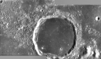
Mar 23 2006, 02:12 PM
Post
#57
|
||
|
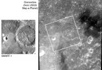
Solar System Cartographer Group: Members Posts: 10160 Joined: 5-April 05 From: Canada Member No.: 227 |
This image is a comparison of SMART-1 and Clementine to show the differences in resolution and illumination. The large crater is De Gasparis, the most recent released image. I'm not sure if we will have global coverage like this, but it will be a very nice dataset when it is eventually released. As I understand it, global coverage from LRO will not be significantly better than this. Only small areas will be seen at very high resolution by LRO, like MOC at Mars.
Phil
-------------------- ... because the Solar System ain't gonna map itself.
Also to be found posting similar content on https://mastodon.social/@PhilStooke Maps for download (free PD: https://upload.wikimedia.org/wikipedia/comm...Cartography.pdf NOTE: everything created by me which I post on UMSF is considered to be in the public domain (NOT CC, public domain) |
|
|
|
|
|
|
Mar 23 2006, 08:31 PM
Post
#58
|
|
|
Solar System Cartographer Group: Members Posts: 10160 Joined: 5-April 05 From: Canada Member No.: 227 |
-------------------- ... because the Solar System ain't gonna map itself.
Also to be found posting similar content on https://mastodon.social/@PhilStooke Maps for download (free PD: https://upload.wikimedia.org/wikipedia/comm...Cartography.pdf NOTE: everything created by me which I post on UMSF is considered to be in the public domain (NOT CC, public domain) |
|
|
|
|
Mar 24 2006, 10:03 AM
Post
#59
|
||||
|
Senior Member Group: Members Posts: 2488 Joined: 17-April 05 From: Glasgow, Scotland, UK Member No.: 239 |
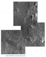
And here are the images which Phil pointed us at:
Bob Shaw
Attached thumbnail(s)
-------------------- Remember: Time Flies like the wind - but Fruit Flies like bananas!
|
|||
|
|
|
|||
|
Apr 1 2006, 08:22 PM
Post
#60
|
|
|
Member Group: Members Posts: 370 Joined: 12-September 05 From: France Member No.: 495 |
SMART-1 performed a tracking observation on Reiner Gamma
http://smart.esa.int/science-e/www/object/...fobjectid=39022 |
|
|
|
|
Apr 1 2006, 08:34 PM
Post
#61
|
|
|
Senior Member Group: Members Posts: 2492 Joined: 15-January 05 From: center Italy Member No.: 150 |
QUOTE (Rakhir @ Apr 1 2006, 08:22 PM) SMART-1 performed a tracking observation on Reiner Gamma http://smart.esa.int/science-e/www/object/...fobjectid=39022 Very interesting: "The area also coincides with a strong magnetic anomaly." Should we go to check if a monolith wait for us?
-------------------- I always think before posting! - Marco -
|
|
|
|
|
Apr 1 2006, 08:53 PM
Post
#62
|
|
|
Newbie Group: Members Posts: 6 Joined: 19-July 05 Member No.: 441 |
Very cool. What's the little dark spot in the bottom right corner that moves "up" during the animation?
|
|
|
|
| Guest_BruceMoomaw_* |
Apr 1 2006, 09:08 PM
Post
#63
|
|
Guests |
That's the UFO taking off from the secret underground landing facility, of course. Richard Hoagland will tell you all about it, once he gets back from his weekend in the 6th dimension.
|
|
|
|
|
Apr 1 2006, 09:26 PM
Post
#64
|
|
|
Senior Member Group: Members Posts: 2488 Joined: 17-April 05 From: Glasgow, Scotland, UK Member No.: 239 |
QUOTE (Rakhir @ Apr 1 2006, 09:22 PM) SMART-1 performed a tracking observation on Reiner Gamma http://smart.esa.int/science-e/www/object/...fobjectid=39022 The ESA web page mentions that, apart from Reiner Gamma, there are two other anomalous swirl features on the Moon. I only knew of RG - anyone know which the others are? QUOTE (BruceMoomaw @ Apr 1 2006, 10:08 PM) That's the U*O taking off from the s*c*et un*ergr*u*d l*nd*ng f*cility, of course. R*c*ard H*a*l*nd will tell you all about it, once he gets back from his weekend in the 6th dimension. Bruce: No! No! You'll bring them here! Quick, read this sign! Bob Shaw
Attached image(s)
-------------------- Remember: Time Flies like the wind - but Fruit Flies like bananas!
|
|
|
|
|
Apr 1 2006, 09:56 PM
Post
#65
|
|
|
Solar System Cartographer Group: Members Posts: 10160 Joined: 5-April 05 From: Canada Member No.: 227 |
The other two swirl areas are more distributed arrangements of smaller bright swirls, lacking a single feature as large and contrasty as Reiner Gamma itself. Also they are not in such open mare areas, so less visible against a rougher background.
One is in the Mare Marginis area roughly antipodal to Orientale. The second is in the Mare Ingenii area on the far side, roughly antipodal to the Imbrium basin. The antipodal arrangement is possibly related to their origin. One suggested mechanism is as follows: a large impact creates a large ejecta plume which spreads out in all directions. Eventually it closes on itself around the antipodal point. The ejecta thus is somewhat concentrated at the antipodal point. That ejecta traps the magnetic field associated with the solar wind (or maybe the contemporary lunar field) causing a magnetic anomaly. The swirls are associated with both the ejecta and the magnetic anomaly. I don't pretend to understand the mechanism in detail. The spot is a flaw in the CCD (or similar artifact). It's really at the same pixel location in every image. Phil -------------------- ... because the Solar System ain't gonna map itself.
Also to be found posting similar content on https://mastodon.social/@PhilStooke Maps for download (free PD: https://upload.wikimedia.org/wikipedia/comm...Cartography.pdf NOTE: everything created by me which I post on UMSF is considered to be in the public domain (NOT CC, public domain) |
|
|
|
|
Apr 1 2006, 10:14 PM
Post
#66
|
|
|
Senior Member Group: Members Posts: 2488 Joined: 17-April 05 From: Glasgow, Scotland, UK Member No.: 239 |
Phil:
Thanks for that. Any idea whether there have been searches at other - eg farside - antipodes to big impacts? Bob Shaw -------------------- Remember: Time Flies like the wind - but Fruit Flies like bananas!
|
|
|
|
| Guest_BruceMoomaw_* |
Apr 2 2006, 05:04 AM
Post
#67
|
|
Guests |
QUOTE (Bob Shaw @ Apr 1 2006, 09:26 PM) Bruce: No! No! You'll bring them here! Quick, read this sign! Bob Shaw Won't work any more, Bob. Had you continued to read the comics, you'd know that Mxy dropped that rule back around 1988 -- now he leaves when he damn well feels like it, and not before. (Even he has some limits, though, so I'll refrain from my initial plan to repeat H******d's name three more times in this message.) |
|
|
|
|
Apr 3 2006, 02:22 AM
Post
#68
|
|
|
Solar System Cartographer Group: Members Posts: 10160 Joined: 5-April 05 From: Canada Member No.: 227 |
Bob, regarding other possible antipodal swirls: I'm sure they have been searched for, but the pre-Clementine images would have been limited in quality and I'm not up to date with what's been done with Clementine. If they really are associated with ejecta, older swirls associated with some other basins would likely have been destroyed by later impacts. For instance, putative Crisium swirls would be destroyed by the Orientale impact.
Also, if this is the explanation, what produced Reiner Gamma? Still not at all clear. Phil -------------------- ... because the Solar System ain't gonna map itself.
Also to be found posting similar content on https://mastodon.social/@PhilStooke Maps for download (free PD: https://upload.wikimedia.org/wikipedia/comm...Cartography.pdf NOTE: everything created by me which I post on UMSF is considered to be in the public domain (NOT CC, public domain) |
|
|
|
|
Apr 6 2006, 03:31 PM
Post
#69
|
|
|
Senior Member Group: Members Posts: 2454 Joined: 8-July 05 From: NGC 5907 Member No.: 430 |
Reiner Gamma swirl: magnetic effect of a cometary impact?
This animation, made from images taken by the Advanced Moon Imaging Experiment (AMIE) on board ESAs SMART-1 spacecraft, shows a feature characterized by bright albedo, and called Reiner Gamma Formation. Read more: http://www.esa.int/esaSC/SEM05FNFGLE_index_0.html -------------------- "After having some business dealings with men, I am occasionally chagrined,
and feel as if I had done some wrong, and it is hard to forget the ugly circumstance. I see that such intercourse long continued would make one thoroughly prosaic, hard, and coarse. But the longest intercourse with Nature, though in her rudest moods, does not thus harden and make coarse. A hard, sensible man whom we liken to a rock is indeed much harder than a rock. From hard, coarse, insensible men with whom I have no sympathy, I go to commune with the rocks, whose hearts are comparatively soft." - Henry David Thoreau, November 15, 1853 |
|
|
|
|
Apr 6 2006, 08:41 PM
Post
#70
|
|
|
Senior Member Group: Members Posts: 1636 Joined: 9-May 05 From: Lima, Peru Member No.: 385 |
Interesting ljk-4 article.
So, the Reiner Gamma Formation could be an interesting site for future human exploration because of the radiation deflected from the surface. Further testing of this hypothesis requires access to the physical properties of the surface to constrain the mechanisms of formation of the lunar swirls. This is an ongoing task for the AMIE camera, aimed at studying regolith photometric properties. This will lead as a possiblity place to set up a moon base since that zone might have deflaction properties of solar radiation. What else can be explained of the bright spots of Moon surface since Moon has no aeolian force to clean the dirty surface and the only possibility is of the magnetic field. This means that the sun radiation is getting dirtier to moon surface....So this must be a interesting hypothesis and it is worth to be confirmed. Rodolfo |
|
|
|
|
Apr 6 2006, 09:56 PM
Post
#71
|
|
|
Senior Member Group: Members Posts: 2488 Joined: 17-April 05 From: Glasgow, Scotland, UK Member No.: 239 |
Rodolfo:
I don't think there's any evidence for current deflection of debris or interference with radiation etc - what we see is a snapshot in time. Bob Shaw -------------------- Remember: Time Flies like the wind - but Fruit Flies like bananas!
|
|
|
|
|
Apr 9 2006, 04:42 AM
Post
#72
|
|
|
Senior Member Group: Members Posts: 1636 Joined: 9-May 05 From: Lima, Peru Member No.: 385 |
QUOTE (Bob Shaw @ Apr 6 2006, 04:56 PM) I don't think there's any evidence for current deflection of debris or interference with radiation etc - what we see is a snapshot in time. I have enclosed an article from: http://www.universetoday.com/am/publish/re...irl.html?742006 So, it was suggested that the Reiner Gamma swirls correspond to magnetised materials in the crust or iron-rich ejecta materials able to deflect the solar wind (constant flow of charged particles coming from the Sun). This would prevent surface materials to undergo maturation processes, and so produce an optical anomaly. So, the Reiner Gamma Formation could be an interesting site for future human exploration because of the radiation deflected from the surface. Further testing of this hypothesis requires access to the physical properties of the surface to constrain the mechanisms of formation of the lunar swirls. This is an ongoing task for the AMIE camera, aimed at studying regolith photometric properties. However, this case is still an hypothesis, it might be of others factors such as : Then, the magnetic anomaly would not be the result of an antipodal crustal field generated in the formation process of large impact basins. It would rather arise from local effects during the interaction between the lunar surface and cometary physical environment, with the possibility that the solar wind is locally deflected and contributes to the unusual optical properties. Phil, do you think that these sites are worth to be explored by any surface robot? What kind of scientific instrument is needed to confirm that hypothesis? An magnetometer? Rodolfo |
|
|
|
|
Apr 9 2006, 04:52 AM
Post
#73
|
|
|
Solar System Cartographer Group: Members Posts: 10160 Joined: 5-April 05 From: Canada Member No.: 227 |
Magnetic mapping from orbit is never at very high resolution. It would be scientifically useful to run surface traverses across Reiner Gamma with a magnetometer - on a robotic or crewed rover.
Phil -------------------- ... because the Solar System ain't gonna map itself.
Also to be found posting similar content on https://mastodon.social/@PhilStooke Maps for download (free PD: https://upload.wikimedia.org/wikipedia/comm...Cartography.pdf NOTE: everything created by me which I post on UMSF is considered to be in the public domain (NOT CC, public domain) |
|
|
|
|
Apr 27 2006, 07:01 AM
Post
#74
|
|
|
Member Group: Members Posts: 295 Joined: 2-March 04 From: Central California Member No.: 45 |
Latest image posted...http://esamultimedia.esa.int/images/smart_...um_comp_new.jpg
That brings the total images from SMART-1 of the moon on the official site to 16. Woo hoo. Is there a better site with more SMART-1 images than the official site? I googled for about 1/2 hour but didn't find another site with more images. Any ideas on the total number of images taken by SMART-1? -------------------- Eric P / MizarKey
|
|
|
|
|
Apr 27 2006, 08:44 AM
Post
#75
|
|
|
Senior Member Group: Members Posts: 2492 Joined: 15-January 05 From: center Italy Member No.: 150 |
Not to mention the poor images quality...
-------------------- I always think before posting! - Marco -
|
|
|
|
|
Apr 27 2006, 08:02 PM
Post
#76
|
|
|
Senior Member Group: Members Posts: 2488 Joined: 17-April 05 From: Glasgow, Scotland, UK Member No.: 239 |
QUOTE (MizarKey @ Apr 27 2006, 08:01 AM) Any ideas on the total number of images taken by SMART-1? I have the impression it's many tens of thousands. Pathetic, eh? Bob Shaw -------------------- Remember: Time Flies like the wind - but Fruit Flies like bananas!
|
|
|
|
|
May 3 2006, 08:58 PM
Post
#77
|
|
|
Member Group: Members Posts: 370 Joined: 12-September 05 From: France Member No.: 495 |
New image.
SMART-1s view of Crater Hopmann: on the shoulder of a giant http://www.esa.int/esaSC/SEM1PPOFGLE_index_0.html |
|
|
|
|
May 15 2006, 12:26 PM
Post
#78
|
|
|
Junior Member Group: Members Posts: 72 Joined: 22-December 05 Member No.: 616 |
Great mission which doesn't get much attantion in my opinion!
http://www.esa.int/SPECIALS/SMART-1/SEM1PPOFGLE_0.html |
|
|
|
|
May 15 2006, 01:31 PM
Post
#79
|
|
|
Interplanetary Dumpster Diver Group: Admin Posts: 4404 Joined: 17-February 04 From: Powell, TN Member No.: 33 |
QUOTE (Steffen @ May 15 2006, 12:26 PM) Great mission which doesn't get much attantion in my opinion! http://www.esa.int/SPECIALS/SMART-1/SEM1PPOFGLE_0.html It is due to the lack of press releases compared to other missions. It may be doing great science, but we have no way to knowwhat it is finding. I predict that when global multispectral mosaics are compiled and released, there will be much more discussion. -------------------- |
|
|
|
|
May 15 2006, 01:39 PM
Post
#80
|
|
|
Senior Member Group: Members Posts: 2488 Joined: 17-April 05 From: Glasgow, Scotland, UK Member No.: 239 |
QUOTE (tedstryk @ May 15 2006, 02:31 PM) It is due to the lack of press releases compared to other missions. It may be doing great science, but we have no way to knowwhat it is finding. I predict that when global multispectral mosaics are compiled and released, there will be much more discussion. Yes, but they'll release them in 2038 at this rate! Bob Shaw -------------------- Remember: Time Flies like the wind - but Fruit Flies like bananas!
|
|
|
|
|
May 15 2006, 01:41 PM
Post
#81
|
|
 Senior Member Group: Members Posts: 3648 Joined: 1-October 05 From: Croatia Member No.: 523 |
QUOTE (Bob Shaw @ May 15 2006, 02:39 PM) Yes, but they'll release them in 2038 at this rate! Look on the bright side: by that time, they'll be able to do wonders in data processing of the acquired imagery!
-------------------- |
|
|
|
|
Jun 1 2006, 07:20 PM
Post
#82
|
|
|
Senior Member Group: Members Posts: 2454 Joined: 8-July 05 From: NGC 5907 Member No.: 430 |
These two images, taken by the advanced Moon Imaging Experiment (AMIE) on board
ESAs SMART-1 spacecraft, show the difference between lunar highlands and a mare area from close by. Full story: http://www.esa.int/esaSC/SEMGBM9ATME_index_0.html -------------------- "After having some business dealings with men, I am occasionally chagrined,
and feel as if I had done some wrong, and it is hard to forget the ugly circumstance. I see that such intercourse long continued would make one thoroughly prosaic, hard, and coarse. But the longest intercourse with Nature, though in her rudest moods, does not thus harden and make coarse. A hard, sensible man whom we liken to a rock is indeed much harder than a rock. From hard, coarse, insensible men with whom I have no sympathy, I go to commune with the rocks, whose hearts are comparatively soft." - Henry David Thoreau, November 15, 1853 |
|
|
|
|
Jun 2 2006, 03:00 AM
Post
#83
|
|
 Senior Member Group: Members Posts: 2530 Joined: 20-April 05 Member No.: 321 |
QUOTE (Bob Shaw @ Mar 9 2006, 01:22 PM) Oh! All Praise Blessed ESA! We, your humble taxpayers, thank you for the signal boon of yet another four glorious images, miraculously transformed into a never-before-imagined mosaic of stunning and unmatched quality! We are not worthy! We are not worthy! Bob Shaw You forgot to add that the subject of this rare imagery is the faraway and hitherto unknown orb called Moon. |
|
|
|
|
Jun 2 2006, 08:32 AM
Post
#84
|
|
 Member Group: Members Posts: 593 Joined: 20-April 05 Member No.: 279 |
QUOTE (ljk4-1 @ Jun 1 2006, 08:20 PM) These two images, taken by the advanced Moon Imaging Experiment (AMIE) on board ESAs SMART-1 spacecraft, show the difference between lunar highlands and a mare area from close by. That's an official release? That the Moon actually has (get this!!) dark and light areas? Perhaps, in a week or so, when the Moon is a bit fuller, we could all go outside one night and confirm this remarkable ESA fact? Hopefully SMART-1 will be followed by EXTREMELYINTELLIGENTINDEED-2. Andy G |
|
|
|
|
Jun 2 2006, 09:10 AM
Post
#85
|
|
|
Senior Member Group: Members Posts: 3648 Joined: 1-October 05 From: Croatia Member No.: 523 |
QUOTE (AndyG @ Jun 2 2006, 09:32 AM) That's an official release? That the Moon actually has (get this!!) dark and light areas? Perhaps, in a week or so, when the Moon is a bit fuller, we could all go outside one night and confirm this remarkable ESA fact? I fail to see where in the press release it is they claim credit for "discovering" the dark and light areas so what's all the fuss about? Seems to me that it's fashionable now to bash SMART-1 press release frequency so everybody feels to need to jump on this wagon. I have a better candidate -- why don't we attack, for example, the VIMS instrument' s team aboard Cassini instead? I don't see all too many releases from an instrument that supposedly has better visibility through Titan's haze than ISS, but that doesn't seem to bother anyone. Not fashionable enough, I guess... -------------------- |
|
|
|
|
Jun 2 2006, 11:32 AM
Post
#86
|
|
|
Senior Member Group: Members Posts: 2454 Joined: 8-July 05 From: NGC 5907 Member No.: 430 |
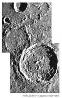
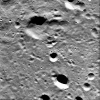
This image, taken by the advanced Moon Imaging Experiment (AMIE) on board
ESA's SMART-1 spacecraft, shows the central peaks of crater Zucchius. Full story: http://www.esa.int/esaSC/SEMVQM9ATME_index_0.html -------------------- "After having some business dealings with men, I am occasionally chagrined,
and feel as if I had done some wrong, and it is hard to forget the ugly circumstance. I see that such intercourse long continued would make one thoroughly prosaic, hard, and coarse. But the longest intercourse with Nature, though in her rudest moods, does not thus harden and make coarse. A hard, sensible man whom we liken to a rock is indeed much harder than a rock. From hard, coarse, insensible men with whom I have no sympathy, I go to commune with the rocks, whose hearts are comparatively soft." - Henry David Thoreau, November 15, 1853 |
|
|
|
|
Jun 2 2006, 12:39 PM
Post
#87
|
|
|
Solar System Cartographer Group: Members Posts: 10160 Joined: 5-April 05 From: Canada Member No.: 227 |
I completely agree with ugordan on this point. First, in that press release, the purpose is just to illustrate two contrasting terrains. Nothing wrong with that.
And second, there's no actual obligation for scientists to release data as it accumulates. We are spoiled by the daily release from MER and Cassini - and it appears the Cassini daily release was only accepted reluctantly - but frankly we are lucky to have it. A year or so after the end of the mission was generally how it worked for years, and in other disciplines data are often never released for free distribution. I enjoy, and use, the daily releases and really appreciate them, but they aren't a right. All SMART-1 images will be available eventually. Be patient! Phil -------------------- ... because the Solar System ain't gonna map itself.
Also to be found posting similar content on https://mastodon.social/@PhilStooke Maps for download (free PD: https://upload.wikimedia.org/wikipedia/comm...Cartography.pdf NOTE: everything created by me which I post on UMSF is considered to be in the public domain (NOT CC, public domain) |
|
|
|
|
Jun 2 2006, 02:01 PM
Post
#88
|
||||
|
Senior Member Group: Members Posts: 2492 Joined: 15-January 05 From: center Italy Member No.: 150 |
SMART images are blurried and in fact can be greatly improved through accurate sharpening; herebelow you'll find last releases reprocessed:
Hey, consider that resolution in m/pixel is always worse than Hubble's moon pictures !. -------------------- I always think before posting! - Marco -
|
|||
|
|
|
|||
|
Jun 2 2006, 03:01 PM
Post
#89
|
|
|
Member Group: Members Posts: 593 Joined: 20-April 05 Member No.: 279 |
The very first line on the space science part of the ESA's site is:
QUOTE Science gives mankind inspiration and aspiration. ...Nice idea. I look forward to being inspired, and to aspire. But at this rate, with SMART-1 I'll perspire then expire before getting the goods. I saw a press release which I suppose the ESA would call "outreach". But it's not really thrilling the public, is it? A brace of four-month-old pictures and the accompanying blinkin' obvious caption aimed at (what?) a primary-school level audience doesn't, at this point, seem like a worthy return on my, or anyone else's, tax-euros. That's simply not good enough, and I'm a space enthusiast. Phil went on to mention the difference between this and MER/Cassini releases, suggesting perhaps, that MER/Cassini are different to the traditional norm. Well, I'd agree that it's a relatively novel experience, to be able to fill our hard-drives with new images and data every day, but in the modern world I'd have to ask "why not?" Why not hand out the data to anyone who wants it? Science on that (often raw) data is one thing, but public accessibility to early releases from a publicly funded programme quite another. Surely? QUOTE (Phil Stooke @ Jun 2 2006, 01:39 PM) All SMART-1 images will be available eventually. Be patient! I shall twiddle my thumbs and shut up. Andy G |
|
|
|
|
Jun 2 2006, 03:55 PM
Post
#90
|
|
|
Interplanetary Dumpster Diver Group: Admin Posts: 4404 Joined: 17-February 04 From: Powell, TN Member No.: 33 |
I am not really interested in its individual images...it is when they make multispectral maps from them that I will be excited.
I will also say that a lot of the press images seem to be shrunken. -------------------- |
|
|
|
| Guest_DonPMitchell_* |
Jun 2 2006, 11:25 PM
Post
#91
|
|
Guests |
I'm waiting for the altimetry data from LRO! It's remarkable that we have better data for Mars than we do for the Moon. How good will the SMART images be, and what will the total coverage be? How will it compare to the Clementine mapping?
To me, the intertesting thing about SMART-1 was the ion propulsion. It was the second spacecraft to really use ion engines to get somewhere. Deep Space-1 used an American electrostatic ion engine, SMART-1 uses a Russian Hall-effect engine. The SPD engines (statzionariykh plazmennykh dvigatelyakh )were pioneered by OKB Fakel in the early 1970s, used for station keeping of Meteor and Yamal satellites. Their most powerful engines can produce up to 80 gram-force of thrust and a specific impulse of 3000 sec. That's almost 10 times more efficiency than chemical rocket engines (whcih max out around 400 sec for the best of them). The Phobos-Grunt mission will contain 3 of the SPD-140 engines. Keeping my fingers crossed that mission will really happen (and actually work). |
|
|
|
| Guest_BruceMoomaw_* |
Jun 3 2006, 05:03 AM
Post
#92
|
|
Guests |
Resolution of the Clementine cameras at its periapsis of 425 km was 115 m/pixel for the UV/visible camera (6 bands), 178m for the near-IR camera (6 bands), 65 m for the 1-band long-IR camera, and 30 m for the camera associated with the Lidar (5 bands). That periapsis was moved from 30 deg S to 30 deg N over the mission. Apoapsis was 8300 km.
Resolution of SMART-1's AMIE camera (3 bands, all within the range of Clementine's UV/visible camera) at its periapsis of 300 km is 27 m/pixel. Apoapsis is 3000 km. Periapsis was left at the south pole during the primary mission, but has now been moved to 30 deg S. Area coverage by the two missions can perhaps be guessed at from these figures -- obviously they've covered the Moon's southern hemisphere much better than its northern one. As for Clementine's Lidar coverage, there's an excellent summary at http://nssdc.gsfc.nasa.gov/database/Master...=1994-004A&ex=4 . Personally, I'm a lot more interested in seeing the results from SMART's near-IR spectrometer (never taken to the Moon before) and its X-ray spectrometer (first map outside a narrow equatorial zone). |
|
|
|
| Guest_DonPMitchell_* |
Jun 3 2006, 08:27 AM
Post
#93
|
|
Guests |
QUOTE (BruceMoomaw @ Jun 2 2006, 10:03 PM) Resolution of the Clementine cameras at its periapsis of 425 km was 115 m/pixel for the UV/visible camera (6 bands), 178m for the near-IR camera (6 bands), 65 m for the 1-band long-IR camera, and 30 m for the camera associated with the Lidar (5 bands). That periapsis was moved from 30 deg S to 30 deg N over the mission. Apoapsis was 8300 km. Resolution of SMART-1's AMIE camera (3 bands, all within the range of Clementine's UV/visible camera) at its periapsis of 300 km is 27 m/pixel. Apoapsis is 3000 km. Periapsis was left at the south pole during the primary mission, but has now been moved to 30 deg S. Area coverage by the two missions can perhaps be guessed at from these figures -- obviously they've covered the Moon's southern hemisphere much better than its northern one. As for Clementine's Lidar coverage, there's an excellent summary at http://nssdc.gsfc.nasa.gov/database/Master...=1994-004A&ex=4 . Personally, I'm a lot more interested in seeing the results from SMART's near-IR spectrometer (never taken to the Moon before) and its X-ray spectrometer (first map outside a narrow equatorial zone). Thanks. I've looked at the Clementine LIDAR data. It is too course to be of much use for bumpmapping. |
|
|
|
|
Jun 3 2006, 12:43 PM
Post
#94
|
|
|
Senior Member Group: Members Posts: 2530 Joined: 20-April 05 Member No.: 321 |
QUOTE (ugordan @ Jun 2 2006, 02:10 AM) I have a better candidate -- why don't we attack, for example, the VIMS instrument' s team aboard Cassini instead? I don't see all too many releases from an instrument that supposedly has better visibility through Titan's haze than ISS, but that doesn't seem to bother anyone. http://www.unmannedspaceflight.com/index.p...indpost&p=45962 |
|
|
|
|
Jun 30 2006, 11:54 PM
Post
#95
|
|
|
Senior Member Group: Members Posts: 2488 Joined: 17-April 05 From: Glasgow, Scotland, UK Member No.: 239 |
A sudden flurry of activity at last from ESA, demonstrating that they had the images all the time:
http://www.esa.int/esaSC/SEMN1GL8IOE_index_0.html There's 136 images in that movie alone - more than we've seen to date. Bob Shaw -------------------- Remember: Time Flies like the wind - but Fruit Flies like bananas!
|
|
|
|
|
Jul 1 2006, 06:58 AM
Post
#96
|
|
|
Senior Member Group: Members Posts: 2530 Joined: 20-April 05 Member No.: 321 |
QUOTE (Bob Shaw @ Jun 30 2006, 04:54 PM) A sudden flurry of activity at last from ESA, demonstrating that they had the images all the time: Imagine if these top-secret images of the Moon had been leaked early. Anarchy! |
|
|
|
|
Jul 1 2006, 07:30 AM
Post
#97
|
||
|
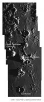
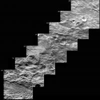
Senior Member Group: Members Posts: 2492 Joined: 15-January 05 From: center Italy Member No.: 150 |
Damn, Bob, you're right!
 They say: "From these distances, a series of images could be obtained with some overlap between them, that allowed to build a mosaic during a good part of the orbit". Partial result should be something like this:
These are only 7 frames (I excluded very first ones due to heavy over-exposure); some enlargement was needed on first ones, so spacecraft was in the approaching phase of it's elongated orbit (1000x5000 Km). Any volunteer wants to complete this work for entire orbit?
-------------------- I always think before posting! - Marco -
|
|
|
|
|
|
|
Jul 1 2006, 08:34 AM
Post
#98
|
||
|
Senior Member Group: Members Posts: 2492 Joined: 15-January 05 From: center Italy Member No.: 150 |
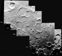
...and this is the final portion, showing north polar region between Carpenter and Goja craters:
Attached thumbnail(s)
-------------------- I always think before posting! - Marco -
|
|
|
|
|
|
|
Jul 1 2006, 01:49 PM
Post
#99
|
|
|
Senior Member Group: Members Posts: 2488 Joined: 17-April 05 From: Glasgow, Scotland, UK Member No.: 239 |
QUOTE (dilo @ Jul 1 2006, 09:34 AM) ...and this is the final portion, showing north polar region between Carpenter and Goja craters: Marco: Good stuff! It's sad that we're reduced to silly things like frame-grabbing, but at least there's something there for us to play with at last. Bob Shaw -------------------- Remember: Time Flies like the wind - but Fruit Flies like bananas!
|
|
|
|
|
Aug 10 2006, 05:05 AM
Post
#100
|
||
|
Senior Member Group: Members Posts: 2492 Joined: 15-January 05 From: center Italy Member No.: 150 |
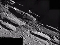
An oblique look on the north lunar far west:
http://www.esa.int/SPECIALS/SMART-1/SEM787BUQPE_1.html Here below an enhanced version (note the strange solarization effect on bright features around the low/left missec box)
Attached thumbnail(s)
-------------------- I always think before posting! - Marco -
|
|
|
|
|
|
|

|
Lo-Fi Version | Time is now: 13th May 2024 - 02:52 PM |
|
RULES AND GUIDELINES Please read the Forum Rules and Guidelines before posting. IMAGE COPYRIGHT |
OPINIONS AND MODERATION Opinions expressed on UnmannedSpaceflight.com are those of the individual posters and do not necessarily reflect the opinions of UnmannedSpaceflight.com or The Planetary Society. The all-volunteer UnmannedSpaceflight.com moderation team is wholly independent of The Planetary Society. The Planetary Society has no influence over decisions made by the UnmannedSpaceflight.com moderators. |
SUPPORT THE FORUM Unmannedspaceflight.com is funded by the Planetary Society. Please consider supporting our work and many other projects by donating to the Society or becoming a member. |
|