Lunar Spacecraft Images, A place for moon panoramas, mosaics etc. |

  |
Lunar Spacecraft Images, A place for moon panoramas, mosaics etc. |
 Jun 2 2006, 11:29 AM Jun 2 2006, 11:29 AM
Post
#122
|
|
 Member  Group: Members Posts: 562 Joined: 29-March 05 Member No.: 221 |
40 years ago today is the anniversary of Surveyor 1, the first soft landing on the moon. BBC article
FTFA: The Surveyor 1 craft landed at 0617 GMT in the Ocean of Storms, about 590 miles (950 km) from where Luna 9 came down. |
 |
 
|
|
Jun 2 2006, 12:34 PM
Post
#123
|
|
 Senior Member Group: Members Posts: 2488 Joined: 17-April 05 From: Glasgow, Scotland, UK Member No.: 239 |
On the Honeysuckle Creek web page are to be found some terrific MP3s of off-air recordings of the landing and the first images, Jack King doing his stuff. The BBC fired up in the middle of the night (an unknown thing in the 1960s) and I saw the first images 'Live from the Moon' as the caption read.
Happy days: http://honeysucklecreek.net/msfn_missions/...pollo/Surveyor/ Bob Shaw -------------------- Remember: Time Flies like the wind - but Fruit Flies like bananas!
|
|
|
|
| Guest_BruceMoomaw_* |
Jun 3 2006, 02:17 AM
Post
#124
|
|
Guests |
Yep. I stayed up all night for it myself (in Missouri). I rmember how delighted everyone was -- after the travails with Ranger -- that this time they'd succeeded on the first try and the Lunar Curse was apparently really broken. I also remember how lousy that first 200-line photo of the footpad was -- although the shower of horizon views that came in a little while later was much better.
I also stayed up all night to get TV coverage of the Viking 1 landing -- but, incredibly, the TV networks didn't bother to cover it live on the West Coast! I was only able to get live coverage of the landing from one 30-second announcement on the radio, and I had to wait about 2 hours for "The Today Show" to show the first photos from the surface. I have no idea why the networks thought no one would be interested in that -- whereas 21 years later they drowned us in Pathfinder coverage. |
|
|
|
|
Jun 3 2006, 01:59 PM
Post
#125
|
|
|
Senior Member Group: Members Posts: 2488 Joined: 17-April 05 From: Glasgow, Scotland, UK Member No.: 239 |
Bruce:
Viking 1 landed in mid-afternoon in the UK, and the BBC covered it as well as they could - I can still remember seeing that first 'letterbox' image of the footpad. They apologised for the picture being in B&W, but that made no odds so far as I was concerned, as I only had a B&W TV!. The papers here gave it good coverage, too - right down to a spoof advert from Cadburys (the food company), announcing that proof of intelligent life on Mars had been found (a faked-up image of a packet of Smash instant mashed potato, as promoted by the Smash Martians in TV ads!). Bob Shaw -------------------- Remember: Time Flies like the wind - but Fruit Flies like bananas!
|
|
|
|
|
Jun 3 2006, 02:18 PM
Post
#126
|
|
|
Solar System Cartographer Group: Members Posts: 10152 Joined: 5-April 05 From: Canada Member No.: 227 |
I detect another case of Topic Drift!
I too recall Viking 1. I was living at the last place on the road on northern Vancouver Island, Winter Harbour. This was back in my bush hippie days, you understand. Now I'm an urban hippie. We lived in a wood house without a TV, but there was one just up the hill in the local one room school. Luckily my wife was the teacher so I had access to it. I snuck up there to watch the TV news and got to see the first image release. I was still there when the first Voyager images of the Galilean satellites were released, but by then we had a TV with the world's crummiest reception at home. Phil -------------------- ... because the Solar System ain't gonna map itself.
Also to be found posting similar content on https://mastodon.social/@PhilStooke Maps for download (free PD: https://upload.wikimedia.org/wikipedia/comm...Cartography.pdf NOTE: everything created by me which I post on UMSF is considered to be in the public domain (NOT CC, public domain) |
|
|
|
|
May 25 2007, 07:56 PM
Post
#127
|
|
|
Member Group: Members Posts: 169 Joined: 17-March 06 Member No.: 709 |
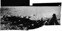
I noticed a sequence of photos from the Apollo 12 mission that might make an
interesting mosaic. These appear to be part of a pan taken by the astronauts near a small crater (named Block) that is inside the Surveyor crater. These photos are from the Apolo Image Gallery, which is part of the Apollo Archive. Go to this link - http://www.apolloarchive.com/apollo_gallery.html Go to the Apollo 12 collection and scroll down to EVA 2, and specifically, to image AS12-48-7145, which shows Surveyor 3, even though the caption does not mention that. It appears that the pan starts at AS12-48-7140 and continues through to -7147. I am not proficient enough to stitch these together, but I believe that someone in the UMSF community could perform such magic. Another Phil |
|
|
|
|
May 25 2007, 10:14 PM
Post
#128
|
|||
|
Solar System Cartographer Group: Members Posts: 10152 Joined: 5-April 05 From: Canada Member No.: 227 |
You mean like this?
Phil
-------------------- ... because the Solar System ain't gonna map itself.
Also to be found posting similar content on https://mastodon.social/@PhilStooke Maps for download (free PD: https://upload.wikimedia.org/wikipedia/comm...Cartography.pdf NOTE: everything created by me which I post on UMSF is considered to be in the public domain (NOT CC, public domain) |
||
|
|
|
||
|
May 28 2007, 03:41 PM
Post
#129
|
|
|
Member Group: Members Posts: 169 Joined: 17-March 06 Member No.: 709 |
Phil S. - That is exactly what I mean! Thanks.
A few thoughts about those mosaics. First, they give one a better "feel" for how close the Apollo 12 LM landed to Surveyor 3. Second, they give a good benchmark to compare to Surveyor 3's own mosaics of the interior of Surveyor Crater produced in 1967. Third, they show just how steep was the landing spot of the Apollo 12 LM. It seems to sitting right on the rim of Surveyor Crater, tipping a bit more than other photos indicate. Another Phil |
|
|
|
|
May 28 2007, 05:44 PM
Post
#130
|
|
 Senior Member Group: Members Posts: 3419 Joined: 9-February 04 From: Minneapolis, MN, USA Member No.: 15 |
Actually, the apparent tilt of Intrepid is an illusion because of its proximity to the edge of the scene. Even the best lenses can introduce distortions near the edge of the scene.
According to every other source (including the LM's guidance system), Intrepid landed almost completely flat, almost no pitch and roll excursions. The landing point was indeed only about 5 meters beyond the lip of the Surveyor crater, and had Pete landed her just a little bit shorter than he did, she would have ended up on a significant slope. As it was, there was barely room for unloading the ALSEP. But yes, these pans do give a very good comparison to the Surveyor pans. Especially nice is the detail it shows in Block Crater... very nice. Thanks for finding these, Phil! -the other Doug -------------------- The trouble ain't that there is too many fools, but that the lightning ain't distributed right. -Mark Twain
|
|
|
|
|
May 28 2007, 06:25 PM
Post
#131
|
|
|
Solar System Cartographer Group: Members Posts: 10152 Joined: 5-April 05 From: Canada Member No.: 227 |
Actually, I didn't find them, I made them. I have assembled every pan from Apollos 11, 12 and 14, and a selection from the three remaining missions. One day I might get them up on my website. Some of my pans look a bit distorted because I have made exact fits at each seam instead of doing what many people have done in the past (just feathered the boundaries). I will post some here.
Phil -------------------- ... because the Solar System ain't gonna map itself.
Also to be found posting similar content on https://mastodon.social/@PhilStooke Maps for download (free PD: https://upload.wikimedia.org/wikipedia/comm...Cartography.pdf NOTE: everything created by me which I post on UMSF is considered to be in the public domain (NOT CC, public domain) |
|
|
|
|
May 28 2007, 07:42 PM
Post
#132
|
|
|
Member Group: Members Posts: 129 Joined: 25-March 05 Member No.: 218 |
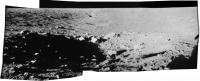
On Apollo 12 there are those well know images taken from Surveyor looking back up the slope to the LM. But I've never seen any from the LM area into the crater showing Surveyor. The closest I've been able to find is possibly this panorama... where just poking up from the shadowed interior, just above the near side sunlit lip of the crater is something that looks like the solar panel (on top of the mast... which is below the lip). Don't know if that's it, but it looks like a hard edges of the right shape.
http://moonpans.com/vr/apollo12_lm.htm (You need quicktime to view the 360 pan) |
|
|
|
|
May 28 2007, 08:33 PM
Post
#133
|
|
 Interplanetary Dumpster Diver Group: Admin Posts: 4404 Joined: 17-February 04 From: Powell, TN Member No.: 33 |
I thought Phil found them in an ally under the red sky.... (if there are are any other Dylan fans, you might figure out what I am quoting).
-------------------- |
|
|
|
|
May 28 2007, 09:23 PM
Post
#134
|
||
|
Solar System Cartographer Group: Members Posts: 10152 Joined: 5-April 05 From: Canada Member No.: 227 |
Hmm... am I the little boy or the old man?
Anyway, here's one such pan from EVA 1, Station 2 on Apollo 15. Compare it with the version on the Apollo Lunar Surface Journal, and you will see the interruption in the middle (caused by the astronaut stumbling on the steep slope) is wrongly represented on ALSJ. The tracks don't connect properly. Phil
-------------------- ... because the Solar System ain't gonna map itself.
Also to be found posting similar content on https://mastodon.social/@PhilStooke Maps for download (free PD: https://upload.wikimedia.org/wikipedia/comm...Cartography.pdf NOTE: everything created by me which I post on UMSF is considered to be in the public domain (NOT CC, public domain) |
|
|
|
|
|
|
May 29 2007, 06:52 AM
Post
#135
|
|
|
Senior Member Group: Members Posts: 3419 Joined: 9-February 04 From: Minneapolis, MN, USA Member No.: 15 |
QUOTE (RedSky @ May 28 2007, 02:42 PM)  On Apollo 12 there are those well know images taken from Surveyor looking back up the slope to the LM. But I've never seen any from the LM area into the crater showing Surveyor. The closest I've been able to find is possibly this panorama... where just poking up from the shadowed interior, just above the near side sunlit lip of the crater is something that looks like the solar panel (on top of the mast... which is below the lip). Don't know if that's it, but it looks like a hard edges of the right shape. Yes, that's the Surveyor in that pan. I've only seen two images of the Surveyor Crater, which include the Surveyor, taken from the LM landing site, both taken during EVA-1 pans. The one you linked is the better of the two, you can actually make out not only the solar panel and antenna (which were in sunlight), but also the triangular shape of the landing gear structure. The Sun was only about 5 or 6 degrees above the horizon during Apollo 12's first EVA, so the shadow of the crater rim fell about one-third of the way down Surveyor's antenna/solar panel mast. The other image, from approximately the same perspective, was taken with a higher F-stop and the shadowed portion of the crater shows much less detail. In that picture, only the solar panel and antenna are visible, you can't see anything of the landing gear structure. Of course, the human eye has a much greater dynamic range than the film stock used during Apollo (or any film stock, for that matter). When Pete Conrad took three steps to clear the LM and look back into the Surveyor Crater, just after he stepped onto the surface, he could clearly see the entire probe, even though most of it was in shadow. (It was illuminated by light backscattered from the opposite, sunlit crater wall.) That's why he cackled, almost immediately after setting foot on the surface, "Guess what I see sitting on the side of that crater?" -the other Doug -------------------- The trouble ain't that there is too many fools, but that the lightning ain't distributed right. -Mark Twain
|
|
|
|
|
May 31 2007, 02:14 PM
Post
#136
|
|
|
Interplanetary Dumpster Diver Group: Admin Posts: 4404 Joined: 17-February 04 From: Powell, TN Member No.: 33 |
Definitely the old man...I'm not saying you're old, but he lived in the moon, so that would explain your "reprocessed" lunar images.
-------------------- |
|
|
|
|

|
Lo-Fi Version | Time is now: 26th April 2024 - 08:20 PM |
|
RULES AND GUIDELINES Please read the Forum Rules and Guidelines before posting. IMAGE COPYRIGHT |
OPINIONS AND MODERATION Opinions expressed on UnmannedSpaceflight.com are those of the individual posters and do not necessarily reflect the opinions of UnmannedSpaceflight.com or The Planetary Society. The all-volunteer UnmannedSpaceflight.com moderation team is wholly independent of The Planetary Society. The Planetary Society has no influence over decisions made by the UnmannedSpaceflight.com moderators. |
SUPPORT THE FORUM Unmannedspaceflight.com is funded by the Planetary Society. Please consider supporting our work and many other projects by donating to the Society or becoming a member. |
|