Printable Version of Topic
Click here to view this topic in its original format
Unmanned Spaceflight.com _ Spirit _ McCool Hill
Posted by: jvandriel Mar 12 2006, 09:24 PM
It is time for a new thread now Spirit is on it's way to McCool Hill to survive the Marsian winter.
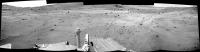
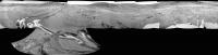
Here is a panorama from McCool Hill taken on Sol 777 with the R2 pancam.
Almost from the same place as the panorama taken on Sol 776.
jvandriel
|
|
Posted by: Phillip Mar 12 2006, 11:17 PM
Anyone want to hazard a guess as to her path up McCool Hill?
Phillip
Posted by: Bill Harris Mar 13 2006, 03:05 AM
The route is under discussion at :
http://www.unmannedspaceflight.com/index.php?showtopic=2326
My speculation is at:
http://www.unmannedspaceflight.com/index.php?s=&showtopic=2326&view=findpost&p=44205
--Bill
Posted by: abalone Mar 13 2006, 12:29 PM

Phillip
I think the boundary of the lighter colored deposits on the hill will feature prominently in the path chosen
Posted by: Shaka Mar 13 2006, 07:02 PM
If you're talking about the broad swath on the upper right hillside, I doubt we can go there till spring. It faces more west than north. I don't expect we will continue moving toward Oberth for the same reason. Once we cross the valley, we need to head toward Korolev. Actually, I think we need to approach Korolev on the flat, and only start to ascend when we get close. Tilting the solar panels westward will not help us.
Posted by: deglr6328 Mar 14 2006, 09:11 AM
do we know the elevation of this hill?
Posted by: Ant103 Mar 14 2006, 09:25 AM
This hill is higher than Husband Hill, who is at 90~100 m. So, this hill may be 120 - 130 m high, I think...
Posted by: paxdan Mar 14 2006, 11:39 AM
http://marsrovers.jpl.nasa.gov/spotlight/20060302.html Li's team estimates McCool Hill to be 436 feet, 133 m above Spirit's landing site (compared with Husband Hill's 351 feet, 107 m elevation above the landing site). That is to say that McCool is 85 feet or 26 m higer than Husband Hill.
Note the above values are elevation above the landing site, not the elevation of the hills from their base on the plains.
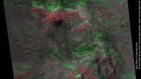
Posted by: djellison Mar 15 2006, 10:43 PM
Green slope good, red slope bad - very rough and ready, but it gives some sort of idea 
Doug
|
Posted by: helvick Mar 15 2006, 11:03 PM
Do you have that DEM?
Posted by: Shaka Mar 15 2006, 11:24 PM
Doug
Amazing. How was this produced? But it makes it look like we should be running southeast from HP, not northeast. Why am I confused?
 Is the dark green to the SE way up near the summit?
Posted by: djellison Mar 16 2006, 09:43 AM
We are going SE generally. Any one day's drive may not be in the exact direction of the over all goal - but it may be the best route that offers progress in the route required.
That was made using an elevation map derived from a DEM (which Helvick should have shortly ) and then in a 3D animation package - I simply put a green light source to the north, and a red one to the south - so the related slopes were illuminated appropriately.
Doug
Posted by: Steve Mar 16 2006, 01:50 PM
Doug
My only concern is that it might miss some of the forenoon and afternoon illumination. Could you consider another try adding other greenish lights at northeast and southeast; perhaps blue-green at one corner and yellowish green at the other.
If you need precision, and your spherical astronomy is fresher than mine
 , you could compute the illuminaton angles for winter solstice around 0900 and 1500 Local Apparent Time.
OOPS -- I meant northeast and northwest
Posted by: helvick Mar 16 2006, 07:56 PM
, you could compute the illuminaton angles for winter solstice around 0900 and 1500 Local Apparent Time.I intend to do something like that but it's going to be later in the weekend - real life work has cought up with me big time and I have some deadlines to meet.
My plan is to integrate the daily insolation in hourly slices. The current model that I have takes about 100 seconds to do a full martian year on a Sol by sol basis _for_ a single position using a 20 minute time slice so I should be able to generate a 1024x1024 grid in about 30 minutes for a single sol. I think. I can cache a bunch of intermediate calculations for this though so I might be able to get an order of magnitude maybe even 2 of a speed boost once I look at it properly.
Posted by: jvandriel Mar 16 2006, 08:41 PM
A panoramic view on Sol 781.
Taken with the L0 navcam.
jvandriel
|
|
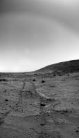
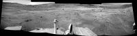
Posted by: jvandriel Mar 17 2006, 08:22 AM
Spirit looking back at the wheeltracks and Husband Hill on Sol 780.
Taken with the L0 navcam.
jvandriel
|
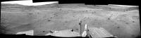
Posted by: jvandriel Mar 17 2006, 08:46 AM
A view into the drive direction on Sol 781.
Taken with the L0 navcam.
jvandriel
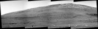
McCool Hill.
A panoramic view on Sol 781.
Taken with the L7 pancam.
jvandriel
|
|
|
Posted by: jvandriel Mar 20 2006, 11:23 AM
The view looking forward on Sol 782.
Taken with the L0 navcam.
jvandriel
and almost the same view on Sol 784.
Taken with the L0 navcam.
jvandriel
|
|
Posted by: jvandriel Mar 20 2006, 02:31 PM
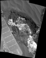
A panoramic view of McCool Hill and part of the foreground.
Taken on Sol 777 and Sol 778 with the L2 pancam.
jvandriel
Here is the complete view of McCool Hill from Sol 781.
Taken with the L7 pancam.
jvandriel
|
|
|
|
Posted by: jvandriel Mar 20 2006, 03:10 PM
A view into the drive direction on Sol 783.
Taken with the L7 pancam.
jvandriel
|
|
Posted by: jvandriel Mar 23 2006, 10:23 AM
The view into the new drive direction after the turn.
Taken with the L7 pancam on Sol 787.
jvandriel
|
|
Posted by: jvandriel Mar 26 2006, 11:33 AM
The drive direction on Sol 788.
Taken with the L7 pancam.
jvandriel
|
|
Posted by: Oersted Mar 26 2006, 03:08 PM
thx a lot for the views, much appreciated.
Posted by: jvandriel Mar 27 2006, 09:55 AM
A view looking back at Husband Hill and West Spur.
Taken on Sol 788 with the L0 navcam.
jvandriel
|
Posted by: centsworth_II Mar 27 2006, 05:27 PM
Can West Spur be seen fron the Inner Basin? Maybe that's the "lookout point" that Spirit was originally supposed to head for after arrival at West Spur. Before the arrival of winter required sticking to the north side of Husband Hill.
Posted by: Phil Stooke Mar 27 2006, 05:59 PM
centsworth_II is correct. This is Lookout Point.
Phil
Posted by: centsworth_II Mar 27 2006, 06:17 PM
Here is a link with a good view of the relationship of Inner Basin, Lookout Point and West Spur. Remember when Lookout Point was the planned destination after West Spur? I think the "detour" to the top of Husband Hill was a much more interesting trip.
http://www.marstoday.com/viewsr.html?pid=12928
Posted by: jvandriel Mar 27 2006, 07:10 PM
centsworth II
You are correct. It is Lookout Point.
My mistake. Sorry.
jvandriel
Posted by: CosmicRocker Mar 28 2006, 06:16 AM
Good catch. I have been looking back for a glimpse of Lookout Point for a while. Now I find myself sleeping at the critical moment. I was kind of hoping for a closer view, though.
Posted by: centsworth_II Mar 28 2006, 07:14 AM
I'm glad you posted that image, jvandriel. Looking back at Lookout Point made me very nostalgic. Spirit never visited that spot, but it figured very prominently in the planning as the rover approached the Columbia Hills. It makes me think of Spirit's saga, the paths taken and those not. Lookout point turned out to be one of the paths not taken, but Spirit did reach Homeplate which was as far as anyone ever dreamed she could get. She's old and hobbled now, but what a life she has lived.
As I said, I'm feeling nostalgic, but I don't mean for this to sound like a eulogy. Spirit has plenty of life left and more discoveries to make.
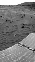
Posted by: jvandriel Mar 28 2006, 01:28 PM
A view of the wheeltracks before and after the left turn.
Taken on Sol 792 with the R0 navcam.
jvandriel
|
Posted by: MaxSt Mar 28 2006, 04:09 PM
http://marsrovers.jpl.nasa.gov/gallery/all/2/n/756/2N193476275EFFAOC6P0605R0M1.JPG
Posted by: jvandriel Mar 28 2006, 06:03 PM
A view into the drive direction.
Taken on Sol 792 with the L0 navcam.
jvandriel
|
Posted by: CosmicRocker Mar 29 2006, 06:33 AM
That's not quite the closer view I had in mind. I was kind of thinking along the lines of centsworth_II's nostalgic comment regarding the alternate paths that might have been taken. Where would we be if Spirit had taken the less arduous path around the hill to find the buried treasure. There is not a lot of value to be had from second guessing such decisions when exploring an alien world. We need to see what is around the next corner, if we can make it there.
Posted by: Vladimorka Mar 29 2006, 08:52 AM
Taken on Sol 792 with the L0 navcam.
jvandriel
Is http://marsrovers.jpl.nasa.gov/gallery/all/2/n/792/2N196679971EFFAQCYP1908R0M1.HTML frost? If it is, can it do some dust cleaning? When the frost sublimates from the solar panel may be it can carry some dust particles with it?
Posted by: djellison Mar 29 2006, 11:17 AM
At 13:45:38 Mars local solar ? Not a chance. Remember the frost that Opportunity had - it vanished within hours of sunrise. It's a bad image stretch - that's just dust that's being bright.
Doug
Posted by: AndyG Mar 29 2006, 11:56 AM
I'd be surprised, quite frankly. As the ice turns directly to water vapour I can't see it affecting the dust at all. These rovers need honest-to-goodness dreich Scottish weather. ;-)
Andy G
Posted by: edstrick Mar 29 2006, 01:21 PM
Jvandriel: ..."A view of the wheeltracks before and after the left turn"...
I'm afraid Spirit's been drinking again... and at such a tender age!
Posted by: Bob Shaw Mar 29 2006, 02:24 PM
Andy G
Andy:
Nobody *needs* dreich Scottish weather.
Now kindly explain the use of the 'd' word to the colonials!
Bob Shaw
Posted by: Bill Harris Mar 29 2006, 04:54 PM
OMG, google "dreich" and you come up with a whole new dialect of english. Too bad that the Brits and Welsh murdered it, but the Scots seem to have gotten creative, too.
http://www.rampantscotland.com/parliamo/blparliamo_weather.htm
--Bill
Posted by: sattrackpro Mar 30 2006, 03:33 AM
Doug
My take as well, Doug. Dust! It's more likely that the 'frost' we saw before was composed of pure carbon dioxide - dry ice... with zero H2O involvement no matter how much one might wish it were otherwise.
With the low gravity of Mars, the atmosphere is decreasing at a high rate - increased geometrically by solar bombardment, which further accelerates the break up of heavier atmospheric molecules and resultant lighter-ion planetary escape - water vapor being the most vulnerable to such radiation break up.
An aside, the idea that pools of surface water will be found on Mars is laughable. Liquid water cannot exist on Mars due to the fact that the atmospheric pressure (over ten times lower than that of earth and getting lower) simply precludes the possibility.
Posted by: paulanderson Mar 30 2006, 06:57 AM
With the low gravity of Mars, the atmosphere is decreasing at a high rate - increased geometrically by solar bombardment, which further accelerates the break up of heavier atmospheric molecules and resultant lighter-ion planetary escape - water vapor being the most vulnerable to such radiation break up.
An aside, the idea that pools of surface water will be found on Mars is laughable. Liquid water cannot exist on Mars due to the fact that the atmospheric pressure (over ten times lower than that of earth and getting lower) simply precludes the possibility.
The MER team had already indicated, back in 2004, that the frost seen on Opportunity was ordinary water frost. Re Vladimorka's and AndyG's posts, they also indicated that the frost could perhaps affect the dust on the solar panels; both topics mentioned here:
http://marsrovers.jpl.nasa.gov/newsroom/pressreleases/20041213a.html
"A portion of Mars' water vapor is moving from the north pole toward the south pole during the current northern-summer and southern-winter period. The transient increase in atmospheric water at Meridiani, just south of the equator, plus low temperatures near the surface, contribute to appearance of the clouds and frost, Wolff said. Frost shows up some mornings on the rover itself. The possibility that it has a clumping effect on the accumulated dust on solar panels is under consideration as a factor in unexpected boosts of electric output from the panels."
While open pools of water might be much more unlikely, I agree, there is still a good chance of minute quantities of liquid water within the soil itself. What about the lab studies showing this as possible, notably briny water that could persist longer than originally believed, which were extensively discussed not long ago? Have we already forgotten about that?
Posted by: jvandriel Mar 30 2006, 09:59 AM
The panoramic view on Sol 794.
Spirit is backing of to find another path to McCool Hill.
Taken with the L0 navcam.
jvandriel
|
|
Posted by: jvandriel Mar 31 2006, 10:44 AM
Here is the almost complete 360 degree panoramic view from Sol 794 and Sol 795.
Taken with the L0 navcam.
jvandriel
|
|
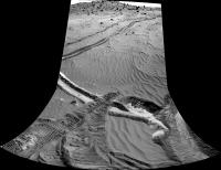
Posted by: jvandriel Mar 31 2006, 12:04 PM
Here is the complete 360 degree panoramic view from Sol 792 Sol 794 and Sol 795.
To put the wheeltracks in their context.
3 Sols and 2 different locations stitched by Autostitch. ( Almost perfect )
Images taken by the L0 navcam.
jvandriel
|
Posted by: jvandriel Apr 1 2006, 01:51 PM
Spirit looking back with the L7 pancam on Sol 796.
jvandriel
|
|
Posted by: jvandriel Apr 3 2006, 09:14 AM
Looking down.
Another view of the wheel and the wheeltracks.
Mosaic taken with the R1 pancam on Sol 799.
jvandriel
|
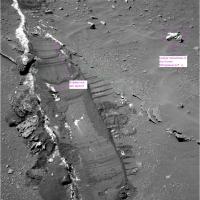
Posted by: Marz Apr 11 2006, 07:51 PM
Well, I guess we're gonna get very familar with Spirit's current locale.
Let's start off by trying to decide if it's an extension of Homeplate:
http://qt.exploratorium.edu/mars/spirit/pancam/2006-04-11/2P198005146EFFAR00P2406R1M1.JPG
Looks like the wheel scuffed over two layered rock segments, and when the wheel scuffed the edge, it looked like sulfates.
So are these layered rocks near Low Ridge Haven related to Homeplate? (which is now thought to be an ash deposit?) Can Spirit essentially study the Homeplate formation from her winter hideaway?
Here's the same image above with lines to show the rock layers I'm referring to:
(Doug can delete it if it breaks a rule for lame photo-editing) 
|
Powered by Invision Power Board (http://www.invisionboard.com)
© Invision Power Services (http://www.invisionpower.com)