Printable Version of Topic
Click here to view this topic in its original format
Unmanned Spaceflight.com _ New Horizons _ New Horizons: Near Encounter Phase
Posted by: elakdawalla Mar 11 2015, 01:49 AM
The plans for the Near Encounter Phase of the New Horizons mission have been set in stone since 2009. http://pluto.jhuapl.edu/Mission/The-Path-to-Pluto/NH_Obs_Playbook_LORRI-MVIC.pdf -- not only the timing and geometry, but also when it is going to be played back. http://www.planetary.org/blogs/emily-lakdawalla/2015/03101637-pluto-image-expectations.html. Some of the things I learned while writing that article that are of interest to this forum:
- Not a lot of data is being returned right away (in fact, only 1% gets returned within a week of the flyby).
- After July 20, there will be a long dry spell of no images being returned until the browse data set starts coming down on September 16.
- There will not be much scope for image processing on the data that is being returned near the flyby. There are one or two pairs of images that you can use to make stereo; there are two mosaics; there is one MVIC image for which there is LORRI data returned near enough in time to do colorization.
So it's going to be awesome, but we're also going to have to be patient!
Here is my simulation, using Voyager data, of the LORRI data set that we can expect to have on the ground as of July 20.
http://www.planetary.org/multimedia/space-images/charts/simulation-of-nh-lorri-data-set.html
Posted by: Mercure Mar 19 2015, 12:03 AM
Thanks so much for this very informative chart. Is the entire New-Horizons-facing Pluto hemisphere expected to be documented at 0.4km/pix resolution?
Posted by: elakdawalla Mar 19 2015, 02:54 PM
Not all of it; there is a 15-footprint mosaic that covers maybe 30% of the visible disk. It's on page 20 of the Playbook I linked to in my post.
Posted by: Mercure Mar 20 2015, 08:28 PM
Thank you! - Your chart is an excellent overview of the visuals to expect. The playbook has all the info, but your graphic is more digestible for those of us with limited time due to real life constraits (i.e. job and toddlers :-)
Posted by: Jaro_in_Montreal Mar 21 2015, 08:32 AM
That's interesting.....
So, what happens between the time of the 15 highest-rez photos from 77,298km range (p.20) and the time when lower-rez photos are taken before (254,072km range, p.17) and after (359,895km range, p.22) ?
I realize it's all done on July 14, but just how long does it take to get each of the 15 hi-rez photos? ....one might be tempted to think that a more complete hemispheric coverage could be had. Why not ? (Thnx)

|
Posted by: nprev Mar 21 2015, 08:45 AM
Primarily because NH's downlink bit-rate at that distance will be around 1kb/sec. Also, imagery obviously won't be the only data coming down and the DSN is a finite resource set that can't be dedicated to NH alone.
Excellent (as always) relevant blog article by Emily http://www.planetary.org/blogs/emily-lakdawalla/2015/01300800-talking-to-pluto-is-hard.html.
Posted by: jgoldader Mar 21 2015, 11:11 AM

So, what happens between the time of the 15 highest-rez photos from 77,298km range (p.20) and the time when lower-rez photos are taken before (254,072km range, p.17) and after (359,895km range, p.22) ?
I realize it's all done on July 14, but just how long does it take to get each of the 15 hi-rez photos? ....one might be tempted to think that a more complete hemispheric coverage could be had. Why not ? (Thnx)
A couple of possibilities come to mind, but they all lead back to a mix of too little time and finite storage capacity, and lots of choices on how to spend them.
If you look at the last panel in the figure you attached, you can see that it would take about 3x as many images to cover the expected error ellipse to be sure of getting the whole planet, so 3x as much time and 3x as much data.
This flyby isn't just about imaging, and there are tradeoffs, and I bet the meeting where the 15 images were settled upon was "interesting." Spectroscopy and occultations are also on the list, and those are going to take time and data as well. Since NH has to turn the whole spacecraft to point the instruments, it's not possible to get useful data from all the instruments at the same time. And don't forget the satellites, we want data on those as well.
But my gut tells me it's probably the amount of storage available on the spacecraft that limits the number of images, in the end. Maybe John will chime in to give the real answer.
Jeff
Posted by: john_s Mar 21 2015, 02:45 PM
The scarcest resource during the close approach period is time rather than data volume. The spacecraft is designed to do fast turns (up to 1.25 degree/sec) to observe as many targets as possible during the close approach period, but still, each mosaic repointing takes time to settle before we can be sure of a sharp image, time is needed to allocate the memory for recording each set of data, and so on. To answer the specific question, that 15-image Pluto mosaic takes about 20 minutes, and is preceded by Nix observations (hi-res imaging and our best infrared compositional map), and followed by our best infrared compositional map of Charon.
We do get most of the visible disk of Pluto at 0.3 km/pixel with our wide-angle camera MVIC near closest approach, and the whole disk at 0.46 km/pixel with MVIC ten minutes earlier- part of the purpose of that 15-image LORRI mosaic is to provide stereo coverage with the closer MVIC scans.
There were indeed many lively meetings to figure all this out, but they were almost never acrimonious- the entire science team understands the importance of the holistic view of the system that will be provided by all these wonderful overlapping data sets.
John
Posted by: Alan Stern Mar 21 2015, 03:54 PM
We do get most of the visible disk of Pluto at 0.3 km/pixel with our wide-angle camera MVIC near closest approach, and the whole disk at 0.46 km/pixel with MVIC ten minutes earlier- part of the purpose of that 15-image LORRI mosaic is to provide stereo coverage with the closer MVIC scans.
There were indeed many lively meetings to figure all this out, but they were almost never acrimonious- the entire science team understands the importance of the holistic view of the system that will be provided by all these wonderful overlapping data sets.
John
John is right, the NH sequence planning team for Pluto encounter was exceptionally collegial. The mapping he describes beats the NASA spec requirement for hemispheric mapping of 1 km by a healthy margin, and adds the high-res mosaic. We beat NASA spec for Pluto color mapping and composition mapping by healthy margins too. Amazing data sets are in store!
Posted by: jgoldader Mar 21 2015, 05:54 PM
Shows what I know!

Thanks John and Alan!
Posted by: Decepticon Mar 21 2015, 06:35 PM
Jaro where did you get that image from?
Posted by: Gerald Mar 21 2015, 06:40 PM
Page 20 of the http://pluto.jhuapl.edu/Mission/The-Path-to-Pluto/NH_Obs_Playbook_LORRI-MVIC.pdf.
Posted by: Alan Stern Mar 21 2015, 07:10 PM
One note, this is only one of several Observation Playbooks. Others will be posted later on approach, covering other instruments and disciplines beyond just surface mapping by LORRI and MVIC. Stay tuned...
Posted by: hendric Mar 21 2015, 10:52 PM
Thanks Alan for letting us "in the conference room!"
Posted by: Ian R Mar 22 2015, 04:45 AM
Seconded!
Posted by: Eric H. Mar 22 2015, 05:33 AM
Thirded! I haven't been this excited since Voyager 2 encountered Neptune back in 1989!
Posted by: TheAnt Mar 22 2015, 07:57 PM
Thank you for letting us get an insight via your "Observation Playbook".
I can only echo what already been said, that this will indeed be one interesting encounter.
Now I hope you give NH another good workout so she wont sprain a muscle during that intense cosmic ballet performance. =)
Posted by: tedstryk Mar 23 2015, 02:05 AM
I will chime in and say that a major part in New Horizons success thus far has been its team dynamic. I have been amazed, given the competing priorities, at the cooperative spirit with which things are dealt with.
Posted by: nprev Jul 13 2015, 01:53 PM
Good morning from Los Angeles! Today marks the beginning of the near encounter phase. http://www.nasa.gov/press-release/nasa-pluto-new-horizons-july-13-media-briefing-time-change-media-center-open will air the pre-flyby briefing at 1430 GMT today (13 Jul). Note that all times are subject to change as events unfold.
Please utilize this thread for all New Horizons commentary for the next several days. Here we go!!! 
Posted by: Nafnlaus Jul 13 2015, 02:09 PM
One thing that was being discussed in the last thread, about all of the features that look like "rivers" or "lakes" and the criticism that Pluto's pressure is too low for, say, liquid nitrogen to flow:
Given a triple point pressure of around 12kPa and a solid density of 1027 kg/m^3, 3,2kPa surface pressure, and 0,655m/s^2 pluto surface gravity, Pluto's triple point could be hit underneath as little as 13 meters of nitrogen ice (a bit more, as it would have to have at least a tiny bit of "fluff" to it to float, but that's to be expected). Other ices floating on it such as methane ice could have the same effect. And note that this ice wouldn't be heavily packed due to Pluto's weak gravity, it's the equivalent of less than one meter of nitrogen ice under Earth's gravity. Picture how much a meter of water snow (roughly the same density) packs down on Earth; I'd expect something roughly in the same ballpark - perhaps a situation like arctic sea ice.
Basically, even if there's not liquids flowing on the surface (eutectics or whatnot), there could still be liquids at a shallow depth with a weak ice pack on top of them. And iced-over rivers still flow and move things around.
Posted by: Webscientist Jul 13 2015, 02:14 PM
Thanks for the analysis and the calculations Nafnlaus. That's the relevant problem. I was intersted in peforming that kind of simulations. No need to dig deep for the future lander if you're right. 
Posted by: Nafnlaus Jul 13 2015, 02:20 PM
An interesting thing is that there's a lot of potential liquids and mixtures of liquids / slushes / etc at different (shallow) depths that could be involved here, going through a wide range of dynamic changes as Pluto moves through its seasons. There could be some very complex processes involved in shaping this landscape. I'm sure whatever data comes back, it's going to lead to some very interesting papers down the road
Posted by: nprev Jul 13 2015, 02:29 PM
Briefing placard now up on NASA TV.
Posted by: Explorer1 Jul 13 2015, 02:31 PM
Starting now....
Posted by: Bjorn Jonsson Jul 13 2015, 02:34 PM
I have been attempting to measure Pluto's radius from the images that have been obtained in the past few days. I have consistently been getting a values of 1190-1195 km in most cases (1194 km for the latest image). This is close to the radius that SPICE uses (1195 km) but I have seen smaller values elsewhere. Wikipedia gives two values, 1184 km and "1161 km (solid)". The PDS Rings Node Pluto Viewer seems to use a value of 1153 km (selectable in "Field of View" but I'm not completely sure this is the value used to render the Pluto diagrams - I suspect that value may be bigger).
I haven't measured Charon as thoroughly and not in the latest images but I have usually gotten values of 590-600 km. This isn't very far from the SPICE value (605 km).
Posted by: nprev Jul 13 2015, 02:36 PM
Pluto's polar cap confirmed as N2 & CH4 ices.
Alan states radius as 1185 km +/- 10.
Posted by: Bjorn Jonsson Jul 13 2015, 02:39 PM
Saw this on NASA TV, nice to see measurements from the NH team only minutes after I posted my (much more crude) measurements here.
Posted by: nprev Jul 13 2015, 02:51 PM
By my count, we now have three different pronunciations of "Charon".
Posted by: Paolo Jul 13 2015, 02:56 PM
given how it's written in Greek, "kharon" is the correct one
Posted by: alk3997 Jul 13 2015, 03:01 PM
However, the discoverer's wife's name is Charlene. Therefore the pronunciation is similar to Sharon (or Charlene). Wives usually win...
Posted by: Phil Stooke Jul 13 2015, 03:18 PM
This is absolutely a case where space nerds win out over linguist nerds. The name is only pretending to be Greek. The moon is actually named after the discoverer's wife and is just modified slightly to look like it's mythological, to pass IAU inspection.
Phil
Posted by: xflare Jul 13 2015, 03:28 PM
excellent and informative briefing so far I must say
Posted by: nprev Jul 13 2015, 03:28 PM
The early, distant detection of ionized nitrogen seems to be the most unexpected thing thus far.
Presser wrapping up.
Posted by: Greg Hullender Jul 13 2015, 03:30 PM
Does anyone have an estimate of how much of Pluto will not be imaged at all? Either because it's in the dark or just due to the geometry of the encounter?
Best would be a contour map showing resolution in different regions, but just a measure of the invisible amount would be interesting. Same for Charon.
Posted by: Paolo Jul 13 2015, 03:30 PM
yep, though I expected to see the few LORRI images from yesterday
Posted by: alk3997 Jul 13 2015, 03:33 PM
If I followed Dr. Stern correctly, molecular nitrogen was found five days out of closest approach. Actually at that distance it was ionized nitrogen and is believed to have come from Pluto. The detection was significantly further out than had been expected which *implies* some type of more energetic release mechanism on Pluto. However, the data resolution is too low to really tell at this point.
Also, the methane signature of Pluto's dark regions is significantly lower than that of the polar region.
We all get to add this new information to our image interpretations...
Andy
Posted by: Bjorn Jonsson Jul 13 2015, 03:38 PM
New version of my Pluto map where I have added the 2015-07-11 22:23 image that was released by the NH team last night if I remember correctly (things are happening fast now!). Longitude 0 is at the left edge of the map.
|
Of course this is probably only hours (or possibly even minutes) from getting completely outdated - and if I want to keep the map up to date I soon need to make a bigger version.
Posted by: OWW Jul 13 2015, 03:42 PM
1 million km.
Posted by: nprev Jul 13 2015, 03:42 PM
Next media event will be tomorrow 14 Jul/1130 GMT for closest approach, followed by a presser/image release.
Posted by: Saturns Moon Titan Jul 13 2015, 03:48 PM
Is the media conference going to be uploaded to youtube? I missed it.
Posted by: Marvin Jul 13 2015, 03:52 PM
Things are happening fast now. As mentioned in a previous briefing, we may not see all the data for awhile. But I'm sure they will put out some images and data this week.
I "accidentally" took a screen grab from a monitor during a live feed from NH Mission Operations today:

|
It sure doesn't look like telemetry data. Although it's too small to be useful, if it is an image of Pluto or Charon, it could be a teaser of the kind of resolution and detail we can soon expect. Personally, I think it could be a close up on Pluto...
Posted by: Habukaz Jul 13 2015, 03:57 PM
Björn's map illustrates how the bright areas to the west in the last image release is probably (at the least) a half-decent preview of the rest of heart feature. The bright stuff here is probably similar to the bright stuff in the rest of it. Judging by lower-resolution maps, there were already solid hints that this part would not be some sort of uniform white, however.
Posted by: Julius Jul 13 2015, 04:01 PM
The fact that our closest approach view will include the brightest region and part of the dark region together with other parts in between albedos ,should give us a good representation of all terrain types visualized so far on pluto.
Posted by: Req Jul 13 2015, 04:02 PM
New briefing is up here:
http://www.space-multimedia.nl.eu.org/index.php?option=com_content&view=article&id=9504:nasa-news-briefing-on-new-horizon-mission-status-and-what-to-expect&catid=1:latest
Posted by: paraisosdelsistemasolar Jul 13 2015, 04:20 PM
Just updated the New Horizons image database: http://nchazarra.duckdns.org/db/
Now you can also download the whole records in .csv.
Posted by: nprev Jul 13 2015, 04:38 PM
Omnibus New Horizons info post now up at the http://www.planetary.org/explore/projects/pluto/exploring-pluto.html
Posted by: MahFL Jul 13 2015, 04:42 PM
I "accidentally" took a screen grab from a monitor during a live feed from NH Mission Operations today:
|
|
It sure doesn't look like telemetry data. Although it's too small to be useful, if it is an image of Pluto or Charon, it could be a teaser of the kind of resolution and detail we can soon expect. Personally, I think it could be a close up on Pluto...
I thought it was the NASA TV feed, they were watching themselves on NASA TV, for a few mins.
Posted by: TheAnt Jul 13 2015, 04:44 PM
Now you can also download the whole records in .csv.
Good work, and thank you for including all that information for the images. I bet it will useful for the image tweakers on this forum. =)
Posted by: JRehling Jul 13 2015, 04:46 PM
I guess the leading candidates for the dark stuff are some combination of:
1) Larger hydrocarbons, tholins, maybe the nitriles, etc. seen on Titan.
2) Varied grain sizes that appear darker for physical rather than chemical reasons.
There could be very interesting chemistry which will be difficult to interpret from a distance. We still don't know what the composition of the bulk of Titan's surface is, and NH will return a minuscule fraction of the observations of Pluto that Cassini-Huygens returned from Titan. The only compensation is that spectroscopy of Pluto's surface should not be impaired too much by the atmosphere.
Posted by: Marvin Jul 13 2015, 04:50 PM
Yes, it was on NASA TV, a live feed of Mission Operations after the presentation.
You could sense their excitement, and I don't blame them.
Edit: I just finished watching the replay Req kindly put up on the previous page. Start watching at around 60:42. One of the other staff comes over to check out the image I posted. Looks interesting! There is actually an earlier image to the one I posted if anyone wants to try to grab it.
Posted by: dotancohen Jul 13 2015, 04:53 PM
Now you can also download the whole records in .csv.
Very nice, thank you! Don't test on the live site, your PHP errors were showing!
Could you put a TARGET field on the index table? NH is now specifying whether the target is PLUTO or CHARON, and presumably the other moons may be targeted as well. It would be nice to see this right on the index table.
If you want to clean up that table, I would say that the compression, exposure, and missionphase fields are not really needed on the index table. It doesn't hurt to have them, but it makes the table too wide. Perhaps putting the Show Detail link on the left, instead of on the right, would help in that regard.
Again, thank you for the terrific index!
Posted by: nogal Jul 13 2015, 04:55 PM
Phil
Learn something new everyday! I had always thought it was named after https://en.wikipedia.org/wiki/Charon_%28mythology%29, which would be appropriate since Hades is the ancient name of the underworld god: https://en.wikipedia.org/wiki/Pluto_%28mythology%29. Well disguised indeed!
Fenando
Posted by: alan Jul 13 2015, 05:01 PM
Alan states radius as 1185 km +/- 10.
Bigger than Eris (1165 +/-6 km)
Posted by: fredk Jul 13 2015, 05:07 PM
It's fun to combine Bjorn's maps into an animation showing how the resolution is increasing, from east to west:
|
Posted by: Phil Stooke Jul 13 2015, 05:15 PM
Jim Christie has a good account of the naming of Charon in this interview:
http://www.astronomy.com/year-of-pluto/2015/06/an-interview-with-jim-christy-how-defective-images-revealed-the-first-double-planet
Phil
Posted by: paraisosdelsistemasolar Jul 13 2015, 05:25 PM
NASA has blocked the access to the root of the directories where images and metadata is stored, so the database won't be updating until I find a way to parse the web code.
Posted by: Gladstoner Jul 13 2015, 05:26 PM
New images of Pluto and Charon just released:
http://www.nasa.gov/feature/how-big-is-pluto-new-horizons-settles-decades-long-debate

|
Posted by: TheAnt Jul 13 2015, 05:40 PM
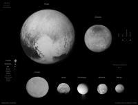
And that same webpage provide a new diameter value for Pluto, bringing Pluto back at the top of the list in the KBO family.
(The statement for the diameter of Pluto is 2,370 kilometers, Charon get 1208 km, for Nix there's an estimate of 35 kilometers, and Hydra at 45 kilometers.)
Posted by: climber Jul 13 2015, 05:40 PM
Much more details here! This looks like giant dark sand dunes.
Posted by: blake Jul 13 2015, 05:42 PM
These two sources don't seem to match up. The article linked above states:
and
EDIT: TheAnt just said the same thing.
Posted by: alex_k Jul 13 2015, 05:43 PM
My processing of 11 of July, 22:22. Factor x3, north is up.
Pluto:
|
Charon:
|
Posted by: volcanopele Jul 13 2015, 05:46 PM
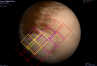
I had completely forgotten about the observation playbook! In that case, I can update my P_LORRI_STEREO_MOSAIC preview to show which frames will be played back this month (using the colors Emily used in her graphic earlier). So the Yellow frames are supposed to be played back Wednesday evening UTC, while the purple frames are supposed to be played back on the afternoon of July 20 UTC.
|
Blake, maybe you're confusing radius and diameter? Diameter = Radius x 2
Posted by: Phil Stooke Jul 13 2015, 05:46 PM
Just playing with contrast in the brighter areas of Pluto and the terminators to make details easier to see.
Phil

|
Posted by: alk3997 Jul 13 2015, 05:47 PM
and
EDIT: TheAnt just said the same thing.
1185km radius x 2 = 2370km diameter
I guess I'm missing what doesn't "add up"?
Andy
Posted by: nprev Jul 13 2015, 05:53 PM
|
|
Astonishing detail on Pluto now, including apparent topography. There seem to be two distinct types of dark terrain. The part facing the camera looks like rugged highlands, but the part rotating into view at 7 o'clock looks flat, featureless, and much darker.
Posted by: JRehling Jul 13 2015, 05:54 PM
To my eye, the dark blotches on the Whale hemisphere seem to have smoothly curving boundaries, while the dark areas on the anti-Whale hemisphere seem to have more irregular boundaries. I'm curious now if that's because they're categorically different or if it's the same materials but differences in topography. (Such as the difference between the jagged coastline of Greece vs. the smooth coastlines of Florida.)
Posted by: Gladstoner Jul 13 2015, 05:58 PM
The same thought occurred to me, but surely those couldn't be dunes....
The prominent 'crater' and a couple other crater-like features look like impact craters that have been etched or 'deconstructed'. Come to think of it, the entire landscape along the lower latitudes appear to be heavily modified in such a manner. It is possible the highly-volatile ices were somehow driven off in these latitudes (leaving behind water ice 'residue'), while remaining intact in the higher latitudes?
Posted by: OWW Jul 13 2015, 06:02 PM
Those grey splotches do look like dunes. We need more pictures to be sure.
Posted by: JRehling Jul 13 2015, 06:03 PM
This is a good observation. I bet when we see some color here, the two kinds of dark terrain end up being not quite the same color. Black and white can hide quite a bit of meaningful differences.
Posted by: mchan Jul 13 2015, 06:09 PM
The vaguely hexagonal feature above the bullseye appears even more crater-like now at the limb.
Posted by: Marvin Jul 13 2015, 06:12 PM
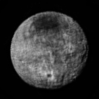
That must be a crater on Charon at the 5 o'clock position. You can even see radial impact ejecta.
The crater on Pluto at the 4 o'clock doesn't show ejecta.
http://www.unmannedspaceflight.com/index.php?act=attach&type=post&id=36814
If they are dunes on Pluto, what would cause them and what would they be made of? 
Posted by: OWW Jul 13 2015, 06:16 PM
Two craters actually. There's a smaller one to the right. But where are all the big impact basins? Charon is remarkably smooth.
Posted by: Steve5304 Jul 13 2015, 06:17 PM
still seeing evidence of fluid having flowed across the surface in the far gone past but we need closer pictures
Posted by: alan Jul 13 2015, 06:17 PM
The dark center and bright ejecta around the 'crater' on Charon reminds me of the craters on some of Uranus's moons.
Posted by: blake Jul 13 2015, 06:21 PM
You're absolutely right.
Posted by: rasun Jul 13 2015, 06:23 PM
There seems to be a bump on the limb at 8 o'clock on this image:
http://www.nasa.gov/image-feature/pluto-s-north-pole-equator-and-central-meridian
If it's a mountain, it could correspond to an irregular, bumpy grey area somewhere between the large black
uniform area and smaller black patch at around 7 o clock position on the latest images
http://www.nasa.gov/sites/default/files/thumbnails/image/nh-7-13-15_pluto_image_nasa-jhuapl-swri.png
Posted by: nprev Jul 13 2015, 06:28 PM
Not seeing any evidence of fluid movement in my view, Steve. That topography looks more sublimation-carved than anything else.
Posted by: Explorer1 Jul 13 2015, 06:32 PM
If those are dunes, how tall could they get considering the surface gravity? Bigger than any on Earth?
Posted by: JRehling Jul 13 2015, 06:34 PM
Pluto's atmosphere contains various compounds of nitrogen, carbon, oxygen, and hydrogen. It is struck by solar UV without protection from a magnetic field. As thin as that atmosphere is, and as weak as the UV is, that will still cause photochemical reactions, even if the rate of those reactions yields a vastly smaller total output than on, say, Titan.
A very small result accumulating for billions of years can still add up. And for a layer of dust to be visible, it does not have to be very thick – a micrometer is potentially enough to alter the visible appearance completely, just as a very thin layer of frost or snow can make something black on Earth appear white.
Titan is theorized to have aerosols drift downward and cover surfaces on the scale of centuries / millennia. Pluto might have a comparable result from a process that's, say, a million times slower, but over a period of time a million times longer.
Posted by: fredk Jul 13 2015, 06:39 PM
Some linear-ish streaking visible near the upper limb:

|
Posted by: Gladstoner Jul 13 2015, 06:52 PM
|
|
Looks like a bad comb-over.
They do remind me of certain streaky features on Triton. The 'head' of the prominent one appears to be very near if not directly on the north pole.
Posted by: Marvin Jul 13 2015, 07:00 PM
@JRehling, thanks for the response. I forgot to think of these bodies using large geological time scales.
Will Grundy, a planetary scientist and mission team member pretty much agrees with you and mentions the role UV light and cosmic rays could have played.
He also told Forbes early this year that:
If New Horizons does see a dune field; and Plutos atmosphere is not nearly thick enough to wind-whip ice particles into dunes at present, then Grundy says that would be a pretty strong indicator that its atmosphere used to be much thicker. Another possibility is that somehow Plutos surface used to have enough liquid nitrogen to have created rippled dunes.
Link to article: http://www.forbes.com/sites/brucedorminey/2015/01/07/why-pluto-still-matters/
Posted by: nprev Jul 13 2015, 07:03 PM
Hmm. Diffidently, I must point out the dunes on 67P C-G. I suppose that the extent of a putative dune field may provide a discriminator between a formerly denser global atmosphere and the effects of local outgassing.
Posted by: rtphokie Jul 13 2015, 07:12 PM
Here's a different view of the fly-by event information from APL's website. It visualizes all those events, instrument by instrument, overlaying DSN communication periods and NASA TV schedule. Filter by instrument in the legend, or search for keywords
http://utprosim.com/newhorizons/index.html
Posted by: ElkGroveDan Jul 13 2015, 07:19 PM
Certainly no doubt about the Copernican-looking impact crater on Charon from these latest images, clearly formed rays and all.
Posted by: squirreltape Jul 13 2015, 07:22 PM
Phil
|
|
Thanks Phil. I can't help but now see Charon's large, dark patch as an impact basin with that 'outer ring' in your processed image. Conjecture I know, but still...

Posted by: FOV Jul 13 2015, 07:37 PM
Less than 500,000 miles to closest approach, according to Eyes on the Solar System.
Posted by: Sherbert Jul 13 2015, 07:41 PM
I am struck by how similar the topology is within the dark areas to that in the bright basin further north. They look "dunish", but the scale suggests, hills and ridges. The majority of the surface seems to be a series of ridges and valleys looping around and the diagram posted sometime back for super volatile deposition matches this terrain. This leads me to think the colour is organics/dust deposited on the surface, maybe as suggested above in only a thin layer of millimetres.
On the latest Pluto image down at 5 O'clock there are three huge mountains, just to the left we can see the beginnings of another dark area which is surrounded by cliffs many kilometres high. On the left rim at the start of the heart plateau we can see a huge elevation change up to the bright plateau. On the edges of the heart plateau as it runs down into the basin again a sharp cliff marks the edge of the bright heart material and the lighter grey of a second step down to the flatter expanse of the temperate latitude basin. [admin edit]
To Charon, the craters hinted at before are quite clear now. Also clear now is how much of a Plateau the Polar ice cap is. That big nick on the limb at about 1 O'Clock continues as a deep valley all the way around the polar cap and its far cliff can be seen at 11 to 12 O'Clock. More wildly it might be speculated that nick is evidence of a subduction zone around the polar cap. I still can't explain why the cap is so dark, how organics and dust could be preferentially deposited at the poles, other than they would be a "cold spot" for concentrating any freezing volatiles. This implies Charon has or once had a significant atmosphere, either its own or what it has pulled off Pluto. It may not have large numbers of craters, but it appears to be a gnarly and very rugged world.
Posted by: stevelu Jul 13 2015, 07:46 PM
So exciting...!
Curious about something: I'm looking at Bill Harris' post on the hi-res coverage http://www.unmannedspaceflight.com/index.php?showtopic=8047&view=findpost&p=223020
(quick link to image here: http://www.unmannedspaceflight.com/index.php?act=attach&type=post&id=36806 ).
The long diagonal path of the highest resolution pictures (which I believe we won't see until the Fall) appears to run "off" the illuminated portion of Pluto just as it gets to the dark southeast edge of the "heart" (see the map at the top of the image). Does that mean that that part of the surface will be in darkness when the images are taken? If so, what is the anticipated result? Or is that just a byproduct of the available rough Pluto image with the correct orientation?
I've seen the discussions of resolution constraints on the Charon-shine pictures to be taken after closest approach, but this would be a different beast, yes?
Posted by: Mercure Jul 13 2015, 07:56 PM
The New Horizon team was quoted in a tweet as saying that there are signs of "frost transport" in the images coming down. Something like this is probably responsible for the various surface features we now see on Pluto, as predicted earlier: "Occultation studies have shown that there has been a steady increase in Pluto's atmospheric pressure over the past two decades, so concomitant sublimation and recondensation of frost has likely occurred, as predicted by volatile transport models." http://adsabs.harvard.edu/abs/2014EGUGA..16.4595B
Posted by: Habukaz Jul 13 2015, 08:04 PM
I am starting to wonder if Charon has some Triton-esque terrain, too. Take a look..

Not much solid evidence for many well-preserved impact craters, which is interesting.
[admin edit]
Posted by: Sherbert Jul 13 2015, 08:19 PM
Agree. Only evidence for a few really big ones. That may be resolution or the smaller ones have been covered over or changed by resurfacing events.
Posted by: Superstring Jul 13 2015, 08:31 PM
Charon does look like a Uranian moon from this resolution. We already know it's similar in size and density as well. It would be wonderful if closeup images of Charon tell us more about them.
Posted by: Sherbert Jul 13 2015, 08:48 PM
Just looked at the latest Charon image again and that "crater" at 6-7 O'Clock appears to me to have a plume of darker material in the direction of the limb and a generous observer might say a smoke trail similar to a volcano can be seen. Impact crater or Caldera, the old question when looking at lower resolution images, even higher ones from Ceres are not conclusive. While in such an extravagantly, unfounded, speculative vein, the vast long Chasm running from 4 to 6 O'Clock, a rift valley? Are there, or were there, continents of Water Ice moving on a mantle of slush made up of super volatiles. At this point Charon is turning out to be a real conundrum. Pluto seems to fit the favoured theoretical models quite nicely, nobody seems to have a good handle on what's going on at Charon.
Posted by: Ian R Jul 13 2015, 08:52 PM
I think Charon's going to be the biggest surprise from this flyby. I may be wrong, but perhaps we're looking at an icy version of Io here.
Posted by: Sherbert Jul 13 2015, 09:12 PM
It may not be now, but before the two bodies became tidally locked, that is plausible I suppose. That might mean that what look like impact craters on Pluto might be ancient Calderas. especially the big circular features we saw on the Charon facing face a couple of days ago.
EDIT: It might also explain why Charon is so uniformly "coloured" and the darkness of the polar cap.
Posted by: Bjorn Jonsson Jul 13 2015, 09:18 PM
Charon looks somewhat similar to Uranus' moons, at least at this resolution. The chasm seems comparable to features seen on Ariel and Titania.
I can't see anything plume-like anywhere.
Meanwhile, on Pluto in the latest image (the one obtained at a distance of 2.5 million km), some of the terrain in the lower half of the image and left of center (at approximately 7 o'clock where there are alternating patches of bright and darker terrain) is starting to remind me a bit of the weird looking terrain seen in hi-res images of Mars' polar regions ("Swiss cheese features") where sublimation is a significant process. The only problem is that the Martian features aren't big and wouldn't even be close to visibility at the resolution of the most recent NH Pluto image.
Posted by: PDP8E Jul 13 2015, 09:19 PM
Its amazing what you can do when if you write scripts (and get out of work early!)
Here are the 2nd set of images from July 11, 2015
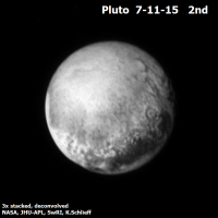
|
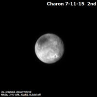
|
Posted by: Bjorn Jonsson Jul 13 2015, 09:27 PM
Here is yet another version of my map of Pluto, this time incorporating the recently released image that was obtained at a range of 2.5 million km (the one that can be found http://pluto.jhuapl.edu/News-Center/News-Article.php?page=20150713 at the NH website). Apparently it was obtained on 2015-07-12 at 08:46. As usual, longitude 0 is at the left edge of the map.
|
The map now has much better coverage of parts of the terrain that will be imaged at high resolution tomorrow, including the northeast half of the bright region near the center of the map.
Posted by: volcanopele Jul 13 2015, 09:44 PM
Thanks for that map. The bright terrains near the equator definitely look like the patchy ice cap margins we saw at Triton.
Posted by: gpurcell Jul 13 2015, 09:45 PM
Given that big and uneroded crater on Charon, I suspect it will end up being a heavily cratered body with limited to no resurfacing that looks rather similar to Oberon.
Posted by: Sherbert Jul 13 2015, 10:01 PM
I have circled the feature on Charon in this image. It has to be speculation at these resolutions, but one also never knows. Personally, it looks very much like a textbook impact crater, but the heat generated must have resulted in some Cryovolcanic activity.
https://www.flickr.com/photos/124013840@N06/19663519412/in/dateposted-public/
Posted by: JRehling Jul 13 2015, 10:04 PM
I wonder if Charon has a mainly-ancient surface with most of its internal heat having vented through the north polar area, just as Enceladus has a mainly-ancient surface with most of its internal heat venting near its south pole.
It seems like too much of a coincidence for Charon's biggest impact basin to have hit its north pole so squarely, so I would guess that the dark spot is volcanic. Another possibility is that it is impact-related and some sort of tidal dynamic moved the rotational pole from another place to that location. Or, it could be purely the result of volatile transport.
Posted by: nprev Jul 13 2015, 10:06 PM
Obviously there must have been some local melting after the impact, but impossible to say if cryovolcanic activity would result. Much better imagery will be required to determine that.
Posted by: Phil Stooke Jul 13 2015, 10:10 PM
I would prefer to bet on a climate origin of the dark spot. As Charon rotates at the current season, the dark spot occupies most of the area that is permanently illuminated and therefore a bit warmer than lower latitudes. Any ice (whatever its composition) which can sublime off that region and condense further south will be removed. As seasons change the dark spot may expand and contract, possibly leaving some of those concentric dark fringes.
Phil
Posted by: volcanopele Jul 13 2015, 10:21 PM
Charon could have reoriented so that a large impact basin could shift to one of the poles. IIRC, that's one of the theories for why Enceladus's plumes are at the south pole (the basin they're in reoriented so that it's at the south pole)
Posted by: titanicrivers Jul 13 2015, 10:22 PM
I may be mistaken did I hear from todays media briefing there a less than expected lower atmospheric density and greater ionized Nitrogen further out from Pluto? I wonder how this fits with Plutos seasonal atmospheric behavior as measured by past and recent star occultation data (suggesting the atmospheric density is still increasing). To expand on Mercures post #90, the paper of Olkin and Young http://arxiv.org/abs/1309.0841 and Emilys nice discussion here http://www.planetary.org/blogs/emily-lakdawalla/2013/09051420-plutos-atmosphere-does-not-collapse.html?referrer=https://www.google.com/ are 2 years old but are likely to be refined, constrained or refuted in the next few weeks of observations. Also one wonders if the equator looks different because it has been facing the sun for some 40+ years during the perihelion portion of Plutos orbit.
Posted by: EDG Jul 13 2015, 10:30 PM
Is that really a "polar cap" we're seeing on Charon, or is it a block of dark terrain that happens to be at the north pole? The edges of it look suspiciously angular to me in the highest resolution image, as if it's bounded by faults (a la Ganymede Dark Terrain, or one of those patchwork blocks on Miranda).
And yeah, as soon as I saw Charon at higher resolution I was reminded of Oberon and Titania!
Posted by: ngunn Jul 13 2015, 10:32 PM
It might be difficult for polar flops to occur on a body already so egg-shaped due to tidal forces. (I have no theories at the moment - just looking at the pictures.
)
Posted by: volcanopele Jul 13 2015, 10:38 PM
Is it very egg-shaped though? Not sure what the expected tidal bulge on Charon is supposed to be.
Posted by: Habukaz Jul 13 2015, 10:47 PM
One science team member refers to the large crater as "https://twitter.com/Alex_Parker/status/620383062677942272", and that large crater could indeed be relatively new.
Here is Ceres, for the most part a heavily cratered body, at a slightly lower resolution: http://dawnblog.jpl.nasa.gov/wp-content/uploads/2015/02/Ceres_OpNav3_MPS_sm.gif
I am not sure how well the viewing geometries compare (though both disks are close to full phase). There is one place on the Cerean disk that you can see craters: the bottom half, and there you can see many of them. So why don't we see more similarly obvious crater candidates on Charon in a large area around the big bright crater?
There is definitely one such candidate just above and to the right of it; but given how obvious the big crater is, I'm surprised we don't see more obvious craters elsewhere. There is that other really obvious crater candidate much further north, so latitude does not appear to be able to explain it all, as far as viewing geometry goes (though it doesn't actually look that much like a crater in the last release - false positive?). Given that both features are obvious candidates even as Charon has rotated significantly indicates that longitude cannot explain it all, either.
I suspect many craters on Charon have been significantly eroded - perhaps by freezing-thawing cycles and/or thermal stress due to the Pluto system's elliptical orbit around the sun. Erosion could explain why not more craters are obvious from this vantage point.
I think we should know more in http://www.nasa.gov/press-release/nasa-announces-updated-television-coverage-media-activities-for-pluto-flybyfrom now. Then we might see an image of Charon where it is 170 pixels across.
Posted by: Yadgar Jul 13 2015, 10:55 PM
Hi(gh)!
I haven't measured Charon as thoroughly and not in the latest images but I have usually gotten values of 590-600 km. This isn't very far from the SPICE value (605 km).
You are aware that you are always looking at less than 50 % of its surface when viewing a spherical object? So the distance from limb to limb measured from photographs would always be somewhat smaller than the actual diameter - the closer, the smaller. The results closest to the real value should be obtained when viewing from a great distance and using a high magnification...
See you in Khyberspace!
Yadgar
Posted by: Gladstoner Jul 13 2015, 11:02 PM
The cratering record may be quite different on Pluto & Charon than what we've seen on other bodies. If the massive impact that formed the Plutonian satellite system occurred after the late heavy bombardment period (Nice model), or even in the late stages, there may not have been enough impactors to saturate the surfaces. It will be interesting to see if there are relatively few craters on an otherwise ancient surface of Charon.
With Pluto, on the other hand, other processes may have altered the cratering record, so all bets are off....
Posted by: MahFL Jul 13 2015, 11:14 PM
NH has passed the 400,000 mile mark now. LORRI is taking pics.
Posted by: djellison Jul 13 2015, 11:17 PM
Pedantic note.... whilst Ralph and Alice are not acronyms... LORRI is.
Posted by: Hungry4info Jul 13 2015, 11:27 PM
I took Bjorn Johnson's (awesome) map from http://www.unmannedspaceflight.com/index.php?s=&showtopic=7986&view=findpost&p=223126 and used a template based off the image in http://www.unmannedspaceflight.com/index.php?s=&showtopic=7970&view=findpost&p=221207 to produce a map comparison.
I have to admit I'm a bit surprised at how well it matches.

|
Posted by: Phil Stooke Jul 13 2015, 11:28 PM
Yadgar: "The results closest to the real value should be obtained when viewing from a great distance and using a high magnification..."
So, pretty much what LORRI has in fact been doing!
But Yadgar, make a sketch of the geometry you are describing. If you project the two tangents out to the distance of the centre of the body you are measuring... the angle plus that distance give you a diameter larger than the true value, not smaller.
(Presumably, if you forget the fact that the limb is not at 90 degrees from the line of sight, you would also forget to correct for the change in distance of the apparent limb!)
Phil
Posted by: alan Jul 14 2015, 12:15 AM
Looking at the color image Pluto appears redder to my eyes from the mid-latitude gray terrain and farther north.
And taking another look at the Triton images I don't see any craters visible until around closest approach, although with it retrograde orbit which is decaying, Triton may have been geologically active more recently than Pluto.
I suspect the impact that formed or captured Charon would have happened before the instability in the Nice model when the relative velocities were smaller.
Posted by: Marvin Jul 14 2015, 12:18 AM
I found this interesting article regarding craters on Pluto and Charon, originally published in Icarus Jan. 2015.
Their models suggest that Kuiper Belt Objects will have a different crater pattern than moons around, say Jupiter or Saturn.
For one thing, primary craters on Pluto and Charon will have a smaller diameter. For example, starting with a 1km diameter impactor:

|
The authors attribute this to the "gravitational focusing that may occur due to a large central body".
Their models also predict:
- Ejecta from Pluto and Charon escape more efficiently from the combined system, relative to ejecta from a satellite in orbit around a giant planet, due to the absence of a large central body.
- We estimate that Kuiper Belt Objects (KBOs) with diameters larger than 1 km should strike Pluto and Charon on (nominal) timescales of 2.2 and 10 million years, respectively.
So there should be some craters, but they will be smaller. It will be interesting to see how closely their current models match this strange region of the Solar System.
Full article: http://www.sciencedirect.com/science/article/pii/S0019103514003066
Posted by: alan Jul 14 2015, 12:20 AM
EDIT: It might also explain why Charon is so uniformly "coloured" and the darkness of the polar cap.
I wonder if they are calderas are they darker because the erupted material is darker or could the lower elevation be acting as a trap for dark dust or sand.
Posted by: PDP8E Jul 14 2015, 12:47 AM
This image was just posted on the NH SOC site.
As you can see the perspective has changed. NH is crossing in front of the pole.

|
Posted by: tedstryk Jul 14 2015, 01:40 AM
Wrote down my own ramblings on the encounter from the SOC http://planetimages.blogspot.com/2015/07/reflections-on-flyby-my-personal.html
Posted by: kap Jul 14 2015, 01:46 AM
Looking at this map: http://www.unmannedspaceflight.com/index.php?act=attach&type=post&id=36806 it looks like a lot of the high res imagery will be of the "heart" which doesn't yet appear to have nearly as many surface features as other areas. There will be some good shots of the border between the heart and the whale though. Does anyone know how the flyby was planned? Is it just based best logistics for the trajectory, or were the Hubble maps used? It makes sense that they would target the high albedo areas, but there was an awful lot of interesting stuff on the hemisphere that is turning away from us now.
-kap
Posted by: JRehling Jul 14 2015, 01:50 AM
If there were an objective scale for "interestingness" and someone had posted odds on Pluto's interestingness, the people who bet high would have won.
Triton was always the comparison case, and Triton's pretty interesting in its own right, but Pluto is looking very interesting without being a Triton clone. Or, at least it's hard to tell how much the things we are seeing are like Triton. There are signs of Titan, maybe signs of Mars.
I keep seeing these images and imagining Wayne and Garth from Wayne's World saying, "We're not worthy!"
Posted by: kap Jul 14 2015, 01:53 AM
Yes, I was expecting (for not particular reason) that the terrain would be a lot more uniform, so I was much less concerned about only imaging one hemisphere in great detail than I am now. We may need to launch a follow-up pretty quickly
I'm watching Nasa's Eyes now, we are getting a lot of Alice measurements.
-kap
Posted by: JRehling Jul 14 2015, 01:56 AM
A major planning consideration was to have Charon in the right position to light up the "far" side of Pluto with Charonshine. That determines the state of rotation of Pluto at flyby time. I'm not sure about the choice of longitude to overfly, but that was in large part a blind guess, anyway.
Posted by: gpurcell Jul 14 2015, 02:00 AM
I think the high res imaging path is just about perfect, actually. I really like that we'll get the interface between the heart and the darkest material.
Posted by: Phil Stooke Jul 14 2015, 02:05 AM
"A major planning consideration was to have Charon in the right position to light up the "far" side of Pluto with Charonshine. That determines the state of rotation of Pluto at flyby time. I'm not sure about the choice of longitude to overfly, but that was in large part a blind guess, anyway. "
The desire for a double occultation would have superseded both of those considerations. Then let the Charonshine fall where it may.
Phil
Posted by: PDP8E Jul 14 2015, 02:12 AM
Hey Phil,
In the image I post above, think of it as an analog clock, is the limb from about 1:00 to 4:00 lit up by Charonshine?
Karle
Posted by: ZLD Jul 14 2015, 02:12 AM
Well this is quite interesting. In the http://pluto.jhuapl.edu/soc/Pluto-Encounter/view_obs.php?image=data/pluto/level2/lor/jpeg/029899/lor_0298996724_0x630_sci_1.jpg&utc_time=2015-07-12%3Cbr%3E08:46:45%20UTC&description=OpNav+Campaign+4%2C+LORRI+1X1&target=PLUTO&range=2.5M%20km&exposure=100%20msec, I think (dangerous for me, I know) we may be seeing some atmospheric effects here at the lower and right edges.
-----------------------------------
2015-7-12 (S1) Pluto blink
-----------------------------------

|
(click to animate)
And here is the processed still frame.

|
Posted by: Gladstoner Jul 14 2015, 02:15 AM
Indeed. Not only will it capture some heart (1) and whale terrain (2), it will cover some of the mottled/swirly stuff (3) and the relatively smooth northern 'cap' (4).

|
I do wonder if the mosaic will be adjusted slightly southward to capture more of the whale terrain.
Posted by: Phil Stooke Jul 14 2015, 02:17 AM
I don't think so. C-shine will be very faint. To see it at all we would need a long exposure, overexposing the rest of the disk.
Phil
In the image I post above, think of it as an analog clock, is the limb from about 1:00 to 4:00 lit up by Charonshine?
Karle
Posted by: centsworth_II Jul 14 2015, 02:20 AM
Posted by: atomoid Jul 14 2015, 02:22 AM
just saw a posting of an old 1979 painting of pluto on the https://twitter.com/newhorizons2015 thats really quite amazing.
The whole image is at http://www.cosmographica.com/spaceart/pluto-predicted.html
Posted by: nprev Jul 14 2015, 02:23 AM
I'm hard pressed to think of a trajectory that would provide better coverage of a greater diversity of terrain as well.
I think that we should give the mission planners that have lived and breathed this mission for years the benefit of the doubt, eh?
Posted by: Tom Tamlyn Jul 14 2015, 02:26 AM
Ted, that's a http://www.unmannedspaceflight.com/index.php?s=&showtopic=7986&view=findpost&p=223158about your personal history with Pluto.
Phil, thanks for posting that http://www.unmannedspaceflight.com/index.php?s=&showtopic=7986&view=findpost&p=223069 I'm a fan of "fun facts to know and tell," and that one's a gem.
Posted by: kap Jul 14 2015, 02:36 AM
I think that we should give the mission planners that have lived and breathed this mission for years the benefit of the doubt, eh?
Don't get me wrong, I think we are going to get amazing data, I probably just have a 'grass is always greener' feeling going on. In a perfect world, we could map the whole new world in high resolution, but we don't live in such a world and what we get will greatly advance our knowledge. Also watching the Eyes preview, there are several sweeps of the LORRI to other interesting areas, they just aren't included in the initial downlink.
-kap
Posted by: Aldebaran Jul 14 2015, 02:37 AM
Phil, thanks for posting that http://www.unmannedspaceflight.com/index.php?s=&showtopic=7986&view=findpost&p=223069 I'm a fan of "fun facts to know and tell," and that one's a gem.
Well now I know why everybody mispronounces Charon. Being interested in Greek mythology, it clashed when people always pronounced it Sharon. Interesting story.
Posted by: Phil Stooke Jul 14 2015, 02:42 AM
Ted, nice story - but I think you mean 56 years since Luna 3!
Phil
Posted by: alk3997 Jul 14 2015, 03:32 AM
Below are the three Pluto images from 7/12/2015. They have been enlarged 2x.
There is only 30 seconds between each image, so not surprisingly there is no change between the three other than Pluto's very very slight rotation (maybe).
The 2 o'clock position circular feature continues to look to me as a crater that froze before it had a chance to fully form. Then other times it looks like a large mountain with a depression below it extending quite a ways.

|
Hopefully everyone knows by now that the best is yet to come...
Andy
Posted by: abalone Jul 14 2015, 03:40 AM
Looks like some of the dark areas are elevated terrain
Release Date: July 13, 2015
http://pluto.jhuapl.edu/Multimedia/Science-Photos/pics/7-13-15_Pluto_image_NASA-JHUAPL-SWRI.png

|
Posted by: fredk Jul 14 2015, 03:41 AM
Update of "map animation" to the latest image:

|
I guess this will be the last update before we see a huge jump in resolution!
Posted by: PDP8E Jul 14 2015, 03:44 AM
July 13, 2015 11:45 pm Eastern Time Zone in the USA
250,000 miles to go (the approximate distance to our Moon)
8 hours to closest approach ( 31,000 mph closing speed)
unbelievable!
Posted by: ZLD Jul 14 2015, 04:30 AM
NH is now completely within the perigee of the Earth's Moon at < 225,309mi.
Posted by: Explorer1 Jul 14 2015, 04:46 AM
Just over 1 light second. EOTSS shows observations of the small moons proceeding one by one.
Posted by: alex_k Jul 14 2015, 04:49 AM
Pluto, 12 of July 08:45, factor x3.

|
Charon, 12 of July 08:50, x3.

|
Posted by: Explorer1 Jul 14 2015, 05:56 AM
Turning towards Earth now. That's gotta be the 'insurance' data coming in now, right?
Posted by: John Broughton Jul 14 2015, 06:13 AM
I've modified a capture from the approach animation to show a gibbous-phase Pluto illuminated by Charon alone during the solar eclipse. The only other possible light source will be a ring of light scattered forward by the exosphere at the limb, so that might be the best opportunity to see the Charon-facing side again, in addition to the otherwise hidden southern hemisphere.
|
Regarding the trajectory design, the solar and radio occultations for both bodies was no doubt a primary objective and probably ruled out a close approach pass on the Charon-facing side.
Posted by: Req Jul 14 2015, 06:50 AM
This page is nice for keeping up with what's going on, you can just refresh it if you don't want to scroll around to find where you are:
http://pluto.jhuapl.edu/Mission/The-Flyby.php
Edit:
And of course anybody who is keeping up with this thread should have this open if they can:
http://eyes.jpl.nasa.gov/eyes-on-pluto.html
Posted by: climber Jul 14 2015, 07:27 AM
Currently 7 DSN antenas pointing in NH direction
Posted by: Gavin Eadie Jul 14 2015, 07:30 AM
I thought that was last night .. four long "fail safe" comm sessions. Plus, these are brief earth pointing periods, enough for some engineering t/m perhaps?
Posted by: paraisosdelsistemasolar Jul 14 2015, 07:32 AM
Again, the New Horizons image database has been fixed. Now you can sort correctly the images by distance. The address is http://nchazarra.duckdns.org/db/
There are around 20 fields duplicated. I will be fixing that later today. Now the script checks if there is new images every hour.
Posted by: climber Jul 14 2015, 07:44 AM
Phil
Same thing happened to me at Apollo 11 spashdown. At one stage dad told me to go to bed...never forget...
Posted by: MahFL Jul 14 2015, 08:03 AM
I got up at 4 am to enjoy the encounter. It's a once in a life time chance.
Posted by: lollipop Jul 14 2015, 08:15 AM
Broadcasting the signal for the radio occultation experiment
Posted by: climber Jul 14 2015, 09:14 AM
http://pluto.jhuapl.edu/Mission/The-Flyby.php
Edit:
And of course anybody who is keeping up with this thread should have this open if they can:
http://eyes.jpl.nasa.gov/eyes-on-pluto.html
Screen sharing between Eyes/TheFlyby/UNMSF and tweeter on the Ipad... I'm ready for the ride...
Posted by: Daniele_bianchino_Italy Jul 14 2015, 09:59 AM
Fantastic images guys,
this is my precise 6 km/pixel collage (5.95 exactly) For compare Pluto-Charon and other bodies of the Solar System.
I'm enthusiastic.

|
Posted by: Req Jul 14 2015, 10:04 AM
I think Charlie Bolden is live on NASA TV as of a couple minutes ago, not sure.
http://www.ustream.tv/NASAHDTV
Posted by: OWW Jul 14 2015, 10:21 AM
Charles Bolden: "Pluto is rich in reds". Maybe he has already seen a certain color picture?
Posted by: neo56 Jul 14 2015, 10:25 AM
My take on LORRI pictures of 11 July, 22h23 UTC:
https://flic.kr/p/vXa8Xu
https://flic.kr/p/v3CBNk
Posted by: MahFL Jul 14 2015, 10:26 AM
It's actually been known for decades Pluto was reddish. Also a color picture has already been released.
Posted by: climber Jul 14 2015, 10:49 AM
1 hour to CA.
Posted by: JRehling Jul 14 2015, 10:56 AM
If you were on New Horizons right now, Pluto would appear 7 times the size of a Full Moon, and you'd be frozen and dead in airless space. Thank you, New Horizons, for making the trip for us!
Posted by: Req Jul 14 2015, 11:02 AM
Youtube link for NASA TV incase the ustream link I posted a few posts up cuts out. I've found it's wise to have 2 or 3 open(and mute all but 1), at least for rocket launches.
https://www.youtube.com/watch?v=OX9I1KyNa8M
And then the actual NASA TV link, for a third source - I've found this is usually the first one to cut out:
http://www.nasa.gov/multimedia/nasatv/
Posted by: climber Jul 14 2015, 11:07 AM
Crossing the orbit of Earth's geostationary satellites...well, you know what I mean.
Posted by: anticitizen2 Jul 14 2015, 11:10 AM
Teaser of the main release
redits: NASA/JHUAPL/SWRI

|
Posted by: pitcapuozzo Jul 14 2015, 11:10 AM
This is it! July 13th @ 4 pm EDT

|
^^ ninja'd.
Posted by: Habukaz Jul 14 2015, 11:11 AM
There be craters.
But ehh, isn't that roughly as big as Pluto should appear in that image (EDIT: yes it is)? How is it a teaser?
https://instagram.com/p/5HTXKMoaFL/?taken-by=nasa, by the way.
Posted by: climber Jul 14 2015, 11:13 AM
Nice
Posted by: JRehling Jul 14 2015, 11:20 AM
It looks like the heart is a bleeding heart!
Posted by: Burmese Jul 14 2015, 11:23 AM
Well, NASA posted that on Instagram as a 'sneak peek' ahead of posting it on their official site so Teaser is a suitable title, I imagine.
Posted by: nprev Jul 14 2015, 11:28 AM
NASA TV program placard now up: "New Horizons Mission Celebration Arrival At Pluto" (their italics).
How many years we've waited to see that.
Posted by: 4throck Jul 14 2015, 11:30 AM
Looks like a filled depression...
Posted by: Mercure Jul 14 2015, 11:31 AM
|
|
^^ ninja'd.
That's the Kodak moment right there, the image that will be on all the front pages tomorrow, and what a fantastic shot it is, great angle with the white area surrounded by all sorts of darker hues and shapes. Congratulations to NASA, the NH team, the US and all of us here on planet Earth: we finally had a look at all of our neighbourhood!
Posted by: nprev Jul 14 2015, 11:33 AM
Charon about to be eclipsed by Pluto from NH's viewpoint.
Posted by: Aldebaran Jul 14 2015, 11:35 AM
It will be good to see the first high resolution MVIC picture.
Posted by: Bjorn Jonsson Jul 14 2015, 11:39 AM
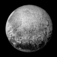
The bright area looks remarkably smooth at this resolution but it apparently has one crater close to its center. And one thing is obvious now: Pluto is more cratered than Triton - but the craters are nevertheless relatively few.
Posted by: kap Jul 14 2015, 11:41 AM
http://s13.postimg.org/ivzqpwa7b/Pluto_Wide.png
It looks like the high res imagery will reach the feature that I've marked here as "Chasm?" but will we also get the crater looking feature in high res or is it outside our range?
-kap
Posted by: Bjorn Jonsson Jul 14 2015, 11:49 AM
Moment of closest approach: NOW!
Posted by: marsbug Jul 14 2015, 11:50 AM
Closest approach, looking at Charon!
Posted by: nprev Jul 14 2015, 11:51 AM
Bill Nye in the front row cheering! 
Posted by: nprev Jul 14 2015, 11:57 AM
End of NASA TV C/A coverage. Next up: Press briefing w/image release.
Posted by: Julius Jul 14 2015, 12:01 PM
Welcome to Pluto!
Posted by: kap Jul 14 2015, 12:02 PM
Looks like the Charon-shine images are being taken right now.
-kap
Edit: looks like they timed it so Pluto is about the width of Ralph's field of view for this pass.
Posted by: craigmcg Jul 14 2015, 12:03 PM
Anyone else wish that we could have heard what the speakers were saying instead of that NASA media guy telling how exciting it was?
Posted by: Webscientist Jul 14 2015, 12:04 PM
Great view!
At first glance, the bright heart reminds me of a frozen sea because it seems uniform and relatively smooth.
Posted by: Daniele_bianchino_Italy Jul 14 2015, 12:08 PM
Momentanean modified compare, 6 Km/pixels
Daniele
|
Posted by: FOV Jul 14 2015, 12:11 PM
I like the location of that prominent "bullesye" crater that looks to be near the transition of darkest to a less dark region.
ps I love the "heart" thing, you can't buy that kind of pr, Alan must be over the moon, er I mean Pluto!
Posted by: Explorer1 Jul 14 2015, 12:11 PM
Swear jar full again...
Posted by: Habukaz Jul 14 2015, 12:13 PM
It looks a bit like there is Triton-esque terrain to the left. Did we me 'miss out' on the parts of Pluto that look the most like Triton?
Posted by: Mr Valiant Jul 14 2015, 12:15 PM
Agreed, some of the most sublime dialogue is via the Flight Director and team, be it UMSF, Apollo or Shuttle.
Still, fascinating stuff, so much to take in at one gulp. To hark back to when I was a child (1960`s), no one could have predicted what
we are seeing right now.
Go New Horizons - Go.
Posted by: nprev Jul 14 2015, 12:16 PM
Presser on now, reveal of the 'preview' image!
Posted by: Daniele_bianchino_Italy Jul 14 2015, 12:17 PM
do not see many similarities with Triton, it seems different from any others body of the solar system..
the " white heart " resemble an antique lake basin dissolved
Posted by: xflare Jul 14 2015, 12:18 PM
I think the only thing that will ever look like Triton IS Triton lol
Posted by: Drkskywxlt Jul 14 2015, 12:21 PM
EOTSS says "Target Earth", so I imagine that's the radio science experiment looking at the atmosphere?
Posted by: kap Jul 14 2015, 12:23 PM
Ok, tell me I'm crazy but does it look like the large chasm right above/left of the heart opens into a huge alluvial fan? I've marked it on the image here:

|
-kap
Posted by: Antdoghalo Jul 14 2015, 12:23 PM
History in the making, and we are greeted with a heart! 
Posted by: nprev Jul 14 2015, 12:23 PM
Hope that they'll talk a bit about the Pluto & Charon radio occultation experiments. Those should be received in just a few hours, well in advance of the image playbacks.
kap, I'm not seeing your alluvial fan. Q&A starting re image details.
Posted by: JRehling Jul 14 2015, 12:26 PM
The next step is the stars.
Posted by: nprev Jul 14 2015, 12:28 PM
Emily just asked about color imagery and if any atmospheric phenomena have been captured.
Posted by: Nafnlaus Jul 14 2015, 12:32 PM
Still lots of planets left to explore in our own system
What I'm most struck by in the image is how, while there's a few high relief craters, most craters are so flat as to be barely visible. I hesitate to use the word "eroded", but that's what it reminds me of. Or "filled".
But maybe it's a perspective or lighting thing, or perhaps my expectations are tuned to the appearance of craters on smaller bodies than Pluto.
Posted by: alk3997 Jul 14 2015, 12:32 PM
Below is a close-up of the transition area near the Whale's Head. It's interesting to look at the crater types and numbers. It appears there are large areas of smooth areas without craters and then some Europa-type craters as well as what appears to be some cracks in the ice.

|
This is the press release image with 4x magnification and some sharpening.
Andy
Posted by: kap Jul 14 2015, 12:35 PM
|
|
This is the press release image with 4x magnification and some sharpening.
Andy
The craters also appear to have a weird double ring / donut shape. There is the really prominent one in the center of your zoom and then the much larger one on the limb at the top left (which I think is one of the large craters we saw in earlier images?). The horizontal lines are also interesting.
-kap
Posted by: Habukaz Jul 14 2015, 12:41 PM
Ok, it would appear that Charon has https://twitter.com/rebeccamorelle/status/620935428066164736. Hope we can see the latest image soon.
Posted by: um3k Jul 14 2015, 12:45 PM
Well, there is one other thing: a moldy cantaloupe!
Posted by: Drkskywxlt Jul 14 2015, 12:45 PM
Pluto atmosphere radio occultation about to begin.
Posted by: alk3997 Jul 14 2015, 12:54 PM
This "nub" is different. There is a crater in front of it. But, with very little analysis, it seems like the nub's shadow isn't matching the solar direction or it's larger than it should be based on the surrounding terrain.

|
Andy
Posted by: xflare Jul 14 2015, 12:55 PM
Did anyone catch what Alice Bowman said about the data recorders a few minutes ago? Something about having early data saying they were filling.. audio cut out.
Posted by: alk3997 Jul 14 2015, 12:57 PM
Dr. Bowman said that when they received telemetry last night they could see that two of the solid state recorder segments had been filled with data. There are many segments and as data is recorded they will fill-up, as expected.
Andy
Posted by: Req Jul 14 2015, 01:00 PM
New Horizons Mission Celebration – Arrival at Pluto:
http://www.space-multimedia.nl.eu.org/index.php?option=com_content&view=article&id=9505:new-horizons-mission-celebration-arrival-at-pluto&catid=1:latest
Edit:
NASA News Briefing on New Horizon Mission:
http://www.space-multimedia.nl.eu.org/index.php?option=com_content&view=article&id=9506:nasa-news-briefing-on-new-horizon-mission&catid=1:latest
Posted by: Daniele_bianchino_Italy Jul 14 2015, 01:02 PM
Pluto, discovered by Clyde Tombaugh in 1930, Charon in 1978 by James Christy; Clyde and many others would have definitely wanted to see them, but impossible in those time ..
we are lucky, we see them today ..
we can
Daniele
Pluto-Triton 6Km/pixel

|
Posted by: gpurcell Jul 14 2015, 01:04 PM
The most interesting of the craters to me in the magnified picture is the small one on the lower right. It looks like it hit right at the transition and blew the dark material across the transition boundary between the dark and light material.
Posted by: pitcapuozzo Jul 14 2015, 01:09 PM
we are lucky, we see them today ..
we can
Daniele
Jim Christy is well and alive, actually he was at JHUAPL today! Maybe that's not what you meant but to me it sounded like he had died.
Posted by: tedstryk Jul 14 2015, 01:10 PM
Pluto and Triton from the equivalent global color shots from each flyby.
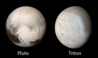
|
Posted by: climber Jul 14 2015, 01:18 PM
Emilly's got the full resolution image: http://www.planetary.org/blogs/emily-lakdawalla/2015/07140911-new-horizons-best-look-at.html?referrer=http://planetary.org/blogs/
Posted by: Req Jul 14 2015, 01:20 PM
NASA News Briefing on New Horizon Mission:
http://www.space-multimedia.nl.eu.org/index.php?option=com_content&view=article&id=9506:nasa-news-briefing-on-new-horizon-mission&catid=1:latest
Posted by: Daniele_bianchino_Italy Jul 14 2015, 01:43 PM
Very Sorry, I meant that Clyde and many others would have definitely wanted to see them, but impossible in those time ..

Posted by: fredk Jul 14 2015, 02:02 PM
Big congratulations to the team for getting us there! Compared to (my somewhat vague memory of) the big planet flyby's, I think we're seeing things develop on a much shorter timescale with Pluto - the rate of increase of the apparent size of Jupiter, say, would've been much slower. So this makes it that much more exciting...
Back to business: Emily asked about colour - I don't recall the response. It appears this morning's release has been colourized with a single hue. Here's the extracted hue channel:
|
Can't wait to see proper colour!
Posted by: John Broughton Jul 14 2015, 02:11 PM
Could this be a large slightly-elongated impact basin with icy ejecta spreading toward the lower right?

|
Charon had to have bounced off somewhere before going into orbit!
Posted by: Bagelvoid Jul 14 2015, 02:16 PM
Clyde is along for the ride!
https://www.google.com.ar/url?sa=t&source=web&rct=j&url=http://www.cnn.com/2015/07/13/us/nasa-pluto-new-horizons-clyde-tombaugh-ashes/&ved=0CB4QqQIwAGoVChMIgtmN5-baxgIVxAqQCh3bvQya&usg=AFQjCNFWDID_rij6kAfkpqaFd6UlggeeBw
Posted by: Habukaz Jul 14 2015, 02:21 PM
The first impression I got by looking at today's release was Mars, in great part due to the colour. Looking forward to pure MVIC colour images (we should have one down with Pluto 480 pixels across on Thursday). MVIC images at similar resolution should look a lot better.
Posted by: Daniele_bianchino_Italy Jul 14 2015, 02:23 PM
https://www.google.com.ar/url?sa=t&source=web&rct=j&url=http://www.cnn.com/2015/07/13/us/nasa-pluto-new-horizons-clyde-tombaugh-ashes/&ved=0CB4QqQIwAGoVChMIgtmN5-baxgIVxAqQCh3bvQya&usg=AFQjCNFWDID_rij6kAfkpqaFd6UlggeeBw
I hope in some way it is there. .
Posted by: Julius Jul 14 2015, 02:24 PM
The highest resolution picture seems to show terrain carved by ice deposition and sublimation. The cratering visible even within the darkest regions seem to indicate whatever formed these must be old.
Climatic processes are at work at pluto judging from the latest picture. We need the close ups at closest approach to really be able to comment upon tectonic structures. I understand Alan Stern when he said he was not sure about tectonic structures on pluto at this point in time.
Posted by: nprev Jul 14 2015, 02:26 PM
Canberra now has two antennas being configured for NH; must be preparing for the radio occultations.
Posted by: Mongo Jul 14 2015, 02:30 PM
A list of scheduled imaging observations with better than 1 km/pixel resolution:
Pluto (LORRI)
July 14 04:13:51 EDT
New Horizons is taking 2 images of Pluto with LORRI from 179248.28 km away at est. resolution 0.89 km/pix.
July 14 04:14:39 EDT
New Horizons is taking 2 images of Pluto with LORRI from 178588.97 km away at est. resolution 0.89 km/pix.
July 14 04:15:27 EDT
New Horizons is taking 2 images of Pluto with LORRI from 177929.68 km away at est. resolution 0.88 km/pix.
July 14 04:16:15 EDT
New Horizons is taking 2 images of Pluto with LORRI from 177270.40 km away at est. resolution 0.88 km/pix.
July 14 04:17:03 EDT
New Horizons is taking 2 images of Pluto with LORRI from 176611.14 km away at est. resolution 0.88 km/pix.
July 14 04:17:51 EDT
New Horizons is taking 2 images of Pluto with LORRI from 175951.89 km away at est. resolution 0.87 km/pix.
July 14 04:18:39 EDT
New Horizons is taking 2 images of Pluto with LORRI from 175292.66 km away at est. resolution 0.87 km/pix.
July 14 04:19:27 EDT
New Horizons is taking 2 images of Pluto with LORRI from 174633.44 km away at est. resolution 0.87 km/pix.
July 14 04:20:15 EDT
New Horizons is taking 2 images of Pluto with LORRI from 173974.24 km away at est. resolution 0.86 km/pix.
July 14 04:21:03 EDT
New Horizons is taking 2 images of Pluto with LORRI from 173315.06 km away at est. resolution 0.86 km/pix.
July 14 04:21:51 EDT
New Horizons is taking 2 images of Pluto with LORRI from 172655.89 km away at est. resolution 0.86 km/pix.
July 14 04:22:39 EDT
New Horizons is taking 2 images of Pluto with LORRI from 171996.74 km away at est. resolution 0.85 km/pix.
July 14 04:23:27 EDT
New Horizons is taking 2 images of Pluto with LORRI from 171337.60 km away at est. resolution 0.85 km/pix.
July 14 04:24:15 EDT
New Horizons is taking 2 images of Pluto with LORRI from 170678.48 km away at est. resolution 0.85 km/pix.
July 14 04:25:03 EDT
New Horizons is taking 2 images of Pluto with LORRI from 170019.38 km away at est. resolution 0.84 km/pix.
July 14 04:25:51 EDT
New Horizons is taking 2 images of Pluto with LORRI from 169360.30 km away at est. resolution 0.84 km/pix.
July 14 04:26:39 EDT
New Horizons is taking 2 images of Pluto with LORRI from 168701.23 km away at est. resolution 0.84 km/pix.
July 14 04:27:27 EDT
New Horizons is taking 2 images of Pluto with LORRI from 168042.18 km away at est. resolution 0.83 km/pix.
July 14 04:28:15 EDT
New Horizons is taking 2 images of Pluto with LORRI from 167383.15 km away at est. resolution 0.83 km/pix.
July 14 04:29:03 EDT
New Horizons is taking 2 images of Pluto with LORRI from 166724.13 km away at est. resolution 0.83 km/pix.
uly 14 06:10:15 EDT
New Horizons is taking 15 images of Pluto with LORRI from 83646.234 km away at est. resolution 0.41 km/pix.
July 14 06:43:00 EDT
New Horizons is taking 23 images of Pluto with LORRI from 56315.602 km away at est. resolution 0.28 km/pix.
July 14 07:17:48 EDT
New Horizons is taking 70 images of Pluto with LORRI from 30003.890 km away at est. resolution 0.15 km/pix.
July 14 07:26:28 EDT
New Horizons is taking 130 images of Pluto with LORRI from 23859.780 km away at est. resolution 0.12 km/pix.
July 14 07:58:30 EDT
New Horizons is taking 60 images of Pluto with LORRI from 15386.759 km away at est. resolution 0.076 km/pix.
July 14 11:04:08 EDT
New Horizons is taking 4 images of Pluto with LORRI from 160954.31 km away at est. resolution 0.80 km/pix.
July 14 11:05:01 EDT
New Horizons is taking 4 images of Pluto with LORRI from 161681.58 km away at est. resolution 0.80 km/pix.
July 14 11:05:54 EDT
New Horizons is taking 4 images of Pluto with LORRI from 162408.88 km away at est. resolution 0.81 km/pix.
July 14 11:06:47 EDT
New Horizons is taking 4 images of Pluto with LORRI from 163136.20 km away at est. resolution 0.81 km/pix.
July 14 11:07:40 EDT
New Horizons is taking 4 images of Pluto with LORRI from 163863.55 km away at est. resolution 0.81 km/pix.
July 14 11:08:33 EDT
New Horizons is taking 4 images of Pluto with LORRI from 164590.92 km away at est. resolution 0.82 km/pix.
July 14 11:41:41 EDT
New Horizons is taking 2 images of Pluto with LORRI from 191887.68 km away at est. resolution 0.95 km/pix.
July 14 11:42:39 EDT
New Horizons is taking 2 images of Pluto with LORRI from 192684.40 km away at est. resolution 0.96 km/pix.
July 14 11:43:37 EDT
New Horizons is taking 2 images of Pluto with LORRI from 193481.14 km away at est. resolution 0.96 km/pix.
July 14 11:44:35 EDT
New Horizons is taking 2 images of Pluto with LORRI from 194277.90 km away at est. resolution 0.96 km/pix.
July 14 11:45:33 EDT
New Horizons is taking 2 images of Pluto with LORRI from 195074.67 km away at est. resolution 0.97 km/pix.
July 14 11:46:31 EDT
New Horizons is taking 2 images of Pluto with LORRI from 195871.45 km away at est. resolution 0.97 km/pix.
Pluto (MVIC)
July 14 07:05:25 EDT
New Horizons is taking an image of Pluto with MVIC Color from 39384.908 km away at est. resolution 0.78 km/pix.
July 14 07:20:16 EDT
New Horizons is taking an image of Pluto with MVIC from 28206.280 km away at est. resolution 0.56 km/pix.
July 14 07:31:05 EDT
New Horizons is taking an image of Pluto with MVIC from 20854.035 km away at est. resolution 0.41 km/pix.
July 14 07:50:47 EDT
New Horizons is taking an image of Pluto with MVIC from 13735.372 km away at est. resolution 0.27 km/pix.
July 14 08:00:41 EDT
New Horizons is taking an image of Pluto with MVIC from 16282.704 km away at est. resolution 0.32 km/pix.
July 14 08:08:13 EDT
New Horizons is taking an image of Pluto with MVIC from 20323.226 km away at est. resolution 0.40 km/pix.
Charon (LORRI)
July 14 04:32:31 EDT
New Horizons is taking 2 images of Charon with LORRI from 178279.45 km away at est. resolution 0.88 km/pix.
July 14 04:33:19 EDT
New Horizons is taking 2 images of Charon with LORRI from 177623.82 km away at est. resolution 0.88 km/pix.
July 14 04:34:07 EDT
New Horizons is taking 2 images of Charon with LORRI from 176968.26 km away at est. resolution 0.88 km/pix.
July 14 04:34:55 EDT
New Horizons is taking 2 images of Charon with LORRI from 176312.76 km away at est. resolution 0.87 km/pix.
July 14 04:35:43 EDT
New Horizons is taking 2 images of Charon with LORRI from 175657.33 km away at est. resolution 0.87 km/pix.
July 14 04:36:31 EDT
New Horizons is taking 2 images of Charon with LORRI from 175001.97 km away at est. resolution 0.87 km/pix.
July 14 04:37:19 EDT
New Horizons is taking 2 images of Charon with LORRI from 174346.67 km away at est. resolution 0.86 km/pix.
July 14 04:38:07 EDT
New Horizons is taking 2 images of Charon with LORRI from 173691.45 km away at est. resolution 0.86 km/pix.
July 14 05:14:42 EDT
New Horizons is taking 6 images of Charon with LORRI from 143819.25 km away at est. resolution 0.71 km/pix.
July 14 06:23:47 EDT
New Horizons is taking 12 images of Charon with LORRI from 88389.251 km away at est. resolution 0.44 km/pix.
July 14 07:43:07 EDT
New Horizons is taking 67 images of Charon with LORRI from 34200.236 km away at est. resolution 0.17 km/pix.
Charon (MVIC)
July 14 07:45:29 EDT
New Horizons is taking an image of Charon with MVIC from 33245.206 km away at est. resolution 0.66 km/pix.
Nix (LORRI)
July 14 04:05:11 EDT
New Horizons is taking 2 images of Nix with LORRI from 156736.78 km away at est. resolution 0.78 km/pix.
July 14 04:05:59 EDT
New Horizons is taking 2 images of Nix with LORRI from 156083.94 km away at est. resolution 0.77 km/pix.
July 14 04:06:47 EDT
New Horizons is taking 2 images of Nix with LORRI from 155431.16 km away at est. resolution 0.77 km/pix.
July 14 05:57:13 EDT
New Horizons is taking 13 images of Nix with LORRI from 66612.933 km away at est. resolution 0.33 km/pix.
July 14 10:55:27 EDT
New Horizons is taking 4 images of Nix with LORRI from 184363.28 km away at est. resolution 0.91 km/pix.
July 14 10:56:17 EDT
New Horizons is taking 4 images of Nix with LORRI from 185044.97 km away at est. resolution 0.92 km/pix.
July 14 10:57:07 EDT
New Horizons is taking 4 images of Nix with LORRI from 185726.69 km away at est. resolution 0.92 km/pix.
July 14 10:57:57 EDT
New Horizons is taking 4 images of Nix with LORRI from 186408.45 km away at est. resolution 0.92 km/pix.
Nix (MVIC)
July 14 07:14:32 EDT
New Horizons is taking an image of Nix with MVIC from 22235.744 km away at est. resolution 0.44 km/pix.
Hydra (LORRI)
July 14 10:44:55 EDT
New Horizons is taking 4 images of Hydra with LORRI from 156723.64 km away at est. resolution 0.78 km/pix.
July 14 10:45:45 EDT
New Horizons is taking 4 images of Hydra with LORRI from 157326.38 km away at est. resolution 0.78 km/pix.
July 14 10:46:35 EDT
New Horizons is taking 4 images of Hydra with LORRI from 157929.86 km away at est. resolution 0.78 km/pix.
July 14 10:47:25 EDT
New Horizons is taking 4 images of Hydra with LORRI from 158534.08 km away at est. resolution 0.79 km/pix.
July 14 10:48:15 EDT
New Horizons is taking 4 images of Hydra with LORRI from 159139.03 km away at est. resolution 0.79 km/pix.
July 14 10:49:05 EDT
New Horizons is taking 4 images of Hydra with LORRI from 159744.70 km away at est. resolution 0.79 km/pix.
July 14 10:49:55 EDT
New Horizons is taking 4 images of Hydra with LORRI from 160351.08 km away at est. resolution 0.80 km/pix.
July 14 10:50:45 EDT
New Horizons is taking 4 images of Hydra with LORRI from 160958.17 km away at est. resolution 0.80 km/pix.
July 14 10:51:35 EDT
New Horizons is taking 4 images of Hydra with LORRI from 161565.95 km away at est. resolution 0.80 km/pix.
July 14 10:52:25 EDT
New Horizons is taking 4 images of Hydra with LORRI from 162174.42 km away at est. resolution 0.80 km/pix.
Posted by: Julius Jul 14 2015, 02:30 PM
The variations of ice deposits on pluto could be related to composition or perhaps more significant local topography that might explain the persistence of the brightest region on the equator.
Posted by: climber Jul 14 2015, 02:36 PM
Hum, not sure. I thing it's done. Have to be sent 4,5 hours earlier.
Posted by: PDP8E Jul 14 2015, 02:40 PM
The first impression I got when viewing the 'teaser' image was that it looked like it was done in 'sepia' mode. The color is very interesting. Hopefully we will get another sample planetoid thing as NH plows ahead thru the Kuiper Belt.
Posted by: Paolo Jul 14 2015, 02:48 PM
plus, NH is unusual in that for the radiooccultation the spacecraft listens instead of transmitting
Posted by: HughFromAlice Jul 14 2015, 02:50 PM
This is a little bit old - in the light of the new higher res amazing pics - but still maybe of interest. I had too much fun working on the image and then colourizing ......so I missed the new pics as I just lost track of time!!
Hᴜɢʜ
.ツ

|
Posted by: Bill Harris Jul 14 2015, 02:51 PM
Yep, colourised. The first thing I did was convert to grayscale.
attachment=36862:plutotritongloco.jpg
I like that presentation. But the South pole of Triton is on it's left, and the North pole of Pluto is on the top.
An alternate treatment would be to orient the Triton image with the pole on top on a basis of similar climatic zones (attached):
--Bill

|
Posted by: nprev Jul 14 2015, 02:52 PM
Oh, duh; didn't realize that. Thanks!
Posted by: 4throck Jul 14 2015, 02:55 PM
High passed and level streched !

|
Posted by: Drkskywxlt Jul 14 2015, 02:56 PM
Yes, both the occultations are over. Charon was around 1410 GMT. Pluto about 1.5 hours earlier.
Posted by: Daniele_bianchino_Italy Jul 14 2015, 03:08 PM
Guys would we NEVER images of Cerbero and Stige?
And the south polar region of Pluto?
M ThankS.
Posted by: Saturns Moon Titan Jul 14 2015, 03:08 PM
The newest pictures are amazing!
What surprises me most is the lack of craters. I was aware that Pluto had an atmosphere that potentially precipitated snow but I expected there to be a similar amount of craters to Mars. I didn't really want to get my hopes up.
But instead it turns out Pluto has only about twenty of thirty craters on the entire approach hemisphere visible from this distance! And the love heart shaped feature is looking far smoother than I expected. I can't wait for the flyby data to come back to Earth!
Posted by: nprev Jul 14 2015, 03:10 PM
Gotta remember that Mars is right next door to the asteroid belt. For that matter, the inner Solar System has a lot more junk than the outer environs, plus much higher potential relative impact velocities.
Posted by: ZLD Jul 14 2015, 03:11 PM
There was an interesting glint off of the terrain near the head of the whale.
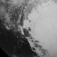
|
Posted by: Charles Jul 14 2015, 03:26 PM
Going back to the Charon side which we will never see again (except in Charon light) I find the terrain extraordinary. Not to get too technical here, but the "wrinkles" look like MC Escher lizards. What are they? More interesting, the feature at 4 o'clock looks very different in this image, compared to others where it looks more crater-like. In the blow up on the far right, I have highlighted something that reminds me of the way Europa's cracks and surface displacements often overlay one another. Is the lighter material (highlighted as yellow) volcanic flows across the dark line (highlighted as red) that extends out from the circular feature? Others have already noted the doughnut-like look of several of Pluto's presumed craters.
--Charles

|
Posted by: climber Jul 14 2015, 03:29 PM
Nice 9throck, you've even got details in the atmosphere

Posted by: ElkGroveDan Jul 14 2015, 03:40 PM
I seriously doubt that.
Posted by: Marvin Jul 14 2015, 03:43 PM
https://www.google.com.ar/url?sa=t&source=web&rct=j&url=http://www.cnn.com/2015/07/13/us/nasa-pluto-new-horizons-clyde-tombaugh-ashes/&ved=0CB4QqQIwAGoVChMIgtmN5-baxgIVxAqQCh3bvQya&usg=AFQjCNFWDID_rij6kAfkpqaFd6UlggeeBw
Indeed.

|
Posted by: kenny Jul 14 2015, 03:43 PM
Stunning and awesome.... both the sublime images of Pluto and the technological achievement.
Exactly 50 years ago on 14 July 1965 US time (15 July UTC) Mariner 4 made its own fly-by of Mars, providing our first close-up views of another planet.
Now New Horizons has completed the survey of all the planets we learned as children. What a project to witness in one lifetime!
Many congratulations to all involved.
Posted by: climber Jul 14 2015, 03:44 PM
I'm seriously joking Dan
Posted by: Marvin Jul 14 2015, 03:45 PM
Yeah, image processing artifact. Didn't they say this morning that the thin atmosphere is basically transparent?
Posted by: 4throck Jul 14 2015, 03:46 PM
Yes, doubtful.
Highpass will bring out ring artifacts, and create the illusion of a brightness along the limb.
On the other hand, the released image is not raw.
Certainly there was a circular selection made around the planet, to bring the lightness of the disk up, while keeping the background of the frame black.
Makes perfect sense for them to do that on an image that most people will see on TV, cellphone, etc, in well lit places.
So it's that selection that you are seeing, not the atmosphere. At least that's my interpretation.
Posted by: Marvin Jul 14 2015, 03:48 PM
|
|
I noticed that too.
But I haven't seen the bright spot in any other image, yet. It could be a hot pixel in LORRI.
You can see this in another LORRI image, right side, middle:
http://pluto.jhuapl.edu/soc/Pluto-Encounter/data/pluto/level2/lor/jpeg/029861/lor_0298614804_0x630_sci_1.jpg
Posted by: hendric Jul 14 2015, 03:52 PM
Sorry guys, had to deal with the police coming to my house because my SWEAR JAR EXPLODED!
Congrats New Horizons team, every day of those ten years was totally worth it!
Posted by: HughFromAlice Jul 14 2015, 03:57 PM
I couldn't resist working on the latest pics just out of interest to see how much I could enhance the surface features to make them a bit clearer.... no pretence at scientific accuracy although the result doesn't look too bad...
Brilliant work by Alan Stern and the team. The realization of such a huge life goal after so many years hard unrelenting effort. What will power!!! Great to see 25% are women. The sooner it is about 50/50 the better.
Hᴜɢʜ
.ツ

|
Posted by: Marvin Jul 14 2015, 03:58 PM
I think I'm seeing many small diameter craters, as predicted by some impact models.
I hope I'm wrong, because a lack of craters would mean an active, dynamic surface.
I'm sure the planetary scientists will be analyzing the data for years. Stay tuned.
Posted by: Marvin Jul 14 2015, 04:05 PM
Brilliant work by Alan Stern and the team. The realization of such a huge life goal after so many years hard unrelenting effort. What will power!!! Great to see 25% are women. The sooner it is about 50/50 the better. Hᴜɢʜ .ツ
[attachment=36876:01HL_201...ehealth3.jpg]
Wow!
It almost has a sense of depth.
Posted by: HughFromAlice Jul 14 2015, 04:19 PM
Thanks Marvin. This wasn't from a raw image so it was basically working on the photo more for my own enjoyment than posting! There are some really talented people on this forum
who do great work - I've learned heaps from them!! It's late in Central Australia and I have to get up early tomorrow!! Hᴜɢʜ .ツ
Posted by: Daniele_bianchino_Italy Jul 14 2015, 04:21 PM
wow..you can in black background?
Posted by: Bjorn Jonsson Jul 14 2015, 04:24 PM
This is a new version of my map incorporating the image obtained at a range of 738,000 km. It's not in color since (as fredk has shown in http://www.unmannedspaceflight.com/index.php?showtopic=7986&view=findpost&p=223272) the image was colorized with a single hue (i.e. clearly not with new MVIC data). Longitude 0 is at the left edge of the map.
EDIT: The color in the image is in fact from a recent MVIC image, it's just very uniform. So the image was not colorized with a single hue.
|
There are some minor feature position discrepancies along the boundary between the new image and the older data. Once I have more hi-res data I'll reproject the older images again, using the higher-res global images (or images where Pluto's limb is visible) as reference.
And here is a rotation movie rendered using this map:
 pluto_rot_20150714_c.mp4 ( 1.93MB )
: 1396
pluto_rot_20150714_c.mp4 ( 1.93MB )
: 1396Posted by: TheAnt Jul 14 2015, 04:29 PM
You're lucky! My swear jar got so overfilled it imploded and created a miniature black hole. The only positive part of the mess it created is that I will not have to vacuum clean this week.

Serious, congratulation to the NH team and thank you 4throck for that image. I take that one as the final impression for this evening and now we can start looking forward to the images and information that will trickle down in days and weeks to come.
And far fewer craters than I expected, you guys were right on that part!
Posted by: Daniele_bianchino_Italy Jul 14 2015, 04:33 PM
|
|
Love this global maps!!
we will have the south pole?
Posted by: dvandorn Jul 14 2015, 04:36 PM
Fascinating!
The main part of the Heart looks for all the world like Greenland, with some "ground" exposed along its northern extent and glaciers covering the remainder. The whole thing looks a lot like a remnant icecap. There is definitely vertical relief to this feature. It also appears that the large, darker features to the left of the Heart (that include the head of the Whale) also form a plateau-like relief feature, in many ways reminiscent of a dark-toned remnant icecap. Maybe a lot of places on Pluto develop icecaps as time goes on, and some of them take longer to lose the deposited ices than others?
Also, throughout the northern plains, I'm seeing large-scale light-toned streaking that looks a lot like the wind streaks I was predicting in my WAG post. I also see one small, suspiciously dark streak-like feature that could be something like the black nitrogen geysers seen on Triton. If so, it's the only suggestion of one of those that I see in the entire image.
I think it will be extremely illustrative to see the surficial details of the "icecap" in the main body of the Heart, since it will likely show details of both ice/frost deposition and erosion. At this resolution it also appears to exhibit streaking or grooving, consistent with the winds that would blow from the most-highly-insolated north polar region towards the shadowed pole. I bet we see indications of different prevailing wind patterns, too, since these will change as Pluto's orientation to the Sun changes.
It'll be interesting to correlate the predominant deposition/erosion patterns to the Pluto system's orientation to the Sun over time, and to its distance from the Sun. I'm certain that, like Earth, one polar hemisphere gets higher insolation than the other due to correlations between aposol/perisol and seasonal tilt.
-the other Doug
Posted by: alk3997 Jul 14 2015, 04:41 PM
...
There are some minor feature position discrepancies along the boundary between the new image and the older data. Once I have more hi-res data I'll reproject the older images again, using the higher-res global images (or images where Pluto's limb is visible) as reference.
And here is a rotation movie rendered using this map:
pluto_rot_20150714_c.mp4 ( 1.93MB )
: 1396Could a reasonable explanation for the crater density and location be that the northern ice sheet is thick enough to cover all of the craters. As the ice sheet melts during the northern summer, the craters are uncovered. What we are seeing in the more chaotic terrain north of the equator is the uncovering of the older surface.
At least one flaw in the theory is that the dark material at the equator should have more craters than it shows so far. It's like something swallows the impacts in the dark areas, although there are a few medium sized craters there.
Andy
Posted by: Phil Stooke Jul 14 2015, 04:42 PM
Playing with contrast selectively across the image.
Phil

|
Posted by: Bjorn Jonsson Jul 14 2015, 05:08 PM
From information on Twitter and some (crude) measurements I did, it seems that the image was in fact colorized using higher resolution MVIC data than we have been seeing until now. But it is surprising to me how uniform the color is.
Posted by: JTN Jul 14 2015, 05:26 PM
No sign yet of the ~170-pixel Charon LORRI image that should have come down in the Fail Safe D downlink yesterday according to http://www.planetary.org/blogs/emily-lakdawalla/2015/06240556-what-to-expect-new-horizons-pluto.html? Or did I miss it?
Posted by: 4throck Jul 14 2015, 05:30 PM
Second that, there's some saturation variation and if you stretch the levels you get some white/pink areas related to different terrains.
Posted by: fredk Jul 14 2015, 05:33 PM
Could you post your colour measurements, Bjorn? It does look awfully uniform.
I'm also intrigued by the resolution. Here's a comparison of the 1024x1024 press image (eg, on the NH site) with the lower-resolution (640x640) "preview" image posted earlier on instagram. I've Lanczos rescaled the instagram pic to 1024x1024, and then both images by 400%, and no other processing whatsoever:

|
The instagram image is https://igcdn-photos-h-a.akamaihd.net/hphotos-ak-xfa1/t51.2885-15/11311925_687877714680167_484233801_n.jpg and the 1024x1024 image is P_LORRI_FULLFRAME_COLOR.png. The instagram image is a jpeg, and appears to show more compression artifacts. But the 1024x1024 image shows some odd diagonal streaking (from the lower left to upper right). Perhaps the result of a rotation to put north up?
The overall impression is that the 1024x1024 image doesn't look much (or any) sharper than the 640x640. So I think we can look forward to better quality versions of this image.
Posted by: climber Jul 14 2015, 05:34 PM
Answering to JTN: Yep, only Pluto shared-on the conference
Posted by: machi Jul 14 2015, 05:38 PM
Little fun with the new image of Pluto.
Local contrast is enhanced and jpeg artifacts partially corrected by denoising.

|
Posted by: volcanopele Jul 14 2015, 05:38 PM
I've redone my preview of the P_LORRI_STEREO_MOSAIC observation using Bjorn's updated map. I've highlighted the frames that will be played back in the next few days.

|
Posted by: Habukaz Jul 14 2015, 05:46 PM
Local contrast is enhanced and jpeg artifacts partially corrected by denoising.
That's definitely Mars.
Posted by: Pando Jul 14 2015, 05:54 PM
I added the Moon to your image for a more real-world comparison:

|
Posted by: fredk Jul 14 2015, 05:55 PM
Yeah, but the saturation variation is pretty strongly correlated with brightness. Here's saturation on the left, and inverse of brightness on the right:

|
That's the kind of thing you might expect when colourizing, depending on exactly how it was done.
Still, you can see that it's not a perfect correlation, so this may not have been a trivial single-hue colourization.
Posted by: ZLD Jul 14 2015, 06:02 PM
The streaking looks very much like they performed a rotation on the image and then proceeded add a few sharpening techniques.
As for if the image was colorized, I was skeptical at first as well with the uniformity. However, I'm pretty sure it is actual MVIC data now.
Here is a comparison of the color channels from the released image and a colorized greyscale version of the image.

|
Now, there are a few ways that a synthetic color channel could produce a result somewhat similar to the image on the left but I don't think they did that.
I started checking after I had been working on an image, guessing at the colorization of Pluto, which apparently is now wrong.
Oh well, here it is. Wrongly colorized image of Pluto.

|
Again, wrongly colorized image!
Posted by: algorithm Jul 14 2015, 06:06 PM
Brilliant work by Alan Stern and the team. The realization of such a huge life goal after so many years hard unrelenting effort. What will power!!! Great to see 25% are women. The sooner it is about 50/50 the better. Hᴜɢʜ .ツ
Post #249
Great images, just to let you know, the caption says "spacecract"
EDIT: I've just thought, WHO IS LOOKING AT THE CAPTION !!!!!
Posted by: Daniele_bianchino_Italy Jul 14 2015, 06:07 PM
Pluto-Triton 6Km/pixel
http://www.unmannedspaceflight.com/index.php?act=attach&type=post&id=36861
http://www.unmannedspaceflight.com/index.php?act=attach&type=post&id=36889
Thanks Pando :-) good
Posted by: Julius Jul 14 2015, 06:14 PM
The terrain above the dark region referred to as the whale seems particularly interesting with horizontal lines and black spots.
Posted by: peter59 Jul 14 2015, 06:26 PM
The human eye has interesting properties. If you rotate the image 90 degrees, you can see explicitly what they have not seen before.

|
Now it seems obvious that the left "heart chamber" is a large and deep basin. My interpretation of the that image. Physical conditions inside the basin cause condensation from atmosphere the bright material inside the basin. Condensated bright material on the right side and top of the image climbs in the form of tongue up the slopes. On the left side and bottom of the image is so much solidified bright material, that material "poured" out of the basin. It reminds me Antarctic glacier.
Posted by: foxfire Jul 14 2015, 06:27 PM
Brilliant work by Alan Stern and the team. The realization of such a huge life goal after so many years hard unrelenting effort. What will power!!! Great to see 25% are women. The sooner it is about 50/50 the better. Hᴜɢʜ .ツ
[attachment=36876:01HL_201...ehealth3.jpg]
How interesting. The Oz-view of Pluto seems to bring out the landscape features in a way that would otherwise be missed--at least to my eyes. Good idea to step out-of-the-box; jars the senses from out of their lull borne of habit. I'd recommend that others consider examining the photos from all orientation, rather than just "the standard 'north.'"
Posted by: machi Jul 14 2015, 06:34 PM
Crude attempt to colorize last image of Pluto with low-res exaggerated color data from the MVIC imager.
Posted by: anticitizen2 Jul 14 2015, 06:36 PM
Very good! Here is the release

|
Heart is split down the middle, and Charon's red pole might be coming from Pluto.
Posted by: ZLD Jul 14 2015, 06:40 PM
Very strange. Wouldn't have expected... well any of that really.
Posted by: nprev Jul 14 2015, 06:41 PM
Obviously very exaggerated colors. I hope that's clearly explained to the press.
EDIT: http://www.nasa.gov/image-feature/pluto-and-charon-shine-in-false-color. It's false color.
Posted by: alk3997 Jul 14 2015, 06:57 PM
The image was created by the Ralph (not an acronym) instrument. The press release didn't say if it was Ralph's MVIC or LEISA component. LEISA is an infrared imaging spectrometer but it's difficult for me to say if this is LEISA or MVIC. One report said this was an MVIC image.
Andy
Edit: Changed to unknown whether this is MVIC or LEISA.
Posted by: machi Jul 14 2015, 07:09 PM
It's almost certainly from the MVIC and it's observation PC_Multi_Map_B_18.
Images were taken yesterday at 07:38:40 UTC with resolution 27.6 km/pixel.
Posted by: Aldebaran Jul 14 2015, 07:27 PM
I was half expecting somebody to come up to him and say shhh! The part where they all waved their little flags was somewhat surreal too, However, nothing can detract from this occasion and the success of the mission.
Posted by: nprev Jul 14 2015, 07:43 PM
I think you guys are being a little hard on the poor guy playing MC. This was PR designed to emulate the current standard format for Big Happenings, modified for a major space event that was actually happening with a 4.5 hr time delay so no real-time gratification possible other than that. It was designed for a general audience, not for spaceflight aficionados such as ourselves. Many people would have just turned off the lectures.
EPO is far from the easiest thing in the world to do, as I'm sure that many of our members who do it can readily attest. In my opinion NASA TV did very well, all things considered.
Posted by: pitcapuozzo Jul 14 2015, 08:02 PM
So, apparently Pluto has almost no troposphere, "1-2 kms at best". And that's were 99% of the sublimation and circulation action is going on.

|
Posted by: lcs Jul 14 2015, 08:06 PM
EPO is far from the easiest thing in the world to do, as I'm sure that many of our members who do it can readily attest. In my opinion NASA TV did very well, all things considered. :)
NASA has three streaming channels. They could have used one of them to document the actual historical activities going on in the auditorium instead of forcing everyone to watch a poorly produced and executed farce that was broadcast. No media outlet such as CNN would have shown that silliness, they would have taken the live auditorium feed if one had been available.
Posted by: kap Jul 14 2015, 08:13 PM
|
|
Is it thinner and denser, or is there just less of it overall?
-kap
Posted by: nogal Jul 14 2015, 08:18 PM
"Eyes on Pluto" show NH targeting Earth ... It is now 10 minutes to the scheduled PHONE HOME signal .
Fernando
Posted by: Habukaz Jul 14 2015, 08:19 PM
Still not known whether the heart is elevation or depression.
https://twitter.com/CosmicThespian/status/621041641764335616
Posted by: nprev Jul 14 2015, 08:21 PM
NASA TV schedule change:
8:30 p.m., Tuesday, July 14 (0030 GMT/15 Jul) - New Horizons Phones Home - Mission Update (all channels)
9:30 p.m., Tuesday, July 14 (0130 GMT/15 Jul) - NASA News Briefing on New Horizon Mission (all channels)
Posted by: Mercure Jul 14 2015, 08:22 PM
Fernando
Will that be the one telling us if all of the imaging activities went off as planned? - Maybe even give us an idea of how many megabytes were produced?
Posted by: Bill Harris Jul 14 2015, 08:22 PM
Whoa. Nice. It's an image in... spectral signatures.
Wonderfully varied landscapes.
--Bill
Posted by: nprev Jul 14 2015, 08:23 PM
Eyes On Pluto is real time, so that means the signal will reach Earth 4.5 hrs or so later.
Posted by: CryptoEngineer Jul 14 2015, 08:23 PM
I don't post much - but I read avidly, and I'd like to thank all the UMSF regular posters.
I'll be glued to this thread, and NASA TV, after 8:30 tonight.
Mainly, I'm boggled at what a rich time this is for solar system exploration - we've got
Voyager probes exiting (and exiting and exiting) the solar system
A probe at Pluto
A probe at Saturn (and had a lander on Titan!!!)
Another probe arriving at Jupiter in a year
A probe at Ceres
A double probe on a comet
Two rovers on Mars, and multiple probes in orbit.
(skipping Earth)
Two active solar missions
...and recently
Other Mars missions
Orbiters and a lander on the Moon
A probe at Venus
A probe at Mercury
Its hard to keep up with UMFS these days.
ce
Posted by: alan Jul 14 2015, 08:24 PM
|
|
Heart is split down the middle, and Charon's red pole might be coming from Pluto.
Hmm, why only near the pole? Is some of the atmosphere condensing there during the winter and leaving a dark residue behind when it evaporates as the seasons change, or (wild speculation) is it being channeled there by a magnetic field?
Posted by: jamescanvin Jul 14 2015, 08:38 PM
My crude attempt at overlaying the false colour with the LORRI pic.

|
Posted by: climber Jul 14 2015, 08:41 PM
It's what I understood this morning from Alice Bowman...but not 100% sure. Anyway, this Will not be only aCarrier saying "I'm alive" it'll be like a 20-30 mn com.
Posted by: Mongo Jul 14 2015, 08:43 PM
My guess would be that the Pluto/Charon gravitational field is such that tholin particles coming from Pluto's atmosphere end up landing at Charon's poles (the south pole being unlit right now) due to a lower gravitational potential barrier there.
Posted by: Don1 Jul 14 2015, 08:44 PM
Twenty years ago, when mission concepts for Pluto were being proposed, it was regarded as a small, boring lump of ice on the edge of the solar system. It didn't really seem worth doing a multi-billion dollar mission for that, so it was a good thing that Johns Hopkins trimmed the science requirements to the point where it could be done for $600 million. I think it is safe to say that Pluto is turning out to be far more interesting than expected.
The surface color reminds me of the Huygens picture of the surface of Titan, which is probably because it is made of similar stuff. Titan and Pluto both have nitrogen atmospheres with a trace of methane. Pluto adds carbon monoxide to the mix, which opens up additional chemical possibilities. I'm going to go out on a limb and say that the red color is probably related to the nitrogen abundance. I can't think of any colored compounds made of just carbon, oxygen and hydrogen, but nitrogen has a number of red and brown compounds. Nitrogen dioxide is reddish-brown. Azo dyes are two six membered carbon rings linked by a pair of nitrogen atoms, and some of them are orange-red. In a molecule it is really the bonds that are involved in light absorption, and bonds involving nitrogen often absorb in the visible range.
There has been some discussion of surface liquids. Liquids requires both adequate temperature and pressure. Surface conditions on Pluto are projected to be 33-55 Kelvin and 1 Pascal of pressure. Looking at a table of triple points, the closest I can come is ethane which requires at least 90 K and 0.8 Pa of pressure. Ethane is two carbon atoms joined together, surrounded by six hydrogens. Liquids close to their boiling points are not very stable or long lived, because they tend to evaporate quickly. Mixtures can have lower boiling points than any of the pure components involved, but I would be very surprised if that made enough of a difference for liquids to be viable under current conditions. If there was any liquid ethane near the surface of Pluto the atmosphere would be very rich in ethane vapor, which it isn't, although ethane has been detected on the surface.
Posted by: alan Jul 14 2015, 09:03 PM
From emily's twiter feed:
Will Grundy told me that left side of the "heart" corresponds to area where Earth-based astronomers saw carbon monoxide ice.
Posted by: Habukaz Jul 14 2015, 09:14 PM
Related link (with a map): http://hubblesite.org/explore_astronomy/skywatch/episodes/8
http://news.bbc.co.uk/2/hi/science/nature/4230918.stm:
Powered by Invision Power Board (http://www.invisionboard.com)
© Invision Power Services (http://www.invisionpower.com)