InSight mission |

  |
InSight mission |
 Aug 21 2012, 05:25 AM Aug 21 2012, 05:25 AM
Post
#31
|
|
 Member  Group: Members Posts: 813 Joined: 8-February 04 From: Arabia Terra Member No.: 12 |
Does seem like a shame that only one copy of this spacecraft will fit into the Discovery cost envelope. A seismometer network would provide some very interesting data.
|
 |
 
|
|
Aug 21 2012, 07:37 AM
Post
#32
|
|
 Member Group: Members Posts: 648 Joined: 9-May 05 From: Subotica Member No.: 384 |
From Bruce Betts blog on PS...
QUOTE The lander will have black and white cameras on the robotic arm, one similar to the Navcam on the Mars Exploration Rovers and one similar to their Hazcams. They will be used for context and directing the placement of the seismic and heat flow instruments. Yeah...those would be some exciting images to show to the press on their first and only press conference. How do they mean to keep the public interest, if the can't snap at least one 360 degrees, Full Color Hi-resolution panorama of landing site. Maybe this is not final spacecraft design yet? Maybe there is some place for one of these beauties or that Planetary Society's Mars Microphone. and BTW. Is there a word about where it should be landing? -------------------- The scientist does not study nature because it is useful; he studies it because he delights in it, and he delights in it because it is beautiful.
Jules H. Poincare My "Astrophotos" gallery on flickr... |
|
|
|
|
Aug 21 2012, 08:05 AM
Post
#33
|
|
|
Member Group: Members Posts: 184 Joined: 2-March 06 Member No.: 692 |
and BTW. Is there a word about where it should be landing? [/quote] This is a good question. Do you aim at an average safe area of mars, or go for tharsis looking for heat from the interior and quakes? |
|
|
|
|
Aug 21 2012, 08:11 AM
Post
#34
|
|
 Member Group: Members Posts: 259 Joined: 23-January 05 From: Seattle, WA Member No.: 156 |
Given the high elevation at Tharsis, I'd guess you don't go there, especially if you're using Phoenix heritage equipment. That's what the illustration suggests.
|
|
|
|
|
Aug 21 2012, 08:23 AM
Post
#35
|
|
|
Senior Member Group: Members Posts: 2106 Joined: 13-February 10 From: Ontario Member No.: 5221 |
Maybe Elysium instead? Oh, what I'd give to finally see a martian volcano from the surface, no matter how distant....
And yes, a color camera should get some serious consideration. I mean Phoenix had one, so why downgrade? |
|
|
|
|
Aug 21 2012, 10:09 AM
Post
#36
|
|
|
Member Group: Members Posts: 316 Joined: 1-October 06 Member No.: 1206 |
I was thinking Elysium as well, but Elysium PLANITIA
 I think they are going to go for a nice flat and featureless site (sight?). They are taking a Phoenix weather package with them I believe, including that telltale that was sich a cute feature of that mission. P |
|
|
|
|
Aug 21 2012, 10:37 AM
Post
#37
|
|
 Forum Contributor Group: Members Posts: 1374 Joined: 8-February 04 From: North East Florida, USA. Member No.: 11 |
Forget pretty pics, the science is literally underground.
QUOTE (antipode @ Aug 21 2012, 10:09 AM)  They are taking a Phoenix weather package with them I believe, including that telltale that was sich a cute feature of that mission. P You sure about that, no mention of that on the website. |
|
|
|
|
Aug 21 2012, 10:56 AM
Post
#38
|
|
|
Member Group: Members Posts: 293 Joined: 29-August 06 From: Columbia, MD Member No.: 1083 |
QUOTE (antipode @ Aug 21 2012, 06:09 AM) They are taking a Phoenix weather package with them I believe, Don't think so. |
|
|
|
|
Aug 21 2012, 10:57 AM
Post
#39
|
|
|
Member Group: Members Posts: 212 Joined: 19-July 05 Member No.: 442 |
QUOTE (SFJCody @ Aug 21 2012, 01:25 PM) Does seem like a shame that only one copy of this spacecraft will fit into the Discovery cost envelope. A seismometer network would provide some very interesting data. I agree, three landings would give them the chance to use earthquakes & impacts to probe the interior of Mars in the same way Apollo allowed us to determine what was underneath the surface of the Moon. As to the suggestion that they fit something like the weather mast used on Phoenix, they'd also need a camera to monitor it. |
|
|
|
|
Aug 21 2012, 11:34 AM
Post
#40
|
|
|
Forum Contributor Group: Members Posts: 1374 Joined: 8-February 04 From: North East Florida, USA. Member No.: 11 |
QUOTE (gndonald @ Aug 21 2012, 11:57 AM) I agree, three landings would give them the chance to use earthquakes & impacts to probe the interior of Mars in the same way Apollo allowed us to determine what was underneath the surface of the Moon. As to the suggestion that they fit something like the weather mast used on Phoenix, they'd also need a camera to monitor it. New techniques don't require 3 landers, they can do the science with one, thats why they have been given the go ahead for the mission. |
|
|
|
|
Aug 21 2012, 11:35 AM
Post
#41
|
|
 Member Group: Members Posts: 133 Joined: 29-January 05 Member No.: 161 |
Good news from NASA's Mars program at last!
InSight mission page Launch March 8 - March 27, 2016 Seismic package, 5m deep drill, and two cameras! -------------------- |
|
|
|
|
Aug 21 2012, 11:55 AM
Post
#42
|
|
|
Member Group: Members Posts: 153 Joined: 4-May 11 From: Pardubice, CZ Member No.: 5979 |
QUOTE (cIclops @ Aug 21 2012, 01:35 PM) Seismic package, 5m deep drill, and two cameras! Just a little note: HP3 instrument doesn't have a drill, but so-called electromechanical mole which penetrates through the soil via hammering mechanism. For more see http://www.dlr.de/irs/en/desktopdefault.as...970_read-25032/ |
|
|
|
|
Aug 21 2012, 12:19 PM
Post
#43
|
|
 Senior Member Group: Members Posts: 2173 Joined: 28-December 04 From: Florida, USA Member No.: 132 |
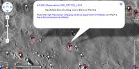
|
|
|
|
|
Aug 21 2012, 03:00 PM
Post
#44
|
|
|
Solar System Cartographer Group: Members Posts: 10229 Joined: 5-April 05 From: Canada Member No.: 227 |
There was a poster on the landing site at LPSC in March. I spoke to Bruce about it at the time.
The site has to be low elevation for EDL and near the equator for good solar power throughout the mission. Matt Golombek and colleagues identified suitable areas in Valles Marineris, the southern Chryse channel areas (well south of Chryse itself), Isidis and Elysium Planitia. Only the last area worked well for their needs, especially latitude. They identified about a dozen ellipses and chose one at the centre of the area as a starting point for the proposal. Now they will do a detailed analysis with HiRISE to pick the best one. One drawback - it's not far from Gale and may have some communication overlap issues (Gale itself was chosen partly to avoid that overlap with Opportunity, as all other MSL sites were near Opportunity's longitude). But that can be dealt with. And about cameras - I think they plan to use off the shelf spares of MER Hazcam and Navcam to save money. So changes are out unless you fancy doing a Kickstarter for them. And the cameras are only needed for characterization and documentation for instrument deployment - nice flat area for the seismometer and a suitable spot for the drill. After that they will collect a full panorama for outreach and site context, but then (after about 60 days) they are shut off to save money - allowing a smaller team to simply monitor the other data rather than construct data collection sequences all the time. Everything is going to be about keeping costs down. Phil -------------------- ... because the Solar System ain't gonna map itself.
Also to be found posting similar content on https://mastodon.social/@PhilStooke Maps for download (free PDF: https://upload.wikimedia.org/wikipedia/comm...Cartography.pdf NOTE: everything created by me which I post on UMSF is considered to be in the public domain (NOT CC, public domain) |
|
|
|
|
Aug 21 2012, 03:11 PM
Post
#45
|
|
|
Member Group: Members Posts: 293 Joined: 29-August 06 From: Columbia, MD Member No.: 1083 |
QUOTE (cIclops @ Aug 21 2012, 06:35 AM) I've seen similar comments swirling around (even by the NASA Administrator), but this is a Discovery mission, NOT part of NASA's separate Mars program. NASA's planetary science division is currently broken down in the following budgetary and organizational lines: Lunar Quest, Mars, Discovery, New Frontiers, Outer Planets, Technology, Research. |
|
|
|
|

|
Lo-Fi Version | Time is now: 26th September 2024 - 08:42 AM |
|
RULES AND GUIDELINES Please read the Forum Rules and Guidelines before posting. IMAGE COPYRIGHT |
OPINIONS AND MODERATION Opinions expressed on UnmannedSpaceflight.com are those of the individual posters and do not necessarily reflect the opinions of UnmannedSpaceflight.com or The Planetary Society. The all-volunteer UnmannedSpaceflight.com moderation team is wholly independent of The Planetary Society. The Planetary Society has no influence over decisions made by the UnmannedSpaceflight.com moderators. |
SUPPORT THE FORUM Unmannedspaceflight.com is funded by the Planetary Society. Please consider supporting our work and many other projects by donating to the Society or becoming a member. |
|