LCROSS en route |

  |
LCROSS en route |
 Sep 29 2009, 01:45 PM Sep 29 2009, 01:45 PM
Post
#31
|
|
|
Solar System Cartographer  Group: Members Posts: 10146 Joined: 5-April 05 From: Canada Member No.: 227 |
http://www.nasa.gov/pdf/386497main_target-selection_web2.pdf
This link goes to a c. 12 MB PDF on target selection. Page 8 has a map showing a more likely location. May not be exact, but pretty close. (see also p. 19) Phil -------------------- ... because the Solar System ain't gonna map itself.
Also to be found posting similar content on https://mastodon.social/@PhilStooke NOTE: everything created by me which I post on UMSF is considered to be in the public domain (NOT CC, public domain) |
 |
 
|
|
Sep 29 2009, 03:06 PM
Post
#32
|
|
|
Member Group: Members Posts: 156 Joined: 22-May 09 From: Ireland Member No.: 4792 |
Thanks Phil
Page 19 is very useful and probably more relevant, (the yellow dots in p8 are more than likely just ID crater centres). As this is a Sept 5 publication and the text is still referring to Cabeus A to be the main target (p23 and elsewhere), the target corrections will undouptedly be refined down the closer to impact date. Whatever one is chosen, however, it's sure to be a good'un  John |
|
|
|
|
Sep 29 2009, 04:34 PM
Post
#33
|
|
 Member Group: Members Posts: 214 Joined: 30-December 05 Member No.: 628 |
Note that in the Colaprete report the Earth observability constraint is actually violated by the Cabeus site that is now the preferred target.
In return for a 50% gain in the Pixon signal (listed as criterion #2), they accepted a 125% increase (0.63 to 1.42) in the solar mask (criterion #1) and almost a ninefold increase (0.33 to 3.07) in the earth observability mask (criterion #3). It's kind of hard to reconcile the ex-ante criteria with the subsequently revealed preference unless the key lies in page 2 "Data not released to the public by individual Projects and Principal Investigators has been removed." To be accurate, that would have to cover the subsequently discovered data too, of course. |
|
|
|
|
Sep 29 2009, 04:55 PM
Post
#34
|
|
|
Solar System Cartographer Group: Members Posts: 10146 Joined: 5-April 05 From: Canada Member No.: 227 |
The latest release did refer to new topographic data showing better illumination than they had anticipated. The Earth observability mask would be very dependent on the exact location chosen, so a small move could alter it significantly.
I really want a map showing the exact location! Also, this is the Centaur target. The second impact site has not been announced yet. It would be nearby, but Colaprete talked about it at LPSC in March 09, responding to a question from me, saying that it might go to a spot with different illumination conditions, like the edge of a permanent shadow area if the Centaur went deep into the shadow area. Phil -------------------- ... because the Solar System ain't gonna map itself.
Also to be found posting similar content on https://mastodon.social/@PhilStooke NOTE: everything created by me which I post on UMSF is considered to be in the public domain (NOT CC, public domain) |
|
|
|
|
Sep 29 2009, 08:19 PM
Post
#35
|
|
 Administrator Group: Admin Posts: 5172 Joined: 4-August 05 From: Pasadena, CA, USA, Earth Member No.: 454 |
Ask and ye shall receive
I asked your questions of Tony Colaprete. He replied that he was hoping to get a map released today, and that the LCROSS ship itself would be targeted somewhat (3 km) away from the Centaur site in order to test a different location.--Emily -------------------- My website - My Patreon - @elakdawalla on Twitter - Please support unmannedspaceflight.com by donating here.
|
|
|
|
|
Oct 2 2009, 03:30 PM
Post
#36
|
||
|
Solar System Cartographer Group: Members Posts: 10146 Joined: 5-April 05 From: Canada Member No.: 227 |
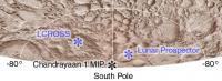
Here's a map of the approximate locations of the three polar impacts - LCROSS (counting as one) and MIP and Lunar Prospector. Only approximate as we still don't have actual coordinates for MIP or the LCROSS target.
I have taken the Cabeus area from LOLA data. It's much better shown here than on the current map on the LCROSS website, which appears to show Cabeus with half its real diameter. That older map is derived from an outdated USGS relief drawing. Phil
-------------------- ... because the Solar System ain't gonna map itself.
Also to be found posting similar content on https://mastodon.social/@PhilStooke NOTE: everything created by me which I post on UMSF is considered to be in the public domain (NOT CC, public domain) |
|
|
|
|
|
|
Oct 2 2009, 04:03 PM
Post
#37
|
|
|
Administrator Group: Admin Posts: 5172 Joined: 4-August 05 From: Pasadena, CA, USA, Earth Member No.: 454 |
What are the coordinates of the different impact sites?
--Emily -------------------- My website - My Patreon - @elakdawalla on Twitter - Please support unmannedspaceflight.com by donating here.
|
|
|
|
|
Oct 2 2009, 04:35 PM
Post
#38
|
|
|
Member Group: Members Posts: 877 Joined: 7-March 05 From: Switzerland Member No.: 186 |
The Google group of LCROSS (amateur) Observation has updated its page too: http://groups.google.com/group/lcross_obse...ion/web/finders
QUOTE Cabeus has selenolographic coordinates of 84.9°S 35.5° W. The target PSR's coordinates have not been official announced but are estimated at approximately 84.4°S 45.0°W
-------------------- |
|
|
|
|
Oct 2 2009, 08:06 PM
Post
#39
|
|
|
Solar System Cartographer Group: Members Posts: 10146 Joined: 5-April 05 From: Canada Member No.: 227 |
From the Observation Group website:
------------------------- Hello Team! Latest update on impact locations: Centaur: -84.70, 310.95E SSC: -84.77, 310.45E These are final and should not change. Nominal timing for impacts: Centaur = 9 Oct 2009 11:31:30 UTC SSC = 9 Oct 2009 11:35:45 UTC There may be some variation from these nominal times through remaining trajectory correction maneuvering. We will post updates to these times as they become available. Any timing updates on impact night will be posted to LCROSS Twitter page, LCROSS Facebook page, and LCROSS-CS. Brian ---------------------- Final LCROSS Centaur and SSC target coordinates (Lat., Lon. in ME) Centaur: -84.675, 311.275 E SSC: -84.729, 310.64 E Elevations (Assumed Lunar radius: 1737.4 km): Centaur target elev: -3.82693 km SSC target elev: -3.80909 km Impact Times: Centaur: 9 Oct 2009 11:31:30 UTC SSC: 9 Oct 2009 11:35:45 UTC Note: These are nominal impact positions and times. Actual impact times based on TCM results may differ (see next slide for uncertainties) ---------------------------- That point is slightly west of the position shown on my map. Phil -------------------- ... because the Solar System ain't gonna map itself.
Also to be found posting similar content on https://mastodon.social/@PhilStooke NOTE: everything created by me which I post on UMSF is considered to be in the public domain (NOT CC, public domain) |
|
|
|
|
Oct 2 2009, 10:41 PM
Post
#40
|
||
|
Member Group: Members Posts: 156 Joined: 22-May 09 From: Ireland Member No.: 4792 |
Took the latter coords., -- rough idea, therefore, but not exact.
John
|
|
|
|
|
|
|
Oct 3 2009, 08:45 PM
Post
#41
|
||
|
Solar System Cartographer Group: Members Posts: 10146 Joined: 5-April 05 From: Canada Member No.: 227 |
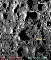
Here's the latest info from Tony Colaprete, via the LCROSS Observation Group:
http://lcross.arc.nasa.gov/docs/LCROSS_Tar...date_100209.ppt LCROSS Observation Group: http://groups.google.com/group/lcross_observation And a modified version of his map:
"Centaur Impact indicated by Red circle, SSC impact indicated by Blue circle" The shading is LOLA elevation, not hydrogen abundance. Phil -------------------- ... because the Solar System ain't gonna map itself.
Also to be found posting similar content on https://mastodon.social/@PhilStooke NOTE: everything created by me which I post on UMSF is considered to be in the public domain (NOT CC, public domain) |
|
|
|
|
|
|
Oct 4 2009, 12:53 AM
Post
#42
|
|
|
Member Group: Members Posts: 340 Joined: 11-April 08 From: Sydney, Australia Member No.: 4093 |
QUOTE (Phil Stooke @ Oct 3 2009, 06:06 AM)  Nominal timing for impacts: Centaur = 9 Oct 2009 11:31:30 UTC SSC = 9 Oct 2009 11:35:45 UTC Thanks Phil, this is very useful. Updated my realtime simulations with that info. Having troubles finding anything of a timeline of upcoming events, or the very latest trajectory info for that matter - the data on the Horizons system has LCROSS going through the moon  and I could not find any SPICE kernels. Unfortunately I'll be on the road for most of next week and can only "tweak" my existing trajectory data to match predicted impact times, can't process SPICE kernels on the road. and I could not find any SPICE kernels. Unfortunately I'll be on the road for most of next week and can only "tweak" my existing trajectory data to match predicted impact times, can't process SPICE kernels on the road.
-------------------- |
|
|
|
|
Oct 4 2009, 02:01 PM
Post
#43
|
|
|
Member Group: Members Posts: 156 Joined: 22-May 09 From: Ireland Member No.: 4792 |
That's better!
The recent DIVINER image is proving quite useful to 'see' the area they're aiming at... LINK ...looks like it's in a shallow spot of two small merged impact craters. John |
|
|
|
|
Oct 4 2009, 02:36 PM
Post
#44
|
||
|
Solar System Cartographer Group: Members Posts: 10146 Joined: 5-April 05 From: Canada Member No.: 227 |
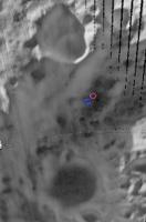
This is what I get by overlaying Colaprete's map over Diviner to check the position.
Phil
-------------------- ... because the Solar System ain't gonna map itself.
Also to be found posting similar content on https://mastodon.social/@PhilStooke NOTE: everything created by me which I post on UMSF is considered to be in the public domain (NOT CC, public domain) |
|
|
|
|
|
|
Oct 4 2009, 03:45 PM
Post
#45
|
|
|
Member Group: Members Posts: 156 Joined: 22-May 09 From: Ireland Member No.: 4792 |
Isn't that exact same as in my link above? John I don't know - but you inline quoted everything from the previous quote. Stop it. Final warning. Further posts will just be deleted - ADMIN |
|
|
|
|

|
Lo-Fi Version | Time is now: 19th April 2024 - 10:49 PM |
|
RULES AND GUIDELINES Please read the Forum Rules and Guidelines before posting. IMAGE COPYRIGHT |
OPINIONS AND MODERATION Opinions expressed on UnmannedSpaceflight.com are those of the individual posters and do not necessarily reflect the opinions of UnmannedSpaceflight.com or The Planetary Society. The all-volunteer UnmannedSpaceflight.com moderation team is wholly independent of The Planetary Society. The Planetary Society has no influence over decisions made by the UnmannedSpaceflight.com moderators. |
SUPPORT THE FORUM Unmannedspaceflight.com is funded by the Planetary Society. Please consider supporting our work and many other projects by donating to the Society or becoming a member. |
|