Finishing work in and around Seitah, sols 238-378 |

  |
Finishing work in and around Seitah, sols 238-378 |
 Oct 21 2021, 06:50 AM Oct 21 2021, 06:50 AM
Post
#1
|
|
|
Solar System Cartographer  Group: Members Posts: 10229 Joined: 5-April 05 From: Canada Member No.: 227 |
It's time to start a new thread - this will cover the remaining work in Seitah and the drive back to the landing site.
Phil -------------------- ... because the Solar System ain't gonna map itself.
Also to be found posting similar content on https://mastodon.social/@PhilStooke Maps for download (free PDF: https://upload.wikimedia.org/wikipedia/comm...Cartography.pdf NOTE: everything created by me which I post on UMSF is considered to be in the public domain (NOT CC, public domain) |
 |
 
|
|
Oct 22 2021, 12:13 AM
Post
#2
|
||
|
Solar System Cartographer Group: Members Posts: 10229 Joined: 5-April 05 From: Canada Member No.: 227 |
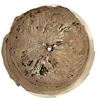
OK, a drive up to the outcrop on sol 238. Here is a circular view of the new location.
Phil
-------------------- ... because the Solar System ain't gonna map itself.
Also to be found posting similar content on https://mastodon.social/@PhilStooke Maps for download (free PDF: https://upload.wikimedia.org/wikipedia/comm...Cartography.pdf NOTE: everything created by me which I post on UMSF is considered to be in the public domain (NOT CC, public domain) |
|
|
|
|
|
|
Oct 22 2021, 12:13 PM
Post
#3
|
||
 Member Group: Members Posts: 790 Joined: 9-May 21 From: Germany Member No.: 9017 |
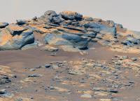
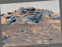
An outcrop of compact, layered rock with overlying vesicular rock fragments on sol 238.
Mastcam-Z left eye filter 0 (RGB), colors enhanced.
|
|
|
|
|
|
|
Oct 22 2021, 04:19 PM
Post
#4
|
|
|
Senior Member Group: Members Posts: 3009 Joined: 30-October 04 Member No.: 105 |
Tau, this stratigraphy is getting interesting.
Time to backtrack and try to intuit the bedding orientation. --Bill -------------------- |
|
|
|
|
Oct 22 2021, 10:16 PM
Post
#5
|
|
|
Senior Member Group: Members Posts: 1057 Joined: 17-February 09 Member No.: 4605 |
Perseverance had a pretty fair tilt when this was taken and these are probably as horizontal as the precious ridge.
|
|
|
|
|
Oct 23 2021, 12:46 AM
Post
#6
|
||
|
Solar System Cartographer Group: Members Posts: 10229 Joined: 5-April 05 From: Canada Member No.: 227 |
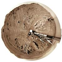
Sol 239, another drive... another circular panorama.
Phil
-------------------- ... because the Solar System ain't gonna map itself.
Also to be found posting similar content on https://mastodon.social/@PhilStooke Maps for download (free PDF: https://upload.wikimedia.org/wikipedia/comm...Cartography.pdf NOTE: everything created by me which I post on UMSF is considered to be in the public domain (NOT CC, public domain) |
|
|
|
|
|
|
Oct 23 2021, 01:20 AM
Post
#7
|
|
|
Senior Member Group: Members Posts: 1057 Joined: 17-February 09 Member No.: 4605 |
QUOTE (tau @ Oct 22 2021, 12:13 PM)  An outcrop of compact, layered rock with overlying vesicular rock fragments on sol 238. To me this looks more like honeycomb weathering of basaltic sandstone rather than vesicular basalt tau, but I stand to be corrected. |
|
|
|
|
Oct 23 2021, 12:45 PM
Post
#8
|
|
|
Member Group: Members Posts: 790 Joined: 9-May 21 From: Germany Member No.: 9017 |
If the term "vesicular" implies a specific type of rock or origin of the rock, then I would rather refer to it as "spongeous appearance".
I would not rule out weathering as the reason of the small holes/cavities. |
|
|
|
|
Oct 23 2021, 07:18 PM
Post
#9
|
||||
|
Member Group: Members Posts: 790 Joined: 9-May 21 From: Germany Member No.: 9017 |
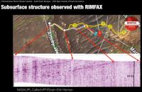
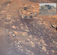
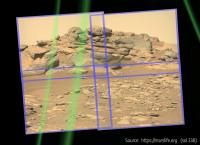
QUOTE (Bill Harris @ Oct 22 2021, 06:19 PM) Tau, this stratigraphy is getting interesting. Time to backtrack and try to intuit the bedding orientation. QUOTE (serpens @ Oct 23 2021, 12:16 AM) Perseverance had a pretty fair tilt when this was taken and these are probably as horizontal as the precious ridge. As to the bedding orientation, here is a sol 236 Navcam image with the sol 238 Mastcam-Z image as inset. If there is any tilt of the rover, it seems to be rather small. Navcam and Mastcam-Z are looking east-northeast. The layers are dipping to the right, i.e., towards the Artuby ridge. This is consistent with the Rimfax results in the screenshot below, which is from a presentation by Kathryn Stack Morgan. Thanks to cIclops for the link to this very interesting video! The part about Rimfax and Séítah layering begins after 21 minutes. Here is a direct link to this part. The field of view of the sol 238 Mastcam-Z image and the position of Perseverance on sol 239 are marked in the upper right section of a helicopter photo from sol 174.
EDIT: Corrected the compass direction that the Navcam and Mastcam-Z looked at. I had accidentaly typed west where I meant east. The correct direction is east-nordeast. |
|||
|
|
|
|||
|
Oct 23 2021, 07:31 PM
Post
#10
|
|
|
Senior Member Group: Members Posts: 3009 Joined: 30-October 04 Member No.: 105 |
I haven't had the chance to look at that video presentation yet.
The RIMFAX data fairly well corresponds to my general observations. In a general sense, the "beds are essentially flat-lying with a gentle regional dip to the southwest". Artuby ridge is stratigraphically the high point of this section of the traverse and we are headed along stratigraphically lower units. And Artuby is the youngest unit, and we are traversing along increasingly older units. Nice presentation of yours. --Bill -------------------- |
|
|
|
|
Oct 23 2021, 10:49 PM
Post
#11
|
||
|
Senior Member Group: Members Posts: 1057 Joined: 17-February 09 Member No.: 4605 |
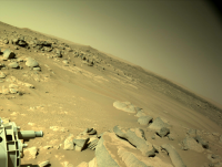
Indeed, good one tau. The Rimfax trace doesn't show any real change in the angle of dip despite a 90 degree turn across the terrain, not that I have any skill whatsoever in interpreting such.
The reason I suspected an element of tilt was due to this Sol 238 Navcam image.
Attached thumbnail(s)
|
|
|
|
|
|
|
Oct 24 2021, 12:07 AM
Post
#12
|
|
|
Solar System Cartographer Group: Members Posts: 10229 Joined: 5-April 05 From: Canada Member No.: 227 |
That picture was taken at the sol 238 location, but Tau's image was from the sol 237 location, before the drive on sol 238.
Phil -------------------- ... because the Solar System ain't gonna map itself.
Also to be found posting similar content on https://mastodon.social/@PhilStooke Maps for download (free PDF: https://upload.wikimedia.org/wikipedia/comm...Cartography.pdf NOTE: everything created by me which I post on UMSF is considered to be in the public domain (NOT CC, public domain) |
|
|
|
|
Oct 24 2021, 10:45 AM
Post
#13
|
||
 Senior Member Group: Members Posts: 2431 Joined: 30-January 13 From: Penang, Malaysia. Member No.: 6853 |
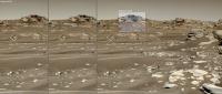
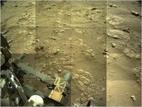
4x4 Navcam tile of Perseverance's post-drive workspace on sol 239.
Very roughly assembled and reduced to fit upload limits
|
|
|
|
|
|
|
Oct 24 2021, 04:41 PM
Post
#14
|
|||
|
Member Group: Members Posts: 790 Joined: 9-May 21 From: Germany Member No.: 9017 |
QUOTE (serpens @ Oct 23 2021, 12:16 AM) Perseverance had a pretty fair tilt when this was taken and these are probably as horizontal as the precious ridge. The tilt of the previously shown sol 238 Mastcam-Z picture can be estimated with the projection of the images onto a sphere provided online by marslife.org. The mast was tilted about 4° to the left (that's more than I presumed from the Navcam photos). When we apply the tilt to the picture, the layers are still tilted to the right (towards Artuby ridge) with an angle of about 7° to 8°. This is in accordance with the Rimfax results where we have a dip angle of about 12° towards Artuby ridge.
|
||
|
|
|
||
|
Oct 24 2021, 09:15 PM
Post
#15
|
|
|
Senior Member Group: Members Posts: 3009 Joined: 30-October 04 Member No.: 105 |
This site you noted, https://marslife.org/ , looks interesting and potentially useful. Let me dig around and find documentation on the site.
--Bill -------------------- |
|
|
|
|

|
Lo-Fi Version | Time is now: 26th September 2024 - 06:46 PM |
|
RULES AND GUIDELINES Please read the Forum Rules and Guidelines before posting. IMAGE COPYRIGHT |
OPINIONS AND MODERATION Opinions expressed on UnmannedSpaceflight.com are those of the individual posters and do not necessarily reflect the opinions of UnmannedSpaceflight.com or The Planetary Society. The all-volunteer UnmannedSpaceflight.com moderation team is wholly independent of The Planetary Society. The Planetary Society has no influence over decisions made by the UnmannedSpaceflight.com moderators. |
SUPPORT THE FORUM Unmannedspaceflight.com is funded by the Planetary Society. Please consider supporting our work and many other projects by donating to the Society or becoming a member. |
|