Finishing work in and around Seitah, sols 238-378 |

  |
Finishing work in and around Seitah, sols 238-378 |
 Oct 25 2021, 12:08 AM Oct 25 2021, 12:08 AM
Post
#16
|
|
|
Senior Member  Group: Members Posts: 1057 Joined: 17-February 09 Member No.: 4605 |
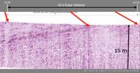
The dipping structure in the Rimfax trace seems to disappear at the third position Tau and it would be interesting to see subsequent results to determine if similar structure re-appears. The trace presentation seems to be truncated in the X axis which accentuates the angle of dip which if the trace were extended to agree with the 15 metre depth would be around 7 degrees.
|
 |
 
|
|
Oct 25 2021, 05:19 PM
Post
#17
|
|||
 Member Group: Members Posts: 790 Joined: 9-May 21 From: Germany Member No.: 9017 |
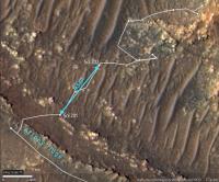
The Rimfax diagram has two small marks for sol 201 and sol 202.
In the Hirise map, the positions of sol 201 and sol 202 can be connected by a stright line ("as the crow flies") with a linear distance of about 43 m. This line is almost perpendicular to Artuby ridge. The ridge can be assumed to represent a strike line of the layers. When the Rimfax diagram between sol 201 and sol 202 is stretched horizontally according to the vertical scale, we get a dip angle of about 11° to 12°.
|
||
|
|
|
||
|
Oct 26 2021, 04:12 PM
Post
#18
|
||||
|
Member Group: Members Posts: 790 Joined: 9-May 21 From: Germany Member No.: 9017 |
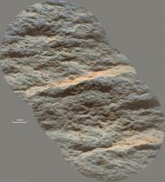
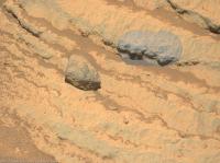
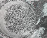
Sol 242 SuperCam Remote Micro Imager with double context.
Grain-size measurement by stereoscopy gives an average grain diameter of about 1.3 mm
|
|||
|
|
|
|||
|
Nov 1 2021, 12:02 AM
Post
#19
|
||
 Senior Member Group: Members Posts: 2431 Joined: 30-January 13 From: Penang, Malaysia. Member No.: 6853 |
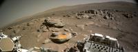
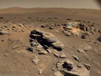
Roughly processed sol 248 end-of-drive 4 tile Navcam. The site index incremented which could indicate we are at, or very close to the next sample site.
|
|
|
|
|
|
|
Nov 1 2021, 03:15 AM
Post
#20
|
|
|
Solar System Cartographer Group: Members Posts: 10229 Joined: 5-April 05 From: Canada Member No.: 227 |
Yes, a move, but really just a turn in place (possibly involving a drive downslope, a turn and back upslope, but I only see the end result).
Phil -------------------- ... because the Solar System ain't gonna map itself.
Also to be found posting similar content on https://mastodon.social/@PhilStooke Maps for download (free PDF: https://upload.wikimedia.org/wikipedia/comm...Cartography.pdf NOTE: everything created by me which I post on UMSF is considered to be in the public domain (NOT CC, public domain) |
|
|
|
|
Nov 1 2021, 08:54 AM
Post
#21
|
|
|
Senior Member Group: Members Posts: 3009 Joined: 30-October 04 Member No.: 105 |
QUOTE (PaulH51 @ Oct 31 2021, 07:02 PM)  Roughly processed sol 248 end-of-drive 4 tile Navcam. The site index incremented which could indicate we are at, or very close to the next sample site. Plenty of interesting contacts here. Especially that (apparently) loose rock at the top with the dark basaltic (?) unit on top of the grey clastic (?) unit on top of the in-place units. --Bill -------------------- |
|
|
|
|
Nov 1 2021, 01:05 PM
Post
#22
|
||
|
Member Group: Members Posts: 790 Joined: 9-May 21 From: Germany Member No.: 9017 |
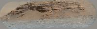
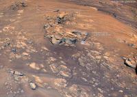
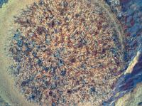
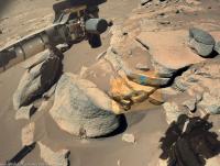
Kodiak behind Séítah as seen by the SuperCam Remote Micro-Imager on Sol 248
|
|
|
|
|
|
|
Nov 1 2021, 04:33 PM
Post
#23
|
||
|
Solar System Cartographer Group: Members Posts: 10229 Joined: 5-April 05 From: Canada Member No.: 227 |
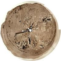
That's a beautiful image of Kodiak. Thanks!
Here is a circular panorama for the current position. Phil
-------------------- ... because the Solar System ain't gonna map itself.
Also to be found posting similar content on https://mastodon.social/@PhilStooke Maps for download (free PDF: https://upload.wikimedia.org/wikipedia/comm...Cartography.pdf NOTE: everything created by me which I post on UMSF is considered to be in the public domain (NOT CC, public domain) |
|
|
|
|
|
|
Nov 1 2021, 05:35 PM
Post
#24
|
|
|
Solar System Cartographer Group: Members Posts: 10229 Joined: 5-April 05 From: Canada Member No.: 227 |
Paul: "The site index incremented which could indicate we are at, or very close to the next sample site."
I was asked about site numbering, and i don't have specific information about Persererance, but this is a document for Curiosity which discusses sites.  MSL_Coordinate_Frames_Mar5_2013.pdf ( 343.63K )
Number of downloads: 422
MSL_Coordinate_Frames_Mar5_2013.pdf ( 343.63K )
Number of downloads: 422I expect the situation is the same for Perseverance. A new site number doesn't really suggest sampling is about to happen, though I expect it is. Phil -------------------- ... because the Solar System ain't gonna map itself.
Also to be found posting similar content on https://mastodon.social/@PhilStooke Maps for download (free PDF: https://upload.wikimedia.org/wikipedia/comm...Cartography.pdf NOTE: everything created by me which I post on UMSF is considered to be in the public domain (NOT CC, public domain) |
|
|
|
|
Nov 1 2021, 06:38 PM
Post
#25
|
|
|
Founder Group: Chairman Posts: 14434 Joined: 8-February 04 Member No.: 1 |
The site incrementing is usually because the propagated error in attitude knowledge has reached a certain limit. It's usually based on cumulative IMU on time.
|
|
|
|
|
Nov 1 2021, 08:43 PM
Post
#26
|
||||
|
Member Group: Members Posts: 790 Joined: 9-May 21 From: Germany Member No.: 9017 |
Sol 247 SuperCam RMI with Mastcam-Z context and sol 147 Helicopter color camera context
|
|||
|
|
|
|||
|
Nov 5 2021, 05:01 PM
Post
#27
|
||||
|
Member Group: Members Posts: 790 Joined: 9-May 21 From: Germany Member No.: 9017 |
Sol 252 SuperCam RMI with Mastcam-Z and Navcam context
|
|||
|
|
|
|||
|
Nov 6 2021, 08:09 AM
Post
#28
|
|
|
Senior Member Group: Members Posts: 2431 Joined: 30-January 13 From: Penang, Malaysia. Member No.: 6853 |
|
|
|
|
|
Nov 6 2021, 01:27 PM
Post
#29
|
|||
|
Member Group: Members Posts: 790 Joined: 9-May 21 From: Germany Member No.: 9017 |
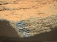
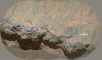
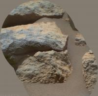
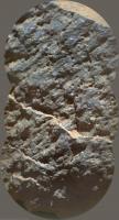
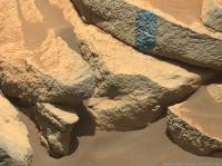
A sol 253 Sherloc Watson camera image with enhanced colors and an anaglyph of the abrasion target.
Could that small white triangle above the center of the abraded area be a lost part of the abrasion tool?
|
||
|
|
|
||
|
Nov 6 2021, 06:05 PM
Post
#30
|
||||
|
Member Group: Members Posts: 790 Joined: 9-May 21 From: Germany Member No.: 9017 |
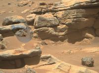
Sol 253 SuperCam RMI with Mastcam-Z and Navcam context
|
|||
|
|
|
|||
|

|
Lo-Fi Version | Time is now: 26th September 2024 - 07:52 PM |
|
RULES AND GUIDELINES Please read the Forum Rules and Guidelines before posting. IMAGE COPYRIGHT |
OPINIONS AND MODERATION Opinions expressed on UnmannedSpaceflight.com are those of the individual posters and do not necessarily reflect the opinions of UnmannedSpaceflight.com or The Planetary Society. The all-volunteer UnmannedSpaceflight.com moderation team is wholly independent of The Planetary Society. The Planetary Society has no influence over decisions made by the UnmannedSpaceflight.com moderators. |
SUPPORT THE FORUM Unmannedspaceflight.com is funded by the Planetary Society. Please consider supporting our work and many other projects by donating to the Society or becoming a member. |
|