InSight Surface Operations, 26 Nov 2018- 21 Dec 2022 |

  |
InSight Surface Operations, 26 Nov 2018- 21 Dec 2022 |
 Dec 7 2018, 02:37 AM Dec 7 2018, 02:37 AM
Post
#211
|
||
|
Solar System Cartographer  Group: Members Posts: 10159 Joined: 5-April 05 From: Canada Member No.: 227 |
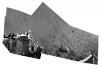
My previous mosaic can be fitted with the foreground of the ICC image (using the latest low-sun version). As much as possible of that area will be replaced with IDC images as they become available. Again - distorions abound but will be corrected later.
Phil
-------------------- ... because the Solar System ain't gonna map itself.
Also to be found posting similar content on https://mastodon.social/@PhilStooke Maps for download (free PD: https://upload.wikimedia.org/wikipedia/comm...Cartography.pdf NOTE: everything created by me which I post on UMSF is considered to be in the public domain (NOT CC, public domain) |
|
 |
 
|
|
|
Dec 7 2018, 03:22 AM
Post
#212
|
|
|
Forum Contributor Group: Members Posts: 1372 Joined: 8-February 04 From: North East Florida, USA. Member No.: 11 |
"The mission's primary mission is scheduled for two Earth years, or one Mars year plenty of time to gather data from the Red Planet's surface."
er, subsurface...  https://mars.nasa.gov/news/8396/nasas-mars-...m/?site=insight |
|
|
|
|
Dec 7 2018, 03:52 AM
Post
#213
|
|
|
Forum Contributor Group: Members Posts: 1372 Joined: 8-February 04 From: North East Florida, USA. Member No.: 11 |
|
|
|
|
|
Dec 7 2018, 07:59 AM
Post
#214
|
||
|
Solar System Cartographer Group: Members Posts: 10159 Joined: 5-April 05 From: Canada Member No.: 227 |
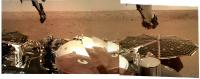
Using these images is going to be tricky - but not beyond our panorama experts, I'm sure. This is a preliminary attempt to work with what we have, and using bits of one image to mask out parts of the arm in another image. Very rough but I'm sure we will see better soon.
Phil
-------------------- ... because the Solar System ain't gonna map itself.
Also to be found posting similar content on https://mastodon.social/@PhilStooke Maps for download (free PD: https://upload.wikimedia.org/wikipedia/comm...Cartography.pdf NOTE: everything created by me which I post on UMSF is considered to be in the public domain (NOT CC, public domain) |
|
|
|
|
|
|
Dec 7 2018, 08:09 AM
Post
#215
|
|
 Senior Member Group: Members Posts: 2428 Joined: 30-January 13 From: Penang, Malaysia. Member No.: 6853 |
QUOTE (Phil Stooke @ Dec 7 2018, 03:59 PM)  Very rough but I'm sure we will see better soon. Looking good, better than my effort Phil 
|
|
|
|
|
Dec 7 2018, 10:03 AM
Post
#216
|
||
|
Member Group: Members Posts: 102 Joined: 29-January 10 From: Poland Member No.: 5205 |
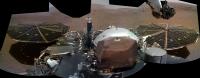
Here is my version of InSight panorama
-------------------- Adam Hurcewicz from Poland
|
|
|
|
|
|
|
Dec 7 2018, 10:08 AM
Post
#217
|
|
 Member Group: Members Posts: 550 Joined: 1-May 06 From: Scotland (Ecosse, Escocia) Member No.: 759 |
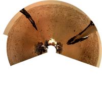
A lovely panorama, Phil, and gives us the first wider view of the location.
If we are indeed in one of the sand-filled crater hollows, as has been speculated, it looks like we are on the edge of it. |
|
|
|
|
Dec 7 2018, 12:12 PM
Post
#218
|
|
 Senior Member Group: Moderator Posts: 2262 Joined: 9-February 04 From: Melbourne - Oz Member No.: 16 |
-------------------- |
|
|
|
|
Dec 7 2018, 05:59 PM
Post
#219
|
||
|
Solar System Cartographer Group: Members Posts: 10159 Joined: 5-April 05 From: Canada Member No.: 227 |
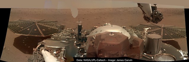
Excellent work from everyone! I added the last image and made a circular version. North roughly at the top, as for all my circular projections.
Phil
-------------------- ... because the Solar System ain't gonna map itself.
Also to be found posting similar content on https://mastodon.social/@PhilStooke Maps for download (free PD: https://upload.wikimedia.org/wikipedia/comm...Cartography.pdf NOTE: everything created by me which I post on UMSF is considered to be in the public domain (NOT CC, public domain) |
|
|
|
|
|
|
Dec 7 2018, 08:33 PM
Post
#220
|
|||
|
Member Group: Members Posts: 866 Joined: 15-March 05 From: Santa Cruz, CA Member No.: 196 |
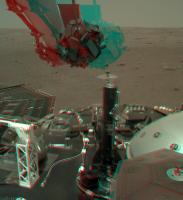
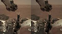
great image looking down at the lander pad plus another set of images 84 & 89 suitable for stereo. There seem to be some noticeable differences on a specific region of the solar array (rigth next to the glint, which seems larger in one image due to gain), it looks perhaps due to a patch of dust getting blown around, though i see nothing comparable on the deck, maybe just specular differences due to perspective, or perhaps even re-reflections of light reflected off the arm itself?
|
||
|
|
|
||
|
Dec 7 2018, 09:18 PM
Post
#221
|
|
 Senior Member Group: Members Posts: 1428 Joined: 26-July 08 Member No.: 4270 |
The position of the arm (and consequently the camera) has moved between the two images. Whatever the solar panels are reflecting (the sky I guess), we're seeing it at a different angle. If we assume the solar panels aren't a perfectly flat reflective surface, that seems to me a sufficient explanation. Sort of like looking at the reflection of a kitchen light in a crumpled plastic bag.
-------------------- -- Hungry4info (Sirius_Alpha)
|
|
|
|
|
Dec 7 2018, 09:53 PM
Post
#222
|
|
|
Senior Member Group: Members Posts: 2920 Joined: 14-February 06 From: Very close to the Pyrénées Mountains (France) Member No.: 682 |
Mars « wind »: https://spacegate.cnes.fr/fr/insight-histor...u-vent-sur-mars
-------------------- |
|
|
|
|
Dec 8 2018, 12:17 AM
Post
#223
|
|
 Administrator Group: Admin Posts: 5172 Joined: 4-August 05 From: Pasadena, CA, USA, Earth Member No.: 454 |
I started a new thread for discussion of landing site localization and various views people here will likely be generating of the landing site.
Phil, I moved your post there. Once we get a good view of the workspace and you start mapping out activities, you might create a workspace thread that's akin to a route map thread. -------------------- My website - My Patreon - @elakdawalla on Twitter - Please support unmannedspaceflight.com by donating here.
|
|
|
|
|
Dec 8 2018, 12:34 AM
Post
#224
|
||
 Member Group: Members Posts: 684 Joined: 24-July 15 Member No.: 7619 |
QUOTE (Phil Stooke @ Dec 7 2018, 06:59 PM) Excellent work from everyone! I added the last image and made a circular version. North roughly at the top, as for all my circular projections. Phil
Is there a particular spherical viewer and settings you use with this format? Or is this an "eyes are used to this" thing, like reflexively seeing 3d from cross-eyed stereo? |
|
|
|
|
|
|
Dec 8 2018, 05:46 AM
Post
#225
|
|
|
Junior Member Group: Members Posts: 48 Joined: 8-August 12 Member No.: 6507 |
QUOTE (jamescanvin @ Dec 7 2018, 05:12 AM) Wonderful panorama from just a few photos. Saw a few images today (not sure why there seems to be a periodic delay on the raw image website, so days it is right in time with the download, some days it is delayed) that show the 3rd footpad and my cruise thrusters. The thruster closeout bracket (that was exposed to the entry flow and heating) is very discolored. Being a Titanium plate this took some high heating rates and the partial blue color must mean there was some free O in the upper atmosphere. If this does in fact present startling science (i doubt it since there should be free O in the upper atmosphere) then I respectfully rescind this conclusion I made since I am not at all a planetary scientist (just a humble engineer). P.S. back before entry I had asked folks if they had any good idea for an EDL song. I received lots of great responses, but luckily that morning driving into work KBCO in Boulder played Under Pressure by David Bowie and Queen. Being one of may favorite songs I quickly decided that is the EDL song for InSight. Most of the team at work agreed (we were under pressure that day and once it hit the atmosphere InSight itself was under atmospheric pressure). Heard the song again today and it brought me right back to that day. |
|
|
|
|

|
Lo-Fi Version | Time is now: 9th May 2024 - 12:53 PM |
|
RULES AND GUIDELINES Please read the Forum Rules and Guidelines before posting. IMAGE COPYRIGHT |
OPINIONS AND MODERATION Opinions expressed on UnmannedSpaceflight.com are those of the individual posters and do not necessarily reflect the opinions of UnmannedSpaceflight.com or The Planetary Society. The all-volunteer UnmannedSpaceflight.com moderation team is wholly independent of The Planetary Society. The Planetary Society has no influence over decisions made by the UnmannedSpaceflight.com moderators. |
SUPPORT THE FORUM Unmannedspaceflight.com is funded by the Planetary Society. Please consider supporting our work and many other projects by donating to the Society or becoming a member. |
|