MSL "Drive, drive, drive" toward Glenelg, The scientists (mostly) get the keys - sols 38-56 |

  |
MSL "Drive, drive, drive" toward Glenelg, The scientists (mostly) get the keys - sols 38-56 |
 Sep 13 2012, 09:33 PM Sep 13 2012, 09:33 PM
Post
#1
|
|
 Administrator  Group: Admin Posts: 5172 Joined: 4-August 05 From: Pasadena, CA, USA, Earth Member No.: 454 |
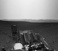
Matt Heverly tweeted earlier today that they're "on the road again," planning the seventh drive. So sol 39 will be a driving day, and it's time to start a new thread! In yesterday's press briefing, Joy Crisp said the plan was to "drive, drive, drive," though they will probably stop again before getting to Glenelg if they spot a good rock to use for the testing of drilling and sample acquisition and delivery.
As usual, keep conversation of the events and images of sols 30 through 37 in the appropriate thread. -------------------- My website - My Patreon - @elakdawalla on Twitter - Please support unmannedspaceflight.com by donating here.
|
 |
 
|
|
Sep 13 2012, 10:03 PM
Post
#2
|
|
|
Senior Member Group: Members Posts: 3516 Joined: 4-November 05 From: North Wales Member No.: 542 |
Can I just ask - why do we need such frequent thread changes? That last one was only 9 days. Not everybody keeps track of exactly when the image they want to comment on was acquired. I'm not surprised posts have been appearing in the wrong threads as fredk reports. For some who have interesting things to share this could be a barrier to contributing at all.
|
|
|
|
|
Sep 13 2012, 10:11 PM
Post
#3
|
|
 The Poet Dude Group: Moderator Posts: 5551 Joined: 15-March 04 From: Kendal, Cumbria, UK Member No.: 60 |
It makes sense for two reasons.
1) MSL's operations so far have been split into very definite stages, so posting about events which occur during those periods in exclusive threads is a lot tidier than having one or two very long threads, with posts referring to events past, present and future. That's just very messy. 2) In the future, when MSL is working her way up Mt Sharp, and we want to look back on the rocks she saw, and the vistas she stared out and up at before she headed for The Promised Land, for comparison, it will be much easier to locate that information. -------------------- |
|
|
|
|
Sep 13 2012, 10:34 PM
Post
#4
|
|
|
Senior Member Group: Members Posts: 3516 Joined: 4-November 05 From: North Wales Member No.: 542 |
I agree that makes sense over the longer term. When we're up the hill we'll need to refer back to when we were down on the plain, and that should be in a separate place. But by then, who will remember the many different phases of the engineering checkout? I think one pre-Glenelg thread would have been enough, and more in keeping with the pace adopted for Opportunity, which has proved highly successful.
Anyhow, that's my last post on the subject. I love this place and don't want to rock the boat. |
|
|
|
|
Sep 13 2012, 10:52 PM
Post
#5
|
|
 Member Group: Members Posts: 754 Joined: 9-February 07 Member No.: 1700 |
We mustn't ~needle~ the Admins about their threads.
 *backs away, carefully* *backs away, carefully*
|
|
|
|
|
Sep 13 2012, 10:58 PM
Post
#6
|
|
|
Administrator Group: Admin Posts: 5172 Joined: 4-August 05 From: Pasadena, CA, USA, Earth Member No.: 454 |
I know I'm not alone among journalists (or scientists) who try to use UMSF as a historical archive of mission events, and for really nice-quality processed versions of raw images. In the beginning of the MER missions we weren't so careful, and those threads are incredibly difficult to hunt through for images. Over time the MER threads developed their method of beginning new threads with drives, which has really helped in sorting the history.
Keeping track of which sol the image was captured on is not only easy (it's listed in the filename of the Malin cameras, and is easy to firgure out using Ludo's or Joe's raw image browsers) but it's also important, because there is a context and a reason for taking photos that you can really only keep track of by following the mission chronology. The first part of the mission will get chopped up into smaller pieces because there is so much interest and so many people trying new things with the images, and also because Curiosity's drives are short. Once we've gotten used to the mission and to the types of images it returns and we understand what we're seeing in the images and have begun to rely on certain people for producing certain kinds of image products, the post rate will drop and the amount of time covered in one thread will lengthen. Still, we'll generally try to keep it down to a few hundred posts per thread. This thread may last longer than previous ones, because hopefully we're really looking at the beginning of the science mission here. I'm guessing it'll last until we arrive at Glenelg, and we'll break it and start a new thread there. Curiosity's mission, like Opportunity's, will probably separate fairly neatly into interleaved drives and science sites; these threads will reflect that. -------------------- My website - My Patreon - @elakdawalla on Twitter - Please support unmannedspaceflight.com by donating here.
|
|
|
|
|
Sep 13 2012, 11:06 PM
Post
#7
|
|
 Senior Member Group: Members Posts: 4247 Joined: 17-January 05 Member No.: 152 |
I think the "sols x through y" subtitles are going to be really useful down the road. Another idea would be to demark the various mission phases on a route map, to help people find the corresponding thread.
|
|
|
|
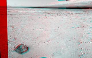
|
Sep 14 2012, 01:01 AM
Post
#8
|
|
|
Forum Contributor Group: Members Posts: 1372 Joined: 8-February 04 From: North East Florida, USA. Member No.: 11 |
When Curiosity is driving in-between 100 m high mesa's and butts I think the plains will be quite forgotten
 . . |
|
|
|
|
Sep 14 2012, 02:02 AM
Post
#9
|
|
 Member Group: Members Posts: 444 Joined: 1-July 05 From: New York City Member No.: 424 |
|
|
|
|
|
Sep 14 2012, 04:20 AM
Post
#10
|
|
|
Member Group: Members Posts: 444 Joined: 1-July 05 From: New York City Member No.: 424 |
Not much that would have been new to umsf members.
Richard Cook estimated that ChemCam has made several hundred observations already (my question, submitted via chat). Edit: Cook also said that when the drivers are able to employ the full range of Curiosity's navigation software capabilities (I think he mentioned visual odometery as one, although I didn't think that the VisDom mode is known for speed), Curiosity would be able to drive about 100-200 meters on a good day. The suggestion that 200 meter days might become routine on appropriate terrain (he didn't use those words, but that's my sense of what he was saying) is more aggressive than comments that I recall from past press conferences. But of course, we'll get there when we get there ... This post has been edited by Tom Tamlyn: Sep 14 2012, 04:55 AM |
|
|
|
|
Sep 14 2012, 05:35 AM
Post
#11
|
|
|
Member Group: Members Posts: 470 Joined: 24-March 04 From: Finland Member No.: 63 |
200 metres per sol is the original engineering goal for MSL, that has been mentioned in various sources. Of course it depends on the navigation needed because of the terrain, but I'd expect it would be achievable in this terrain before the dunes and the mountain. I have been a bit surprised by the last few short drives - I thought there would be more of an increase after the first couple of drivers. Though I guess the last drive was targeted, since they needed a specific spot for the arm calibrations.
-------------------- Antti Kuosmanen
|
|
|
|
|
Sep 14 2012, 08:13 AM
Post
#12
|
||
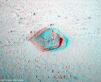
 Senior Member Group: Moderator Posts: 3431 Joined: 11-August 04 From: USA Member No.: 98 |
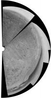
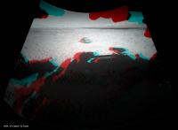
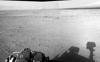
Sol 38 drive images are down. Here's a quick Navcam anaglyph looking forward and right a bit.
Attached thumbnail(s)
|
|
|
|
|
|
|
Sep 14 2012, 09:03 AM
Post
#13
|
||
|
Senior Member Group: Moderator Posts: 4279 Joined: 19-April 05 From: .br at .es Member No.: 253 |
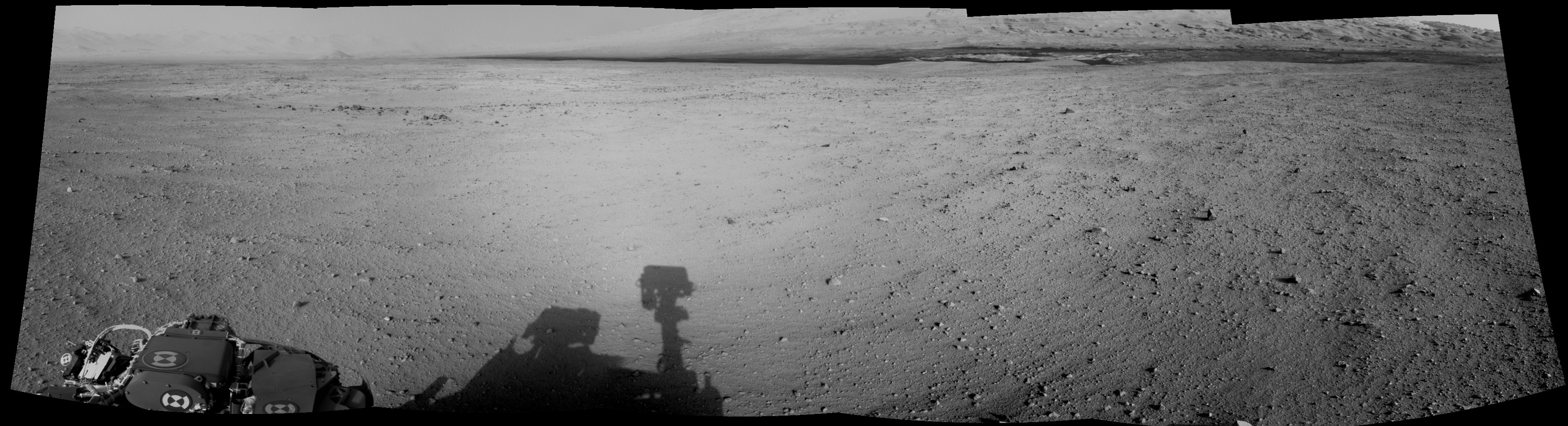
And here's a 5x1 navcam mosaic.
BTW, on MER the navcam shots were spaced 36 degrees so a whole 360deg. mosaic was composed by 10 pictures. But MSL seems to be always taking 12 images, spaced by 30 degrees although the cameras have the same FOV, IIRC. |
|
|
|
|
|
|
Sep 14 2012, 05:33 PM
Post
#14
|
|
|
Junior Member Group: Members Posts: 26 Joined: 3-August 12 Member No.: 6455 |
sorry if this has been asked but is Glenelg visible in this image and if so where? Could someone "red arrow" it?
|
|
|
|
|
Sep 14 2012, 06:03 PM
Post
#15
|
|
|
Founder Group: Chairman Posts: 14432 Joined: 8-February 04 Member No.: 1 |
QUOTE (akuo @ Sep 13 2012, 10:35 PM)  200 metres per sol is the original engineering goal for MSL, that has been mentioned in various sources. I've never seen figures that high quoted anywhere. Where do you get that number from? |
|
|
|
|
Sep 14 2012, 06:37 PM
Post
#16
|
||
 Senior Member Group: Members Posts: 2173 Joined: 28-December 04 From: Florida, USA Member No.: 132 |
QUOTE (akuo @ Sep 14 2012, 12:35 AM) 200 metres per sol is the original engineering goal for MSL... I'm guessing the 200m per sol figure is hoped-for long drive capability based on experience with the MERs. From the below, it looks like the mission requirement was for 50m per sol. "The following table summarizes some of the key resources affecting operations and the required capability for each."
http://msl-scicorner.jpl.nasa.gov/scienceplanning/ |
|
|
|
|
|
|
Sep 14 2012, 06:51 PM
Post
#17
|
|
|
Member Group: Members Posts: 470 Joined: 24-March 04 From: Finland Member No.: 63 |
QUOTE (djellison @ Sep 14 2012, 06:03 PM) I've never seen figures that high quoted anywhere. Where do you get that number from? For example in the MSL Fact Sheet: http://mars.jpl.nasa.gov/msl/news/pdfs/MSL_Fact_Sheet.pdf "...travel up to about 200 meters (660 feet) per day on Martian terrain." -------------------- Antti Kuosmanen
|
|
|
|
|
Sep 14 2012, 06:55 PM
Post
#18
|
|
 Senior Member Group: Members Posts: 1431 Joined: 26-July 08 Member No.: 4270 |
I think the difference is "designed to" vs "mission requirement."
-------------------- -- Hungry4info (Sirius_Alpha)
|
|
|
|
|
Sep 14 2012, 07:10 PM
Post
#19
|
|
|
Member Group: Members Posts: 470 Joined: 24-March 04 From: Finland Member No.: 63 |
Yeah, I didn't mean "goal" in the sense of a mission requirement. As far as I understand, the mission requirement is to survive a Martian year and to fulfil the science goal. The roving ability is there to support that.
It would be interesting to know how much of an estimated advantage in roving distance Curiosity has over MER because of the larger size - that is bigger clearance over obstacles and an ability to see further ahead for blind drivers, because of the higher elevation of the navigation cameras. -------------------- Antti Kuosmanen
|
|
|
|
| Guest_Oersted_* |
Sep 14 2012, 07:13 PM
Post
#20
|
|
Guests |
Maybe it would be good to have the starting date as the beginning of the thread title, like this: 2012-09-14. MSL drive etc etc. It is really hard to beat chronology as an organizing tool, I speak as a historian!
|
|
|
|
|
Sep 14 2012, 07:19 PM
Post
#21
|
||
|
Senior Member Group: Members Posts: 2173 Joined: 28-December 04 From: Florida, USA Member No.: 132 |
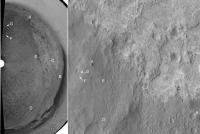
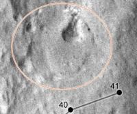
QUOTE (pmetschan @ Sep 14 2012, 12:33 PM) sorry if this has been asked but is Glenelg visible in this image and if so where? Could someone "red arrow" it? Combining jmknapp's "FWIW, the Google Mars view (based on a MOLA DEM I think) shows that Glenelg is below a rise in the foreground" image from this post (on left, rotated) with an MSL route map from here (on right). It looks like we may see it after another drive or two? (My eyeball estimate of the rise location between landing site and Glenelg circled in blue.)
|
|
|
|
|
|
|
Sep 14 2012, 07:23 PM
Post
#22
|
|
|
Senior Member Group: Members Posts: 2173 Joined: 28-December 04 From: Florida, USA Member No.: 132 |
QUOTE (akuo @ Sep 14 2012, 02:10 PM) It would be interesting to know how much of an estimated advantage in roving distance Curiosity has over MER... I'm not sure it has any advantage in terms of meters per day. MSL goes the same speed (maybe a little slower) and the extra weight takes a lot of energy to move so the time-length of drives may be similar to MER as well. The advantage may be in more freedom in choosing drive direction.
|
|
|
|
|
Sep 14 2012, 07:36 PM
Post
#23
|
||
|
Member Group: Members Posts: 866 Joined: 15-March 05 From: Santa Cruz, CA Member No.: 196 |
QUOTE (centsworth_II @ Sep 14 2012, 11:37 AM) "The following table summarizes some of the key resources affecting operations and the required capability for each.
http://msl-scicorner.jpl.nasa.gov/scienceplanning/ What surprises me is the "Rover awake Time" of 6 hours.. only six hours? with RTG power, why 'sleep' at all? (ok maybe i should read more specs) based on RTG power alone, MSL should be able to quarduple the distance per SOL over MER (Oppy's top was i think over 200 M on one SOL, If MSL did that for 24 hours, we could theoretically do a mile in 2 days instead of 8 in the optimal scenario.. |
|
|
|
|
|
|
Sep 14 2012, 07:39 PM
Post
#24
|
|
|
Senior Member Group: Members Posts: 4247 Joined: 17-January 05 Member No.: 152 |
I thought the main advantage for MSL over MER in terms of drive distance per sol was the height of the mast cameras (as akuo mentioned) and also the resolution of MC100. Both mean potential obstacles can be spotted farther away, and so longer non-blind drives can be planned. (Also there's power, which can negatively affect MER drives in times of very low solar array output).
Of course we'll just have to see what they can do with MSL. |
|
|
|
|
Sep 14 2012, 08:12 PM
Post
#25
|
|
|
Solar System Cartographer Group: Members Posts: 10162 Joined: 5-April 05 From: Canada Member No.: 227 |
"based on RTG power alone, MSL should be able to quarduple the distance per SOL over MER "
It's a mistake to think of MSL as RTG powered. Like MER it is really battery powered. The RTG just trickles power into the batteries. (as I understand it, and really I'm just repeating others here - I think Doug said pretty much exactly this). I'm nearly home and will soon be working on route maps again. East of Boston right now. Phil EDIT - east of Boston (changed it above) - not west! I have been the Enrichment Lecturer on a cruise ship. It's a tough life, but somebody has to do it. -------------------- ... because the Solar System ain't gonna map itself.
Also to be found posting similar content on https://mastodon.social/@PhilStooke Maps for download (free PD: https://upload.wikimedia.org/wikipedia/comm...Cartography.pdf NOTE: everything created by me which I post on UMSF is considered to be in the public domain (NOT CC, public domain) |
|
|
|
|
Sep 14 2012, 08:16 PM
Post
#26
|
|
 Dublin Correspondent Group: Admin Posts: 1799 Joined: 28-March 05 From: Celbridge, Ireland Member No.: 220 |
RTG power is not limitless, it's still only around 100-125watts max. MSL uses it in just the same way the MER's used their solar panels, to charge it's batteries which can then provide the power to cover the many things that MSL can and must do when she's active that add up to a lot more than 100watts of load. So she has to get her beauty sleep to recharge her batteries.
|
|
|
|
|
Sep 14 2012, 08:29 PM
Post
#27
|
|
|
Senior Member Group: Members Posts: 2920 Joined: 14-February 06 From: Very close to the Pyrénées Mountains (France) Member No.: 682 |
QUOTE (Phil Stooke @ Sep 14 2012, 10:12 PM) I'm nearly home and will soon be working on route maps again. West of Boston right now. Phil Ready for EDL I suppose! Welcome on Mars -------------------- |
|
|
|
|
Sep 14 2012, 08:38 PM
Post
#28
|
|
|
Forum Contributor Group: Members Posts: 1372 Joined: 8-February 04 From: North East Florida, USA. Member No.: 11 |
The main advantage is MSL won't have to stand down during the winter. As for returned data they did more than 500 megabits with MRO in one pass. Once out of Mars time though the team won't always be able to prepare the next days upload in time, so there will be quiet days, where I guess some safe run out science could be done. Also Mr Cook said they expect to have 10 years or more to explore. Of course they will have a "time line" to try accomplish the main mission objectives, which I suspect maybe extended beyond two years should MSL continue to be a reliable spacecraft.
What happened to Pete ?, as I see on the MSL website Cook is now the MSL Project Manager. Edit : Wiki says this... "He is currently director for the Engineering and Science Directorate at the Jet Propulsion Laboratory." I guess Pete Theisinger got promoted .
|
|
|
|
|
Sep 14 2012, 09:35 PM
Post
#29
|
|
|
Founder Group: Chairman Posts: 14432 Joined: 8-February 04 Member No.: 1 |
QUOTE (Phil Stooke @ Sep 14 2012, 01:12 PM) It's a mistake to think of MSL as RTG powered. Like MER it is really battery powered. The RTG just trickles power into the batteries. (as I understand it, and really I'm just repeating others here - I think Doug said pretty much exactly this). Exactly that. It consumes more than 110Watts to 'run' the rover - and some activities use much much more than that. You use up battery power during the day, and then recharge with the RTG over night. QUOTE (MahFL) What happened to Pete ?, as I see on the MSL website Cook is now the MSL Project Manager. That information is probably out of date. Richard was MSL ProjMang for a while a few years back as Pete had some medical issues to deal with. Then Pete took the position again. At the moment, it's still Pete at the top and Richard as his deputy. |
|
|
|
|
Sep 14 2012, 10:07 PM
Post
#30
|
|
|
Member Group: Members Posts: 166 Joined: 20-September 05 From: North Texas Member No.: 503 |
QUOTE (Oersted @ Sep 14 2012, 07:13 PM) Maybe it would be good to have the starting date as the beginning of the thread title, like this: 2012-09-14. MSL drive etc etc. It is really hard to beat chronology as an organizing tool, I speak as a historian! Or perhaps when each thread is closed, an admin can change the title, with a prefix, such as "Sol 34 - Sol 58, Drive, Drive, Drive toward Glenelg". |
|
|
|
|
Sep 14 2012, 10:12 PM
Post
#31
|
|
|
Member Group: Members Posts: 166 Joined: 20-September 05 From: North Texas Member No.: 503 |
QUOTE (MahFL @ Sep 14 2012, 08:38 PM) The main advantage is MSL won't have to stand down during the winter. Another advantage... no real worry about tau. Although dust storms will still be a concern for some of the instruments; keeping lens covers in place for instance. |
|
|
|
|
Sep 14 2012, 11:00 PM
Post
#32
|
|
|
Member Group: Admin Posts: 976 Joined: 29-September 06 From: Pasadena, CA - USA Member No.: 1200 |
QUOTE (fredk @ Sep 14 2012, 11:39 AM) I thought the main advantage for MSL over MER in terms of drive distance per sol was the height of the mast cameras (as akuo mentioned) and also the resolution of MC100. Both mean potential obstacles can be spotted farther away, and so longer non-blind drives can be planned. (Also there's power, which can negatively affect MER drives in times of very low solar array output). Of course we'll just have to see what they can do with MSL. NAVCAMs have a higher vantage point and wider baseline and they yield good range data to 30-40 meters. MASTCAMs are yet to be used for driving. They have a narrow field of view so we would need more frames to cover an area similar to PANCAMs. Moreover, the foreshortening would still limit our visibility of potential obstacles. I doubt we will be able to extend MSL blind driving much beyond what MER did. The real advantage on MSL is the more powerful processor that should speed up VO and AutoNav driving. Paolo -------------------- Disclaimer: all opinions, ideas and information included here are my own,and should not be intended to represent opinion or policy of my employer.
|
|
|
|
|
Sep 14 2012, 11:03 PM
Post
#33
|
|
|
Member Group: Admin Posts: 976 Joined: 29-September 06 From: Pasadena, CA - USA Member No.: 1200 |
QUOTE (DFinfrock @ Sep 14 2012, 02:12 PM) Another advantage... no real worry about tau. Although dust storms will still be a concern for some of the instruments; keeping lens covers in place for instance. Both Winter and Tau will affect the heating requirements therefore reducing amount of science and drive/arm time. Paolo -------------------- Disclaimer: all opinions, ideas and information included here are my own,and should not be intended to represent opinion or policy of my employer.
|
|
|
|
|
Sep 14 2012, 11:43 PM
Post
#34
|
|
|
Forum Contributor Group: Members Posts: 1372 Joined: 8-February 04 From: North East Florida, USA. Member No.: 11 |
QUOTE (RoverDriver @ Sep 14 2012, 11:03 PM) Both Winter and Tau will affect the heating requirements therefore reducing amount of science and drive/arm time. Paolo Early on they did say MSL was little warmer than expected, which would mean slightly less power needed for heaters in the winter. The external actuators though would still need the normal amount of heating. |
|
|
|
|
Sep 15 2012, 12:22 AM
Post
#35
|
||
 Member Group: Members Posts: 222 Joined: 7-August 12 From: Garberville, CA Member No.: 6500 |
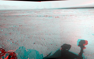
"On the Road Again" anaglyphs from Sol 38:
-------------------- "We shall not cease from exploration, and the end of all our exploring will be to arrive where we started and know the place for the first time." -T.S. Eliot
|
|
|
|
|
|
|
Sep 15 2012, 07:04 AM
Post
#36
|
|
|
Senior Member Group: Moderator Posts: 4279 Joined: 19-April 05 From: .br at .es Member No.: 253 |
QUOTE (DFinfrock @ Sep 15 2012, 12:07 AM) Or perhaps when each thread is closed, an admin can change the title, with a prefix, such as "Sol 34 - Sol 58, Drive, Drive, Drive toward Glenelg". That's nice but redundant because it is already included on each topic's description. Check the second (and smaller) line below each thread's title here. |
|
|
|
|
Sep 15 2012, 12:25 PM
Post
#37
|
|
|
Senior Member Group: Members Posts: 2920 Joined: 14-February 06 From: Very close to the Pyrénées Mountains (France) Member No.: 682 |
QUOTE (MahFL @ Sep 15 2012, 01:43 AM) Early on they did say MSL was little warmer than expected, which would mean slightly less power needed for heaters in the winter. The external actuators though would still need the normal amount of heating. I think it was because temperatures at Gale were slightly higher than expected..? -------------------- |
|
|
|
|
Sep 15 2012, 01:22 PM
Post
#38
|
||
|
Senior Member Group: Moderator Posts: 3431 Joined: 11-August 04 From: USA Member No.: 98 |
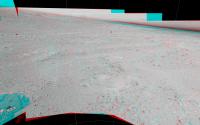
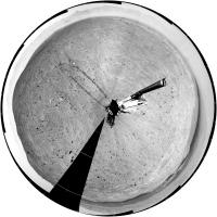
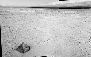
Another drive on sol 39. Looks like we are approaching a little scenic overlook, maybe?
Attached thumbnail(s)
|
|
|
|
|
|
|
Sep 15 2012, 04:04 PM
Post
#39
|
|
|
Member Group: Admin Posts: 976 Joined: 29-September 06 From: Pasadena, CA - USA Member No.: 1200 |
QUOTE (MahFL @ Sep 14 2012, 03:43 PM) Early on they did say MSL was little warmer than expected, which would mean slightly less power needed for heaters in the winter. The external actuators though would still need the normal amount of heating. Yes, Gale is a little warmer than we thought and we also have a bit more power than anticipated but that does not mean that for *driving* the Winter heating requirements are going to be more taxing. Currently we are not power limited but once the RTG starts to slow down, there will be differences between seasons. We'll see how much impact it will be. Paolo -------------------- Disclaimer: all opinions, ideas and information included here are my own,and should not be intended to represent opinion or policy of my employer.
|
|
|
|
|
Sep 16 2012, 12:13 AM
Post
#40
|
||
|
Senior Member Group: Members Posts: 2920 Joined: 14-February 06 From: Very close to the Pyrénées Mountains (France) Member No.: 682 |
QUOTE (centsworth_II @ Sep 14 2012, 08:37 PM) I'm guessing the 200m per sol figure is hoped-for long drive capability based on experience with the MERs. From the below, it looks like the mission requirement was for 50m per sol. "The following table summarizes some of the key resources affecting operations and the required capability for each."
http://msl-scicorner.jpl.nasa.gov/scienceplanning/ You know what? In this week issue of Aviation Week they wrote 40km (25 miles) a day! Ok that's a tipo...I wouldn't risk to put this remark in the "Bad reporting" topic! Well may be in "MSL Humor" one 
-------------------- |
|
|
|
|
|
|
Sep 16 2012, 12:20 AM
Post
#41
|
|||
|
Junior Member Group: Members Posts: 54 Joined: 10-August 11 Member No.: 6119 |
A couple of Navcam flicker gifs from Sol 38...
|
||
|
|
|
||
|
Sep 16 2012, 08:36 AM
Post
#42
|
||
|
The Poet Dude Group: Moderator Posts: 5551 Joined: 15-March 04 From: Kendal, Cumbria, UK Member No.: 60 |
Colour 2 frame mosaic close-up of part of the first of JB's gifs...
Such gorgeous detail and colour. Just wish I knew more geology... -------------------- |
|
|
|
|
|
|
Sep 16 2012, 09:23 AM
Post
#43
|
||
 Member Group: Members Posts: 112 Joined: 20-August 12 From: Spain Member No.: 6597 |
Wow, this layer looks amazing! I can't tell the origin of it, but it lacks (as far as I can see) internal sorting. It could be a lot of things: tuff, debris flow depopsit, a breccia... we need to have a closer (and compositional) look at it
 QUOTE (Stu @ Sep 16 2012, 09:36 AM) Colour 2 frame mosaic close-up of part of the first of JB's gifs...
Such gorgeous detail and colour. Just wish I knew more geology... |
|
|
|
|
|
|
Sep 16 2012, 02:37 PM
Post
#44
|
||
|
Senior Member Group: Members Posts: 4247 Joined: 17-January 05 Member No.: 152 |
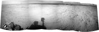
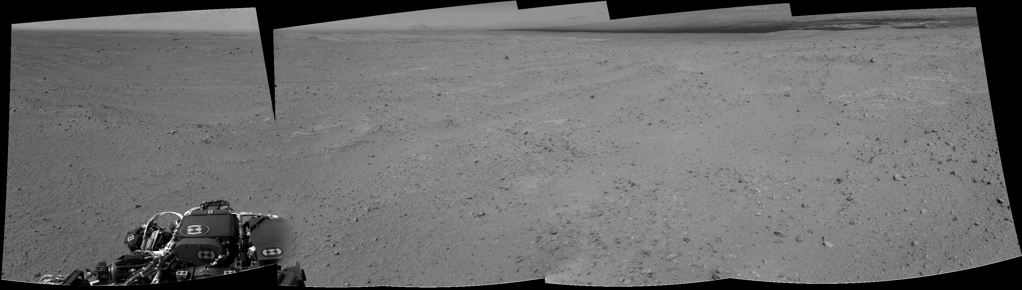
After the sol40 drive, I think we've now got a pretty clear view onto Glenelg - here's a navcam anaglyph:
|
|
|
|
|
|
|
Sep 16 2012, 02:38 PM
Post
#45
|
||
|
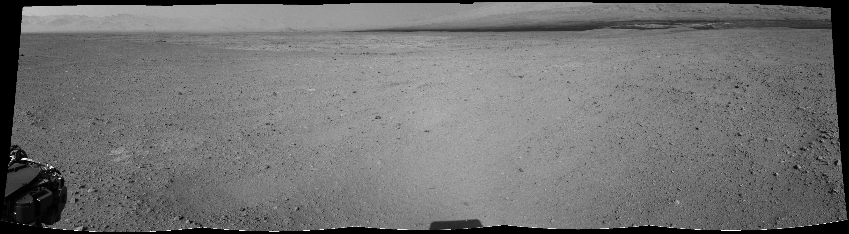
Senior Member Group: Moderator Posts: 3431 Joined: 11-August 04 From: USA Member No.: 98 |
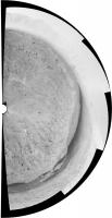
Sol 40.
Attached thumbnail(s)
|
|
|
|
|
|
|
Sep 16 2012, 02:38 PM
Post
#46
|
|
 Senior Member Group: Members Posts: 1619 Joined: 12-February 06 From: Bergerac - FR Member No.: 678 |
Sol 39 Navcam pan.
-------------------- |
|
|
|
|
Sep 16 2012, 03:08 PM
Post
#47
|
|
|
Member Group: Members Posts: 470 Joined: 24-March 04 From: Finland Member No.: 63 |
Is anybody attempting to map Curie's positions on sol 39&40? Doing this by eye seems to be more difficult than with MER, since the strategy seems to be to image 360 degrees of navcam thumbnails and full resolution only in the drive direction.
Great to see three sols of back-to-back driving though -------------------- Antti Kuosmanen
|
|
|
|
|
Sep 16 2012, 03:12 PM
Post
#48
|
|
|
Founder Group: Chairman Posts: 14432 Joined: 8-February 04 Member No.: 1 |
QUOTE (akuo @ Sep 16 2012, 08:08 AM) Is anybody attempting to map Curie's positions on sol 39&40? Obviously the team at JPL are doing just that, and the amateur efforts will appear here when people have had the time to figure it out http://www.unmannedspaceflight.com/index.p...20&start=20 |
|
|
|
|
Sep 16 2012, 03:40 PM
Post
#49
|
||
|
Senior Member Group: Members Posts: 1619 Joined: 12-February 06 From: Bergerac - FR Member No.: 678 |
And Sol 40 panoramics. The last with some extra-sky
Attached thumbnail(s)
-------------------- |
|
|
|
|
|
|
Sep 16 2012, 04:03 PM
Post
#50
|
|
|
Solar System Cartographer Group: Members Posts: 10162 Joined: 5-April 05 From: Canada Member No.: 227 |
"Is anybody attempting to map Curie's positions"
Phil reporting from Logan Airport in Boston... finally on my way home. I was just downloading all the nice pans from Ant and others, and by tomorrow I will be busy reprojecting them and estimating locations. Look for a route map update very soon. Right now I am especially interested in any placenames - rock names, Chemcam target names etc. that may have popped up in twitter feeds etc. while my access has been very limited. If anyone has seen anything and can alert me to them \i would appreciate it. Phil -------------------- ... because the Solar System ain't gonna map itself.
Also to be found posting similar content on https://mastodon.social/@PhilStooke Maps for download (free PD: https://upload.wikimedia.org/wikipedia/comm...Cartography.pdf NOTE: everything created by me which I post on UMSF is considered to be in the public domain (NOT CC, public domain) |
|
|
|
|
Sep 16 2012, 04:32 PM
Post
#51
|
|
|
Senior Member Group: Moderator Posts: 4279 Joined: 19-April 05 From: .br at .es Member No.: 253 |
QUOTE (akuo @ Sep 16 2012, 05:08 PM) ... the strategy seems to be to image 360 degrees of navcam thumbnails and full resolution only in the drive direction. Not really. If you see a thumbnail almost sure the full-res is there too. It's just a question of downlink queue priorities. The drive-direction images take a higher one while the backwards-looking ones have low prio. |
|
|
|
|
Sep 16 2012, 04:49 PM
Post
#52
|
|
|
Senior Member Group: Moderator Posts: 3431 Joined: 11-August 04 From: USA Member No.: 98 |
QUOTE (Tesheiner @ Sep 16 2012, 09:32 AM) Not really. If you see a thumbnail almost sure the full-res is there too. It's just a question of downlink queue priorities. The drive-direction images take a higher one while the backwards-looking ones have low prio. I'd add that this is exactly how it's always worked with MER, except with MER we never got to see the thumbnails on the main raw images page. So this is a nice enhancement, a kind of 'preview' just like the rover team gets. |
|
|
|
|
Sep 16 2012, 08:57 PM
Post
#53
|
|
|
Member Group: Members Posts: 222 Joined: 7-August 12 From: Garberville, CA Member No.: 6500 |
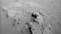
Just down within the hour... Six additional full res MC100 frames to fill out the surrounding areas of the interesting Sol 39 Rock formation. Oh my, there's some truly glorious detail in there...

-------------------- "We shall not cease from exploration, and the end of all our exploring will be to arrive where we started and know the place for the first time." -T.S. Eliot
|
|
|
|
|
Sep 16 2012, 10:13 PM
Post
#54
|
|
 Senior Member Group: Members Posts: 1088 Joined: 19-February 05 From: Close to Meudon Observatory in France Member No.: 172 |
QUOTE (Ant103 @ Sep 16 2012, 05:40 PM) And Sol 40 panoramics. The last with some extra-sky How nice ! Thanks a lot Ant 103 for sharing it with us... |
|
|
|
|
Sep 16 2012, 11:43 PM
Post
#55
|
|
|
Senior Member Group: Members Posts: 1619 Joined: 12-February 06 From: Bergerac - FR Member No.: 678 |
And here's my take
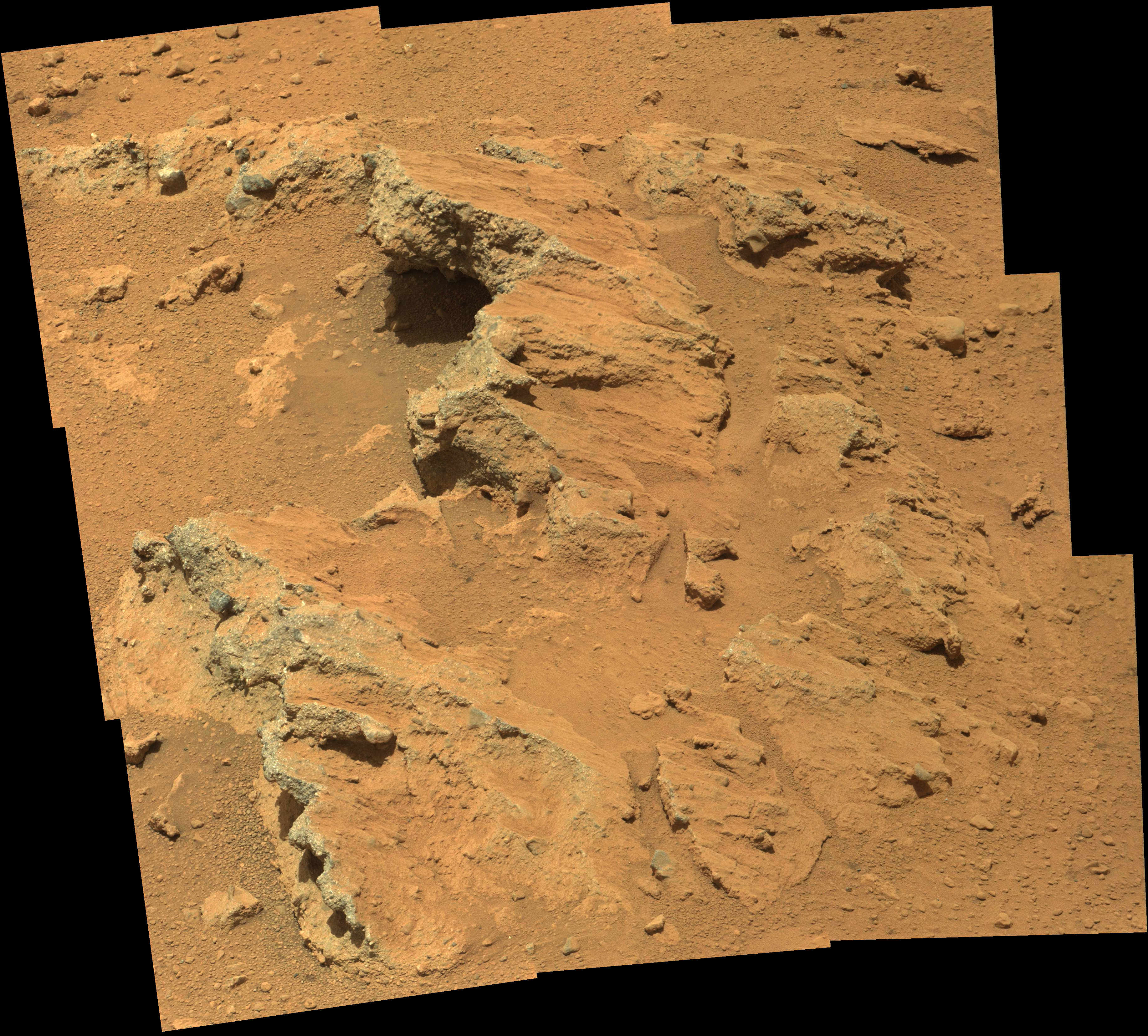 Yes, some good details there, a beautiful rock indeed .Thank you Olivier
-------------------- |
|
|
|
|
Sep 17 2012, 12:57 AM
Post
#56
|
|
 Senior Member Group: Members Posts: 1465 Joined: 9-February 04 From: Columbus OH USA Member No.: 13 |
QUOTE (Ant103 @ Sep 16 2012, 06:43 PM) And here's my take It'd be good to see some ML shots to get 3D views of that. The bedrock or whatever it is kind of looks like asphalt. It seems to be very erodable by the wind/sand, so the pebbles are eroding out of it? -------------------- |
|
|
|
|
Sep 17 2012, 01:27 AM
Post
#57
|
|
 Senior Member Group: Moderator Posts: 2785 Joined: 10-November 06 From: Pasadena, CA Member No.: 1345 |
Very rounded pebbles and cobbles, I might add....
-------------------- Some higher resolution images available at my photostream: http://www.flickr.com/photos/31678681@N07/
|
|
|
|
|
Sep 17 2012, 01:42 AM
Post
#58
|
|||
|
Solar System Cartographer Group: Members Posts: 10162 Joined: 5-April 05 From: Canada Member No.: 227 |
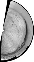
This is Ant103's sol 40 pan in a circular format. I hope we will get the rest of it, but a few points can be matched to HiRISE. The black rock at upper centre is the very prominent block about 200m east of the landing site. Glenelg shows up well, and a prominent crater south of the lighter terrain unit can be seen easily. I have added a key to some of these. (I have not necessarily made the angle of the half-panorama correct, I'll check it later)
Phil
-------------------- ... because the Solar System ain't gonna map itself.
Also to be found posting similar content on https://mastodon.social/@PhilStooke Maps for download (free PD: https://upload.wikimedia.org/wikipedia/comm...Cartography.pdf NOTE: everything created by me which I post on UMSF is considered to be in the public domain (NOT CC, public domain) |
||
|
|
|
||
|
Sep 17 2012, 01:49 AM
Post
#59
|
|
|
Senior Member Group: Members Posts: 2998 Joined: 30-October 04 Member No.: 105 |
QUOTE (Juramike) Very rounded pebbles and cobbles Yes indeed, sir. Nice clastics. --Bill -------------------- |
|
|
|
|
Sep 17 2012, 02:52 PM
Post
#60
|
|||
|
The Poet Dude Group: Moderator Posts: 5551 Joined: 15-March 04 From: Kendal, Cumbria, UK Member No.: 60 |
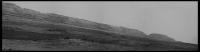
Rather gorgeous view of the foothills of Mt Sharp now...
...and some fascinating geology in view now, too...
-------------------- |
||
|
|
|
||
|
Sep 17 2012, 03:11 PM
Post
#61
|
|
|
Senior Member Group: Moderator Posts: 3431 Joined: 11-August 04 From: USA Member No.: 98 |
|
|
|
|
|
Sep 17 2012, 05:15 PM
Post
#62
|
||
|
Senior Member Group: Members Posts: 2920 Joined: 14-February 06 From: Very close to the Pyrénées Mountains (France) Member No.: 682 |
QUOTE (Stu @ Sep 17 2012, 04:52 PM) ...and some fascinating geology in view now, too...
According to Phil, 3 posts higher, that's Glenelg that's showing. -------------------- |
|
|
|
|
|
|
Sep 17 2012, 05:27 PM
Post
#63
|
|
|
Senior Member Group: Members Posts: 4247 Joined: 17-January 05 Member No.: 152 |
Stu's two mosaics (and Ed's in the other thread) actually fit together, so Stu's colour one is not Glenelg, but towards the west.
|
|
|
|
|
Sep 17 2012, 06:20 PM
Post
#64
|
||
|
Solar System Cartographer Group: Members Posts: 10162 Joined: 5-April 05 From: Canada Member No.: 227 |
This is the sol 39 half panorama reprojected.
Phil
-------------------- ... because the Solar System ain't gonna map itself.
Also to be found posting similar content on https://mastodon.social/@PhilStooke Maps for download (free PD: https://upload.wikimedia.org/wikipedia/comm...Cartography.pdf NOTE: everything created by me which I post on UMSF is considered to be in the public domain (NOT CC, public domain) |
|
|
|
|
|
|
Sep 17 2012, 06:39 PM
Post
#65
|
|
|
Senior Member Group: Moderator Posts: 3431 Joined: 11-August 04 From: USA Member No.: 98 |
QUOTE (fredk @ Sep 17 2012, 11:27 AM) Stu's two mosaics (and Ed's in the other thread) actually fit together, so Stu's colour one is not Glenelg, but towards the west. Specifically here |
|
|
|
|
Sep 17 2012, 07:37 PM
Post
#66
|
|
|
Junior Member Group: Members Posts: 30 Joined: 7-March 04 Member No.: 51 |
It looks like a small outcrop of the high TI unit 100+ m south of Bradbury Landing. It shows up well in this MRO image from Emily's blog.
https://planetary.s3.amazonaws.com/assets/i...29_PIA16148.jpg |
|
|
|
|
Sep 17 2012, 08:33 PM
Post
#67
|
|||
|
Solar System Cartographer Group: Members Posts: 10162 Joined: 5-April 05 From: Canada Member No.: 227 |
A couple more reprojected panoramas to help with locations. The full circle is from sol 29 but as the rover was still here on the morning of sol 38 I can slip it in here (to keep them all together).
Phil Sols 29-37:
Sol 38:
-------------------- ... because the Solar System ain't gonna map itself.
Also to be found posting similar content on https://mastodon.social/@PhilStooke Maps for download (free PD: https://upload.wikimedia.org/wikipedia/comm...Cartography.pdf NOTE: everything created by me which I post on UMSF is considered to be in the public domain (NOT CC, public domain) |
||
|
|
|
||
|
Sep 18 2012, 04:59 AM
Post
#68
|
|
 Senior Member Group: Members Posts: 2228 Joined: 1-December 04 From: Marble Falls, Texas, USA Member No.: 116 |
-------------------- ...Tom
I'm not a Space Fan, I'm a Space Exploration Enthusiast. |
|
|
|
|
Sep 18 2012, 11:29 AM
Post
#69
|
||
|
Senior Member Group: Moderator Posts: 4279 Joined: 19-April 05 From: .br at .es Member No.: 253 |
QUOTE (mhoward @ Sep 17 2012, 05:11 PM) Sol 41, another step closer. A navcam mosaic.
|
|
|
|
|
|
|
Sep 18 2012, 12:22 PM
Post
#70
|
|
|
Member Group: Members Posts: 470 Joined: 24-March 04 From: Finland Member No.: 63 |
Sol 42 drive images are up. The shadows are long and the dynamic range in the navcam images appears quite high. We've been roving late into the afternoon?
-------------------- Antti Kuosmanen
|
|
|
|
|
Sep 18 2012, 12:30 PM
Post
#71
|
|
|
Senior Member Group: Members Posts: 1465 Joined: 9-February 04 From: Columbus OH USA Member No.: 13 |
QUOTE (akuo @ Sep 18 2012, 08:22 AM) Sol 42 drive images are up. The shadows are long and the dynamic range in the navcam images appears quite high. We've been roving late into the afternoon? About 3:30pm LMST, about 2 hours before sunset. The sun is practically just directly behind the camera in the highest-contrast ones, which might explain the brightness toward the center (backscatter). -------------------- |
|
|
|
|
Sep 18 2012, 12:40 PM
Post
#72
|
|
|
Member Group: Members Posts: 282 Joined: 18-June 04 Member No.: 84 |
They look very "MER" like now....and different JPEG compression? Look at the horizon/sky
http://mars.jpl.nasa.gov/msl-raw-images/pr...NCAM00427M_.JPG http://mars.jpl.nasa.gov/msl-raw-images/pr...NCAM00427M_.JPG Compare to this from Spirit on SOL 74 NAVCAM: http://marsrovers.jpl.nasa.gov/gallery/all...00P1827R0M1.JPG |
|
|
|
|
Sep 18 2012, 01:41 PM
Post
#73
|
|
|
Senior Member Group: Members Posts: 2920 Joined: 14-February 06 From: Very close to the Pyrénées Mountains (France) Member No.: 682 |
QUOTE (fredk @ Sep 17 2012, 07:27 PM) Stu's two mosaics (and Ed's in the other thread) actually fit together, so Stu's colour one is not Glenelg, but towards the west. Sorry Stu & All, my bad. -------------------- |
|
|
|
|
Sep 18 2012, 02:09 PM
Post
#74
|
||
|
Solar System Cartographer Group: Members Posts: 10162 Joined: 5-April 05 From: Canada Member No.: 227 |
Sol 41 half-panorama reprojected. This enables a very good match to topography, confirming the previous estimate (or very near it) despite me saying it might have to change in the route map thread. But sol 40 had to be changed, as the new map shows.
Phil
-------------------- ... because the Solar System ain't gonna map itself.
Also to be found posting similar content on https://mastodon.social/@PhilStooke Maps for download (free PD: https://upload.wikimedia.org/wikipedia/comm...Cartography.pdf NOTE: everything created by me which I post on UMSF is considered to be in the public domain (NOT CC, public domain) |
|
|
|
|
|
|
Sep 18 2012, 02:49 PM
Post
#75
|
|||
 Senior Member Group: Members Posts: 3419 Joined: 9-February 04 From: Minneapolis, MN, USA Member No.: 15 |
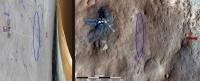
I'm assuming that the marked areas in the next two images, from above and from the surface, are the same feature?
From above, this feature looks, at first glance, to have a crater morphology (until you look closely and see that its edges are in positive, rather than negative, relief). From the ground, it kind of resembles a miniature version of Home Plate. As Stu said -- fascinating geology. Almost looks like a sedimentary process laid down a fill inside a small crater which has been more resistant to erosion than the surface in which the crater was originally formed. -the other Doug -------------------- The trouble ain't that there is too many fools, but that the lightning ain't distributed right. -Mark Twain
|
||
|
|
|
||
|
Sep 18 2012, 03:06 PM
Post
#76
|
|
|
Senior Member Group: Moderator Posts: 3431 Joined: 11-August 04 From: USA Member No.: 98 |
From Sol 42:
  |
|
|
|
|
Sep 18 2012, 03:19 PM
Post
#77
|
|
|
Senior Member Group: Members Posts: 4247 Joined: 17-January 05 Member No.: 152 |
QUOTE (dvandorn @ Sep 18 2012, 02:49 PM) I'm assuming that the marked areas in the next two images, from above and from the surface, are the same feature? Nope - that mastcam mosaic is looking west.
|
|
|
|
|
Sep 18 2012, 03:29 PM
Post
#78
|
|
|
Senior Member Group: Members Posts: 3419 Joined: 9-February 04 From: Minneapolis, MN, USA Member No.: 15 |
QUOTE (fredk @ Sep 18 2012, 10:19 AM) Nope - that mastcam mosaic is looking west. Okay. In that case, I'm finding it really difficult finding the feature in the surface image in the overhead context. And, correct me if I'm wrong, but while the feature I marked in the overhead was more north of us at the Sol 40 position, is it not west-northwest of us now? I suppose the mastcam mosaic in question was taken well before either of those two stops, though. Ah, well. The surface feature still looks interestingly like some kind of cemented underfloor. -the other Doug -------------------- The trouble ain't that there is too many fools, but that the lightning ain't distributed right. -Mark Twain
|
|
|
|
|
Sep 18 2012, 04:02 PM
Post
#79
|
|
|
Solar System Cartographer Group: Members Posts: 10162 Joined: 5-April 05 From: Canada Member No.: 227 |
Doug - see my route map... the outcrop is due south of the sol 24 position near the SW corner of my map. I suppose it might be looked at on the way back from Glenelg towards the main science area to the west.
Phil -------------------- ... because the Solar System ain't gonna map itself.
Also to be found posting similar content on https://mastodon.social/@PhilStooke Maps for download (free PD: https://upload.wikimedia.org/wikipedia/comm...Cartography.pdf NOTE: everything created by me which I post on UMSF is considered to be in the public domain (NOT CC, public domain) |
|
|
|
|
Sep 18 2012, 04:04 PM
Post
#80
|
|
|
Senior Member Group: Members Posts: 2173 Joined: 28-December 04 From: Florida, USA Member No.: 132 |
QUOTE (dvandorn @ Sep 18 2012, 10:29 AM) Okay. In that case, I'm finding it really difficult finding the feature.... Did you check the image linked here?
|
|
|
|
|
Sep 18 2012, 04:24 PM
Post
#81
|
|
 Member Group: Members Posts: 276 Joined: 11-December 07 From: Dar es Salaam, Tanzania Member No.: 3978 |
QUOTE (akuo @ Sep 18 2012, 03:22 PM) Sol 42 drive images are up. The shadows are long and the dynamic range in the navcam images appears quite high. We've been roving late into the afternoon? I actually thought there had been a change in the camera's default brightness/contrast settings!
-------------------- |
|
|
|
|
Sep 18 2012, 04:24 PM
Post
#82
|
|
|
Senior Member Group: Members Posts: 3419 Joined: 9-February 04 From: Minneapolis, MN, USA Member No.: 15 |
QUOTE (Phil Stooke @ Sep 18 2012, 11:02 AM) Doug - see my route map... the outcrop is due south of the sol 24 position near the SW corner of my map. Thanks! It can be a little difficult recognizing these flat-to-the-ground features from above, can't it? -the other Doug -------------------- The trouble ain't that there is too many fools, but that the lightning ain't distributed right. -Mark Twain
|
|
|
|
|
Sep 18 2012, 04:39 PM
Post
#83
|
|
|
Member Group: Members Posts: 470 Joined: 24-March 04 From: Finland Member No.: 63 |
QUOTE (Doc @ Sep 18 2012, 04:24 PM) I actually thought there had been a change in the camera's default brightness/contrast settings! While the lighting conditions do have an effect, the thinking is that there has been change to the contrast stretch and jpeg quality in the released "raw" images. See the discussion here: http://www.unmannedspaceflight.com/index.p...mp;#entry191664 -------------------- Antti Kuosmanen
|
|
|
|
|
Sep 18 2012, 05:31 PM
Post
#84
|
||
|
Senior Member Group: Members Posts: 1074 Joined: 21-September 07 From: Québec, Canada Member No.: 3908 |
Here is a wider panorama of sol 42 navcams:
There is something I don't understand on the MSL raw images page:http://mars.jpl.nasa.gov/msl/multimedia/raw/. The number of images in the list does not reflect the actual number of images visible. For example, for the front hazcam the list says "Sol 042 (4 img)". When I click on the link, I see only one "Full data product" and one "Thumbnail data product". This happens in many places. I'm just curious to know the reason for the discrepancy. |
|
|
|
|
|
|
Sep 18 2012, 05:32 PM
Post
#85
|
|
|
Senior Member Group: Members Posts: 1619 Joined: 12-February 06 From: Bergerac - FR Member No.: 678 |
So, even if this tosol pics are to stretched from my point of view, here is the Sol 42 navcam panoramic.
 I had to be a little bit more stronger with processing, in order to retrieve a much better imagery. -------------------- |
|
|
|
|
Sep 18 2012, 06:16 PM
Post
#86
|
||
|
Solar System Cartographer Group: Members Posts: 10162 Joined: 5-April 05 From: Canada Member No.: 227 |
... and the previous nice pan by Ant103 reprojected.
Phil
-------------------- ... because the Solar System ain't gonna map itself.
Also to be found posting similar content on https://mastodon.social/@PhilStooke Maps for download (free PD: https://upload.wikimedia.org/wikipedia/comm...Cartography.pdf NOTE: everything created by me which I post on UMSF is considered to be in the public domain (NOT CC, public domain) |
|
|
|
|
|
|
Sep 18 2012, 06:32 PM
Post
#87
|
||
|
Member Group: Members Posts: 276 Joined: 11-December 07 From: Dar es Salaam, Tanzania Member No.: 3978 |
Seeing the navigation images are coming down in sets of 5 showing the same view for the past few sols, I tried stitching them all up and put together a (rough) animation to see our progress from the ground.
It is rather small so apologies for that. The full version will be on my blog in time. -------------------- |
|
|
|
|
|
|
Sep 18 2012, 07:38 PM
Post
#88
|
|
|
Member Group: Members Posts: 813 Joined: 29-December 05 From: NE Oh, USA Member No.: 627 |
http://www.nasa.gov/news/media/newsaudio/index.html NASA Hosts Teleconference About Mars Curiosity Rover Progress Wednesday, Sept. 19 at 2 p.m. EDT NASA will host a media teleconference to provide a status update on the Curiosity rover's mission to Mars' Gale Crater. Curiosity, the Mars Science Laboratory, is 43 days into a two-year mission to investigate whether conditions may have been favorable for microbial life. For teleconference dial-in information, reporters must send their name, media affiliation and telephone number to Elena Mejia at elena.mejia@jpl.nasa.gov or call NASA's Jet Propulsion Laboratory Media Relations Office at 818-354-5011. Note: A UStream player with audio of the briefing will appear here shortly before the event. Visuals supporting the briefing are/will be available at http://go.nasa.gov/curiositytelecon. |
|
|
|
|
Sep 19 2012, 05:42 AM
Post
#89
|
|
|
Member Group: Members Posts: 139 Joined: 14-October 05 From: Toronto, Canada Member No.: 529 |
JPL has been posting updates on the MSL project page.
http://mars.jpl.nasa.gov/msl/news/whatsnew/... What is interesting is that on September 17th, the use of DAN was part of the regular drive sequence. QUOTE On Sol 41, Curiosity logged 89 feet (27 meters), across the surface of Gale Crater. During this sol, for the first time, the DAN instrument (the Dynamic Albedo of Neutrons investigation) was incorporated into the rover's drive sequence.
-------------------- -- Robin
|
|
|
|
|
Sep 19 2012, 02:09 PM
Post
#90
|
|
|
Member Group: Admin Posts: 976 Joined: 29-September 06 From: Pasadena, CA - USA Member No.: 1200 |
We have been doinc DAN observations while driving for the past three drives already. Two observations on each drive.
Paolo -------------------- Disclaimer: all opinions, ideas and information included here are my own,and should not be intended to represent opinion or policy of my employer.
|
|
|
|
|
Sep 19 2012, 04:03 PM
Post
#91
|
|||
|
Member Group: Members Posts: 222 Joined: 7-August 12 From: Garberville, CA Member No.: 6500 |
Sol 43... Not sure what the science team has christened this one with yet, but "Little Egypt" seems about right to me....
...and a closer look:
-------------------- "We shall not cease from exploration, and the end of all our exploring will be to arrive where we started and know the place for the first time." -T.S. Eliot
|
||
|
|
|
||
|
Sep 19 2012, 04:48 PM
Post
#92
|
|
|
Senior Member Group: Moderator Posts: 3431 Joined: 11-August 04 From: USA Member No.: 98 |
As we can see from the hazcam view, the rock (whatever it will be called) is basically dead ahead.
  And to the left: 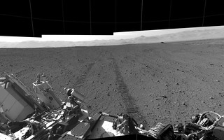 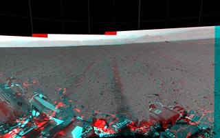 |
|
|
|
|
Sep 19 2012, 05:10 PM
Post
#93
|
||
|
Senior Member Group: Members Posts: 1074 Joined: 21-September 07 From: Québec, Canada Member No.: 3908 |
Sol 43 navcam panorama:
(I'm having some trouble getting Photoshop to produce a straight horizon.) |
|
|
|
|
|
|
Sep 19 2012, 05:35 PM
Post
#94
|
|
|
Senior Member Group: Members Posts: 1465 Joined: 9-February 04 From: Columbus OH USA Member No.: 13 |
So is that the rock chosen to be the first APXS, etc. subject? They've been saying they're looking for a "fine-grained" specimen for whatever reason and one that can stand to be pushed against with some force. Why do they need x amount of force?
-------------------- |
|
|
|
|
Sep 19 2012, 05:38 PM
Post
#95
|
|
|
Solar System Cartographer Group: Members Posts: 10162 Joined: 5-April 05 From: Canada Member No.: 227 |
For brushing and/or drilling.
I'm not sure this is big enough. (EDIT - guess it is!) Phil -------------------- ... because the Solar System ain't gonna map itself.
Also to be found posting similar content on https://mastodon.social/@PhilStooke Maps for download (free PD: https://upload.wikimedia.org/wikipedia/comm...Cartography.pdf NOTE: everything created by me which I post on UMSF is considered to be in the public domain (NOT CC, public domain) |
|
|
|
|
Sep 19 2012, 06:03 PM
Post
#96
|
|
 Senior Member Group: Members Posts: 1729 Joined: 3-August 06 From: 43° 35' 53" N 1° 26' 35" E Member No.: 1004 |
rock is apparently called 'Jake Matijevic' and will be the first target for contact science
http://www.nasa.gov/mission_pages/msl/mult...a/pia16155.html |
|
|
|
|
Sep 19 2012, 06:18 PM
Post
#97
|
|
 Member Group: Members Posts: 700 Joined: 3-December 04 From: Boulder, Colorado, USA Member No.: 117 |
I was surprised to see how big that rock is- about a foot across. After years of mentally correcting for the fact that objects in MER images are smaller than they appear, I need to recalibrate.
John |
|
|
|
|
Sep 19 2012, 06:26 PM
Post
#98
|
|
|
Senior Member Group: Members Posts: 2920 Joined: 14-February 06 From: Very close to the Pyrénées Mountains (France) Member No.: 682 |
Do you have any audio right now? I don't
-------------------- |
|
|
|
|
Sep 19 2012, 06:26 PM
Post
#99
|
|
|
Senior Member Group: Members Posts: 1729 Joined: 3-August 06 From: 43° 35' 53" N 1° 26' 35" E Member No.: 1004 |
yep! here in Haute Garonne audio is fine
|
|
|
|
|
Sep 19 2012, 06:29 PM
Post
#100
|
|
|
Senior Member Group: Members Posts: 2920 Joined: 14-February 06 From: Very close to the Pyrénées Mountains (France) Member No.: 682 |
QUOTE (Paolo @ Sep 19 2012, 08:26 PM) yep! here in Haute Garonne audio is fine I'm in Chile! Visuals but no audio and UStream says the event will start in 4h25 mn....ahahah. Well, I'll watch replay -------------------- |
|
|
|
|

|
Lo-Fi Version | Time is now: 16th May 2024 - 01:42 PM |
|
RULES AND GUIDELINES Please read the Forum Rules and Guidelines before posting. IMAGE COPYRIGHT |
OPINIONS AND MODERATION Opinions expressed on UnmannedSpaceflight.com are those of the individual posters and do not necessarily reflect the opinions of UnmannedSpaceflight.com or The Planetary Society. The all-volunteer UnmannedSpaceflight.com moderation team is wholly independent of The Planetary Society. The Planetary Society has no influence over decisions made by the UnmannedSpaceflight.com moderators. |
SUPPORT THE FORUM Unmannedspaceflight.com is funded by the Planetary Society. Please consider supporting our work and many other projects by donating to the Society or becoming a member. |
|