Printable Version of Topic
Click here to view this topic in its original format
Unmanned Spaceflight.com _ MSL _ Along the base of Vera Rubin Ridge
Posted by: Julius Jun 15 2017, 07:09 AM
Time for a new topic in line with Curiosity's new location.
Posted by: Sean Jun 15 2017, 04:57 PM
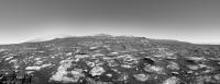
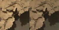
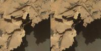
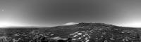
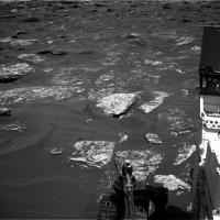
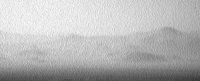
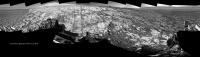
MSL 1726 with extended sky...
https://flic.kr/p/Veob9m
left
|
right
|
Posted by: fredk Jun 15 2017, 05:07 PM

It's not so much a new location as a new, extended view...
Posted by: PaulH51 Jun 15 2017, 11:26 PM
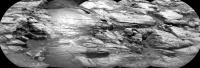
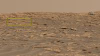
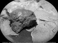
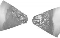
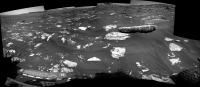
EDITED Having no luck with the 1727 end-of-drive NavCams using MS ICE... So here is a roughly assembled long distance (~100 meters) RMI Mosaic of a section the Vera Rubin Ridge, only four of the 5 frames have been released as 'enhanced data products'.
|
Posted by: Sean Jun 16 2017, 03:30 PM
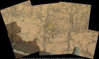
Here is 2km square of Vera Rubin Ridge & beyond made with best available HiRISE data & compressed to fit within Sketchfab constraints. 
https://skfb.ly/68Fxz
The 8k texture limit covers approx 2km sq.
Scaled for VR so you can start wandering from Sol 1727 location.
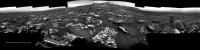
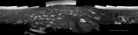
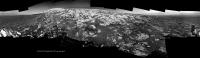
Posted by: jvandriel Jun 16 2017, 07:24 PM
The Navcam L view on Sol 1726.
Jan van Driel
|
|
Posted by: PaulH51 Jun 17 2017, 12:41 AM
1728 L-NavCam (MS ICE) after a drive to the East.
|
|
Posted by: PaulH51 Jun 17 2017, 11:00 AM
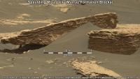
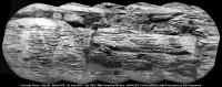
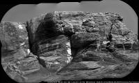
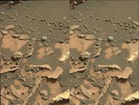
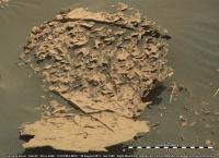
Cropped 1727 R-MastCam mosaic (2 frames in MS ICE, sharpened with 1 meter-long scale bar added), features what I believe to be https://mars.jpl.nasa.gov/msl/mission/mars-rover-curiosity-mission-updates/?mu=sol-1727-blog-little-bit-of-everything The sedimentary layers appear to be a little odd / puzzling for mudstone? Likely a valid explanation for these cross bedding like features (thin mineral filled fractures?) 
|
Posted by: Sean Jun 17 2017, 11:20 AM
Slightly ahead of schedule...here is the 2km tile beyond Vera Rubin Ridge using best available HiRISE data squished into Sketchfab & scaled for VR
|
https://skfb.ly/68HnC
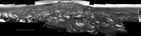
Posted by: jvandriel Jun 17 2017, 01:13 PM
The Navcam L view on Sol 1727.
Jan van Driel
|
|
Posted by: jvandriel Jun 17 2017, 02:25 PM
and the Navcam L view on Sol 1728.
Jan van Driel
|
|
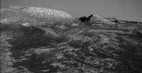
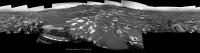
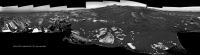
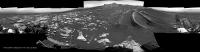
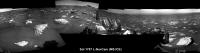
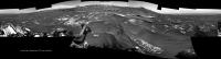
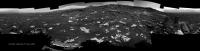
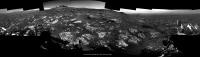
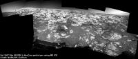
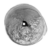
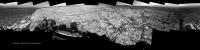
Posted by: Phil Stooke Jun 18 2017, 12:34 AM
This is Jan's panorama for sol 1726 - the one clearly showing the ridge - in circular form.
Phil
|
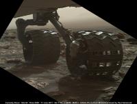
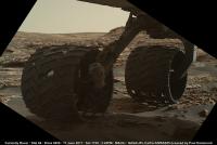
Posted by: PaulH51 Jun 18 2017, 09:02 AM
The first of wheel checkout MAHLI images acquired on 1729 are down. Lovely lighting and superb location.
|
|
Link to all images https://mars.jpl.nasa.gov/msl/multimedia/raw/?s=1729&camera=MAHLI
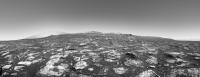
Posted by: Sean Jun 18 2017, 11:09 AM
Debayered & extended sky of Vera Rubin Ridge, Sol 1726
https://flic.kr/p/VQSsg1


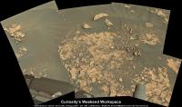
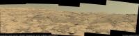
Posted by: neo56 Jun 18 2017, 05:31 PM
My take on this MC100 mosaic of Vera Rubin Ridge:
https://www.flickr.com/photos/thomasappere/34997268710/sizes/o/
Posted by: PaulH51 Jun 19 2017, 02:01 AM
Impressive work debayering / processing those MastCams
Posted by: atomoid Jun 19 2017, 09:46 PM
Thanks for the Sketchfabs Sean, I will say it enhances my quality of life flying around future MSL terrain like this!
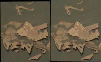
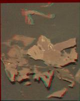
Here's an interssting composition from http://www.midnightplanets.com/web/MSL/image/01729/1729MH0001900010304846C00_DXXX.html, plus an obligartory http://www.midnightplanets.com/web/MSL/image/01728/1728MR0090250100803600E01_DXXX.html stereo crosseye. [edit: add balanced contrast crosseye and anaglyph]
|
|
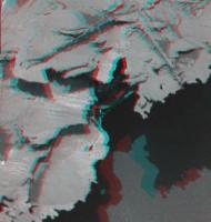
|
Posted by: elakdawalla Jun 19 2017, 10:53 PM
Every time I think the rock textures can't get weirder, Curiosity proves me wrong. Thanks for the 3D views.
And Sean, those Sketchfab VR things are awesome.
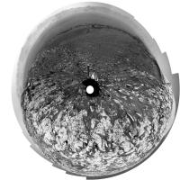
Posted by: jvandriel Jun 20 2017, 02:28 PM
The Navcam L view on Sol 1730
Jan van Driel
|
|
Posted by: Steve5304 Jun 21 2017, 12:21 PM
Here's an interssting composition from http://www.midnightplanets.com/web/MSL/image/01729/1729MH0001900010304846C00_DXXX.html, plus an obligartory http://www.midnightplanets.com/web/MSL/image/01728/1728MR0090250100803600E01_DXXX.html stereo crosseye.
|
|
That is interesting...I bet that is so brittle it would shatter like glass at if you dropped a pin. ...looks like Plaster at a right angle on potato chip ledge. I guess the low gravity atmosphere allows brittle and unsound structures to last longer than here on earth. Reminds me of when people mix copper and caste pipes a process begins called electrolysis which destroy both and you get pits, waves and right angles just like that rock. Interesting
Posted by: Sean Jun 21 2017, 01:00 PM
I have updated the Vera Rubin Sketchfab model to color...
https://skfb.ly/68Fxz
https://sketchfab.com/virtual-reality
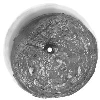
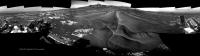
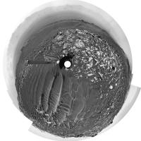
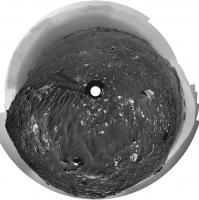
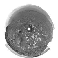
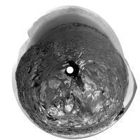
Posted by: Phil Stooke Jun 22 2017, 05:06 AM
This is a circular version of Jan's 1730 panorama. Many of the blocks are large enough to show up clearly in HiRISE images.
Phil
|
Posted by: Sean Jun 22 2017, 12:08 PM
MSL 1732...
https://flic.kr/p/VYhprJ
Maybe our path onto Vera Rubin Ridge is just left of center?... looks inviting!
Detail...
https://flic.kr/p/VYhpw3
https://flic.kr/p/VQh9qp
|
|
Posted by: Art Martin Jun 22 2017, 06:09 PM
A few questions to those in the know.
I saw today that a solar conjunction is coming up soon. What is the exact timing of that and do we plan on being atop Vera Rubin Ridge throughout it?
Secondly, because we've been climbing up this hill, the giant mesas at the base of Mt. Sharp have been hidden from view. I would imagine that the view from atop Vera Rubin Ridge will once again expose that dramatic geography and that they'll be considerably closer than when they disappeared. The photographs should be stunning. Am I right in my assumption?
Third, are there any upcoming sections of the trek ahead that appear particularly perilous with real questions as to whether the rover can navigate over the rugged and steep terrain especially with the degraded wheels?
Lastly, I've seen a number of daily updates that talk about doing further drill diagnosis but no indications at all about the outlook on being able to use this tool. Any insight on this?
Posted by: Holder of the Two Leashes Jun 22 2017, 06:57 PM
In regards to the drill, Emily Lakdawalla posted on the Planetary Society's blog last week:
http://www.planetary.org/blogs/emily-lakdawalla/2017/0613-curiosity-update-sols-1675-1725.html
They're shifting now from trying electronic solutions to the balky drill feed (like adjusting voltages, using one or the other or both brake coils) to mechanical solutions (experimenting with the orientation of the drill and with the use of vibration and percussion at different levels). And because it's been so long since the last successful drill attempt, on sol 1495 at Sebina, the project is beginning to expend some effort to explore some "less standard uses of the drill" that would bypass the use of the drill feed altogether for sampling activity. Let's all hope it doesn't come to that, but I'm glad they're preparing for the possibility that the drill feed mechanism might be unrecoverable.
In regards to the current situation facing the wheels, and the blocky terrain ...
Posted by: jvandriel Jun 22 2017, 07:52 PM
The Navcam L view on Sol 1732-1733.
Jan van Driel

|
Posted by: Sean Jun 23 2017, 12:11 AM
A simulated Curiosity ( scaled by HiRISE ) climbs Vera Rubin Ridge ( Sol 1732 )
https://flic.kr/p/UPeggR
Detail...
https://flic.kr/p/UPeg84

|
Posted by: PaulH51 Jun 23 2017, 02:56 AM
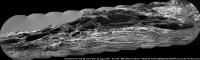
Quick and Dirty 10x2 RMI telephoto mosaic featuring a small section of 'Northern Neck' targeted on sol 1734. One of the frames (lower center) was not available as an enhanced data product when I assembled the mosaic. I've patched it as well as possible within the limitations of MS ICE and my basic skills. Hoping for a better version to be posted here
EDIT: I've identified the target area on a crop from Sean's CG mosaic

|
|
Mods please feel free to delete as better versions are posted
PS Great work Sean, love the CG Curi on the Ridge
Posted by: djellison Jun 23 2017, 06:14 AM
Jan van Driel
|
|
Yeahhhh....my bad on cutting that tiny piece off Mt Sharp with the upper tier. Couldn't convince myself I could still get all of VRR if I nudged it any more left. Fingers crossed I can try again on Monday.
Posted by: jvandriel Jun 23 2017, 01:25 PM
The Navcam L view on Sol 1734
Jan van Driel
|
|
Posted by: neo56 Jun 23 2017, 07:52 PM
My take on the MC34 mosaic of sol 1732:
https://www.flickr.com/photos/thomasappere/35490333925/sizes/k/
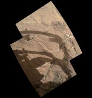
Posted by: PaulH51 Jun 24 2017, 02:18 AM
Sol 1734: 2 frame R-MastCam mosaic, part of a multi-spectral session. Provides detailed Stratigraphy / better context for the 10x2 telephoto ChemCam-RMI mosaic of Northern Neck on the Vera Rubin Ridge that I posted yesterday, processed in MS ICE.

|
Posted by: PaulH51 Jun 25 2017, 06:25 AM
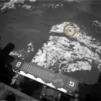
A simple 2 frame ChemCam-RMI mosaic from sol 1736, of what I believe could be the target referred to as 'https://mars.jpl.nasa.gov/msl/mission/mars-rover-curiosity-mission-updates/?mu=sol-1736-1739-a-roving-astronomer' in the latest mission update ('a block of the Murray formation that may have been tilted on its side'). Roughly assembled in MS ICE without further image processing. Also added a L-NavCam frame from 1734 which I believe contains the target block. I used AlgorimancerPG to establish the scales on the NavCam, this was then transposed onto the RMI. Once we have the context R-MastCam frame, I hope to be able to check the scale on the RMI. In the meantime, maybe we are seeing some more concretions, similar to those observed on Sol 1718? Refer to Atomoid's http://www.unmannedspaceflight.com/index.php?s=&showtopic=8298&view=findpost&p=236125 and subsequent replies
|

|
Posted by: djellison Jun 26 2017, 04:48 PM
Trying an upper tier again in Sol 1739 plan......fingers crossed I get all the things this time.
Posted by: PaulH51 Jun 27 2017, 01:13 AM
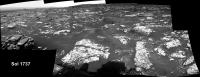
Sol 1737 partial R-NavCam pan after the drive East (MS ICE)
|
Posted by: PaulH51 Jun 27 2017, 06:15 AM
Sol 1737 RMI mosaic (3 frames assembled in MS ICE)
|
Posted by: PaulH51 Jun 28 2017, 01:57 AM
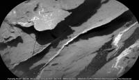
RMI mosaic from 2 frames acquired on sol 1739 (MS ICE, sharpened). Thoughts on what this may be?
|
Posted by: nprev Jun 28 2017, 03:25 AM
Kinda shiny, kinda dark, so my guess would be a little meteorite.
Posted by: Phil Stooke Jun 28 2017, 04:30 AM
Yes, could be!
Phil
Posted by: fredk Jun 28 2017, 04:50 AM
If anyone's up for a June Easter egg hunt, I think it's in this frame...
http://mars.jpl.nasa.gov/msl-raw-images/proj/msl/redops/ods/surface/sol/01737/opgs/edr/ncam/NRB_551700076EDR_F0641194NCAM00375M_.JPG
Posted by: PaulH51 Jun 28 2017, 07:17 AM
If this is the target, then it's probably ~40mm wide, should be able to get a better handle on the size once we have the R-MastCam context image that they often acquire with ChemCam images.
|
Posted by: PaulH51 Jun 28 2017, 07:52 AM
Following on from my earlier http://www.unmannedspaceflight.com/index.php?s=&showtopic=8309&view=findpost&p=236331, we now have the R-MastCam context image (processed) Here's the https://mars.jpl.nasa.gov/msl-raw-images/msss/01736/mcam/1736MR0090670000803720E01_DXXX.jpg to the raw image
|
Posted by: jvandriel Jun 28 2017, 08:31 AM
The Navcam L view on Sol 1737.
Jan van Driel
|
|
Posted by: PaulH51 Jun 28 2017, 01:06 PM
Partial L-NavCam 1739 (including what we have of the top tier Mods feel free to delete as the full pan is posted

|
Posted by: Sean Jun 28 2017, 02:51 PM
Extended sky from 1739...
https://flic.kr/p/UWDjsb
|
Posted by: djellison Jun 28 2017, 05:11 PM
There's a few more frames down - it should now be a complete 360 with no trimmed horizon anywhere
Posted by: jvandriel Jun 28 2017, 07:12 PM
The Navcam L view on Sol 1739.
Jan van Driel
|
Posted by: Steve5304 Jun 28 2017, 08:22 PM
http://mars.jpl.nasa.gov/msl-raw-images/proj/msl/redops/ods/surface/sol/01737/opgs/edr/ncam/NRB_551700076EDR_F0641194NCAM00375M_.JPG
The Slab appears to have shifted to the right?? Compared to prevouis sol the rover was nowhere near it. Cool. What did that
Posted by: serpens Jun 28 2017, 11:15 PM
There seems to be minor subsidence at the edge of the slab but no movement of the slab itself. This is a reasonably common phenomenon observed by MER and MSL and could have something to do with rover proximity.
Posted by: Phil Stooke Jun 28 2017, 11:48 PM
Jan's last two panoramas in circular form to show the local area in map form. Soon we will be seeing a broader view of the ridge and the slope we will climb.
Phil
1737:
|
1739:
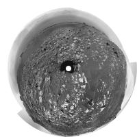
|
Posted by: PaulH51 Jun 29 2017, 06:10 AM
Not as polished as some of the nickel-iron meteorites spotted earlier by MSL! Not sure if LIBS was used on this target? Presented here in its Sol 1739 R-MastCam context image to support the RMI image https://mars.jpl.nasa.gov/msl-raw-images/proj/msl/redops/ods/surface/sol/01739/soas/rdr/ccam/CR0_551873426PRC_F0641194CCAM02739L1.PNG
Interestingly (or not) it failed to get a mention in the latest mission update https://mars.jpl.nasa.gov/msl/mission/mars-rover-curiosity-mission-updates/?mu=sols-1741-1743-cat-sized-island
|
(raw image)
Posted by: Sean Jun 29 2017, 01:37 PM
MSl 1739 360 NR extended sky
https://flic.kr/p/V2ecMz
cropped
https://flic.kr/p/WfGu2F
( I should have extended the exposure glare to the sun! Next time... )
resized, compressed & attached
|
Posted by: tolis Jun 29 2017, 02:56 PM
Interestingly (or not) it failed to get a mention in the latest mission update https://mars.jpl.nasa.gov/msl/mission/mars-rover-curiosity-mission-updates/?mu=sols-1741-1743-cat-sized-island
|
|
(raw image)
do those dark-coloured bits on the right of the meteorite look like fragments? I haven't seen that before.
Posted by: atomoid Jun 29 2017, 10:06 PM
i wasn't thinking meteorite itself, only basaltic bedrock fragments induced by an impact, but LIBS should reveal, and there do appear to be the usual pattern of LIBS hits most visible in the shadowed portion at right http://www.midnightplanets.com/web/MSL/image/01739/CR0_551873426PRC_F0641194CCAM02739L1.html.. The https://mars.jpl.nasa.gov/msl/mission/mars-rover-curiosity-mission-updates/?mu=sol-1739-1740-more-touch-and-go-on-the-way-to-vera-rubin-ridge mentions "..We have ChemCam LIBS observations of targets named "Hamilton Pond," "Whalesback," and Rice Point."
Posted by: PaulH51 Jun 30 2017, 03:14 AM
Good eyes
Here is a quickly assembled animated GIF:
Posted by: PaulH51 Jun 30 2017, 09:44 AM
Sol 1741 L-NavCam partial pan after another drive (~ENE). Very roughly assembled using MS ICE: mods please feel free to delete after full size, or better version is posted.

|
Posted by: Ant103 Jun 30 2017, 03:25 PM
Very nice Sean
Here is my take on this beautiful panoramic :
http://www.db-prods.net/blog/2017/06/30/heading-vera-rubbin-ridge-a-sol-1739-postcard/
Posted by: Sean Jun 30 2017, 03:49 PM
Beautiful work Damia! I much prefer yours.
Posted by: Phil Stooke Jun 30 2017, 08:56 PM
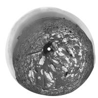
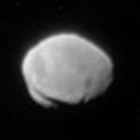
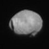
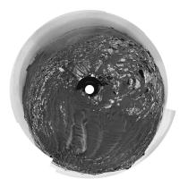
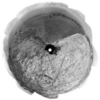
This is Phobos as seen on sol 1730, a 4x enlargement with six images merged and individually processed. Stickney on the left.
Phil
|
Posted by: atomoid Jul 1 2017, 01:03 AM
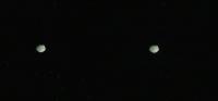
really http://www.midnightplanets.com/web/MSL/image/01730/1730MR0090330030803640E01_DXXX.html they managed to get as it presumably came out of the penumbra, shown here in cross-eye because (despite the orbital motion) it's so much closer than the stars!
|
Posted by: PaulH51 Jul 1 2017, 04:33 AM
Sol 1741 RMI mosaic featuring the stratigraphy of another section of the Vera Rubin Ridge, not sure about scale, but I estimate the distance to be around 80-85 meters South of the rover (distance depends on its position on the slope). There was another RMI frame, sadly that had data drop-out, not sure if it belonged to the same set or a different section. Assembled in MS ICE and rotated, not sharpened or processed other than stitching in MS ICE.
|
Posted by: Hungry4info Jul 1 2017, 05:40 AM
Has there been any consideration of looking at Phobos through ChemCam? It's certainly something I would do if I were on Mars with a telescope.
Posted by: PaulH51 Jul 1 2017, 09:30 AM
A simple animation (GIF) of Phobos imaged during the early hours of sol 1730 (13 frames) the timing of each frame varies towards the end of the animation, maybe more frames are in the pipeline? The mission update tells us this was done to help measure the dust in the upper atmosphere... 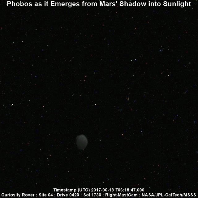
To run the animation full size https://www.flickr.com/photos/105796482@N04/35257001640/sizes/o/
Posted by: Art Martin Jul 1 2017, 04:22 PM
Time for a new Mars anaglyph pan.
https://flic.kr/p/WfVktohttps://flic.kr/p/WfVkto
Posted by: jvandriel Jul 2 2017, 01:37 PM
The Navcam L view on Sol 1741.
Jan van Driel
|
Posted by: Phil Stooke Jul 2 2017, 06:20 PM
"Has there been any consideration of looking at Phobos through ChemCam? It's certainly something I would do if I were on Mars with a telescope."
Yes - but it's tricky. See this discussion:
http://www.unmannedspaceflight.com/index.php?showtopic=7730&st=285
Phil
Posted by: PaulH51 Jul 3 2017, 01:34 PM
Note: Those RMIs are from sol 741 (in case anyone is chasing down the PDS images)
Also note: That discussion took place ~1000 sols ago. Time flies for sure... Seems like a couple of months ago
Posted by: PaulH51 Jul 3 2017, 10:38 PM
1736 R-MastCam animated GIF (unprocessed raw files) with a sharper view of Stickney
|
Link to full size version on Imgur: http://imgur.com/a/fWsfV
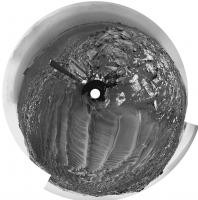
Posted by: Phil Stooke Jul 3 2017, 11:39 PM
Nice! Here is an enlarged view, north at the top, a merge of five frames.
Phil
|
Posted by: Phil Stooke Jul 4 2017, 03:07 AM
Jan's sol 1741 panorama in circular form. Compared with the last one (previous page) we are much closer to the prominent blocks.
Phil
|
Posted by: Sean Jul 4 2017, 08:15 AM
I refreshed my workflow for these simulated clips of Curiosity driving around HiRISE models mapped to mosaics...click thru for a video of Curi climbing Vera on Sol 1732.
https://flic.kr/p/Vb1S6a
I'll take a look at the speed & suspension on the next one.
Posted by: PaulH51 Jul 4 2017, 01:10 PM
A 4th of July Special from Curiosity, in the form of a long range 10 frame RMI mosaic featuring another section of the Vera Rubin Ridge. Rather nice for MS ICE, I'm hoping that rash statement will inspire others to have a go at this one There is another 10 frame mosaic, but that will have to await my morrow.
Happy 4th to all that are celebrating the original Brexit V1 (1776 version)
|
Posted by: scalbers Jul 4 2017, 03:21 PM
Interesting to see this Sean. Is Curiosity in your video climbing at a point SW of Northern Neck? I wonder what the slope is there (and traversing later beyond the field of view). My guess would be that a gentler climb is possible in the relative trough just to the east of Northern Neck, though still west of the notional route mentioned recently by Fernando. This would be after circling around the east side of the drifts.
I suppose one could look at a slope map and figure out what path across the ridge has the lowest value of maximum up/down slope. This is what I had roughly done earlier by eye with your 3D interactive view.
Posted by: Sean Jul 4 2017, 04:05 PM
Yes Steve, you can see this on the model also...
https://skfb.ly/68Fxz
The planned route does offer what appears to be the best entry point to the Ridge, with the possible exit not far away to the south east.
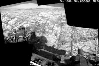
Posted by: PaulH51 Jul 5 2017, 08:45 AM
Drive to site 64/1890 on sol 1746, duration >50 minutes (MS-ICE with L-NavCam)
Not many frames yet, but this may help to identify the location

|
Edit: Several additional frames are down now (including a few of the top tier), but MS ICE can't cope with the sandy ripples (great pity).
Midnight Planets https://twitter.com/MidnightLoader/status/882556564640587777the drive as ~22 meters East (100º) on Sol 1746. The direct path looks like an obstacle course, so they may head a little further East before going south? Whichever way they go, looks like there are no shortage of ground targets between the drives to the entry ramp
Posted by: PaulH51 Jul 6 2017, 10:58 AM
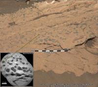
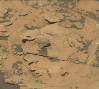
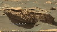
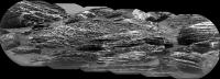
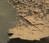
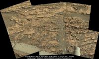
Sol 1745 R-MastCam (cropped mosaic) features one of several eroded blocks imaged by the mast camera. I've added a scale bar (50cm) below the block using AlgorimancerPG, the image has been sharpened a little.
There is a rather nice http://mars.jpl.nasa.gov/msl-raw-images/msss/01745/mcam/1745MR0091200160803864C00_DXXX.jpg from the same sol, featuring an upper section of the Vera Rubin ridge, but it is bayer encoded and I can't do it justice after decoding (too many compression artifacts).
|
All 1745 MastCam images https://mars.jpl.nasa.gov/msl/multimedia/raw/?s=1745&camera=MAST_
Posted by: PaulH51 Jul 6 2017, 11:17 AM
Sol 1746 L-MastCam 'Drive Direction' mosaic, MS ICE with unprocessed raw images

|
Raw images http://www.midnightplanets.com/web/MSL/sol/01746.html
Posted by: Sean Jul 6 2017, 11:46 PM
Here is another HiRISE enabled animation using Sol 1732 RGB mosaic mapped to Navcam composition. RGB gaps filled with data from Sols 1601, 1730, 1734 & extended sky
Click thru for the 4k version...
https://flic.kr/p/VdbGLs
Click thru for the 2k version ( zoom cut in this sequence )...
https://flic.kr/p/WqX3Nf
https://youtu.be/4yEMWT6t-6k
https://youtu.be/5CF9Fim8HwY
This one has music & retimed to suit...
https://flic.kr/p/WvETcn
Posted by: neo56 Jul 7 2017, 09:16 AM
Paul, I processed the bayer encoded MC100 pics of sol 1745
 . Here is the mosaic:
https://www.flickr.com/photos/thomasappere/35773223335/sizes/o/
I also stitched the two RMI mosaics and placed them into context:
https://www.flickr.com/photos/thomasappere/34963425613/sizes/k/
Posted by: PaulH51 Jul 8 2017, 01:58 AM
. Here is the mosaic:Thomas: Excellent de-bayering / treatment of the compression artifacts. Your panchromatic sharpening makes those RMI's come alive, great to see your work here once again
Paul
Posted by: PaulH51 Jul 8 2017, 10:40 AM
Sol 1748 : L-MastCam Workspace: Assembled in MS ICE, no additional processing, looks a little overexposed, but I've left the mosaic in its raw state (just stitched)
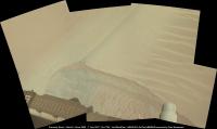
A 5-Sol plan has been issued https://mars.jpl.nasa.gov/msl/mission/mars-rover-curiosity-mission-updates/?mu=sol-1748-1752-kicking-up-some-sand 'Sol 1748-1752: Kicking Up Some Sand'
I've tried to assemble the available NavCam frames for 1748, but they wont behave in MS ICE, which is a pity as the scene is rather special with the large sandy ripples...
|
Posted by: jvandriel Jul 8 2017, 12:20 PM
The Navcam L view on Sol 1746.
Jan van Driel
|
Posted by: jvandriel Jul 8 2017, 02:00 PM
and the view on Sol 1747.
Jan van Driel
|
Posted by: Phil Stooke Jul 9 2017, 07:23 PM
Jan's last two panoramas in circular form.
Phil
Sol 1746:
|
Sol 1747:
|
Posted by: PaulH51 Jul 10 2017, 02:52 AM
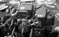
1749 MAHLI of the wheel scuff across the ripple, shows some interesting grain size distribution. Unprocessed other than adding the scale bar. Enhancing the colours shows some nice grain colour variations including one tiny and much redder grain than we are used to seeing, but I guess that may be a JPG compression artifact.
The scale bar is only applicable to items in sharp focus. Thumbnails suggest a focus stacked version was planned.

|
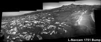
Posted by: PaulH51 Jul 10 2017, 10:42 AM
L-NavCam partial pan after a bump on 1751 roughly assembled in MS ICE
|
Posted by: PaulH51 Jul 11 2017, 01:22 PM
I've seen the dates for the solar conjunction moratorium on commanding Opportunity (July 22 to Aug. 1, 2017) https://mars.nasa.gov/allaboutmars/nightsky/solar-conjunction/
Anyone here aware of the dates for MSL? Maybe I missed it
Posted by: djellison Jul 11 2017, 01:44 PM
Last tactical shift is this Friday but I think the last drive will be Wednesday to allow us time to recover if something goes wrong with that drive, before conjunction starts.. First tactical shift afterwards is Monday Aug 7th, planning Sol 1780
I believe were expecting a BIG dump from MRO on the Friday before we start planning again.
Posted by: RoverDriver Jul 11 2017, 02:22 PM
Anyone here aware of the dates for MSL? Maybe I missed it
Doug is right regarding MSL, but JPL is wrong with the dates for Oppy. Today is the last tactical shift for which we have a downlink before conjunction and July 18 is the last tactical shift with uplink before conjunction. We resume tactical on Aug 2.
Paolo
Posted by: Phil Stooke Jul 11 2017, 06:52 PM
Sol 1752. These are Hazcams roughly reprojected to help me find the block we are looking at after the drive.
Phil
|
Posted by: PaulH51 Jul 12 2017, 02:01 AM
Thanks guys for the info on the solar conjunction, but I know I'll have withdrawal symptoms during the image drought.
EDIT
Here's an updated version of a long-distance RMI mosaic featuring a section of the Vera Rubin Ridge. Now with 10 overlapping frames assembled in MS-ICE
|
Posted by: Sean Jul 12 2017, 12:55 PM
Is the number of 'Drivecam' images a rough indicator of how far Curi has driven?
From 1752 measure of 10m it looks like 1753 is around 20m ( before metadata )
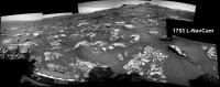
Posted by: PaulH51 Jul 12 2017, 01:11 PM
That's an interesting theory Sean:) We'll see later... Meanwhile...
Roughly assembled partial 1753 L-NavCam in MS ICE
|
Posted by: djellison Jul 12 2017, 03:39 PM
From 1752 measure of 10m it looks like 1753 is around 20m ( before metadata )
You mean the images with a SeqID of TRAV00NNN in them? They could sort of be used as an analogue for drive distance - but the step between them can vary
Posted by: Sean Jul 12 2017, 05:15 PM
Thanks Doug.
Posted by: jvandriel Jul 12 2017, 08:30 PM
The Navcam L view on Sol 1751.
Jan van Driel
|
Posted by: Phil Stooke Jul 12 2017, 09:01 PM
Thanks. Jan. Here it is in circular form.
Phil
|
Posted by: jvandriel Jul 13 2017, 08:35 PM
The Navcam L view on Sol 1752.
Jan van Driel

|
Posted by: PaulH51 Jul 14 2017, 07:49 AM
Formal MSL conjunction dates:
Mission Update: Sol 1755: Getting Ready to Disappear Behind the Sun, by Roger Wiens, dated 13 July 2017 https://mars.jpl.nasa.gov/msl/mission/mars-rover-curiosity-mission-updates/?mu=sol-1755-getting-ready-to-disappear-behind-the-sun
Posted by: jvandriel Jul 14 2017, 12:30 PM
The Navcam L view on Sol 1753.
Jan van Driel
|
Posted by: jvandriel Jul 14 2017, 03:01 PM
and the Navcam L view on Sol 1754.
Jan van Driel
|
Posted by: PaulH51 Jul 14 2017, 10:51 PM
In case you missed the public talk 'Five Years of Curiosity on Mars' aired on July 13, 2017, here is the YouTube https://youtu.be/zqhK8dA7iO8?t=524
Posted by: serpens Jul 15 2017, 02:20 AM
I had missed that Paul. Thank you for the heads up. It was an outstanding summary of the findings to date and indeed explained the conflict between empiracle evidence and the models of the early solar system in plain English. More, it was most entertaining and I will be watching it a few times to fill in the time before we can talk to the rovers again.
Posted by: jvandriel Jul 15 2017, 07:43 PM
The last 3 images are down and here is the complete Sol 1748 Navcam L panorama.
Jan van Driel

|
Posted by: neo56 Jul 16 2017, 01:13 PM
Here is sol 1751 NavCam R panorama patched with pics of Mt Sharp taken on sol 1749, with an extended sky.
https://www.flickr.com/photos/thomasappere/35147925243/sizes/o/
Posted by: neo56 Jul 16 2017, 08:31 PM
MC34 panorama taken on sol 1756 at 13h32 local time:
https://www.flickr.com/photos/thomasappere/35833940111/sizes/o/
This panorama offers a new perspective on the top right outcrop already imaged on sol 1745 by MC100:
https://www.flickr.com/photos/thomasappere/35773223335/sizes/l
Posted by: serpens Jul 17 2017, 01:35 AM
It is worthy of note that during question time following the public talk on Curiosity, James Erickson was extremely upbeat over the future use of the drill and was extremely confident that a fix to the current problem was imminent. This is good news indeed.
Posted by: PaulH51 Jul 18 2017, 01:12 AM
Possible evidence in support of that confidence in this L-MastCam from sol 1757 where we can see they have extended the drill feed mechanism. Emily Lakdawalla referred to "less standard uses of the drill" in her last Curiosity Blog http://www.planetary.org/blogs/emily-lakdawalla/2017/0613-curiosity-update-sols-1675-1725.html
Maybe leaving the drill extended to drill a hole without the supports, and then obtaining the powdered rock sample with the https://mars.nasa.gov/news/2017/curiosity-mars-rover-begins-study-of-ridge-destination... difficult on a windy day, but it could keep SAM working

|
Posted by: serpens Jul 19 2017, 12:08 AM
Using the drill even in rotary mode without using the contact sensors and stabilisers would seem to be pretty risky. The percussive action of the drill was designed to pulverise the rock to powder and the vibration, combined with the auguring action of the drill raised the powder to the collection chamber without clogging. I wonder whether rotary action alone would grind rock finely enough to transfer it up the drill shaft to the collection chamber? Given the small size of a drill hole and spoil it is hard to see how the scoop could secure a sample and even then there would be a high probability of cross contamination from surface dust. Still, the work arounds that have been achieved on MER and MSL have been impressive to say the least and it will be fascinating to see what magic they use with the drill.
Posted by: djellison Jul 19 2017, 01:31 AM
Percussive drilling was pretty much off the table before the current drill issues arose - so that's not really a consideration. Rotary only drilling was planned when the problem with the feed first arose (and that was my 7th training shift on ECam - Sol 1536
I've not seen specifics of the drill testing they've been doing with the test-bed - but I've heard good things about their results. The fact that we're now 7.5 months after the drill anomaly occurred and only just beginning to see work arounds being discussed for use on Mars should give you some idea of how much care, diligence and attention is being paid to this. Depending on your value of 'risky' - I wouldn't say they were planning anything that puts the vehicle or other functional instruments at 'risk'.
(see this old press release - https://mars.jpl.nasa.gov/news/curiosity-rover-team-examining-new-drill-hiatus&s=2 )
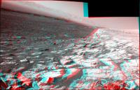
Posted by: fredk Jul 21 2017, 03:33 PM
Clouds drifting by on 1758, unstretched:

|
Posted by: fredk Jul 21 2017, 03:36 PM
Another navcam sequence on the same sol which needed some stretching (after subtraction of the mean):

|
Posted by: serpens Jul 29 2017, 12:35 AM
Looking at relative elevations, would I be correct in thinking that the erosion resistant, hematite cemented Vera Rubin Ridge cap would have been part of the horizon between the Murray Formation and the sulphate unit?
Posted by: Gerald Jul 29 2017, 11:34 PM
Do you suggest, that the clay unit is part of the Murray Formation? Then, after the clay unit, there should be another fragment of Vera Rubin Ridge type, before the sulfate unit begins.
Posted by: serpens Jul 30 2017, 12:37 AM
If Mr Steno's principle of original continuity holds true then the (pre-erosion) upper level of what became the hematite ridge would have been a continuous, pretty much horizontal sheet that was then covered by the sulphate unit. The clay is in an eroded trough and since there does not seem any indication of the layer on Curiosity's side of the ridge the clay may have formed as a late, localised event during the erosion of Mount Sharp, possibly connected with the fan. If the ridge upper level was part of the horizon between Murray formation and the sulphate unit then the hematite would have probably formed within reasonably unconsolidated, layered sediment which makes the concept of a linear confined aquifer near the surface, oxygenated via the vadose zone less likely than a surface stream. The transition to a more acid environment represented by the sulphates does raise a few possibilities with respect to the ferric deposition process.
Posted by: Gerald Jul 31 2017, 12:13 AM
Wouldn't the finely laminated structure of Vera Rubin Ridge, as far as we can see thus far, suggest, that we are still in a lacustrine environment, but closer to the surface below an oxygen-bearing atmosphere?
The sufate layer may have formed after erosion of lithified older layers.
-- I'm not perfectly up to date with the current state of discussion about the contact to the sulfate layer, but I'd presume, there are still various options.
Posted by: Phil Stooke Jul 31 2017, 04:06 AM
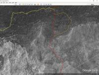
I don't think lacustrine, there is lots of cross-bedding in the ridge (see the ridge images at the top of this page), so aeolian accumulation followed by episodes of wetting and lithification would be my guess.
Phil
Posted by: serpens Jul 31 2017, 04:39 AM
To be fair we need to get up close to determine whether there is cross bedding indicative of surface water flow or as Phil posits, purely aeolian with later diagenisis. But the presence of the hematite ridge is fascinating.
The thing is that iron oxides have a large number of polymorphs and (for me anyway) confusing phase transformations. However the basic route to hematite requires a ferrous solution (and ferric in solution in low <5 pH waters) and oxidation. We do not know the makeup or partial pressures of the Martian atmosphere at the time the ridge formed but it would be safe to assume that the capacity for oxygenation was very limited. The amount of oxygen required to transition ferrous to ferric and hence deposition as iron hydroxide 2Fe(OH)3 reduces dramatically as pH falls which draws attention to the sulphate unit. The process from the iron hydroxide via goethite to hematite or even direct to hematite is more intuitive with standard notation where 2Fe(OH)3 = Fe2O3·3H2O or Ferric Oxide Trihydrate. The transition from Goethite 2FeO(OH) = Fe2O3·H2O can occur at quite low temperatures (40 celcius) which could have been supplied via burial.
Posted by: HSchirmer Jul 31 2017, 03:52 PM
so aeolian accumulation followed by episodes of wetting and lithification would be my guess.
Is there any geomorphology on earth where we have a good understanding of deposition under permafrost conditions,
something with aeolian dust, snowdrifts and sand?
Posted by: serpens Aug 2 2017, 04:41 AM
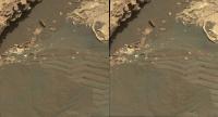
Just as a follow up to Phil's observation. Probably wishful thinking but this could possibly be scour which would imply running surface water.
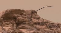
|
Posted by: Art Martin Aug 3 2017, 03:27 PM
Must be passing out of solar conjunction. Seeing some pictures coming from the rover over the last few hours.
Posted by: PaulH51 Aug 5 2017, 08:31 AM
Good to see those images
Normal operations expected to resume on the 7th.Question: Did JPL ever release the names of the buttes / mesas's in the Murray Buttes? I recall they referred to one in a news release, it had a number of I recall correctly. I'm toying with the idea of assembling some of the mosaics using PDS images, be much cleaner if I could name them with official names. TIA
Posted by: Phil Stooke Aug 5 2017, 03:24 PM
They didn't get names, they got numbers. M1, M2 and so on. I updated my map of the Buttes when PDS gave the target names, so i will post it for you in the route map thread.
Phil
Posted by: PaulH51 Aug 5 2017, 08:19 PM
Phil
Perfect, many thanks Phil
Posted by: PaulH51 Aug 9 2017, 12:22 AM
A few recent engineering camera images are down... I assembled this little GIF from FLB frames from 1772 and 1779, apart from the small changes in the shadows, there is no obvious sand movement, maybe the seasonal winds are abating, or we are sheltered by the ridge? Looking forward to normal service resuming ASAP

|
Posted by: PaulH51 Aug 10 2017, 09:46 AM
Nice drive on 1781 of ~61 minutes, rough L-NavCam in MS ICE, may assist in narrowing down the location until we get the rest of the frames

|
Edit: Midnight Planets reports the drive as ~32.0m (160º) SSE. https://twitter.com/MidnightLoader/status/895587283637850112
Edit 2: If I have my bearings right, that was a pretty impressive climb
Posted by: jvandriel Aug 10 2017, 09:14 PM
The Navcam L view on Sol 1781.
Jan van Driel

|
Posted by: Phil Stooke Aug 10 2017, 10:15 PM
Thanks, Paul and Jan. It's good to see new rocks under our wheels. This is Jan's panorama in circular form, which gave me a good location for the route map.
Phil

|
Posted by: PaulH51 Aug 11 2017, 06:31 AM
Sol 1782 drive, looks like about 30 minutes
Roughly assembled L-NavCam partial pan using MS ICE and the 13 available frames, including those lovely top tier images... thanks JPL
BTW: Is it me, or have they changed the exposure times on the recent post-drive images, seem to have a lot less issues with under/over exposed terrain Makes stitching in MS ICE so much easier.

|
EDIT: Midnight Planets https://twitter.com/MidnightLoader/status/895959177536864258Curiosity moved approximately 12.2m SE (130º) on Sol 1782
Posted by: PaulH51 Aug 11 2017, 06:48 AM
Sol 1780: The drill feed mechanism looks to be fully extended in this raw Left Mastcam frame
And as luck would have it, we have Mt Sharp as a fitting backdrop...
Part of the https://mars.jpl.nasa.gov/msl/mission/mars-rover-curiosity-mission-updates/?mu=sol-1780-five-earth-years-on-mars into the drill issues.
EDIT: Added a roughly aligned animated GIF, using a pair of L-MastCams before and after the Solar Conjunction

|

|
Posted by: jvandriel Aug 12 2017, 02:58 PM
The Navcam L view on Sol 1782.
Jan van Driel

|
Posted by: Phil Stooke Aug 13 2017, 05:53 PM
Great, Jan - here is a circular projection of your panorama. We are moving around the slope and its big blocks, heading for the on-ramp to the ridge which is still southeast of here but not too far away.
Phil

|
Posted by: serpens Aug 14 2017, 04:07 AM
Thanks Phil, that really gives a good visual indication of how high we have climbed.
Posted by: PaulH51 Aug 14 2017, 09:43 AM
Roughly assembled L-NavCam from 1785 after a ~55 minute drive. EDIT MP reports it as ~30 meters East.

|
Posted by: atomoid Aug 15 2017, 12:29 AM
doh!!wrong..thread..cant..delete..reposting..here's something within scope from http://www.midnightplanets.com/web/MSL/image/01782/1782ML0092040000702029E01_DXXX.html

|
Posted by: PaulH51 Aug 15 2017, 01:25 PM
The best I could pull out of MS ICE. L-NavCam 1786. Midnight Planets reports the point to point drive as ~16.0m NE (39º)
|
Posted by: jvandriel Aug 15 2017, 02:19 PM
The Navcam L view on Sol 1785.
Jan van Driel
|
Posted by: jvandriel Aug 15 2017, 04:54 PM
and the view on Sol 1786.
Jan van Driel
|
Posted by: Phil Stooke Aug 15 2017, 06:37 PM
Thanks, Jan and Paul. This is Jan's panorama in circular form. The drive probably terminated as the wheels were negotiating a rocky mound here. It's actually very surprising that this doesn't happen more often!
Phil
|
Posted by: RoverDriver Aug 15 2017, 07:13 PM
It's actually very surprising that this doesn't happen more often!
We try to avoid these things. Whenever the surface topography is this extreme, the reconstructed surface has "holes" due to occlusions which prevents us from accurately simulating attitude and suspension values during a drive. Sometimes we have no choice, we have to drive through holes (holy drives?) and we spend considerable amount of time to decide which holes to visit. End of drive positions are chosen also to maximize visibility and reduce occlusions in the intended drive direction.
Paolo
Posted by: PaulH51 Aug 16 2017, 10:10 AM
Paolo
Thanks for the insight Paolo, much appreciated
Looks like they captured the culprit in this sol 1787 mid-drive NavCam image looking back to where yestersols drive halted. Appears to be a loose block that was moved by the rover's wheels.
|
Posted by: PaulH51 Aug 16 2017, 10:35 AM
The roughly assembled L-NavCam partial pan using MS ICE that may help pinpoint the location until the full version is posted here. As usual, feel free to delete this post once full pan is posted.
|
Posted by: RoverDriver Aug 16 2017, 04:48 PM
Looks like they captured the culprit in this sol 1787 mid-drive NavCam image looking back to where yestersols drive halted. Appears to be a loose block that was moved by the rover's wheels.
...
What happened is that the newly developed traction control software interpreted the local topography as a "wheelie" (*) and tried to correct it but failed to do so. While the available torque is Bugatti-Veyron class (really!), it still cannot change Mars topography.
Paolo
(*) wheelies on Mars happen when either the mid or rear wheels are raised from the surface due to difference in traction. While driving forwards, if the rear wheel has more traction than the front, the mid wheel can be raised. Vice-versa, while driving backwards if the front wheels have more traction that the mid, the rear wheels can come up. Keeping all wheels on the surface increases overall traction and reduces stress on the wheels and rover planners.
Posted by: jvandriel Aug 16 2017, 07:24 PM
The Navcam L view on Sol 1787.
Jan van Driel

|
Posted by: jvandriel Aug 17 2017, 06:53 PM
The Navcam L view on Sol 1788.
Jan van Driel
|
Posted by: atomoid Aug 17 2017, 10:41 PM
here are a couple corsseye views of m34/m100 pairs on http://www.midnightplanets.com/web/MSL/image/01782/1782ML0092050010702034E01_DXXX.html and http://www.midnightplanets.com/web/MSL/image/01787/1787MR0092250010804100E01_DXXX.html
|
|
Posted by: PaulH51 Aug 20 2017, 12:03 PM
Partial RMI mosaic (sharpened) of VRR, acquired on sol 1790.
Sadly one of the images in the sequence had data drop out, so MS ICE could not be convinced to assemble all of the https://mars.jpl.nasa.gov/msl/multimedia/raw/?s=1790&camera=CHEMCAM_.
Even though incomplete, it gives us a fairly good look at the stratigraphy of this section of the ridge... If they resend the errant frame I'll try to assemble the complete mosaic.
|
Posted by: Phil Stooke Aug 21 2017, 06:11 PM
Jan's panorama for sol 1788 in circular form.
Phil
|
Posted by: jvandriel Aug 21 2017, 08:39 PM
The Navcam L view on Sol 1792.
Jan van Driel
|
Posted by: atomoid Aug 21 2017, 09:13 PM
some aolean art http://www.midnightplanets.com/web/MSL/image/01790/1790MR0092430020804129E01_DXXX.html
|
|
Posted by: Phil Stooke Aug 21 2017, 09:29 PM
This is Jan's panorama from sol 1792 in circular form. We were supposed to have a drive on sol 1792, but it didn't happen, so this is the same location as sol 1789.
Phil
|
Posted by: PaulH51 Aug 22 2017, 01:39 PM
Lower temperatures than https://mars.jpl.nasa.gov/msl/mission/mars-rover-curiosity-mission-updates/?mu=sol-1793-its-always-sunny-in-gale-crater! So the drive was rescheduled for 1793, but the actual drive may be a tad shorter than planned? http://www.midnightplanets.com/web/MSL/sol/01793.html
Posted by: jvandriel Aug 23 2017, 02:56 PM
The Navcam L view on Sol 1793.
Jan van Driel
|
Posted by: Phil Stooke Aug 23 2017, 05:27 PM
Jan's 1793 panorama in circular form.
Phil
|
Posted by: djellison Aug 23 2017, 06:13 PM
Jan van Driel
|
|
I had a little bit of freedom targetting the left-most image of the upper tier, so I managed to stretch it out beyond our normal 30 degree overlap to try and get all of Mt Sharp in. I think it actually gets the entire horizon without getting cut off anywhere
Posted by: PaulH51 Aug 24 2017, 12:04 AM
And a magnificent sight it is. Thanks for that
Here is a partial L-NavCam pan after the drive on 1794 reported by Phil earlier, assembled in MS ICE, it may assist in confirming the location until a full pan can be assembled. Now I've just got to find the reference for 'http://www.unmannedspaceflight.com/index.php?act=attach&type=post&id=41877'
|
Posted by: PaulH51 Aug 25 2017, 11:06 AM
Roughly assembled (MS ICE) 10 frame Sol 1795 ChemCam RMI Mosaic
The https://mars.nasa.gov/msl/mission/mars-rover-curiosity-mission-updates/?mu=sol-1795-skirting-around-vera-rubin-ridge for this sol made a reference to this activity: Acquire a long distance ChemCam RMI mosaic of a contact between bright and dark rocks in part of the ridge.
|
Raw images https://mars.jpl.nasa.gov/msl/multimedia/raw/?s=1795&camera=CHEMCAM_
Posted by: nogal Aug 25 2017, 05:43 PM
Curiosity has been zigzagging through an obstacle filled path. A few more stand between it and VRR's top, but hopefully it will reach it next week.
Every once in a while I speculate (for myself) about the upcoming path (and I'm wrong more often then not). This time I'll paste here two alternative routes that seem ok to me - weekend filler - and I'm happy to be proved wrong once again.
Fernando
|
Posted by: jvandriel Aug 25 2017, 06:19 PM
70 Mastcam R images, taken on Sol 1785, Debayerd and stitched.
Jan van Driel
|
|
Posted by: PaulH51 Aug 27 2017, 10:28 AM
Looking at Fernando's proposed path and the images of the more direct path I'd have to concur with his choice to save the wheels
Attached is the arm weekend workspace for 1796 L-MastCam (MS ICE - sharpened) I dont think JPL published the weekend mission update, but there has been plenty of contact and remote science so far and likely more will take place today (1798)
|
Posted by: jvandriel Aug 28 2017, 11:48 AM
The Navcam L view on Sol 1794.
Jan van Driel
|
Posted by: jvandriel Aug 28 2017, 03:18 PM
and the view on Sol 1795.
Jan van Driel
|
Posted by: jvandriel Aug 28 2017, 06:17 PM
The Navcam L view on Sol 1796.
Jan van Driel
|
Posted by: Phil Stooke Aug 28 2017, 07:01 PM
Thanks, Jan - I like the larger format you are giving us now. Here is the sol 1796 panorama in circular format.
Phil
|
Posted by: PaulH51 Aug 29 2017, 11:02 AM
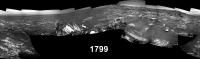
Quick and dirty pan using MS-ICE of the 1799 L-NavCams, feel free to delete when the proper version is posted
|
Posted by: PaulH51 Aug 29 2017, 11:11 AM
MAHLI 1798: One of 5 full sets of routine https://mars.jpl.nasa.gov/msl/multimedia/raw/?s=1798&camera=MAHLI (rotated, cropped and sharpened). I can't see any obvious new breaks in the grousers, which if confirmed is great news

|
Posted by: jvandriel Aug 29 2017, 06:39 PM
The Navcam L view on Sol 1799.
Jan van Driel

|
Posted by: Phil Stooke Aug 29 2017, 08:28 PM
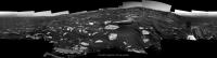
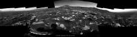
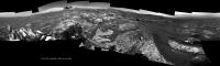
Something a little bit different. All eyes are on Vera Rubin Ridge, but if you turn around, our increased elevation gives the best view to date of the northern floor of Gale Crater.
This image is a CTX mosaic of northern Gale (top) and a vertically stretched full resolution Navcam mosaic looking north on sol 1799. It's only a rough mosaic, not properly controlled. But quite a few features can be seen including the Yellowknife Bay area at far right. This is a heads-up for the Mastcam mosaic taken a few sols ago - when we get that it will offer a really nice view of the crater floor, and many more features might be visible near the landing site.
Phil

|
Posted by: PaulH51 Aug 29 2017, 10:17 PM
Nice work Jan & Phil, looking forward to that MastCam mosaic looking back...
Here's the drive direction L-MastCam from sol 1799, raw in MS-ICE
|
|
Posted by: PaulH51 Aug 30 2017, 12:54 AM
Roughly assembled L-NavCam after the latest climb on sol 1800, it may help to establish a location until more frames come down.

|
Posted by: atomoid Aug 31 2017, 02:26 AM
trying to get some long-baseline stereo from sets of recent crater floor navcams (sol1793+1800, sol1793+1795).
..but rather of hard on the eyes the stereo breaks down, so my favorite view is a normal-baseline of the http://www.midnightplanets.com/web/MSL/image/01795/NRB_556856106EDR_F0651934NCAM07753M_.html composition of rockpile stepping-stones
|
|

|

|

|
Posted by: marswiggle Aug 31 2017, 03:10 AM
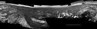
Another view to the north in anaglyph form using yet wider baseline - don't remember the corresponding navcams sols anymore but the right side image must be from sol 1793. This is a kind of follow-up to an earlier post from myself, tracing the emergence of faraway northern mountains over the rim of Gale. Currently two different peaks at different distances can be seen almost lined up at the center of this image. Please note that I have used 3x vertical stretch.
Can't wait to see how they will appear in the upcoming Mastcam images.

|
Posted by: PaulH51 Aug 31 2017, 08:42 AM
L-Mastcam 'drive direction' mosaic from 1800, quick and dirty in MS ICE, raw images (no processing)
|
|
Posted by: Phil Stooke Aug 31 2017, 06:47 PM
Marswiggle! That's great. I had not noticed those distant features. I must have missed your earlier post about them.
I compared sols 1400 and 1800:

|
This is what I think we are seeing:

|
(the grid has 30 km spacing)
Phil
Posted by: elakdawalla Aug 31 2017, 11:34 PM
This image is a CTX mosaic of northern Gale (top) and a vertically stretched full resolution Navcam mosaic looking north on sol 1799. It's only a rough mosaic, not properly controlled. But quite a few features can be seen including the Yellowknife Bay area at far right. This is a heads-up for the Mastcam mosaic taken a few sols ago - when we get that it will offer a really nice view of the crater floor, and many more features might be visible near the landing site.
Wow, that is going to be really awesome.
Posted by: marswiggle Aug 31 2017, 11:49 PM
Thank you Phil, I concur with your identification. Yeah, a 'follow-up' to my observation about one and a half years ago, that was based on Mastcam images sols 1270 & 1302. I'm not sure in which thread it is now. http://www.unmannedspaceflight.com/index.php?act=attach&type=post&id=39268
Here, for those unable to view anaglyphs a remade cross-eyed 2x stretched version of my previous image. A rather nice pair of Right Navcam images, with only a minimal amount of tweaking needed.

|
Posted by: elakdawalla Sep 1 2017, 12:52 AM
I just did a little bit of thread housekeeping. We can split threads when the rover has all wheels up on top of the ridge.
Posted by: PaulH51 Sep 1 2017, 04:35 AM
No shortage of targets for the long weekend plan after another up-slope drive on 1802

|
Posted by: PaulH51 Sep 1 2017, 10:21 AM
Sol 1800 MR, 8 frames of what should be a 12 frame mosaic when the other images arrive, some lovely erosional features
Edit: hints of desiccation (to my untrained eye) in some the new images

|
Posted by: Gerald Sep 1 2017, 07:26 PM
Where have you been seeing hints towards dessication patterns, Paul? I see hints towards layering of sediments of variable cementation, fracture fill, possibly syneresis cracking of a soft and fresh sediment. But I've difficulties to find hexagonal or rectangular shringkage patterns more typical for dessication, unless it's been heavily distorted by a subsequent process.
Posted by: PaulH51 Sep 1 2017, 09:08 PM
Gerald, thank you (as always) for your expert feedback. The 'hints' I referred to are those dust covered features of the lower portion of this frame.
|
https://mars.jpl.nasa.gov/msl-raw-images/msss/01800/mcam/1800MR0092940110504322E01_DXXX.jpg
Posted by: Gerald Sep 1 2017, 10:13 PM
Thanks, Paul! These escaped my notice. There is indeed a considerable similarily with dessication patterns. Thanks again for pointing to the according image!
Posted by: PaulH51 Sep 2 2017, 02:41 AM
Thanks Gerald, here is the processed / cropped mosaic featuring that outcrop (4xR-MastCams), scale bar from AlgorimancerPG.
|
Posted by: PaulH51 Sep 2 2017, 10:04 AM
Weekend workspace, Sol 1802, 6 x L-MastCam (MS ICE) raw colours, sadly no mission update for the holiday weekend, so no target names
|
Posted by: jvandriel Sep 4 2017, 05:56 PM
The Navcam L view on Sol 1800.
Jan van Driel
|
Posted by: jvandriel Sep 4 2017, 06:16 PM
The Navcam L view on Sol 1800 Looking North.
Jan van Driel
|
Posted by: scalbers Sep 4 2017, 11:07 PM
Neat to see the lighter colored rocks on top of the ridge.
Posted by: serpens Sep 5 2017, 01:27 AM
That lightness could have more to do with the angles of reflection than composition of the rock.
Posted by: djellison Sep 5 2017, 01:53 AM
No - the Hematite ridge really is a brighter tone of rock - it's https://mars.jpl.nasa.gov/multimedia/images/2017/curiositys-traverse-map-through-sol-1802
Posted by: PaulH51 Sep 5 2017, 02:37 AM
Mosaic using just 8 L-MastCam frames of what will eventually be a much larger mosaic. These raw https://mars.jpl.nasa.gov/msl/multimedia/raw/?s=1805&camera=MAST_ were assembled in MS ICE without additional processing.
|
|
Posted by: PaulH51 Sep 6 2017, 01:16 AM
After a ~66 minute drive on Sol 1807 Curiosity arrives at site 65/3200: L-NavCam partial pan, roughly assembled with MS ICE may help fix the location.
Feel free to delete when the 360 is posted
Credit: NASA/JPL-CalTech
|
Posted by: Phil Stooke Sep 6 2017, 04:26 AM
This is Jan's sol 1800 panorama in circular form. I also made a circular projection of Paul's partial panorama from sol 1807 to get a good location for the route map.
Phil
|
Posted by: jvandriel Sep 6 2017, 12:33 PM
The Navcam L view on Sol 1807.
Jan van Driel
|
Posted by: Phil Stooke Sep 6 2017, 05:12 PM
A great image, Jan - thanks. Here is a circular version showing how we are perched on the edge of the ridge. The atmosphere is getting clearer, so we see the crater rim quite well. Soon we'll have the widest view ever of that distant landscape.
Phil
|
Posted by: Zelenyikot Sep 6 2017, 05:55 PM
Moving far far mountains from parallax. Sols 1649-1807
|
Posted by: HSchirmer Sep 6 2017, 07:23 PM
Phil
|
|
Curious, what's the preferred plugin / viewer for circular projections?
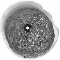
Posted by: Phil Stooke Sep 6 2017, 09:02 PM
The circular part of a circular projection is just Photoshop: Filter-Distort-Polar Coordinates. If you use it on a raw panorama you get what is usually referred to as a polar projection. Every vertical column of pixels is mapped onto a radial line from the projection center to the circumference. So the extreme foreshortening near the horizon is the same in the raw pan and the polar projection.
I perform an extra step for my circular projections, which is why I use a different name for them. I could call it Stooke's Fudged Polar Projection, but 'circular' is shorter. I change the radial scale so the outer part is greatly exaggerated and the inner part shrunk - in effect removing the foreshortening to create something a bit more like a map. It still contains a lot of relief distortion so it's not really a map-like geometry - to fix that you need a DEM. In the old days I left it like that, causing high features on the horizon to be greatly exaggerated in height. Now I shrink the horizon features a bit to try to create a horizon closer in appearance to the original panorama. A total fudgerooney. But I like the effect and it makes locations easy to compare with a HiRISE image.
Phil
Posted by: PaulH51 Sep 7 2017, 12:14 AM
Drive direction L-MastCam from sol 1807, looking towards the top of the rise.
Not sure if we'll have a clear view of the lower part of the mountain, towards those rounded buttes, after we clear this ridge? Maybe we have a few other small ridges to clear before we get that vista? I guess a wider map with contour lines would help
Raw colours, roughly stitched in MS ICE
|
Posted by: DeanM Sep 7 2017, 05:02 AM
Emily has added a great MSL write-up on the PS's blog:
http://www.planetary.org/blogs/emily-lakdawalla/2017/0906-curiosity-balky-drill-problem.html
"The engineering team has explored other methods of sample delivery, including dropping all the drilled sample on the ground and then attempting to scoop it up. If they can get the sample into the scoop, that puts it into CHIMRA for ordinary delivery. Unfortunately, the speed of the scoop works against this."
Is there anything stopping them from dropping the sample directly into the scoop (rather than dropping on the ground, then scooping)?
Dean
Posted by: RoverDriver Sep 7 2017, 03:01 PM
Is there anything stopping them from dropping the sample directly into the scoop (rather than dropping on the ground, then scooping)?
Dean
The scoop is on the turret, where the drill is. There's no combination of turret position that would allow a direct drop into the scoop. The sample *could* be dropped into the inlet but unsifted the sample would not be useable and could (would) clog the inlet. When the sample is scooped, it will get through the sieve and would be useable.
Paolo
Posted by: HSchirmer Sep 7 2017, 09:04 PM
Is there anything stopping them from dropping the sample directly into the scoop (rather than dropping on the ground, then scooping)?[/quote]
The scoop is on the turret, where the drill is. There's no combination of turret position that would allow a direct drop into the scoop. The sample *could* be dropped into the inlet but unsifted the sample would not be useable and could (would) clog the inlet. When the sample is scooped, it will get through the sieve and would be useable.
Here's a stupid question- Can the rover touch its toes?
Dump some of the sample on the front wheel, so the grousers retain it. Inspect the grain size with mahli, composition with APXS.
Position the scoop in front of the wheel, rotate the wheel forward and dump some sample off the grousers into the scoop.
Posted by: Phil Stooke Sep 7 2017, 10:48 PM
Interesting idea... but apart from the fact that it sounds way too dangerous for the safety of the arm, those grousers are zigzags, not straight lines, so the direction anything would fall off them would be difficult to predict.
Phil
Posted by: elakdawalla Sep 7 2017, 11:09 PM
Yeah I'd say this one is not possible also because of the tiny height of the grousers, combined with all the safety issues of even putting the turret so close to the wheel (which remember is on a suspension system that allows it to move dramatically up and down), much less driving with the turret in that position, but I have to give you points for creativity. It's a fun mental image, the rover using a grouser V to funnel sample into its scoop.
Posted by: RoverDriver Sep 8 2017, 03:49 AM
Dump some of the sample on the front wheel, so the grousers retain it. Inspect the grain size with mahli, composition with APXS.
Position the scoop in front of the wheel, rotate the wheel forward and dump some sample off the grousers into the scoop.
No, she cannot touch her toes. The LF wheel is too close to the arm shoulder and the RF wheel cannot be reached because of hardware (arm actuators) encroaching the rover body. Also, the rover cannot drive and use the arm at the same time. Even if this could be done, the suspension system would likely change the position of the front wheels as you drive even if you spin only one wheel. This could result in a collision with the scoop. Just the sheer quantity of PowerPoint presentations to explain such an accident would be sufficient for making me grow new hair and make it fall off again ;-)
On the other hand, there's a tray on the front of the vehicle that was designed and built to look at scooped samples. You scoop the sample, drop it on the tray and do MAHLI/APXS on the sample. I don't think anyone attempted to propose to drop a sample on the tray from the drill and scoop it up to sieve it. The issue is not APXS/MAHLI a sample (which you could do it in situ), but to sieve it, portion it, and drop it into SAM and CheMin.
Paolo
Posted by: Gerald Sep 8 2017, 05:58 AM
What about drilling more than one hole in order to get sufficient tailings for the scoop? Scoop subsequently in perpendicular direction, first create a narrow lengthy pile, then in a perpendicular way a higher pile with more potential of some tailings ending up in the scoop. Ideally scoop uphill, or better against an edge of an uneven rock. Select the drill target not just by geological considerations, but also by the topographical settings suitable for subsequent processing. Use Mars as a tool, related to the idea of sampling onto a sand ripple. Even using the scoop to move one or more small nearby stones to the pile would be an approach. It will require some patience, but better than no sample analysis.
Edit: Btw, did you consider to rotate the drill while removing it from the hole? This will reduce friction.
Posted by: RoverDriver Sep 8 2017, 06:21 AM
I think this is getting way out of topic. It is not that I do not want to continue the conversation, but believe me there are very smart engineers working on this which are considering all options. Paolo
Posted by: PaulH51 Sep 8 2017, 07:07 AM
Maybe time for a new thread
Sol 1809 Drive to Site 65/3308, NLB in MS ICE (raw)
|
Posted by: Zelenyikot Sep 8 2017, 08:25 AM
Sols 1751-1754-1807 drill moving.
|
Posted by: Sean Sep 8 2017, 10:20 AM
Made it! [ I hope... ]
https://flic.kr/p/Ygn27w
*surveys domain*
Posted by: TheAnt Sep 8 2017, 01:20 PM
I agree with RoverDriver, either they solve it, or they wont.
Even though some of the suggestions were interesting, it might be time to draw a line here. =)
Posted by: jvandriel Sep 8 2017, 06:46 PM
The Navcam L view on Sol 1809.
Jan van Driel
|
Posted by: Phil Stooke Sep 8 2017, 11:33 PM
A circular view of Jan's panorama, showing us making progress up the slope.
Phil
|
Posted by: atomoid Sep 9 2017, 12:32 AM
deja vu of the Home Plate ascent? such a nice view http://www.midnightplanets.com/web/MSL/image/01809/NLB_558097616EDR_F0653308NCAM07753M_.html stitch anaglyph/xeye for hecks..
|

|
Posted by: elakdawalla Sep 9 2017, 12:40 AM
Allllllmost there. Surely they'll stop at a good viewpoint to take some nice images before the ridge hides the Gale floor from view. I've been poking my friends on the mission to see if they'll get a self-portrait up here -- it's been a year since the last one. Nobody ever commits to actions in the future, of course, so nobody will commit, but I'm hoping.
Posted by: PaulH51 Sep 9 2017, 07:28 AM
Enjoyed the anaglyph (atomoid) and fingers crossed for that selfie Emily is wishing for, but right now I'd settle for the weekend plan before Monday.
Meanwhile: here's Curiosity's Sol 1809 (post-drive) L-MastCam Workspace, assembled in MS ICE without additional processing (raw)

|
Posted by: PaulH51 Sep 9 2017, 12:50 PM
1809 L-MastCam, drive direction mosaic, assembled in MS ICE, without additional processing (raw)
Looks like there are plenty of interesting targets ahead, but with no weekend mission update/plan, I'd guess there will be no more driving until early next week.
|
|
Posted by: PaulH51 Sep 10 2017, 11:05 PM
Nice (banded?) sedimentary bedrock seen in this pair of focus merged MAHLI's from sol 1811. Stitched in MS ICE, then rotated to roughly align with the view in the 1809 http://www.unmannedspaceflight.com/index.php?s=&showtopic=8309&view=findpost&p=237092 mosaic. I've identified the location on a reduced version of the L-MastCam mosaic.
Raw MAHLI images, no additional processing
|
|
Posted by: elakdawalla Sep 11 2017, 08:21 PM
After the drive on sol 1812 seemed like a good spot to split the threads; http://www.unmannedspaceflight.com/index.php?showtopic=8333.
Posted by: jvandriel Sep 11 2017, 09:03 PM
The Navcam L view on Sol 1812.
Jan van Driel
|
Posted by: Phil Stooke Sep 11 2017, 09:54 PM
What a great view we have here - and the crater rim is clearer than it has been for a long time. This is Jan's panorama in a circular version. We are still very close to the edge of the slope, moving almost parallel to the edge on sol 1812.
Phil
|
Posted by: PaulH51 Sep 12 2017, 03:48 AM
L-MastCam mosaic acquired before the drive to the top of the ridge on sol 1812 (MS ICE-sharpened)
|
|
Posted by: Sean Oct 20 2017, 02:58 PM
Here is a portrait of Mount Sharp from Sol 1785...
https://flic.kr/p/CveAZ9
and a 4k wallpaper...
https://flic.kr/p/ZBnQuP
Posted by: Sean Oct 20 2017, 04:07 PM
Sol 1785 landscape...
https://flic.kr/p/YAgehH
4k wallpaper...
https://flic.kr/p/YAgeBv
Powered by Invision Power Board (http://www.invisionboard.com)
© Invision Power Services (http://www.invisionpower.com)