Printable Version of Topic
Click here to view this topic in its original format
Unmanned Spaceflight.com _ Opportunity _ Spring at Cape York
Posted by: Phil Stooke May 13 2012, 12:11 PM
Time for a new topic, I think.
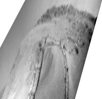
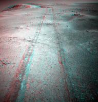
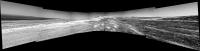
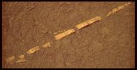
A bit of monkey business with the FHAZ from 2952 shows the nature of the latest drive.
Phil
|
Posted by: Phil Stooke May 13 2012, 12:22 PM
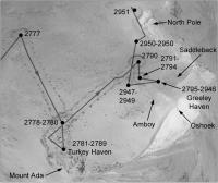
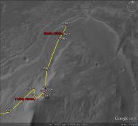
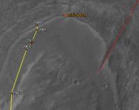
... and a map of recent activities. This is not geometrically precise (I'll leave that to Tim Parker), but it lets me organize information. Next step is to add some of the target names.
Phil
|
EDIT - map has been replaced with a corrected version
Posted by: mhoward May 13 2012, 04:49 PM
My approximation of where she is on sol 2951. I'm sure it's somewhat off.

|
Posted by: Phil Stooke May 13 2012, 05:56 PM
Oops - was that a 2951 drive? I'll update my map later.
Phil
Posted by: mhoward May 13 2012, 08:53 PM
Yes, 2952 is tosol/today.
Posted by: Phil Stooke May 14 2012, 01:40 AM
I have now replaced the picture in my second post with a corrected version of the map.
Phil
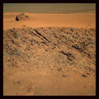
Posted by: CosmicRocker May 15 2012, 04:54 AM
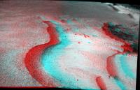
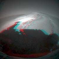
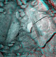
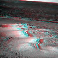
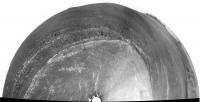
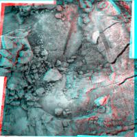
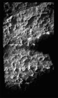
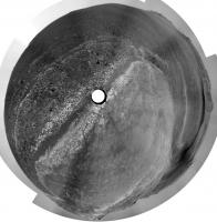
On sol 2949 Opportunity's Pancams imaged the target North Pole, which is the patch of dust to be investigated next. Attached is an L2R2 anaglyph of the most interesting part of that panorama. One of the L2 images suffered a dropout which I patched with a barely noticeable piece from the L5 image.
In 3D it is easy to see how this local topography created a wind trap for fine particulates.
|
Posted by: Stu May 15 2012, 11:16 AM
Really nice anaglyph, CR! 
In another view, having finallty escaped exile on Greeley Haven, it looks like Oppy is having a fine old time playing in the sandpit again..
|

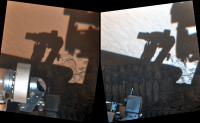
Posted by: mhoward May 15 2012, 01:13 PM
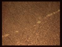
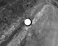
fhaz sol 2953
|
Posted by: fredk May 15 2012, 02:58 PM
I'm sure many of you have noticed the change in the timing of Exploratorium updates after the recent outage. The old 0-6-12-18 update schedule is gone, and now the updates come a bit later each day (presumably corresponding to the timing of the downlinks). Some of the images are now timestamped on Exploratorium very soon after they were taken - for example http://qt.exploratorium.edu/mars/opportunity/rear_hazcam/2012-05-15/1R390346401EFFBRB9P1302R0M1.JPG?sol2953 is timestamped 03:12 this morning, PDT. But the http://www.greuti.ch/oppy/html/filenames_ltst.htm says it was taken at 02:15 PDT. Just think about that for a moment - less than an hour after the image was taken on Mars, it's publicly available! 
I did like the regularity of the old schedule, but getting the newest images in almost real-time is seriously cool.
Posted by: mhoward May 15 2012, 03:19 PM
Agreed, Fred; this is about as good as it gets. Major thanks to the individuals at Exploratorium and NASA/JPL for getting the image pipeline working again. And ongoing thanks for the PANCAM database, without which several of us couldn't do much.
Posted by: Tesheiner May 16 2012, 01:32 PM
http://qt.exploratorium.edu/mars/opportunity/forward_hazcam/2012-05-15/1F390344313EFFBRB9P1214L0M1.JPG (2953) -> (2954) http://qt.exploratorium.edu/mars/opportunity/forward_hazcam/2012-05-16/1F390432365EFFBRC1P1214L0M1.JPG
Driving back uphill? 


Posted by: RoverDriver May 16 2012, 03:28 PM
Our IDD target is to our left but also need to reach some targets in the tracks at the same time. That makes for a difficult precision driving. We thought we could do it in a Sol but apparently it will take some time. Sorry!
Paolo
Posted by: fredk May 16 2012, 04:49 PM

No harm done, Paolo. It's not as if you're driving a robotic vehicle on another planet or anything!

Posted by: RoverDriver May 16 2012, 05:45 PM
I got the following question from Eduardo which I think it is interesting to others.
Sometimes we discussed at UMSF about what might be behind those FHAZ and RHAZ "fault" images which seems to be always sequenced on a driving sol but only executed from time to time. As far as I can see, some of them were taken thisol (seq-id 1354) and I presume (guess, actually
) they are triggered after a faulted drive. Excessive slip, currents, tilt? Which kind of events can trigger that sequence? Why Spirit (AFAIK) had no such thing? It's an interesting topic, at least to me and I guess to the others on the forum too, but I'm not sure if this is something which could be discussed / explained on the mainstream thread or is restricted to the mission people perhaps. That's the reason for this PM.If you say it's no problem to talk about it on the open forum, great! In this case I would raise the same questions there.
If not, fine too.
Un saludo,
Eduardo Tesheiner
I know how to answer this question!
p1254, p1354 are 4bpp FHAZ and RHAZ respectively taken only when we have a drive that completes with a fault of some sort to analyze the terrain to possibly help in interpreting the fault. For IDD we take p1154 if the IDD sequence has a fault (p12xx p13xx are for drives, p11xx are for IDD). In this case (sol 2954 drive) it is not really a fault, we just did not make enough progress forward before turning to the left. Since we did not want to turn prematurely and stomp on potential science targets we just stopped the vehicle and precluded any further motion. Since we did the IDD salute (raising the IDD turret to take an unobstructed view of the IDD work volume with a p1214) we could have skipped the p1254 but we left it there to preserve our sequence structure. One of the good things about having a reserved sequence number for events like these is that sequence numbers are one of the first things we see, it gives us more time to deal with a potential anomaly. Also, in case of an anomaly you might have little data to work with, this is a simple trick to let us know what happened. Since what fault conditions are acceptable and which are not is determined on a sol by sol basis, a p1254/1354/1154 does not necessarily mean we have an anomaly.
If anyone has questions like these just ask, I might be able/allowed to answer.
Paolo
Posted by: Stu May 16 2012, 06:25 PM
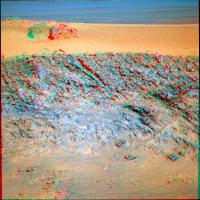
"Artistic" view of North Pole dunes...

|
Posted by: Phil Stooke May 16 2012, 07:51 PM
"Why Spirit (AFAIK) had no such thing?"
For the record, Spirit had zillions of faulted drives as well. I am in the process of going through every single day of sol summaries for Spirit (2210 of them) at the PDS MER Analyst's Notebook. Zillions!
Phil
Posted by: Tesheiner May 16 2012, 09:38 PM
Many thanks for the answers Paolo!
For the record, Spirit had zillions of faulted drives as well. I am in the process of going through every single day of sol summaries for Spirit (2210 of them) at the PDS MER Analyst's Notebook. Zillions!
Phil
Sure! For "thing" I was referring to fault image sequences, not aborted drives.
Posted by: RoverDriver May 16 2012, 09:51 PM
Spirit had of course her share of p1254 and the like (see the infamous A 1899 drive :-( as an example). While there was much order in the sequence numbers for science and for some of the other activities, we only recently introduced these "fault" F/R HAZ sequences. OK, recently in geologic sense, for Oppy we started using them around sol 1791 and for Spirit around sol 1866 for drives. The origin of this practice came from IDD sequences tho. We began doing it on sol 879 for Oppy and sol 861 for for Spirit. We saw that this practice was useful and extended it to drives. So, digging in the archives it seems that the originator of this practice is Chris Leger. http://www-robotics.jpl.nasa.gov/people/Chris_Leger/
Paolo
Posted by: walfy May 16 2012, 09:55 PM
A very quick mini-movie of a sequence from sol 2951: sol2951_series.mov ( 449.77K )
: 795
sol2951_series.mov ( 449.77K )
: 795
Posted by: mhoward May 17 2012, 02:00 PM
Nice drive on Sol 2955. I think they may be lined up with the target at "North Pole" now. (How does the song go? "I can't drive 2955?" Well the rover drivers have proven otherwise.)
|
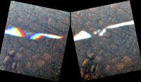
Posted by: Tesheiner May 17 2012, 02:40 PM
I like the shadows alignment on this FHAZ image.
|
Original: http://qt.exploratorium.edu/mars/opportunity/forward_hazcam/2012-05-17/1F390523674EFFBRCQP1214L0M1.JPG
Posted by: marsophile May 19 2012, 05:41 PM
The MTES has been unused because the lens is covered with dust. I wonder, though, if it could be used just to get an MTES spectrum of dust?
If so, that might provide some information that might be useful in conjunction with the APXS data on the dust.
Posted by: James Sorenson May 20 2012, 09:48 AM
Look's like some new contamination on the left front hazcam.
http://qt.exploratorium.edu/mars/opportunity/forward_hazcam/2012-05-19/1F390695039EFFBRCQP1110L0M1.JPG
http://qt.exploratorium.edu/mars/opportunity/forward_hazcam/2012-05-17/1F390523674EFFBRCQP1214L0M1.JPG
Posted by: RoverDriver May 20 2012, 10:47 AM
Those are bugs on the windshield. It happens when you resume  At the next gas station we will clean it up.
Seriously, it is possible that the dust particles were there already and the different lighting conditions are highlighting the dust specs more in the latter image. If not, they are in an area of the FHAZ that is less important (at least to me). The lower center (for IDD) and the lower sides (for soil/wheel interaction) are the areas I consider more essential.
Paolo
Posted by: Astro0 May 21 2012, 10:03 AM
Some OT posts about observing the Transit of Venus moved http://www.unmannedspaceflight.com/index.php?showtopic=7330.
Posted by: Tesheiner May 21 2012, 06:52 PM
(Don't remember when was the last time I posted a mosaic here...)
This one was taken yesterday, sol 2958, with the navcam.
|
Posted by: RoverDriver May 21 2012, 10:37 PM
Sigh, I was on shift today and no driving! On the other hand the IDD target that was picked was quite difficult to get to. I heard about the possibility of sequencing a drive on Wednesday. We'll see.
Paolo
Posted by: Stu May 22 2012, 06:37 PM
Farewell shot of "Greeley Haven"...
|
Posted by: Stu May 22 2012, 10:32 PM
Some rather nice new MI's came down... "artistic" mosaic...
|
Love the cracks in the dusty surface at the bottom there...
Posted by: RoverDriver May 22 2012, 11:25 PM
|
|
Love the cracks in the dusty surface at the bottom there...
Nice mosaic Stu. What software do you use?
Paolo
Posted by: Stu May 22 2012, 11:32 PM
Thanks Paolo. Well, I could tell you, but then I'd have to...
Software:
"Autostitch" to, well, stitch the frames together into a mosaic.
"Registax" to sharpen it up with the software's wavelet sharpening tool, and change the gamma, contrast and brightness.
"PS Elements" to change lighting effects and basically tweak and mess about with it until something that makes me smile comes out the other end.
Posted by: mhoward May 23 2012, 03:12 AM
Those new spots on the left front hazcam are gone as of sol 2960.
Posted by: RoverDriver May 23 2012, 03:48 AM
It was the guy with the squeegee that cleaned them up
Likely the spots are still there but teh lighting conditions are different.
Paolo
Posted by: brellis May 23 2012, 04:53 AM
Regarding Stu's Post #29 "Farewell" pic, that looks like a treacherous perch! I did have the good fortune to get run over by a MER rover at one of the JPL open houses several years ago, so I know Oppy's up to the task, but still -- after 8 years she's still quite a rock climber!
Posted by: RoverDriver May 23 2012, 05:03 AM
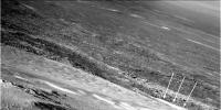
While the area was not that big, turning around proved difficult (we failed twice!). This is because the RF wheel steering actuator is no longer operational (we lost it around sol 300) so whenever we turn around we sort of drag the RF wheel. On rock so rough the rim of the wheel gets caught and turning around proves quite difficult. The slopes were not that high but the terrain surface we quite messy.
Paolo
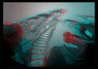
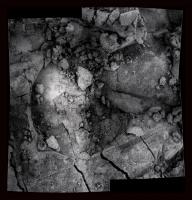
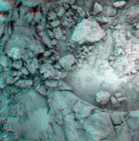
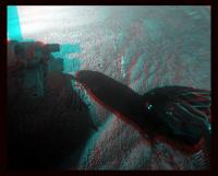
Posted by: walfy May 23 2012, 05:03 AM
Very nice new micros of the sandy patch. Or is it more like wind-blown dust that caked together? In any case, they render superbly in 3D!
|
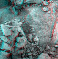
Posted by: walfy May 23 2012, 05:18 AM
Another micro from sol 2960:
|
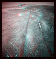
Posted by: walfy May 23 2012, 05:26 AM
Last one for today. Are those wheel tracks (the straight mini-trenches that nearly reach across the image, two of which are parallel)?
|
Posted by: Stu May 23 2012, 10:15 AM
Great anaglyphs, Walfy, love those!
Very special "thank you" to Paolo for providing me with some really useful (and detailed!) info about the story behind those MI images, which I've written a blog post around over on "Road to Endeavour" if anyone would like a look...
http://roadtoendeavour.wordpress.com/2012/05/23/a-sense-of-scale
Posted by: Stu May 23 2012, 10:58 AM
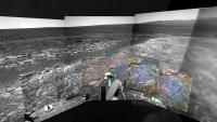
3D mosaic... just download it, put your glasses on, and scroll around it, imagining you're an ant on Mars...
|

Posted by: mhoward May 23 2012, 08:15 PM
Nice anaglyphs. The mosaic is impressive. Here's a Navcam view from today (sol 2961).
|
Posted by: mhoward May 23 2012, 08:39 PM
The sol 2949 look back at Greeley Haven, false color anaglyph.
|
Posted by: Tesheiner May 25 2012, 05:38 PM
If I read the data from today's drive correctly, Opportunity is currently 25m north of North Pole (is that possible? ).
FHAZ from sol 2963.
http://qt.exploratorium.edu/mars/opportunity/forward_hazcam/2012-05-25/1F391231763EFFBRFPP1212L0M1.JPG

Posted by: mhoward May 25 2012, 05:52 PM
Yeeha! What a day for a drive!
|
|
Posted by: Stu May 25 2012, 06:05 PM
...and downhill we go...

|
Posted by: fredk May 25 2012, 06:11 PM
...and will continue to by the look of the drive-direction pancams.
Posted by: Stu May 25 2012, 07:40 PM
Quick look around...
|
|
Posted by: brellis May 25 2012, 08:39 PM
Stu, are the hills in the distance to the left in your Post #48 image part of the North Rim of Endeavour Crater?
Posted by: RoverDriver May 25 2012, 08:59 PM
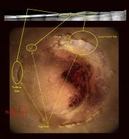
If I understand what you are asking, the answer is no. Endeavour has a small hill in the middle (actually a bit to the West of center). What you see is that hill. If you use Google Earth and switch to Mars, type in Endeavour you'll see that hill. In the center of this panorama you see Cape Tribulation (yeah!!) then moving to its right is what I believe could be Knobby's Head and finally Cape York. The 7x1 Navcam panorama was centered around 198deg.
Paolo
Posted by: Phil Stooke May 25 2012, 09:34 PM
Is the position of back-seat driver taken? I might have to check the map again, but...
Phil
Posted by: mhoward May 25 2012, 10:28 PM
Haven't done one of these in a while...
http://www.flickr.com/photos/marscat/7270143548/
http://www.flickr.com/photos/marscat/7270143548/ on Flickr
Posted by: Phil Stooke May 25 2012, 11:29 PM
Likewise!
Phil
|
This also adds to my 'backseat driver' post just above. This presentation of the pan shows what we are looking at - the hills referred to are indeed the north rim of Endeavour. We can also see the central mound on Endeavour as a dark ridge. Cape Tribulation and Nobby's Head are hidden behind Morris Hill, the top of Cape York.
Posted by: Stu May 26 2012, 10:18 AM
Just to clarify...
|
Posted by: RoverDriver May 26 2012, 12:44 PM
Stu, are you sure? The tracks left from Sol 2963, which are clearly visible in the panorama, are in a direction of about 200 degrees. I think that what you indicated as Eastern Far Side Hills is in fact Cape Tribulation.
Paolo
Posted by: Phil Stooke May 26 2012, 12:49 PM
200 clockwise from north, Paolo? - as in my circular pan above? I'm sorry but I think you are turned around a bit.
Phil
Posted by: Stu May 26 2012, 01:04 PM
Very sure Paolo, yes. The Eastern Hills are dominated by that large, oval-shaped (STILL un-named!!!) crater, which faces the western side of Endeavour. Oppy has been looking at - and watched over by - that crater ever since she arrived at Cape York. Tribulation is on this same side as Cape York, south of where we are now, but hidden at the moment by the lie of the land.
Posted by: mhoward May 26 2012, 01:40 PM
200 degrees from north for the rover tracks is correct; it's just that Cape York is blocking the view of the rim past about 165 degrees from north. I think maybe the most southern part of the west rim is just visible, but I don't think Tribulation is.
Posted by: Phil Stooke May 26 2012, 01:59 PM
Paolo's comments suggest he was thinking of 200 degrees from west. But don't worry, folks, no harm done. It's not like we're heading back to Victoria crater by mistake! (or are we?)
Phil
Posted by: RoverDriver May 26 2012, 02:23 PM
I am 100% sure that the tracks are 200 degrees compass heading (20 degrees West of South) but I think you are right. NAVCAM mosaics are spaced 36 deg so you are right! I apologize.
Paolo
Posted by: Stu May 26 2012, 02:50 PM
Don't apologise Paolo, we're all thrilled you're here. And if you want to drive over *there* feel free, I'd love a look at those hills close-up!
Posted by: fredk May 26 2012, 03:28 PM
It's definitely easy to loose track of azimuth in a navcam pan presented at such a small scale!
Here's a comparison with a pan from Greeley so we can see how Tribulation is just barely obstructed by Morris Hill now:
|
|
(Both pans from mhoward.)
Posted by: mhoward May 26 2012, 04:19 PM
Great idea fredk; I wish I'd thought of that.
Posted by: eoincampbell May 26 2012, 04:41 PM
I'd be utterly confused as to rover positioning without the ongoing work by UMSF image wizards, so cheers to all, looking forward to the upcoming drives
Posted by: brellis May 26 2012, 10:10 PM
UMSF PanCam Experts are Awesome!!
Posted by: RoverDriver May 26 2012, 11:08 PM
Some serious driving is in the works. By noon (PDT) on Sunday we should know if we got it all in. Rolling, rolling, rolling...
Paolo
Posted by: nprev May 26 2012, 11:45 PM
Roll on, Paolo! (Great to see you back on UMSF, BTW, hope all is well!)
Posted by: RoverDriver May 27 2012, 01:17 AM
(Great to see you back on UMSF, BTW, hope all is well!)I'm all right but a bit too busy with MSL to enjoy driving Oppy. My next shift is on June 6th!
Paolo
Posted by: Phil Stooke May 27 2012, 07:19 PM
Wow, found a vein already?
Phil
http://qt.exploratorium.edu/mars/opportunity/forward_hazcam/2012-05-27/1F391414787EFFBRLMP1212R0M1.JPG
They're all over the place:
http://qt.exploratorium.edu/mars/opportunity/navcam/2012-05-27/1N391408016EFFBRLMP0615R0M1.JPG
Posted by: mhoward May 27 2012, 08:17 PM
Sol 2965
http://www.flickr.com/photos/marscat/7281734640/
http://www.flickr.com/photos/marscat/7281734640/ on Flickr
Posted by: Tesheiner May 27 2012, 08:19 PM
<...>
They're all over the place:
That's what I thought too.
Paolo
Where's the "Like" button?
I measured about 50m NNE and it's confirmed by the pancam database. Route map update in a minute.
Posted by: RoverDriver May 27 2012, 08:21 PM
Sol 2965 was only 50.5 meters, it was cut short because we hit the lower limit for northerly tilt. This was one of the expected possible result, so today we have nominal F/R HAZ.
Paolo
Posted by: mhoward May 27 2012, 08:31 PM
50 meters sounds pretty good to me! Azimuth of the drive was about 18º from north according to the metadata.
http://www.flickr.com/photos/marscat/7281819590/
http://www.flickr.com/photos/marscat/7281819590/ on Flickr
Posted by: Phil Stooke May 27 2012, 08:51 PM
Here is mhoward's half pan in semicircular format.
Phil
|
Posted by: brellis May 27 2012, 09:33 PM
Thanks for the map update, Tesh. I was pointed completely upside down with my previous question. I am not unfamiliar with such revelations here on our home planet
Posted by: RoverDriver May 27 2012, 09:41 PM
I second that. You have no idea how many times I refer to the USMF maps on top of the ones we have, including last Wednesday! Thanks!
Paolo
Posted by: Stu May 27 2012, 10:31 PM
Oooh, nice...
|
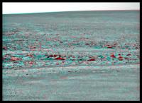
Posted by: Stu May 29 2012, 10:44 PM
I love these shots where you can see Oppy's tracks tracing out the contours of the landscape, that let you imagine how she bounced up and down as she drove in and out of hollows, over ripples etc...
|
Posted by: RoverDriver May 30 2012, 12:14 AM
When I assembled the p1994 I did use the accelerometer telemetry to generate the associated sound. Much like for a phonographic recording, I used the Z value from the accels as the difference between the Left and Right side and the RMS of the X and Y values as the sum of the Left and Right to compute the two channels, I put everything into a WAV file and use LAME to convert it to mp3.
If we start driving on something interesting I will assemble more of these "sounds from mars".
Paolo
Posted by: mhoward May 30 2012, 01:14 AM
I love this view.
http://www.flickr.com/photos/marscat/7298773542/
http://www.flickr.com/photos/marscat/7298773542/ on Flickr
Posted by: brellis May 30 2012, 02:18 AM
Paolo
New favorite anticipated Mars info
Posted by: walfy May 31 2012, 06:17 AM
Wow, turn away for a few days and miss something! Nice roiling rocks in view, just off the Cape.
|
And we're ever so closer to the whale spout, due east. That is indeed an interesting feature.
Posted by: walfy May 31 2012, 06:35 AM
Thought I'd give this a try with my meager Photoshop skills. For what it's worth, the micros from sol 2960 again as 3D mosaic:
|
Looks like the micro camera shot the left side from different angle than the right, as those planes are not parallel.
We love you, Oppy! What an awesome little robot.
Posted by: RoverDriver May 31 2012, 10:46 AM
Looks like the micro camera shot the left side from different angle than the right, as those planes are not parallel.
...
That is correct. Since Oppy's Az actuator no longer works the way we shoot 2x2 (or 2xn in general) is to turn the turret 5 deg to the left then turn 5 deg to the right from the center plane where the IDD can move. The two stacks (see my interview with Stu where I explain what an MI stack is) are shot with the boresight a total of 10 deg apart which make the two frames about 25mm apart. The two stacks are not parallel to each other but the resulting geometric distortion is small enough that can be removed on the ground. In fact the major issue is not stitching two stacks together but the fact that the within a single MI stack each frame is centered in a slightly different position which makes certain surfaces quite difficult to image (Winter haven MI mosaic is one good example).
Paolo
Posted by: mhoward May 31 2012, 01:52 PM
The full 360x90º Navcam panorama for sol 2965:
http://www.flickr.com/photos/marscat/7308119486/
http://www.flickr.com/photos/marscat/7308119486/ on Flickr
Posted by: mhoward May 31 2012, 02:06 PM
Sol 2967 Pancam foreground stereo pair
|
Posted by: Phil Stooke May 31 2012, 04:37 PM
A sprinkle of magic dust and mhoward's pan is turned into this:
|
|
Phil
Posted by: vikingmars May 31 2012, 10:35 PM
Thanks a lot Phil for those nice views !
By the way, see how "crystal clear" is the horizon now ! I hope they will do soon an horizon panorama with the L7 filter...
|
|
Enjoy
Posted by: mhoward May 31 2012, 11:56 PM
Drive direction on sol 2969 was roughly azimuth 40º

|
Posted by: fredk Jun 1 2012, 12:43 AM
Posted by: ElkGroveDan Jun 1 2012, 02:17 AM
http://www.unmannedspaceflight.com/index.php?act=attach&type=post&id=26866
Whatever that is, it's really soft. It appears the sides of the RAT hole just crumbled into the center after it was removed. Now what about that vertical impression on the right? Was that something on the IDD? or is it a natural feature?
Posted by: Phil Stooke Jun 1 2012, 03:06 AM
This is in the rover tracks, it's a wheel impression.
Phil
Posted by: fredk Jun 2 2012, 11:41 PM
Looks like a short drive back south on 2971 - perhaps to check whether this gypsum vein is wide enough for IDD work?
http://qt.exploratorium.edu/mars/opportunity/forward_hazcam/2012-06-02/1F391944176EFFBRNAP1211R0M1.JPG?sol2971
Posted by: RoverDriver Jun 3 2012, 01:41 AM
Yep, that's what we are trying to do. Possibly we will need one more bump before IDD work can begin. That's what you get with a 4 DOF (degrees of freedom) arm.
Paolo
Posted by: Tesheiner Jun 3 2012, 08:31 AM
The images are still on the queue but I presume the vein is what has been labeled Monte Cristo; an island with a massive hidden treasure (from the http://en.wikipedia.org/wiki/The_Count_of_Monte_Cristo).
02971::p2363::30::40::40::0::0::2::82::pancam_Monte_Cristo_3x1_L234567Rall
Posted by: jvandriel Jun 3 2012, 08:36 AM
Looking back through the eyes of the L1 Pancam on Sol 2967.
Jan van Driel
|
Posted by: Tesheiner Jun 3 2012, 05:18 PM
Last month's report by Salley Rayl is available here (*): http://www.planetary.org/blogs/guest-blogs/a-j-s-rayl/mars-exploration-rovers.html.
Some tidbits about the vein we drove over this weekend.
And about phyllosilicates:
(*) Couldn't find a permalink.
Posted by: mhoward Jun 3 2012, 06:57 PM
A question for Paolo, out of curiosity: I notice you've been taking some overlapping Pancam images of the veins recently. For example, the '3x1' Pancam mosaic of Monte Cristo actually has four camera pointings, the center two of which overlap at a slight offset. Is that about some different way of obtaining stereo, or what's up with that?
Posted by: stevesliva Jun 3 2012, 07:02 PM
^ I thought it had to do with dust on the camera.
Posted by: RoverDriver Jun 4 2012, 01:25 AM
I have not been on shift lately but the PANCAMs are now quite dusty and IIRC we use only about 10 degrees of horizontal field of view for critical observations. I could well be mistaken tho. I will ask around and let you know.
Paolo
Posted by: mhoward Jun 4 2012, 05:20 PM
Not a big deal, Paolo, we know you've got stuff to do. Getting around dust contamination would make sense, I guess.
Posted by: vikingmars Jun 5 2012, 06:02 AM
Sol 2965 : the horizon is still crystal clear (quick & raw outline herewith) : features located more than 30 km away (including the Iazu Crater rim) seem to be visible !
===> I'd really like the Rover team to take an L7 PanCam horizon look around the rim of Endeavour before it goes dusty...
|
|
Posted by: Stu Jun 6 2012, 12:18 AM
Colour image of gypsum vein...
|
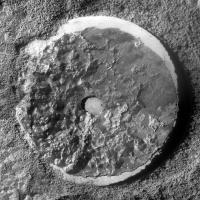
Posted by: Tesheiner Jun 6 2012, 11:11 AM
From sol 2974: In action taking MIs of "Monte Cristo".
http://qt.exploratorium.edu/mars/opportunity/forward_hazcam/2012-06-05/1F392204567EFFBRNAP1110L0M1.JPG http://qt.exploratorium.edu/mars/opportunity/micro_imager/2012-06-05/1M392204085EFFBRNAP2935M2M2.JPG

Posted by: Stu Jun 6 2012, 12:01 PM
"Monte Cristo" MI mosaic...
|
Posted by: Stu Jun 7 2012, 03:37 PM
"Monte Cristo" in all its glory...

|
Posted by: Phil Stooke Jun 7 2012, 04:06 PM
Nice one, Stu!
Phil
Posted by: walfy Jun 8 2012, 06:33 PM
A micro from sol 2974, "Monte Cristo":

|
Posted by: RoverDriver Jun 8 2012, 07:48 PM
Darn! Nowadays I get one shift every two weeks or so. Today I was on shift and no driving due to ODY being in safe mode!  My next shift is in three weeks!
Paolo
Posted by: Phil Stooke Jun 9 2012, 11:01 AM
That safe mode could last until August, they say now. Ready in time for Curiosity's landing, but not good news for Opportunity.
Phil
Posted by: Stu Jun 9 2012, 12:31 PM
The latest PDS release covers Sols 2701-2790, which includs the time Oppy spent approaching, studying and then destroying "Homestake"... A couple of pics made using the PDS images, shown here in advance of Oppy spotting a bigger, fatter "Homestake" to use her instruments on...
|

|
Very pleased with the second one - first time I've been able to see and bring out the "sparkly bits" referred to by the rover team
Posted by: Floyd Jun 9 2012, 01:59 PM
Phil
The report on the Odyssey site doesn't seem that dire: "NASA's Mars Odyssey orbiter put itself into a precautionary standby status early Friday, June 8, Universal Time (Thursday evening, Pacific Time), when the spacecraft detected unexpected characteristics in movement of one of its reaction wheels. The spacecraft uses three of these wheels as the primary method for adjusting and maintaining its orientation. It carries a spare reaction wheel.""The spacecraft is safe, and information we've received from it indicates the problem is limited to a single reaction wheel," said Odyssey Mission Manager Chris Potts of NASA's Jet Propulsion Laboratory, Pasadena, Calif. "The path forward is evaluating the health of the reaction wheel and our options for proceeding."
Hopefully that means a week or so unless you have more specific information Phil.
Posted by: Phil Stooke Jun 9 2012, 02:02 PM
I was going by this, maybe a bit alarmist...
http://news.yahoo.com/nasa-troubleshoots-problem-mars-odyssey-orbiter-232759130.html
Phil
Posted by: mhoward Jun 9 2012, 02:13 PM
Perhaps to journalists, publicists and the general public, the main point is that it should be operating normally when Curiosity gets there. Of course the rest of us would like to see it operating normally considerably before then 
Posted by: Matt Lenda Jun 10 2012, 04:09 PM
Hopefully that means a week or so unless you have more specific information Phil.
That's the feeling I'm getting around the office. Chris isn't hiding anything in his oh-so-very-PR statement! It was just a bit of funny data that the spacecraft didn't like.
She's an old bird, the one...
Needless to say the MSL folks are a little rattled.
-m
Posted by: elakdawalla Jun 11 2012, 08:34 PM
It's kind of amazing to me that with all the electronic complexity of spacecraft, one of the things that most reliably fails is....THE WHEEL. Hayabusa, FUSE, Cassini....Seriously, you'd think humans would've got the hang of The Wheel by now.
Posted by: Floyd Jun 11 2012, 11:17 PM
Does anyone know if the WHEELS have magnetic or ball bearings? Is it the bearings that usually fail, or some other component?
Posted by: Matt Lenda Jun 12 2012, 04:51 AM
Usually magnetic, to reduce all friction that you can. There's even the concept of "stiction" across the 0-rpm boundary, when the wheel is spinning very slowly but then crosses 0-rpm and goes the other direction -- even great reaction wheels can get a little "stuck" at that point. Some missions can have attitude control systems that will explicitly avoid 0-crossings, but it often cannot be avoided, depending on your pointing profile.
Wheels are indeed tricky -- just ask Oppy!
-m
Posted by: Tesheiner Jun 14 2012, 06:24 AM
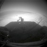
Just a pair of F/RHAZ pics came down on the last batch, but confirming that Opportunity is now located quite close to the edge.

|
Original: http://qt.exploratorium.edu/mars/opportunity/rear_hazcam/2012-06-13/1R392836859EFFBRP9P1312L0M1.JPG
|
Posted by: RoverDriver Jun 14 2012, 06:03 PM
If you are asking about the reaction wheels on ODY, I have no idea, on MER drive/steer actuators they have bearings and magnetic detents. In Oppy's RF steering actuator it is believed that the magnetic detent came loose and prevents motion, while in Oppy's IDD Az actuator we have reasons to believe it is one of the windings that is no longer operational. In Spirit's RF and RR drive actuator it is less clear but the best explanation I have heard is that there is some kind of deposit on the commutators which prevent current to flow through the windings.
Paolo
Posted by: MarkG Jun 15 2012, 12:33 AM
This "edge", the contact between the Meridiani deposits and the Endeavor rim deposits, is actually one of the most interesting possible things to look at. How much Opportunity's remaining instrumentation can glean is a "good topic of discussion", but this contact could tell us a lot about an era or two of Marian history....
Posted by: marsophile Jun 15 2012, 03:46 AM
Speaking of remaining instrumentation, I wonder if there could be some kind of creative use of the miniTES, even though the lens is covered with dust. Could it at least detect thermal radiation from "hot spots" at night, for example? Or does it, by now, have additional problems beyond the dirty lens that render it totally inoperable?
Posted by: djellison Jun 15 2012, 05:56 AM
It's not just dust. MiniTES is actually broken - it doesn't work anymore.
Posted by: jamescanvin Jun 15 2012, 08:50 AM
Steve Squyres reports on Twitter (@NEEMO_Steve) (from underwater!) that Oppy just had a big cleaning event!
Posted by: mhoward Jun 15 2012, 12:43 PM
Now there's some welcome news! I always thought this area to the north of CY 'looked' windy, although I'm sure this is probably just random timing. Hooray!
There's a look back at Cape York on sol 2981 that will be lovely once it's downloaded.
|
Posted by: climber Jun 15 2012, 01:08 PM
I also though the rim "has to be windy" but you've also got to consider the solar panel angle to the wind. I never thought this particular location would be windy so, yes, random is a possibility!
This cleaning occured right on time for Oppy to participate to the "24 heures du Mans: http://www.racing-1.com/2012/06/15/24-heures-du-mans-2012-classement-qualifications-audi-decroche-la-pole/
Posted by: marsophile Jun 16 2012, 03:00 AM
An exposed area is always likely to be more windy than a sheltered area.
Posted by: brellis Jun 16 2012, 03:41 AM
hmm, if we want Opportunity to last as long as possible, would that knowledge point us in a different direction for survival's sake?
Posted by: PaulM Jun 16 2012, 07:19 AM
There is a place to which Oppy could drive to ensure survival. Unfortunately there are no clays there. Winds have been observed over the last decade eroding sand dunes on the floor of Endeavour crater between Cape Tribulation and the central peak.
http://www.agu.org/pubs/crossref/2011/2010JE003675.shtml
I think that Oppy takes super-res photos of these dunes from time to time.
If Oppy became stationary then this would be the best place for Oppy to get stuck A time lapse film of a dune being eroded by wind over several years would be interesting.
Posted by: ElkGroveDan Jun 16 2012, 12:53 PM
Anyone see any numbers on this yet?
Posted by: Phil Stooke Jun 16 2012, 02:12 PM
Any wind that might erode a dune inside Endeavour could also clean a rover on its rim. It may be true that "An exposed area is always likely to be more windy than a sheltered area." but it's not so obvious where these places would be, and Cape York is not sheltered by anything. Spirit received a huge cleaning event while 'sheltered' between Home Plate and a nearby hill called Tsiolkovsky. And the dune fields inside Endurance and Victoria were clearly sculpted by winds despite being on crater floors. In short - cleaning events can happen pretty much anywhere so no need to panic.
Phil
Posted by: marsophile Jun 16 2012, 05:14 PM
Differential heating between light and dark areas can also produce winds. The area in the figure in the above paper seems to be such a transition area.
It may be fortuitous that Oppy right now is also near a boundary between light and dark regions.
What constitutes a "sheltered area" depends on the direction of the wind, which may change seasonally. Wind is not random if we understand the mechanisms involved.
Posted by: fredk Jun 16 2012, 06:18 PM
The topography of CY is so subtle that I think seasonal effects are the cause here. Remember we started to get cleaning events back at Greeley Haven. But we've also had big cleaning events about one and two Martian years ago. We're due for gusts and a big increase in tau around now...
Posted by: Oersted Jun 16 2012, 11:19 PM
I'll miss all the talk about the winds and cleaning events and jumping from lily pad to lily pad when we go from MER to MSL....
MER = the era of sail
MSL = the era of the nuclear submarine...
Posted by: fredk Jun 17 2012, 12:26 AM
Me too. But the half-life of 238Pu is only about 88 years. So in a couple of centuries the real advantage of solar power will be clear, as MSL becomes a lander and then goes silent, while Oppy continues her exploration of Miyamoto crater...
Posted by: climber Jun 17 2012, 05:37 AM
MER = the era of sail
MSL = the era of the nuclear submarine...
What about Steve S been in NEEMO right now?

Posted by: climber Jun 17 2012, 03:10 PM
Phil
interesting since I thought the oposite! Spirit was sitting between two ridges/hills and I thought it was a Venturi effect.
Posted by: Phil Stooke Jun 17 2012, 05:06 PM
Whatever the mechanism it was still a cleaning event!
Phil
Posted by: Phil Stooke Jun 19 2012, 06:26 PM
... Don't you hate it when there are no pictures???
Phil
Posted by: eoincampbell Jun 19 2012, 07:04 PM
While waiting on the pictures, I'm passing the time playing 'guess the energy production' until we get the new update...
Posted by: fredk Jun 19 2012, 10:41 PM
I feel your pain, Phil! At least we can take some old pics, polish them up a bit, apply some transformations, and repost them, tricking that part of the brain that needs new images, if only for a moment...
Here's mhoward's navcam pan from 2965 cropped and 3x vertical stretched, to remind us that we're still perched at the edge of one whopper of a crater:
|
|
Posted by: Phil Stooke Jun 19 2012, 11:15 PM
"I feel your pain, Phil! At least we can..."
Hmm, yes, that just might work!
I'm trying to follow my Gusev rim panorama with a version from the sol 2220s region where Bopolu, Miyamoto and Endeavour were all visible simultaneously.
Phil
Posted by: Phil Stooke Jun 19 2012, 11:17 PM
Also - Fred's pic of the crater floor reminded me to post this... first, the abstacts for the Planetary Dunes workshop:
http://www.lpi.usra.edu/meetings/dunes2012/pdf/program.pdf
And then this gem:
http://www.lpi.usra.edu/meetings/dunes2012/pdf/7038.pdf
Phil
Posted by: mhoward Jun 20 2012, 01:14 PM
Well, if we're really desperate, there's thumbnails.
Thanks for the links, Phil.
|
Posted by: mhoward Jun 20 2012, 01:34 PM
... and a model shot.
http://www.flickr.com/photos/marscat/7407747858/
http://www.flickr.com/photos/marscat/7407747858/ on Flickr
Posted by: Floyd Jun 20 2012, 04:32 PM
Good news regarding Odyssey http://www.nasa.gov/mission_pages/odyssey/odyssey20120619.html
"PASADENA, Calif. -- NASA's Mars Odyssey orbiter has been taken out of a protective status called safe mode. Remaining steps toward resuming all normal spacecraft activities will probably be completed by nextweek.
Controllerswill continue characterizing the performance of the replacement wheel in coming days while assessing which other activities of the spacecraft, besides nadir pointing, can be performed reliably with reaction-wheel control of attitude.
In returning to full service, Odyssey will first resume its communication relay function for NASA's Mars Exploration Rover Opportunity, and then will resume the orbiter's own scientific observations of Mars. As a priority, activities will resume for preparing Odyssey to serve as acommunications relay for NASA Mars Science Laboratory mission. "
Posted by: fredk Jun 21 2012, 05:59 PM
...and love it when they're back?
A short drive farther north onto the "shoreline" of CY on 2989:http://marsrovers.jpl.nasa.gov/gallery/all/1/n/2989/1N393538138EFFBRQ2P0635R0M1.JPG
Posted by: climber Jun 21 2012, 06:26 PM
I love this view, thanks Fredk
Posted by: stewjack Jun 21 2012, 08:17 PM
Just to make certain that I am not turned around - are we looking toward the red dot from the "shoreline" of CY on that sol 2989 image?
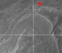
|
Jack
Posted by: fredk Jun 21 2012, 08:38 PM
That looks about right.
Posted by: stewjack Jun 21 2012, 09:46 PM
Thanks fredk. My track record of matching low-relief terrains is very poor. However, that match looked to-good-to-be-true.
Jack
Posted by: Tesheiner Jun 22 2012, 06:53 AM
Here's the navcam mosaic.

|
Posted by: Stu Jun 22 2012, 12:25 PM
Shattered/cracked rocks at Oppy's 'feet'...

|
Posted by: algorimancer Jun 22 2012, 01:11 PM
Now that the "Wedge" (aka several other names) is clearly within reach, I find myself wondering: how would we distinguish between a small fluvial gully (unlikely) and a fracture-based gully (likely), much less a fluvial feature which happened to flow through an existing fracture? The obvious distinguishing characteristics of a fluvial feature on at this scale, the flow-shaped sand and silt on the floor, would have long ago been wind-eroded and partially buried by dust and dunes over time, and water-smoothing of rocks in unlikely if water flowed only briefly. It seems to me that the null hypothesis would be to assume it is fracture-based, and the only way to rule it out would be if a cross-section of the floor sediment happened to be exposed, perhaps by a small crater or intersecting fracture, and clearly fluvial-derived layering were visible. At this point, Occam's Razor has me firmly convinced that it's a fracture feature, but it would be interesting to learn otherwise.
Posted by: john_s Jun 22 2012, 02:16 PM
i wouldn't be surprised if the "wedge" turns out not to be a gully or depression at all...
John
Posted by: marsophile Jun 22 2012, 03:03 PM
If there is a continuation of a shallow depression up into the hills (possible in the HIRISE image), that might be a piece of evidence suggesting a filled-in gully.
Posted by: Phil Stooke Jun 22 2012, 05:22 PM
I think that, to be realistic about geomorphological processes in an area like this, with plenty of evidence of erosion since Noachian times (see Golombek's recent paper on crater ages in Meridiani, saying basically all Hesperian craters are completely eroded away, Erebus etc. are Noachian), a Noachian gully on this scale would not have survived. Filling it with debris and exhuming it recently is too ad hoc. A fracture induced by the impact forming the crater Antares just to the north, or a gouge created by its ejecta, is much more likely.
Phil
Posted by: CosmicRocker Jun 23 2012, 06:07 AM
It seems likely to me that this notch is a relatively recent feature created by aeolian erosion along a zone of weakness such as a fracture. By recent, I mean tens of thousands of years to perhaps a few million years old at the most. I hope we'll get a close enough look at it to see if fracturing is involved.
At the very northern tip of Cape York is an almost insignificant geomorphic feature that I have been calling the mini-Notch. It looks like a minor, wind-eroded gully that is oriented in roughly the same NE/SW direction as the main notch or wedge. This suggests the possibility of an underlying structural "grain" that could be controlling the orientation of zones or planes of weakness in the bedrock. We already know that the rock is fractured because the calcite veins appear to be fracture fillings. However, I haven't noticed many of the calcite veins oriented in the same direction as the notch.
We seem to be heading in the general direction of this mini-notch. It's only about 120 feet to the ENE, so perhaps Oppy will slow down for a few pics if she passes by.
|
Posted by: fredk Jun 23 2012, 02:55 PM
I've been eyeing that mininotch too, Rocker...
Great news in the http://marsrovers.jpl.nasa.gov/mission/status_opportunityAll.html#sol2981:
Posted by: ngunn Jun 23 2012, 03:55 PM
There seems to be an inner and an outer bench at this part of Cape York. I'd expect them to continue northward to look at the edge of the outer one before heading SE towards both notches.
Posted by: Stu Jun 23 2012, 09:14 PM
Couple of MI frames came back... tried my best to make something out of them...
|
Posted by: Sunspot Jun 24 2012, 12:09 PM
John
I don't think it is either.
If you look at the "bath tub ring" around Cape York, from HiRISE you get the impression that there is a small vertical "step" like feature surrounding the Cape, but images from Opportunity show no such thing. I think the Gully is probably just a"slice" out of the white outcrop with no vertical relief at all. probably

Posted by: Stu Jun 24 2012, 12:36 PM
Well that peed on our chips, didn't it?
Posted by: fredk Jun 24 2012, 02:46 PM
Don't give up hope yet, Stu! I think there is some relief. Remember when we first made landfall on CY almost a year ago, there was a bit of a step up - check out the vertical stretch in http://www.unmannedspaceflight.com/index.php?s=&showtopic=6897&view=findpost&p=177165
We had a good look at Whim Creek (the wedge/notch) on 2917. The sun was low in the west and it really looks to me like the far side of Whim Creek is sloped towards the west since it's very bright (arrowed feature):
|
So I'm betting for some relief, but nothing too dramatic - this is Meridiani, after all!
Posted by: CosmicRocker Jun 25 2012, 04:36 AM
There is undoubtedly some relief at the notch, but I would have to agree that there is less relief than we were expecting when Cape York was first announced as Opportunity's next goal after Victoria.
Of course, none of us were surprised by Cape York's lack of relief, either.
Posted by: MarkG Jun 25 2012, 06:24 PM
Well, I think that the "dagger" will turn out to be a very old filled slump crack in the rim. If the Endeavor crater was formed amidst the process that was depositing the Meridiani sediment, the details of the "dagger" fill could be instructive, since they would be kind of a snapshot of the time. (Since the "dagger" extends into the Meridiani sediment a ways, it is younger than the rim, but probably older than the end of the Merdidiani deposition.)
Posted by: ElkGroveDan Jun 25 2012, 06:40 PM
Well phhhhtttt! on all of you. I'll go out on a limb and depart from the nose-in-the-air, poo-poo chorus. I think it's an aqueous erosional feature (likely buried and exhumed several times) that was created as water drained from Meridiani over and around Cape York into Endeavor Crater.
Go ahead and laugh. They laughed when I said I wanted to be a comedian, but no one's laughing now.
Posted by: mhoward Jun 25 2012, 06:48 PM
Right on, Dan. We'll see what it is (maybe) when we get there.
Anyone who was expecting gypsum veins prior to arrival, please weigh in on this issue.
Posted by: ngunn Jun 25 2012, 07:29 PM
It's a vent emitting psychotropic gases, as at Delphi. When we get there we'll learn what we don't know.
Posted by: fredk Jun 25 2012, 08:50 PM
OK, if you want to know what I really think it is, parsimony dictates that it's an outlet for the Abyss in the Columbia Hills near our resting friend, Spirit. Fluids spiral down into the Abyss, through the Martian core, and empty out here. The fact that the flow pattern from the notch appears to be horizontal rather than downhill into Endeavour is easily explained by ngunn's psychotropic gases.
So is there a name to the rule that the signal-to-noise on this forum drops and silliness goes up whenever new pics are scarce?
Posted by: Oersted Jun 25 2012, 10:45 PM
No relief in sight, you say? - Nothing that a bit of a stretch can't solve is my answer...
Posted by: nprev Jun 25 2012, 11:18 PM
Fred, the rule is unwritten but can be summarized by the following: 
Patience, all, patience...
Posted by: Astro0 Jun 25 2012, 11:22 PM
> So is there a name to the rule that the signal-to-noise on this forum drops and silliness goes up whenever new pics are scarce?
Exploratorium Withdrawal Physcosis:
A psychiatric disorder that is marked by delusions, hallucinations, incoherence, distorted perceptions of reality and posting silly things when the individual cannot see or manipulate images from a distant planet.
Posted by: Phil Stooke Jun 25 2012, 11:38 PM
If we don't get a fix soon it will be "patients, all patients"
Phil
Posted by: MarkG Jun 26 2012, 03:15 AM
In keeping with the current discussion...
EGD,
I'll see your "phhhhtttt!" and raise you a "BWHAHAHAHA!"
It is the scar made by Martians doing a wheelie in their ground transport unicycles, after laughing at the primitive Earth contraptions showing up...
Posted by: Zeke4ther Jun 26 2012, 05:01 AM
These are not the 'droids you are looking for.
Move along, move along....
Posted by: CosmicRocker Jun 26 2012, 05:36 AM
Whatever the reason for the inspired humor around here, I'm all for it.
Posted by: Fran Ontanaya Jun 27 2012, 02:11 AM
I'll put my money on "nest dug by http://www.unmannedspaceflight.com/index.php?showtopic=4927&view=findpost&p=108306 to lay its eggs".
Posted by: Tesheiner Jun 27 2012, 06:52 AM
Ok, back to business. The exploratorium may be somehow stuck but the images pipeline to the mission's website is working.
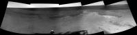
Here's a 360deg. navcam mosaic from our current site.
|
|
And looking to the imaging sequences planned to thisol, it seems that some RAT activities are scheduled.
02995::p1110::02::2::0::0::2::0::4::front_haz_mi_1024x1024x1bpp_pri56
02995::p1121::03::2::0::2::0::0::4::fhaz_idd_apxs_doc_512x512x1bpp_pri56
02995::p1140::02::2::2::0::0::0::4::front_hazcam_rat_doc_sbfrm_4bpp_crit
02995::p1141::00::2::0::2::0::0::4::front_haz_idd_rat_doc_512x512x1_bpp_high
02995::p1154::01::2::0::0::2::0::4::front_hazcam_idd_unstow_doc
02995::p2142::12::1::1::0::0::1::3::pancam_RAT_verification_R1
02995::p2596::29::2::2::0::0::1::5::pancam_Grasberg1_R12
Posted by: Phil Stooke Jun 27 2012, 01:38 PM
... and Tesheiner's great panorama in circular form with a close-up. The dark lines that looked like topography along the contact in HiRISE images are not topography at all... what does that mean for Whim Creek?
Phil
|
|
Posted by: jamescanvin Jun 27 2012, 08:53 PM
RAT brush of 'Grasberg1' from 2995

|
Posted by: fredk Jun 27 2012, 09:28 PM
James - nothing's shown up from 2995 on either of the jpeg sites, and that image looks much higher resolution than the thumbnails - what's up?
Posted by: Phil Stooke Jun 28 2012, 12:12 AM
A contrast stretch on James's nice new image - those veins look interesting.
Phil

|
Posted by: mhoward Jun 28 2012, 12:27 AM
Fred: they're just from the http://marsrover.nasa.gov/gallery/all/opportunity_p2995.html
(I earlier posted something about them being stamps; turns out I was wrong, go figure.)
Posted by: fredk Jun 28 2012, 01:02 AM
Yes, they are now, but as I said those pics weren't at either of the two sites (exploratorium or jpl) at the time. (I did do forced reloads.)
Maybe it's the particular jpl server - I use marsrovers.jpl.nasa.gov, but your link is to marsrover.nasa.gov. Maybe one is updated a couple of hours before the other?...
Posted by: mhoward Jun 28 2012, 01:20 AM
Could be? I think I've seen evidence of that before, but I'm not sure. I just hope Exploratorium comes back soon.
Posted by: jamescanvin Jun 28 2012, 08:07 AM
I was wondering how long it would take for someone to notice that I posted that before JPL/Exploratorium had them!
They are from the 'Mars Images' iOS app (Android version also available I believe) released in January by Mark Powell from JPL.
http://itunes.apple.com/us/app/mars-images/id492852224?mt=8
http://www.powellware.com/Mars_Images/Mars_Images_Home.html
It has been updating as normal (un-stretched images as a bonus!). The issue with it is that it appears the only way to get the raw images out of the app is to email them to yourself one by one, so fine for a one off but not for larger mosaics.
James
Posted by: fredk Jun 28 2012, 05:07 PM
Thanks for letting us know about that, James. So does that give you all of the pics that come down each day, or just a selection? Are they full resolution?
You say they're unstretched - they're still 8-bit jpegs? Wouldn't that give you lots of saturated (0 or 255 value) regions? I have to wonder about calibration. I thought that stretching was what made it impossible to recover the calibration in the jpegs. But you'd also need exposure info, and these jpegs presumably have an unknown overall scale factor applied. Presumably the team still doesn't want public access to calibrated images before the 90 day period is up.
I need to decide if it's worth trying to install a smartphone OS emulator on my windows machine! Perhaps these images are sitting on an ftp or http server somewhere and so they could be retrieved without this software? Or perhaps it uses some different protocol?
Posted by: elakdawalla Jun 28 2012, 06:42 PM
It's worth sending an email to Mark asking him some of these questions. Worst is he doesn't answer!
Posted by: jamescanvin Jun 29 2012, 08:01 AM
All of them at full resolution except things like tau and calibration. (maybe others like sky images, I haven't checked in detail)
Yes, 8bit jpgs, they do not have lots of saturated regons, the full 12bit range is clearly mapped onto the 8bits range rather than just a portion of it with the stretched images, this does mean that some images can be a bit washed out.
I've often worndered about combining the two versions to get back to something closer to the original. But time, and the difficulty of getting images out of the app combined with a thought that this might be pushing things a bit far which would just result in getting this feed turned off (or at least switched to the same images as on the web) has stopped me.
Yes if we did want to use them properly then finding an easy way of getting the images downloaded would be needed. It is very slow emailing them manually one by one. You would have to talk with Mark about this and also about any issues if we started using them to reconstruct higher quality images.
James
Posted by: Deimos Jun 29 2012, 03:07 PM
Most MER images, especially most or all ECAM ones, have 12 bits encoded to 8 on board, and they come to Earth as compressed 8-bit images. The process uses a look-up table that approximates square-root encoding. There are multiple tables, but one gets the most use (it's a linear/square-root hybrid that uses all 8 bits--the idea being that it is a noise-limited encoding). In calibration, there is an inverse-LUT process to restore 12-bit range. Some tools use the 8-bit version, some the 12-bit one. I do not remember what Mark P does -- but it seems likely if 8-bit images have the full dynamic range, they still live in LUT-land.
PS, for those who want more detail on the LUTs, see Bell et al. 2006, doi:10.1029/2005JE002444, Appendix A.
Posted by: fredk Jun 30 2012, 02:33 AM
Thanks for that reference - I don't know how I'd missed that.
Pretty low-sun-angle shots starting to come down now:
http://qt.exploratorium.edu/mars/opportunity/pancam/2012-06-29/1P393194802EFFBRP9P2365L6M1.JPG?sol2985
Posted by: Astro0 Jun 30 2012, 03:47 AM
Tweeted by Paolo Bellutta
@bellutta
Not only did I get to grind my 4th hole on Mars today, but was stunned to see that the power predict for Sol 3000 was almost 600W!!!!
Yes folks, that's 600W
Posted by: eoincampbell Jun 30 2012, 04:44 AM
Delighted...Go Oppy, windward....
Does this signal the drive...?
Posted by: RoverDriver Jun 30 2012, 05:55 AM
For sure we will stay put for one more Sol to complete the IDD work (post grind MIs, APXS). Possibly Tuesday or Friday next week will be a drive planning cycle.
Paolo
Posted by: fredk Jun 30 2012, 02:35 PM
Thanks for the update, Paolo - should that be post brush?
Posted by: jamescanvin Jun 30 2012, 03:30 PM
No Fred, the chatter on Twitter is that there is going to be a real RAT grind!
Should have just happened, images soon I hope.
Posted by: RoverDriver Jun 30 2012, 04:13 PM
Yes, we will be doing a shallow (1.5mm) grind on Sol 2998 and therefore there will be the usual post grind MIs and APXS. The brush happened on Sol 2995.
Paolo
Posted by: Stu Jun 30 2012, 08:32 PM
Look what you did, Paolo...!

|
Posted by: Matt Lenda Jul 1 2012, 01:26 AM
@bellutta
Not only did I get to grind my 4th hole on Mars today, but was stunned to see that the power predict for Sol 3000 was almost 600W!!!!
Yes folks, that's 600W
Loving this.
All-time low Taus, combined with massive cleaning events... it's beautiful.
-m
Posted by: Stu Jul 1 2012, 01:30 AM
Now would be a really great time for a super-res panorama of the cratered hills on the farside of Endeavour...(hint hint!)
Posted by: Astro0 Jul 1 2012, 02:01 AM
OT: Just some scale to consider in the way we can view Mars these days 

|
Thanks science!!!
Posted by: Phil Stooke Jul 1 2012, 02:19 AM
Fantastic!
Phil
Posted by: RoverDriver Jul 1 2012, 02:32 AM
Thanks science!!!
You missed one:
Paolo
Posted by: marsophile Jul 1 2012, 02:45 AM
Now that they have the energy for the necessary heating, I would like to see a dawn low-light image of the crater interior, to complement the dusk images.
Posted by: Astro0 Jul 1 2012, 02:59 AM
> You missed one:
Duly noted

|
Posted by: RoverDriver Jul 1 2012, 03:53 AM
We have the power but currently we have very little flash available. Effects of not having our friend ODY for some time.
Paolo
Posted by: Astro0 Jul 1 2012, 01:25 PM
Just a little experiment...combining the MI of Grasberg1 post-brushing and the color-filter Pancam view.

|
Evoking one of Stu's "not claiming scientific accuracy or anything' disclaimers.
Posted by: Stu Jul 1 2012, 02:10 PM
Ooh, that looks sore. If it starts bleeding, I'd get it looked at...
Seriously tho, really like that! Tried to do that myself a few times but failed miserably, so good work!
Posted by: fredk Jul 1 2012, 03:57 PM
Some info at http://opportunityendeavour.blogspot.ca/2012/06/new-and-updates-and-stirring-pot-of.html
And I guess this would be the official anniversary moment:
Posted by: Gladstoner Jul 2 2012, 07:00 PM
.
Posted by: Stu Jul 3 2012, 08:30 PM
Thanks, CR. I really just gabble on about what's happening, and hope some people read it!
Colourised view of the ground at Oppy's feet/wheels... fascinating to just scroll and pan around the area, taking in the different forms, structures and shapes...

|
Posted by: RoverDriver Jul 3 2012, 10:11 PM
Colourised view of the ground at Oppy's feet/wheels... fascinating to just scroll and pan around the area, taking in the different forms, structures and shapes...
Mahhh... it is just some gravel. Good only to spin some donuts... ;-) Seriously, have you guys found anything on Mars that is uninteresting?
Paolo
Posted by: ngunn Jul 3 2012, 11:21 PM
Honestly, the planet doesn't matter. I could spend a similar length of time staring at a small patch of beach at Llandudno.
Posted by: Phil Stooke Jul 3 2012, 11:53 PM
You're fired!
Phil
Posted by: CosmicRocker Jul 4 2012, 03:59 AM
I have mixed feelings about his comment, Phil. I think you should cut Nigel some slack. I mean, only a geologist at heart could make such a generic statement about sediment.
Posted by: Phil Stooke Jul 4 2012, 10:54 AM
Just a joke...
Phil
Posted by: ElkGroveDan Jul 4 2012, 12:10 PM


Posted by: ngunn Jul 4 2012, 12:55 PM
Gosh! Does the apparent size of the Sun really vary that much? (I assume those are at one Earth year intervals.) Calls for a movie if you ask me.
Posted by: Eutectic Jul 4 2012, 04:31 PM
Using Wikipedia's numbers for Mars' aphelion and perihelion distances, mean solar diameter, and trig, I calculate apparent solar diameters ranging from 19.20 arc minutes to 23.15 arc minutes, a spread of 20%. We Earthlings just aren't used to phenomena resulting from such an elliptical orbit.
Posted by: mhoward Jul 4 2012, 05:27 PM
So I guess we've answered that question: no, there is not any type of MER image that we find uninteresting
(Attached is a view facing north and about 45 degrees up, with the sun images from sols 2816-2914.)

|
Posted by: fredk Jul 4 2012, 07:31 PM
Very cool sun collage! An animation showing the sun reaching farther and farther north until solstice, then back up south, would be extremely cool (but lots of work, of course!).
Posted by: mhoward Jul 4 2012, 08:16 PM
That would be cool, someday. The above mosaic is just the "low hanging fruit" as it were.
Posted by: fredk Jul 4 2012, 09:49 PM
Some info about sharing of Odyssey passes with MSL in the new http://www.planetary.org/blogs/guest-blogs/a-j-s-rayl/2012-06-mer-update-opportunity-digs-cape-york-roves-to-new-milestone.html
Posted by: djellison Jul 4 2012, 11:16 PM
It shouldn't be too bad - they're 120 degrees apart, so passes are not close together for MERB and MSL leaving plenty of time for downlinking one vehicle before the next relay.
Posted by: ElkGroveDan Jul 5 2012, 02:02 AM
They are really just random grabs spread out from Sol 2 to the present.
Posted by: Astro0 Jul 5 2012, 05:48 AM
Grasberg1
|
Sol3001: Via Odyssey
Ah! Did you see what I did there?!
Posted by: ngunn Jul 5 2012, 10:14 AM
Well you luckily managed to sample aphelion and perihelion well enough to show the periodic variation. I'd really love to see a full 8 year movie. I was wondering whether such a movie would also show the variations in atmospheric opacity, or is that somehow normalised out in the imaging process?
Posted by: RoverDriver Jul 5 2012, 04:08 PM
I have assembled all of the pancam tau images (4779!) I could find. 
Paolo
Posted by: Bill Harris Jul 5 2012, 04:26 PM
(Attached is a view facing north and about 45 degrees up, with the sun images from sols 2816-2914.)
--Bill
Posted by: PaulM Jul 5 2012, 05:23 PM
Paolo
Has a sunspot ever been seen in a pancam tau image? I remember in about 1976 seeing a large sunspot using my naked eye when the sun was close to the horizon. I wonder if that sunspot would have been visible in a pancam tau image?
Posted by: RoverDriver Jul 5 2012, 06:44 PM
I hope not. The IFOV (instantaneous field of view, the field of view of 1 pixel) is about 50" (arc seconds), the sun spot would need to be be quite big! Pancam Tau are taken usually around 1100-1200, so no atmospheric magnification.
Paolo
Posted by: ngunn Jul 5 2012, 07:22 PM
Hey, that's great! Thanks.
But with sooooo many images the seasonal 'breathing' though quite apparent is almost imperceptibly slow.Posted by: ElkGroveDan Jul 5 2012, 07:23 PM
I see so many little veins in Grasberg that Carly Simon could write a song about it.
Posted by: RoverDriver Jul 5 2012, 07:24 PM
But with sooooo many images the seasonal 'breathing' though quite apparent is almost imperceptibly slow.OK, I will see what I can do.
Paolo
Posted by: fredk Jul 5 2012, 07:25 PM
Thanks for that solar compilation, Paolo. There should be several transits visible, but I haven't inspected each of the 4779 frames yet!
Back to what Oppy's up to now, here's a pancam anaglyph showing the "mini-notch" to our NE:

|
It looks like a fair bit of relief, which bodes well for relief at the real notch (Whim Creek).
Posted by: fredk Jul 5 2012, 07:30 PM
Hey, wait a minute, don't you have a rover to drive?
Posted by: RoverDriver Jul 5 2012, 07:48 PM
I wish, my next shift is on 7/18! I had some spare time while waiting for one more simulation to complete, so I gathered the data and used whirlgif to generate the animation.
Paolo
Posted by: RoverDriver Jul 5 2012, 11:27 PM
This is an animation of 747 frames that are separated by a bit more than 1 Sol. The variation in size of the Sun is now clearly visible.
Paolo
Posted by: RoverDriver Jul 6 2012, 12:04 AM
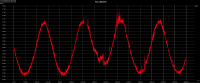
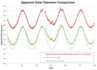
OK, more fun with the tau images. For each of the tau images I binarized the images (fixed threshold @127) and counted the white pixels, finally, from the area I computed teh diameter. The attached plot shows the variation of Sun diameter vs Sol. Pretty crude and it shows, but it gives an idea of the variation.
|
Paolo
Posted by: Stu Jul 6 2012, 12:11 AM
Thanks for all your hard work on that Paolo, it's much appreciated. Very interesting and informative too.
Posted by: RoverDriver Jul 6 2012, 12:14 AM
You are welcome. 5 min of scripting between MSL simulations ;-)
Paolo
Posted by: fredk Jul 6 2012, 12:19 AM
That's extremely cool - a beautiful sinusoid from such a simple idea.
The obvious question: what happened at the aphelion around sol 1600? That minimum is anomalously higher than all the others. Something different about the exposures perhaps?
Posted by: brellis Jul 6 2012, 12:29 AM
I assume some of the spikes reflect dust-clearing wind events. Are there 'windy seasons' at Meridiani?
edit: oops I thought Paolo's graph was dust-related. d'ohh!
Posted by: RoverDriver Jul 6 2012, 01:13 AM
The obvious question: what happened at the aphelion around sol 1600? That minimum is anomalously higher than all the others. Something different about the exposures perhaps?
The honest answer is: I don't know. It would not surprise me if the explanation involved dust accumulation on the PANCAM lens, I would need to take a look at the images. Also, keep in mind that I just applied a fixed threshold to all images, I did not attempt to compute the Sun area very well, it was a hack put together very, very quickly. Brellis: the way I computed the diameter is extremely crude and an error in a few pixels is very likely. This was obviously not meant to be a refined measurement, what I meant to show is that indeed you can see minor variations in the Sun diameter (and that there are no boring images from Mars).
Paolo
Posted by: RoverDriver Jul 6 2012, 01:15 AM
Are there 'windy seasons' at Meridiani?
...
Forgot to answer this question. Yes, there are cleaning event seasons, sometimes followed by dusty seasons. IIRC they are end of the (Martian) summer. If you look at the Tau plots you should be able to see them.
Paolo
Posted by: siravan Jul 6 2012, 01:21 AM
Very interesting graph. There is more information in this graph than seems at the first glance. For example, in principal, it is possible to calculate the Mars orbital eccentricity from the ratio of the largest to smallest diameter (let x be the ratio, e=(x-1)/(x+1) ). The value I'm getting is 0.063, which is 2/3 of the actual e=0.093. I suspect the discrepancy might be due to atmospheric effects of the apparent diameter.
Posted by: RoverDriver Jul 6 2012, 02:12 AM
Now that we have demonstrated that even the Pancam Tau can be interesting, how about all those Cal Target? Any ideas on what we can do with them (besides their intended use)?
Paolo
Posted by: siravan Jul 6 2012, 03:12 AM
One possibility is to plot the average pixel value of a region on the top of each frame over the background (probably divided by the value of a part of the calibration target to correct for change in the ambient light). This way one gets a graph of the local "soil" brightness/darkness over the course of 8 years.
Posted by: centsworth_II Jul 6 2012, 04:14 AM
http://www.marsroverblog.com/discuss-170792-the-stain.html
Posted by: fredk Jul 6 2012, 05:00 AM
Measure the brightness within the shadow of the gnomon and just outside, and take the ratio. The higher the atmospheric tau is, the greater the brightness of the sky relative to that of the sun. Therefore, that shadow ratio should be correlated with tau. In principle you could do a calibration using the real tau measurements to convert the ratio into an estimate of tau.
Of course this would be much more work than 5 minutes of scripting! I can't imagine automating this. This is a job for a summer student! In practice, shadows are brighter (less distinct) when the sun is lower, so you'd want to use just the pics with the sun around some fixed altitude.
This is actually an effect that's pretty easy to notice if you pay attention to shadows over time. A sudden brightening of the shadows is a sure sign of a jump in tau.
Posted by: ElkGroveDan Jul 6 2012, 05:51 AM
Touché I retract my previous post.
Posted by: ngunn Jul 6 2012, 09:30 AM
Fantastic - what fun!! Thanks again Paolo.
Posted by: Deimos Jul 6 2012, 02:12 PM
Have fun! (Pulling the tau data would screen out the transits based on both seq ID and filter-- R8 vs. L8).
Posted by: Deimos Jul 6 2012, 02:18 PM
Most likely. A DN brightness threshold would be sensitive to exposures. The images are manual exposures, adjusted episodically to account for dust on optics and seasonal expectation of atmospheric dust load. High tau or high window dust -- relative to expectations at the last exposure update -- would make the solar brightness smaller, which would propagate to a low radius. And, of course, vice versa.
Posted by: Greenish Jul 6 2012, 03:33 PM
Well, since this is an obscure side topic I figured it would be a decent place for my first UMSF contribution. See attached chart.
I used the JPL HORIZONS web interface to get the predicted apparent solar diameter as seen from Mars and plotted it for sols 1-3000. Using a value of .28 mrad/pixel (=57.75 arcsec/pixel) for Pancam which appeared in several sources I googled, I aligned this with Paolo's chart. The alignment was done manually so no guarantees it's precise.

|
As I would expect from some dust etc. the apparent diameter is a bit larger than the purely geometric prediction. Interestingly as siravan mentioned the magnitude of the variation is less than the prediction.
Comments/criticism/corrections welcome. This is not my field of expertise.
Posted by: fredk Jul 6 2012, 05:29 PM
Very nice comparison, Greenish. I've confirmed your numbers, but I've seen 0.27 mrad/px which improves the agreement a bit. That leaves 2 pixels excess in Paolo's measurements, ie one pixel on each limb, which sounds reasonable considering exposure/psf/binarization effects.
Paolo's results clearly show that Mars periodically gets closer and farther from the sun, like Kepler's 1st law predicts. But they also show more. If you look closely, the minima are broader than the maxima. This is because Mars moves more slowly (and so spends more time) near aphelion than near perihelion, according to Kepler's 2nd law.
You can see this clearly in Greenish's predicted curve. This gif flips back and forth from the normal curve to the curve reflected vertically. This makes it easy to see the asymmetry in width between the peaks and the troughs:

|
Repeating with Paolo's measurements, again you can see that the minima are broader than the maxima:

|
So we find evidence for two of Kepler's laws, all from just 5 minutes of scripting!
Posted by: RoverDriver Jul 6 2012, 05:37 PM
This thread has also proved something else: how great you guys are! I knew it already but this is further proof of it (just in case there was any doubt). Thank you all.
Paolo
Posted by: ElkGroveDan Jul 6 2012, 07:49 PM
Paolo was the graph created with all 4779 images from your first gif? or just the 747 separated by one sol?
Posted by: RoverDriver Jul 6 2012, 07:58 PM
The latter animation includes only 747 images, the plot includes all 4779 data points.
Paolo
Posted by: Greenish Jul 6 2012, 08:56 PM
Paolo sent me the actual data (thanks!) so I re-did the plot. Thankfully, it looks the same.
The green points show what happens iif you subtract 3 pixels from the observed diameter: the maxima line up. (It looks similar if you use .27 mrad/px and subtract 2 pixels). I don't know if that's legit but it illustrates fredk's note above.
|
Posted by: Stu Jul 7 2012, 12:47 AM
Surface close up...

|
Posted by: Stu Jul 7 2012, 12:50 AM
Gorgeous detail visible on the Faraway Hills now, too...
|
|
Posted by: Astro0 Jul 7 2012, 01:59 AM
I was working on those exact same images when you posted them.
Especially like the one, maybe two, tiny natural arches.

|
Posted by: Matt Lenda Jul 7 2012, 02:35 PM
|
|
o_O
Is that vertically stretched at all?
-m
Posted by: fredk Jul 7 2012, 02:51 PM
It looks like a straight zoom, Matt.
Astro - nice catch! It's too bad but we're just barely missing R2 coverage of that feature. Here's the best anaglyph I could come up with, combining L2 and navcam R0:

|
Not quite enough detail to confirm an arch, I'd say.
Posted by: Stu Jul 7 2012, 03:26 PM
No, that's a straight crop of a panoramic mosaic, Matt.
Have a quiet word in someone's ear and suggest that now would be a **really** good time to take a full super-res panorama of the farside of Endeavour...that would be glorious...
Posted by: RoverDriver Jul 7 2012, 04:33 PM
I'm not sure, but I think we are still flash volume limited but the area where we are moving to should still provide quite a view.
Paolo
Posted by: PaulM Jul 7 2012, 07:34 PM
The full Greenly Pan was released by NASA on the 5th July:
http://marsrovers.nasa.gov/newsroom/pressreleases/20120705a.html
The pan currently has top billing on the Daily Mail's web site:
http://www.dailymail.co.uk/sciencetech/article-2170196/The-best-thing-NASAs-Opportunity-Rover-captures-360-panorama-base-long-Martian-winter.html
The deck pan has been flawlessly merged with the Greenly Pan despite the two pans being taken a few cm apart.
Posted by: Stu Jul 8 2012, 10:31 AM
Just... beautiful... (the place and the geology, not my picture! )

|
Edit: actually, I think I like this version more... http://roadtoendeavour.files.wordpress.com/2012/07/pano-8-july-2012d.jpg ?
Posted by: Stu Jul 8 2012, 10:33 AM
...and another nice chunka gypsum...

|
Posted by: brellis Jul 8 2012, 04:46 PM
Stu, in that gorgeous pic from your Post 270 -- fascinating that some of the layered rock is vertical, and some looks smeared or shaved horizontally.
Posted by: Stu Jul 8 2012, 10:19 PM
Paolo
Yep..
http://qt.exploratorium.edu/mars/opportunity/micro_imager/2012-07-08/1M395053860EFFBRQ2P2935M2M1
Posted by: Phil Stooke Jul 9 2012, 04:22 PM
Astro0, I'm going to go out on a limb here and say I don't think your features are arches. This looks like the famous case of O'Neill's Bridge on the Moon. An arcing shadow with an illuminated lump in front of it looks very much like an arch with illuminated terrain behind it. I think the arch shadow should be more forward in the image than it is if it were real.
Phil
Posted by: algorimancer Jul 9 2012, 05:09 PM
A bit late to the party (I was on vacation last week), but some time back I realized that, if you use pancam photogrammetry to measure the various linear distances among the corners of the square aluminum base plate of the calibration target, you can use these distances as a means of estimating the changes in temperature of the plate. I even did a quick validation check of this using AlgorimancerPG, but decided that it would take more time than I was willing to spend to do anything of interest with this notion, though it was clear that the changes in dimension predicted due to fairly small changes in temperature were quite accessible with this method, and the fact that you can measure between combinations of corners provides a foundation for some good statistics on the estimates. Is the temperature of the base plate of any real interest to anyone? Considering that it is affected by solar irradiation effects moderated by dust?
Posted by: RoverDriver Jul 9 2012, 06:45 PM
That's a good one. I would have to look at what is the actual resolution you can get from the PANCAM. The pointing of the PMA is not very accurate. For example when we do RAT activities we point the PMA to the turret but we do not repoint until all the RAT activity is complete because when we blink the images we do not want to be distracted by the pointing inaccuracies. Another source of error would be the changing sistance from the CalTarget plate and the PMA due to thermal dilation/contraction. Recovering the footprint of the caltarget automatically would be quite difficult but not impossible. For starters one could analyze a few selected images taken early in the morning or late in the afternoon and compare the plate size to images taken at noon. I'm going to leave this exercise to the reader ;-)
Paolo
Posted by: djellison Jul 9 2012, 06:59 PM
The Sundial base is 8cm across, and about 215 pixels across at its nearest side. Roughly 0.37mm/pixel - but at this range it's out of focus - the PSF is probably a couple of pixels across.
Aluminium's thermal expansion is about .023mm/meter per degree K. So 0.00184 mm / degree.
Given a 100 degree change - you might see something like 0.2mm change
I would doubt, very much, that it would be visible.
Posted by: jamescanvin Jul 9 2012, 08:05 PM
Slipped out of the habit of doing these again, especially seeing how good and how quick Stu is these days.
Need to get back to it ready for MSL, so her is my take of Veladero:
http://www.nivnac.co.uk/mer/index.php/b3003
Posted by: algorimancer Jul 9 2012, 08:59 PM
The trick here is that you can take advantage of measurements along each edge and diagonal of the base, then do pairwise comparisons between these measurements on different dates. So it is not so critical to observe the change on a single edge -- let's say you measure the 4 edge lengths and the 2 diagonals, then scale the diagonal lengths to match the edges (divide by sqrt(2)), so you've essentially got 6 samples of the edge length of this square base on that occasion. Do the same thing on a different occasion. Perform a paired t-test by pairing the equivalent measurements from the 2 occasions. From this you've got a mean change in the edge length, and you can get an associated confidence interval and p-value. The "noise" in the measurements is essentially averaged out, and since you can quantify the noise (since you can get a standard deviation) you can do some good statistics; handily, this sort of measurement error should be very "normal".
Paolo, the pointing of the pancam need only be such that the target is included in both L & R images taken on that occasion, the exact orientation of the pancam is not critical, we're depending on the camera model to identify the xyz coords of each vertex on the plate, then finding the 3D distances between those vertices. Where this gets potentially complicated is if you stop to consider whether the change in temperature also changes the camera model enough to be a problem.
My back-of-envelope estimates at the time I first looked at this suggest that a 100 degree C change in temperature should be easily measurable, and likely even a 20 degree change. Below that it looked "iffy".
Posted by: Phil Stooke Jul 9 2012, 09:48 PM
Sharp edges can be located to significantly better than a pixel by appropriate modelling, as is routinely done in astronomy by limb-fitting routines. I don't know the details but they must be readily available. Measuring along the edge, you would be taking advantage of lots of pixels, not just the end points of an edge or diagonal. Every pixel on the edge would contribute to fixing the position.
Phil
Posted by: Astro0 Jul 10 2012, 12:02 AM
Phil
One of the reasons I was going with a natural arch was because of the rock feature immediately to the right in that pan of Stu's.
The next rock has hollows in it. So assuming that the 'arch rock' is a piece of that same rock type, then the arches may well be there.
I guess unless they take something higher res and perhaps a different angle (unlikely), we'll never know.
Maybe we'll luck out and get another shot of the area under different lighting conditions.
But it is interesting to look at this area and try to interpret what we are seeing without having the benefit of actually being there.
That's the fun part!
Posted by: CosmicRocker Jul 10 2012, 05:32 AM
If you look at it in a false color composite, it seems clear that we are seeing the "blue" soil through two holes in the rock.

|
Posted by: Oersted Jul 10 2012, 12:27 PM
Very convincing Cosmicrocker: definitely looks like arches to me. The rightmost arch even seems to be composed partially of vein material, doesn't it?
Posted by: Phil Stooke Jul 10 2012, 01:12 PM
The one on the left is more convincing, certainly. I might believe in that one, eventually! The one on the right looks like it's casting its shadow backwards if it's an arch. I don't find that one very convincing.
Phil
Posted by: algorimancer Jul 10 2012, 01:51 PM
Quite true, and I have seen this used elsewhere in photogrammetry, so in principal the dimensions of the base plate can be determined rather precisely, and its changes in temperature estimated likewise. Estimating temperature changes is a neat trick -- would this be of value in the absence of an external thermometer on the MER rovers, or would it just be a neat thing to do?
Incidentally, if anyone is curious to try this using distances between the corners of the plate (as described in an earlier post) with the AlgorimancerPG application, one difficulty I encountered when I initially looked into this (December 2010) was that many of the images of the calibration target were sub-frame images, rather than the full-frame 1024x1024 images required by the software in its current incarnation. If this is important, the software could be modified to handle sub-frame images in conjunction with the pancam tracking database.
This brings up another issue -- in the absence of an available camera model for MSL, there will likely be a lengthy post-landing delay in revising AlgorimancerPG for MSL.
Posted by: fredk Jul 10 2012, 03:24 PM
I agree with Phil's original claim, that the light patch (white arrow in pic below) is the top of a pebble sitting in front of the alleged arch, rather than the ground behind viewed through a hole. The pebble's flat top is tilted towards us.
My reasons: the shadow of the supposed arch (grey arrow) looks too narrow, and seems to have a break in it (black arrow). Also, we're looking down at quite a steep angle at this rock. So the bottom floor of the arch would have to be sloping coincidentally at least at the same angle so we can't see the floor of the arch. Or the floor would have to be extremely narrow, front to back, which seems unlikely.
I've taken the average of L5 and L7 frames to reduce noise (adding L2 doesn't help). This allows us (barely!) to zoom to 200%:

|
Once I picture the light patch as a pebble in front of the "arch", I can't believe it's an arch. The thin shadow now makes sense.
Posted by: fredk Jul 11 2012, 04:22 AM
Another drive NE tosol - I think we're now sitting in the "mininotch" feature. This looks like its mouth:
http://qt.exploratorium.edu/mars/opportunity/navcam/2012-07-10/1N395227680EFFBRTZP1977L0M1.JPG?sol3008
Very nice shadow shot:
http://qt.exploratorium.edu/mars/opportunity/rear_hazcam/2012-07-10/1R395232891EFFBRTZP1312R0M1.JPG?sol3008
Posted by: marsophile Jul 11 2012, 05:57 AM
http://qt.exploratorium.edu/mars/opportunity/navcam/2012-07-10/1N395227680EFFBRTZP1977L0M1.JPG?sol3008
Looks like part of the ground may be sinking in that area.
Posted by: fredk Jul 11 2012, 03:00 PM
Anaglyph of the glorious mess beside us now:

|
Posted by: DFinfrock Jul 11 2012, 11:00 PM
http://qt.exploratorium.edu/mars/opportunity/navcam/2012-07-10/1N395227680EFFBRTZP1977L0M1.JPG?sol3008
Mini notch? Or mini graben? What would cause such a slumping on such a small scale as this?
Posted by: RoverDriver Jul 11 2012, 11:12 PM
Just got word ODY is in safe mode again. They do not know what is the cause of the safe mode yet.
Paolo
Posted by: nprev Jul 12 2012, 12:27 AM
Drat.  Thanks for the update, Paolo.
Posted by: PDP8E Jul 12 2012, 01:15 AM
Hey DFinFrock ... that's what I thought as I saw that image, a minor fault graben !
Posted by: walfy Jul 12 2012, 03:41 AM
From sol 3008, inward slope of Cape York now more in view, as well as its angle of slope compared to distant horizon.
|
|
(Edit: I'm afraid I may have cropped it so the distant horizon is not exactly level. But maybe it's not level anyway, considering the massive craters just beyond the horizon and how the landscape may have been adjusted on a much larger scale?)
Posted by: CosmicRocker Jul 12 2012, 05:11 AM
It definitely looks like the mini-notch is bounded by a pair of parallel faults. A graben might make sense near a crater rim, but so also might a pair of normal faults, or perhaps even a horst. Since these faults are presumably billions of years old and the current topography is largely the result of differential erosion, the topography will not reveal the directions of fault movement.
It would be nice to get a full pancam panorama here and turn it into a polar projection, but maybe even a navcam panorama to polar would reveal something interesting. As of yet, a key navcam is still not down yet.
Posted by: dilo Jul 12 2012, 08:08 AM
http://qt.exploratorium.edu/mars/opportunity/rear_hazcam/2012-07-10/1R395232891EFFBRTZP1312R0M1.JPG?sol3008
Nice indeed, here below a colorized/unvignetted version:

|
Posted by: James Sorenson Jul 12 2012, 08:17 AM
My version of the Sol 3008 Horizon Pan.

|
Posted by: Tesheiner Jul 12 2012, 10:31 AM
And here's a polar view made from a navcam mosaic created with MMB "Export panorama" option. Unfortunately, there are still several images missing.

|
Posted by: Stu Jul 12 2012, 04:27 PM
While we wait for ODY to cme out of its latest sulk and start talking to us again, there's a fascinating - and very welcome - "Beginners Guide to the Geology of Endeavour" in an interview with MER's Dr Barbara Cohen, over on my blog now, if anyone wants a look...
http://roadtoendeavour.wordpress.com/2012/07/12/the-road-to-endeavour-interviews-dr-barbara-cohen
Posted by: Oersted Jul 12 2012, 08:11 PM
Thanks Stu and Dr. Cohen: I just improved my knowledge of Endeavour by about 1000%.
Powered by Invision Power Board (http://www.invisionboard.com)
© Invision Power Services (http://www.invisionpower.com)