MSL Curiosity Lands Safely in Gale Crater, Landing and Commissioning Activity Period 1A, sols 0-8 |

  |
MSL Curiosity Lands Safely in Gale Crater, Landing and Commissioning Activity Period 1A, sols 0-8 |
 Aug 7 2012, 07:14 AM Aug 7 2012, 07:14 AM
Post
#361
|
|
|
Junior Member  Group: Members Posts: 36 Joined: 14-July 06 Member No.: 972 |
I see some NavCam and MAHLI images on the JPL raw site.
The NavCam thumbnails show that it is alive and functioning, but still stowed. I am very excited to see the full NavCam panorama once the Remote Sensing Mast is deployed. |
 |
 
|
|
Aug 7 2012, 07:15 AM
Post
#362
|
|
|
Senior Member Group: Members Posts: 2079 Joined: 13-February 10 From: Ontario Member No.: 5221 |
moozoo:Those have all been answered before, all in the negative.
The heat shield, on the other hand, is another matter. I wonder if it turned inside out like Oppy's did. The engineers will want to know its performance for sure. As for exposure, the tungsten masses would have done a good job; heavy, falling very fast, and chemically pure. A big hole would be hard to not excavate. Just a matter of spotting them w/ MRO and seeing which is closest to MSL's future path. |
|
|
|
|
Aug 7 2012, 07:21 AM
Post
#363
|
|
 Member Group: Members Posts: 813 Joined: 8-February 04 From: Arabia Terra Member No.: 12 |
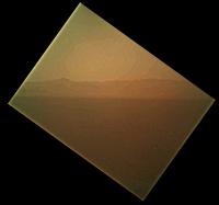
QUOTE (Eluchil @ Aug 7 2012, 05:14 PM)  I see some NavCam and MAHLI images on the JPL raw site. The MAHLI looks like it missed the crater rim and just shows the sky. I'm seeing horizon/rim of Gale, just very washed out. |
|
|
|
|
Aug 7 2012, 07:22 AM
Post
#364
|
|
|
Rover Driver Group: Members Posts: 1015 Joined: 4-March 04 Member No.: 47 |
Late at the party, but a big congratulations to the MSL team! Already we're seeing some mouthwatering pictures. Looking forward to a succesful mission

|
|
|
|
|
Aug 7 2012, 07:25 AM
Post
#365
|
|
|
Junior Member Group: Members Posts: 36 Joined: 14-July 06 Member No.: 972 |
QUOTE (SFJCody @ Aug 7 2012, 08:21 AM) I'm seeing horizon/rim of Gale, just very washed out. Yep. The processed version posted by JPL and linked by Explorer1 shows this clearly. The raws are tilted about 135 degrees. |
|
|
|
|
Aug 7 2012, 07:44 AM
Post
#366
|
||
 Member Group: Members Posts: 691 Joined: 21-December 07 From: Clatskanie, Oregon Member No.: 3988 |
Looks like there is alot of dust on the cover of MAHLI. You can see some rocks...After some sharpening and brightness adjustments.
|
|
|
|
|
|
|
Aug 7 2012, 08:11 AM
Post
#367
|
|
|
Senior Member Group: Moderator Posts: 4279 Joined: 19-April 05 From: .br at .es Member No.: 253 |
QUOTE (Pando @ Aug 7 2012, 06:56 AM) Could this be the descent stage? I doubt it's the shadow, but the metal components might reflect light... Don't think so. It looks like a dust grain on the lens. |
|
|
|
|
Aug 7 2012, 08:39 AM
Post
#368
|
|
 Senior Member Group: Admin Posts: 3108 Joined: 21-December 05 From: Canberra, Australia Member No.: 615 |
 Ah, I remember back to the early days of the Forum when Spirit and Opportunity landed. Ah, I remember back to the early days of the Forum when Spirit and Opportunity landed.How we'd have so much fun just sharpening and contrasting images until the better quality images came along Takes me back to those good ol' days  Go Curiosity!! |
|
|
|
|
Aug 7 2012, 08:41 AM
Post
#369
|
|
|
Member Group: Members Posts: 282 Joined: 18-June 04 Member No.: 84 |
The NAVCAMs look quite dusty too
|
|
|
|
|
Aug 7 2012, 09:57 AM
Post
#370
|
||
 Senior Member Group: Moderator Posts: 2262 Joined: 9-February 04 From: Melbourne - Oz Member No.: 16 |
If I understood the talk at the last press conference then the stowed MAHLI image should fit into the scene something like this.
Attached thumbnail(s)
-------------------- |
|
|
|
|
|
|
Aug 7 2012, 10:13 AM
Post
#371
|
|
 Member Group: Members Posts: 276 Joined: 11-December 07 From: Dar es Salaam, Tanzania Member No.: 3978 |
QUOTE (jamescanvin @ Aug 7 2012, 12:57 PM) If I understood the talk at the last press conference then the stowed MAHLI image should fit into the scene something like this. Yeah it should be more or less there. The image caption says northwards. Brilliant image james! -------------------- |
|
|
|
|
Aug 7 2012, 10:51 AM
Post
#372
|
|
|
Newbie Group: Members Posts: 8 Joined: 17-October 10 Member No.: 5494 |
Where I can download detailed photos of landing place to load them to Google Earth? Maybe also some kmz file with location of Curiosity? Please.
|
|
|
|
|
Aug 7 2012, 11:24 AM
Post
#373
|
|
|
Junior Member Group: Members Posts: 36 Joined: 14-July 06 Member No.: 972 |
QUOTE (jmknapp @ Aug 7 2012, 12:02 PM) During the landing the EDL commentator said "we found a nice flat place, we're coming in ready for skycrane" (around 28:17 in this video). I wonder what he meant by that--that they just passively found a nice flat place? By what means did they get a measure of the flatness? My first thought was that he was referring to the landing ellipse as a whole, but in context it seems like it might be a translation of the immediately preceding chatter that the "altitude error" was 5.9 m. The low error reflects convergent altitude measurements, perhaps the IMU versus the radar that was talked about at one of the press conferences. |
|
|
|
|
Aug 7 2012, 11:36 AM
Post
#374
|
|
|
Junior Member Group: Members Posts: 29 Joined: 12-February 04 Member No.: 29 |
QUOTE (eoincampbell @ Aug 6 2012, 11:43 PM) But their shadows are cast on the backshell, as your wonderful 10x reveals, ...good enough for me I think the shadow is from the cone at the top of the backshell...... |
|
|
|
|
Aug 7 2012, 11:44 AM
Post
#375
|
|
|
Senior Member Group: Moderator Posts: 4279 Joined: 19-April 05 From: .br at .es Member No.: 253 |
QUOTE (gregson @ Aug 7 2012, 12:51 PM) Where I can download detailed photos of landing place to load them to Google Earth? Maybe also some kmz file with location of Curiosity? Please. The maps on Google Earth / Mars were updated (yesterday?) and currently cover the whole landing site at HiRISE resolution. Just open it in "mars mode" and zoom in at Gale Crater (or double click on Mars Gallery > Rovers and Landers > MSL Curiosity Rover) and you are there. |
|
|
|
|

|
Lo-Fi Version | Time is now: 19th April 2024 - 05:50 PM |
|
RULES AND GUIDELINES Please read the Forum Rules and Guidelines before posting. IMAGE COPYRIGHT |
OPINIONS AND MODERATION Opinions expressed on UnmannedSpaceflight.com are those of the individual posters and do not necessarily reflect the opinions of UnmannedSpaceflight.com or The Planetary Society. The all-volunteer UnmannedSpaceflight.com moderation team is wholly independent of The Planetary Society. The Planetary Society has no influence over decisions made by the UnmannedSpaceflight.com moderators. |
SUPPORT THE FORUM Unmannedspaceflight.com is funded by the Planetary Society. Please consider supporting our work and many other projects by donating to the Society or becoming a member. |
|