Titan's Equatorial Sand Seas |

  |
Titan's Equatorial Sand Seas |
 May 17 2007, 06:43 PM May 17 2007, 06:43 PM
Post
#31
|
|
 Senior Member  Group: Moderator Posts: 2785 Joined: 10-November 06 From: Pasadena, CA Member No.: 1345 |
Hmmm. Actually, there might be a way to see a recently erupted cryovolcano, at least in the dark basins:
If the hypothetical scenario presented above (post#21) is correct, anything that recently coughed up bright material (ammonium sulfate + other salts?) AFTER the last bright-material-dissolving event should be pretty obvious by VIMS and RADAR. In that case, we would expect a ISS and VIMS stain in the dark basin that would be larger than the RADAR signature. (Older features that had their bases scrubbed should have a smaller ISS and VIMS stain compared to RADAR.) Similarly, any impacts (or bulges that did not release bright salt material) in the dark brown basins after the last bright-material-dissolving event should be dark brown. They should not have any VIMS or ISS bright material on them compared to their surrounding area. Are there any craters visible only by RADAR that appear dark brown by VIMS? -Mike -------------------- Some higher resolution images available at my photostream: http://www.flickr.com/photos/31678681@N07/
|
 |
 
|
|
May 18 2007, 01:35 AM
Post
#32
|
||
 SewingMachine Group: Members Posts: 316 Joined: 27-September 05 From: Seattle Member No.: 510 |
Here's another work in progress. This makeover of the Adiri-Shangri-La regional view is cobbled together from the ISS basemap (10/06), the obligatory SAR swaths (T8/T13), raw frames from the 13 May T30 encounter, the nifty CICLOPS "looking ahead" Celestia mosaics, and a cannibalized 1/64th of Paul McCartney's birthday present. This is presented in the standard Exploitcorporations LLMF Equal-Area Projection ™, so plan on losing your blimp anywhere west of the center of the map.
-------------------- ...if you don't like my melody, i'll sing it in a major key, i'll sing it very happily. heavens! everybody's all aboard? let's take it back to that minor chord...
Exploitcorporations on Flickr (in progress) : https://www.flickr.com/photos/135024395@N07/ |
|
|
|
|
|
|
May 18 2007, 01:48 AM
Post
#33
|
|
|
Solar System Cartographer Group: Members Posts: 10145 Joined: 5-April 05 From: Canada Member No.: 227 |
Very nice. I hope you will do more of these.
Phil -------------------- ... because the Solar System ain't gonna map itself.
Also to be found posting similar content on https://mastodon.social/@PhilStooke NOTE: everything created by me which I post on UMSF is considered to be in the public domain (NOT CC, public domain) |
|
|
|
|
May 18 2007, 02:09 AM
Post
#34
|
|
|
Member Group: Members Posts: 813 Joined: 29-December 05 From: NE Oh, USA Member No.: 627 |
Exploitcorporations
All your work is breathtaking. Agree with Phil Stooke. Please continue!!!!! Just Wonderful!!!!! Craig |
|
|
|
|
May 18 2007, 03:28 PM
Post
#35
|
|
|
Senior Member Group: Moderator Posts: 2785 Joined: 10-November 06 From: Pasadena, CA Member No.: 1345 |
Wow!! That is totally awesome!!!
I just rearranged my office posters to make room for these!! Thank you for all your efforts to make these images!! -Mike -------------------- Some higher resolution images available at my photostream: http://www.flickr.com/photos/31678681@N07/
|
|
|
|
|
May 21 2007, 08:06 PM
Post
#36
|
||||||
|
Senior Member Group: Moderator Posts: 2785 Joined: 10-November 06 From: Pasadena, CA Member No.: 1345 |
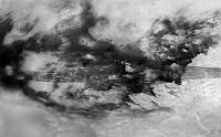
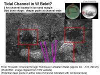
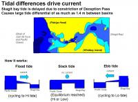
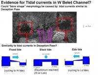
One of the dark channels from the T8 RADAR swath in western Belet (or eastern Senkyo) has a very curious appearance: at both ends of the of the 3 km channel there are RADAR dark smooth areas that is over 25 km2 in size. This symmetrical bone shaped appearance may have resulted from a tidal current flushing back and forth through the channel.
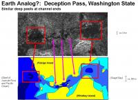
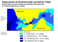
For comparision, I have compared the zoomed RADAR image of the Dark Channel in W Belet with a graphic showing marine topography of Deception Pass in Washington State (Deception Pass Coordinates: 48 degrees 24 23N; 122 degrees 5840 W). Deception Pass is located near the San Juan and Gulf Islands in Washington/British Columbia. This island group was formed through crustal extension and inundation to form an archipelago (sound familiar?). The entire the island group (especially the Gulf Islands of British Columbia) appear morphologically similar to areas on Titan. Deception Pass is notable for having an extremely strong current due to tidal effects. (A Seattle Times article on Deception Pass can be found here.) The way Deception Pass (and by analogy, the W Belet Dark Channel) develops ferocious tides is shown in the graphic below:
1. Tidal bulge reaches from the Pacific Ocean into the Strait of Juan de Fuca. 2. Sea level on the west side of the Pass rises faster than the sea level on the eastern (Skagit Bay) side of the Pass. 3. Height difference of 4.5 feet between the two sides causes eastward flow of 56,000 m3/s water through the channel (for comparison, the Mississippi River average flow is 17,600 m3/s). 4. As the sea levels on either side of the Pass eventually equilibrate, from both water flowing into Skagit Bay from through the Pass, and the longer route around Whidbey Island, the flow through the channel drops to near zero. 5. Tide bulge leaves Pacific 6. Sea level on west side of Pass drops faster than Skagit Bay can empty out. 7. New height differenential sets up, now current flows west (Skagit BayPacific) through Pass (Ebb tide cycling to Lo). 8. Skagit bay sea level drops, sea level differential drops to zero, flow through channel drops to near zero. In the Google Earth image you can actually tell which way the current is flowing when the Google Earth image was taken (Hint: Flood tide into Skagit Bay). The deeper areas at the two entrances to the Pass are swept clean from the current. (The Skagit River dumps a huge amount of sediment into the bay, if the current did not sweep the sediment out to sea, all the topography on the Skagit bay side would become a mudflat, similar to the area at the extreme NE of the Deception Pass graphic). There are other tidal channels in the San Juan Islands that display almost the same pattern of bottom topography: a narrow channel with localized depressions (deeper areas) at both tide channel exits. (Examples include: San Juan Channel; Spieden Channel; Harney Channel; Upright Channel; and Thatcher Pass.) The Dark Channel in western Belet (or eastern Senkyo) is approximately 3 km wide. This is 6x wider than Deception Pass. Using the formula [Flow (m3/sec) = 0.46 X1.61 channel width (m) ^1.22] that was used for other channels on Titan, we arrive at a predicted flow of 13,000 m3/s for the W Belet Dark Channel.. Extrapolating from Deception Pass numbers (Pass width = 500 m), we instead arrive at an extrapolated flow of 336,000 m3/s for the W Belet Dark Channel. Either way, its pretty impressive. Given the relative size of the dark areas at the ends of the channel (>25 km2!), I would be inclined to favor the larger numbers. If this is a tidal channel on Titan, it tells us several very important things. 1. There was a large sea or ocean in this area. 2. The sea or ocean lasted long enough to experience several tide cycles (with a 14 day cycle?) 3. Large flow rates were set up through the tidal channel. 4. The basin on the W is approximately at the same level as the basin on the E (at least the high methane mark) (An alternate possibility to be considered is that the channel is bi-directional and resulted from a single/multiple flood events going from E to W, then later from W to E.) If the deposition sequence put forward in post #21 is correct, we would expect that this channel should appear dark by ISS. I would expect that during the time the channel was inundated, tidal currents would have swept the Dark Channel clear of loose sediments. So this area may be relatively clear of ice sands and windblown dune sands compared to other areas in the Equatorial Dune Seas. If the channel bottom can be resolved by VIMS, the channel itself may be very interesting it may give us a glimpse into the bottom substrate that exists under the dune seas. Im hoping this area gets observed during the upcoming May 31 pass. I wonder if other tidal channels can be found by further examination of RADAR or VIMS images of Titans surface? Could we use these to infer the tidal pattern and current flows of past methane seas on Titan? (Astropaleohydrology?) -Mike -------------------- Some higher resolution images available at my photostream: http://www.flickr.com/photos/31678681@N07/
|
|||||
|
|
|
|||||
|
May 21 2007, 08:19 PM
Post
#37
|
|
 Dublin Correspondent Group: Admin Posts: 1799 Joined: 28-March 05 From: Celbridge, Ireland Member No.: 220 |
Surely Titan's Saturn synchronous orbit would inhibit tides ?
|
|
|
|
|
May 21 2007, 08:34 PM
Post
#38
|
|
|
Senior Member Group: Moderator Posts: 2785 Joined: 10-November 06 From: Pasadena, CA Member No.: 1345 |
QUOTE (helvick @ May 21 2007, 04:19 PM)  Surely Titan's Saturn synchronous orbit would inhibit tides ? I woulda thought so, too. But Tokano et al. invoke Titan's orbital eccentricity around Saturn as causing tidal winds on Titan. (Tokano, T; Neubauer, F. M. Icarus, 2002, 158 499-515. "Tidal winds on Titan caused by Saturn." Abstract available here) Their paper is discussing tidal winds in the atmosphere, but their arguments (and diagrams) would also seem to extend to large bodies of fluids on Titan's surface. -Mike -------------------- Some higher resolution images available at my photostream: http://www.flickr.com/photos/31678681@N07/
|
|
|
|
|
May 22 2007, 01:04 AM
Post
#39
|
|
 Senior Member Group: Members Posts: 1887 Joined: 20-November 04 From: Iowa Member No.: 110 |
I remember reading a paper before Cassini reached Saturn that claimed Titan couldn't have oceans and continents because the tides would produce enough erosion to eventuallly wear down the continents until they were below sea level.
|
|
|
|
|
May 22 2007, 01:42 AM
Post
#40
|
|
 Member Group: Members Posts: 723 Joined: 13-June 04 Member No.: 82 |
If Titan had global oceans on its surface, its tides would be enormous. Saturn's gravity well is far deeper than Luna's, and the eccentricity of Titan's orbit would be sufficient to induce tides measured in hundreds of metres. I worked through the calculation in an earlier post a couple of years ago, and came up with a result of about 150m.
(the tides are not caused by rotation within the tidally influencing body's gravity well, but by the local gravity differential across the diameter of Titan varying in strength due to the eccentricity of Titan's orbit) Since there is no global surface ocean on Titan, the tides would be proportionately smaller. I have to imagine that even such relatively small seas as we do see must have a tidal range of several metres, depending on the differential distance to Saturn between the closest and farthest points of the sea surface. At a first estimate, each 100km difference in distance to Saturn between the closest-to-Saturn and farthest-from-Saturn points of a single sea on Titan should produce about 3m of tidal range at those extremities. This tide would take the form of a 'slosh' with a period of roughly 15 days, with the sea levels on the sub-Saturn hemisphere reaching a maximum at the point closest to Saturn, and minimum at the point farthest from Saturn, when Titan is closest to Saturn, and the opposite pattern -- the sea levels at a minimum at the point closest to Saturn, and maximum at the point farthest from Saturn -- when Titan is farthest from Saturn. The shoreline midway between these two points should have little or no tidal range. Seas on the anti-Saturn hemisphere would have the opposite tidal pattern. Of course, local seabottom topography would have a big effect on tidal ranges too. Bill |
|
|
|
| Guest_AlexBlackwell_* |
May 22 2007, 01:44 AM
Post
#41
|
|
Guests |
QUOTE (alan @ May 21 2007, 03:04 PM) I remember reading a paper before Cassini reached Saturn that claimed Titan couldn't have oceans and continents because the tides would produce enough erosion to eventuallly wear down the continents until they were below sea level. You're probably referring to one of the two following papers: The tide in the seas of Titan Carl Sagan and Stanley F. Dermott Nature 300, 731-733 (1982). Abstract Tidal effects of disconnected hydrocarbon seas on Titan Stanley F. Dermott and Carl Sagan Nature 374, 238-240 (1995). Abstract |
|
|
|
|
May 22 2007, 09:28 AM
Post
#42
|
|
|
Senior Member Group: Members Posts: 3516 Joined: 4-November 05 From: North Wales Member No.: 542 |
We have a beautiful example of a tidal channel here in North Wales - the Menai Strait:
http://biology.bangor.ac.uk/research/wetla...es/image032.jpg Tidal range is up to 10m at one end and about half as much at the other. The phase difference is about one hour beween the two ends. Currents reach 8 knots. there are several deep spots including one near the NE end. |
|
|
|
|
May 22 2007, 12:17 PM
Post
#43
|
||
|
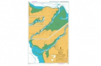
Senior Member Group: Members Posts: 3516 Joined: 4-November 05 From: North Wales Member No.: 542 |
Menai Strait chart attached:
Note that this is quite a young feature - it has probably widened and deepened considerably even since Roman times. I guess the same could be true for the Titan feature, so you might only need a (relatively) brief wet episode to produce it. |
|
|
|
|
|
|
May 22 2007, 02:24 PM
Post
#44
|
|
|
Senior Member Group: Moderator Posts: 2785 Joined: 10-November 06 From: Pasadena, CA Member No.: 1345 |
(I sooooo totally could not resist this...)
Further support for the similarity between Titan's archipeligos and the San Juan Islands of the Pacific Northwest: "gunkholing!". -Mike 
-------------------- Some higher resolution images available at my photostream: http://www.flickr.com/photos/31678681@N07/
|
|
|
|
|
May 22 2007, 04:33 PM
Post
#45
|
|
|
Senior Member Group: Members Posts: 3516 Joined: 4-November 05 From: North Wales Member No.: 542 |
If we are saying that the equatorial basins once contained liquid then presumably tides could have caused much larger scale erosion features than just that small winding channel in Western Belet. In fact it could have been a major factor shaping the morphology of the basins, particularly their margins. Is this what you have in mind, Juramike? That could mean that quite a lot of the streaky features that we have been thinking about in terms of dunes and prevailing wind patterns are really tidal erosion features merely exploited and rendered more visible (like a fingerprint) by a 'dusting' of dune material. Some of the funny directions might make more sense that way. I have never been entirely happy about the wind patterns on Titan being redirected in major ways by what is really quite modest topography, but liquid would be another matter.
|
|
|
|
|

|
Lo-Fi Version | Time is now: 18th April 2024 - 08:20 AM |
|
RULES AND GUIDELINES Please read the Forum Rules and Guidelines before posting. IMAGE COPYRIGHT |
OPINIONS AND MODERATION Opinions expressed on UnmannedSpaceflight.com are those of the individual posters and do not necessarily reflect the opinions of UnmannedSpaceflight.com or The Planetary Society. The all-volunteer UnmannedSpaceflight.com moderation team is wholly independent of The Planetary Society. The Planetary Society has no influence over decisions made by the UnmannedSpaceflight.com moderators. |
SUPPORT THE FORUM Unmannedspaceflight.com is funded by the Planetary Society. Please consider supporting our work and many other projects by donating to the Society or becoming a member. |
|