USGS Cloud Processing: strange results |

  |
USGS Cloud Processing: strange results |
 Apr 2 2015, 09:37 PM Apr 2 2015, 09:37 PM
Post
#1
|
|
 Newbie  Group: Members Posts: 14 Joined: 6-April 11 From: Cologne, Germany Member No.: 5951 |
Hi(gh)!
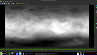
A new attempt at getting a simple cylindrical elevation bitmap of Vesta suitable for generating a mesh2 with POV-Ray... Whenever I try the USGS cloud processing of file Vesta_Dawn_HAMO_DTM_DLR_Global_48ppd.cub, I only get a ridiculously small zip file (only a few kilobytes!) containing either a strange XML description or a tiny little bitmap about 10 by 5 pixels... what do I wrong? I first click the blue "Process button", then log in, then choose options as following: Name or Label/Job Name: Dawn HAMO DTM Global 93mp: Apr 2, 2015 Name or Label/Job Description: PNG conversion of Dawn HAMO DTM of Vesta Image Options/Single Band Image: yes Image Options/Output Resolution (meters/pixel): 92.72061651 (default) Projection/Projection: Input Projection Projection/Extents/Max Latitude: 90 Projection/Extents/Min Longitude: 0 Projection/Extents/Max Longitude: 360 Projection/Extents/Min Latitude: -90 Download File Format/PNG, 8 bit (for the time being - later on I would also try out GEOTiff) Download File Format/Percent Stretch/Minimum: 0 Download File Format/Percent Stretch/Maximum: 100 Download File Format/Graticule, Grid Lines: No Grid Then I click on the blue "Add Job" button and wait about 5 to 10 minutes... ...this time (!) it almost worked well (possibly because I chose "Input Projection" rather than "Simple Cylindrical"), I in fact got a zip file of about 6.5 MB, containing a huge greyscale PNG of 17280 bx 8641 pixels... but... ...right through the center, from pole to pole runs a white gap, 17 to 18 pixels wide. As fixing this manually would be a no-go, I ask you now what I can do to get rid of this... could it be because of the non-default stretching? See you in Khyberspace! Yadgar |
 |
 
|
|
Apr 3 2015, 07:30 PM
Post
#2
|
|
|
Newbie Group: Members Posts: 3 Joined: 27-February 08 Member No.: 4059 |
Yadgar,
We just happened to notice this post. Please also feel free to send us an email to alert us of a potential issue. Our support email for POW and MAP2 is "astroweb at usgs.gov". Looking at your job, we realized we had an incorrect radius set for Vesta. This value is within our internal database (not the original image), so that we can generate products using the latest recommended IAU-approved radius values. The problem was simply that the radius was defined in kilometers when it should have been set in meters. Which is why your images were coming out so tiny. We updated the radius in our database to meters and re-ran a new Vesta job. It appears to be in good working order now. Here is the test run using the corrected radius value (8bit PNG of the original DEM): http://astrocloud.wr.usgs.gov/index.php?vi...8822b75ff5258de Note these are temporary files and will be deleted in a couple weeks. But feel free to run the job over yourself. In the job parameters below you can see what I set. Regards, Trent CODE <OutputOptions>
<OutputMapping> <Target> <TargetName>VESTA</TargetName> <EquatorialRadius>255000</EquatorialRadius> <PolarRadius>255000</PolarRadius> </Target> <Projection> <ProjName>INPUT</ProjName> </Projection> </OutputMapping> <OutputGeometry> <extents> <MaxLatitude>90</MaxLatitude> <MinLatitude>-90</MinLatitude> <MaxLongitude>180</MaxLongitude> <MinLongitude>-180</MinLongitude> </extents> </OutputGeometry> <OutputResolution>92.72061651</OutputResolution> <OutputType> <Format>PNG</Format> <BitType>unsignedbyte</BitType> </OutputType> <OutputGIS>true</OutputGIS> </OutputOptions> |
|
|
|
|
Apr 3 2015, 10:43 PM
Post
#3
|
|
|
Newbie Group: Members Posts: 14 Joined: 6-April 11 From: Cologne, Germany Member No.: 5951 |
Hi(gh)!
Meanwhile, I managed to generate and download a GeoTIFF file from Dawn's Vesta HAMO DTM .cub file (while I also started to manually fill in the white vertical gap in the 8bit PNG version of these data - but it's cumbersome work)... but as I tried to display this resulting file in 3DEM in order to generate an ASCII elevation matrix (which in turn would be processible by POV-Ray), I only got a "File Error". What software to fulfil this task would you recommend instead? See you in Khyberspace! Yadgar |
|
|
|
|
Apr 3 2015, 11:07 PM
Post
#4
|
|
|
Member Group: Members Posts: 910 Joined: 4-September 06 From: Boston Member No.: 1102 |
Hi Yadgar,
Others more knowledgable will have to help you find the best program. Unmannedspaceflight threads usually go for tens to hundred to thousands of entries. So please don't start a new thread after one response to the last thread you started on same topic. ADMIN NOTE: Agreed. Two topics merged. Please do not unnecessarily start threads. -------------------- |
|
|
|
|
Apr 5 2015, 06:39 AM
Post
#5
|
||
|
Member Group: Members Posts: 890 Joined: 18-November 08 Member No.: 4489 |
Where did you get the file "Dawn_HAMO_DTM_DLR_Global_48ppd.cub"
i use this http://dawndata.igpp.ucla.edu/tw.jsp?secti...UDIA_2013_02_13 VEST64_DTM.raw from Qview after running "maplab" on it
this is 570 Meg cub file there is a cub file http://dawndata.igpp.ucla.edu/tw.jsp?secti...Ms/DLR_HAMO_DTM QUOTE What software to fulfil this task would you recommend instead? Blender 2.73a i then wrote a custom lbl file and used ValterVB's blender ad on http://wiki.blender.org/index.php/Extensio...SA_IMG_Importer you might want to read the last post on the Blender artists thread http://blenderartists.org/forum/showthread...06-25%29/page10 see my post on the "celestialmatters forum" http://forum.celestialmatters.org/viewtopi...p?f=4&t=682 i have a 8ppd resolution 3d mesh in obj format UV mapped 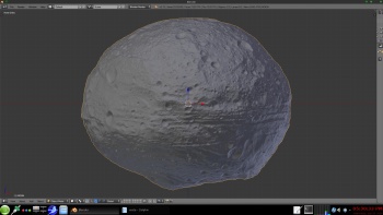 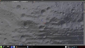 BUT it is 480 Meg what help do you need ? there are a few steps needed to import a dem into blender AS a 3d spherical object |
|
|
|
|
|
|

|
Lo-Fi Version | Time is now: 19th April 2024 - 04:35 AM |
|
RULES AND GUIDELINES Please read the Forum Rules and Guidelines before posting. IMAGE COPYRIGHT |
OPINIONS AND MODERATION Opinions expressed on UnmannedSpaceflight.com are those of the individual posters and do not necessarily reflect the opinions of UnmannedSpaceflight.com or The Planetary Society. The all-volunteer UnmannedSpaceflight.com moderation team is wholly independent of The Planetary Society. The Planetary Society has no influence over decisions made by the UnmannedSpaceflight.com moderators. |
SUPPORT THE FORUM Unmannedspaceflight.com is funded by the Planetary Society. Please consider supporting our work and many other projects by donating to the Society or becoming a member. |
|