Opportunity Route Map |

  |
Opportunity Route Map |
 Apr 1 2006, 08:04 AM Apr 1 2006, 08:04 AM
Post
#1171
|
||
|
Senior Member  Group: Moderator Posts: 4279 Joined: 19-April 05 From: .br at .es Member No.: 253 |
QUOTE (Burmese @ Mar 31 2006, 08:51 PM)  I wouldn't be surprised if, when they reach that large patch of exposed ground up ahead to the SSE, that they turn to the ESE and follow that sequence of exposed ground for a while. Only one line of slightly bigger dunes that can probably be dodged with a WNW jog for a day. As part of the planned activities for sol 778 (tomorrow) there is this navcam sequence: CODE 778 p0675.03 10 0 0 10 0 20 navcam_5x1_az_126_3_bpp It's a "post-drive" (yes, sol 778 is driving sol) 180º navcam mosaic centered at 126º. That heading is consistent with your proposed route. Let's see what happens on/after sol 778.
|
|
 |
 
|
|
|
Apr 1 2006, 08:10 AM
Post
#1172
|
|
 Senior Member Group: Members Posts: 2228 Joined: 1-December 04 From: Marble Falls, Texas, USA Member No.: 116 |
Yes. I am guessing a hard left is coming up soon. That's a highway not to be ignored.
-------------------- ...Tom
I'm not a Space Fan, I'm a Space Exploration Enthusiast. |
|
|
|
|
Apr 1 2006, 02:45 PM
Post
#1173
|
|
|
Senior Member Group: Members Posts: 2998 Joined: 30-October 04 Member No.: 105 |
I think they are going to keep on a step-stone path along the bedrock exposures. This is a course correction to avoid sandier areas (circled in green) that lie immediately ahead. We've been noticing that the ripples are looking "wilder". I think we'll still be pretty much bee-lined to arrive at the NW or NNW edge of the ejecta blanket.
An annotated adaption of Tesheiner's Route Map is attached. --Bill -------------------- |
|
|
|
|
Apr 2 2006, 08:43 AM
Post
#1174
|
|
|
Senior Member Group: Members Posts: 2228 Joined: 1-December 04 From: Marble Falls, Texas, USA Member No.: 116 |
I think we are all thinking of a similar route. The "hard left" turn I mentioned is the one in Bill's dark blue line, and the light blue path Tesheiner labels as "future path?," and the one originally described by Burmese when he suggested they would "turn to the ESE and follow that sequence of exposed ground for a while."
It seems a logical choice, since they do need to drive eastward to avoid the patches of apparently larger dunes to the south. It's a good place to cross cross a lot of smaller drifts and make eastward progress before resuming the southward trek using the troughs between the drifts. I think Tesheiner's line going all the way into the SE corner of his detailed map looks pretty good. From there, it's a straight shot to the south with lots of outcrop to drive on and fewer large drifts to have to cross. Antoniseb noted how straight this feature is, and wondered if it were some kind of ridge or fault line. I am curious about that, too. It's more or less aligned with several other lineaments in the region, and it also seems to fit with the concept that the bedding here appears to be dipping roughly to the south. That makes me suspect it is a layer of rock that is more resistant to erosion and coming to the surface here to form a ridge. -------------------- ...Tom
I'm not a Space Fan, I'm a Space Exploration Enthusiast. |
|
|
|
|
Apr 2 2006, 12:15 PM
Post
#1175
|
|
|
Senior Member Group: Members Posts: 2998 Joined: 30-October 04 Member No.: 105 |
This is a linear feature, but that is the trend here: at Erebus there were the Mogollon Rim and the Vermillion Cliffs as well as the unnamed straight features at Terra Nova. And Endurance has a polyagonal nature and there are the anatolia lineations. On our Moon, we've known for years that craters tens to have hexagonal rims, that is simply the nature of how rock breaks in impact (I disremember the exact explanation).
We need to keep a sharp eye out, though, since this is the stratigraphic high, also. --Bill -------------------- |
|
|
|
|
Apr 2 2006, 06:52 PM
Post
#1176
|
|
|
Member Group: Members Posts: 252 Joined: 27-April 05 Member No.: 365 |
Here is the view of the start of this east-west cut. Not terribly promising, but not bad, either.
http://qt.exploratorium.edu/mars/opportuni...J9P0675L0M1.JPG At some point they will have to cut East and I think if they do it now, they might get the added benefit of gaining a bit of higher ground earlier as I think the highest ground is just a bit east of Oppy. |
|
|
|
|
Apr 2 2006, 08:08 PM
Post
#1177
|
|
 Senior Member Group: Members Posts: 1229 Joined: 24-December 05 From: The blue one in between the yellow and red ones. Member No.: 618 |
I have to say that I think we may be being overly cautious about avoiding the dunes on the run to Victoria. Sure the Purgatory experience threw the fear of perdition into us, but I'm not convinced we have other Purgatory Dunes ahead waiting to snare us. There may be a few patches of 'darker' sand it would be prudent to skirt. I'm not suggesting throwing caution to the wind. But I think the 'average' sand depth is less south of Erebus than north - that's why so much bedrock shows through that the area is called "etched terrain". I have not yet seen a hazcam shot suggesting any dangerous digging-in of the wheels. I think we can follow a more-or-less direct route to Victoria's skirts, and I think that is what the drivers are doing. How easily we will be able to cross the 'skirts' to the crater edge is unclear at this point since we don't know its composition. Time will tell whether it's easy or difficult.

-------------------- My Grandpa goes to Mars every day and all I get are these lousy T-shirts!
|
|
|
|
|
Apr 2 2006, 08:25 PM
Post
#1178
|
|
|
Founder Group: Chairman Posts: 14432 Joined: 8-February 04 Member No.: 1 |
QUOTE (Shaka @ Apr 2 2006, 08:08 PM) Sure the Purgatory experience threw the fear of perdition into us, but I'm not convinced we have other Purgatory Dunes ahead waiting to snare us. We see bigger and more frequent dunes now than we did before hitting Purgatory - and lest we forget we had a near purgatory event on the north rim of erebus that was saved only by the rovers use of visidom. The rover has a good ammount of power. You balance the eagerness to get to victoria with the risk of getting stuck - and daily drives of 30, 40, 50m are more than adequate to get the job done without putting the vehicle at unnecessary risk. Doug |
|
|
|
|
Apr 2 2006, 09:03 PM
Post
#1179
|
||
|
Senior Member Group: Moderator Posts: 4279 Joined: 19-April 05 From: .br at .es Member No.: 253 |
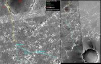
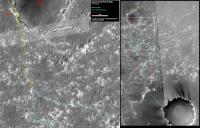
Here is the route map, updated after sol 778 drive.
I included a new "future path" going almost ESE starting on the next move. Pretty sure it won't be the selected one; Oppy will take a route somewhere inbetween these two proposals. 
|
|
|
|
|
|
|
Apr 2 2006, 09:49 PM
Post
#1180
|
|
|
Senior Member Group: Members Posts: 1229 Joined: 24-December 05 From: The blue one in between the yellow and red ones. Member No.: 618 |
QUOTE (djellison @ Apr 2 2006, 10:25 AM) We see bigger and more frequent dunes now than we did before hitting Purgatory - and lest we forget we had a near purgatory event on the north rim of erebus that was saved only by the rovers use of visidom. The rover has a good ammount of power. You balance the eagerness to get to victoria with the risk of getting stuck - and daily drives of 30, 40, 50m are more than adequate to get the job done without putting the vehicle at unnecessary risk. Doug I am not good at judging the size of objects in MER photographs (Spongebob's Mom was a particularly embarrassing example). If we are seeing bigger dunes now than we saw north of Purgatory, I am entirely unaware of it. I wish there was a running database of these kinds of statistics readily available to me. I don't have the training to do my own measurements. I was not in any way questioning the apparent driving philosophy of Oppy. I thought I was explaining it, by suggesting that some of the hypothetical tracks proposed by some UMSF members were more 'evasive' than the Rover drivers were using. I am impressed by the straightness of the rear hazcam photos. They don't appear to my unprofessional eye as highly evasive. -------------------- My Grandpa goes to Mars every day and all I get are these lousy T-shirts!
|
|
|
|
|
Apr 2 2006, 11:37 PM
Post
#1181
|
||
|
Member Group: Members Posts: 235 Joined: 2-August 05 Member No.: 451 |
QUOTE (Tesheiner @ Apr 2 2006, 03:03 PM) Here is the route map, updated after sol 778 drive. I included a new "future path" going almost ESE starting on the next move.
I'm glad to see the ESE path included for the moment, however I was surprised to see the path after the ESE leg not going SSSW, so as to follow the troughs of the dunes. The ESE path positions Opportunity well for a straight shot South with no dune hopping. |
|
|
|
|
|
|
Apr 3 2006, 04:47 AM
Post
#1182
|
|
|
Senior Member Group: Members Posts: 2228 Joined: 1-December 04 From: Marble Falls, Texas, USA Member No.: 116 |
Now that we can see it's entrance, that route doesn't look very promising, does it? But the first 70 meters or so was kind of 'iffy' to begin with. It seems pretty clear now that they will not take that route, since they barely looked in that direction and took no pancams that way. For the time being it looks like they will continue following the troughs, taking the nominal 165 degree heading for a while.
In the past they have mostly navigated through pretty large drift fields without much apparent trouble by using this technique, but there is a drift train coming up that appears to be the most significant one yet seen. I guess we'll see when we get there. It appeared to me that the purgatory incident occurred shortly after Opportunity climbed onto a less significant drift train. -------------------- ...Tom
I'm not a Space Fan, I'm a Space Exploration Enthusiast. |
|
|
|
|
Apr 3 2006, 06:37 AM
Post
#1183
|
|
|
Member Group: Members Posts: 178 Joined: 13-September 05 Member No.: 498 |
QUOTE (Tesheiner @ Apr 2 2006, 03:03 PM) I included a new "future path" going almost ESE starting on the next move. Pretty sure it won't be the selected one; Oppy will take a route somewhere inbetween these two proposals. The nearly-dead-south path looks most likely to me, with Oppy continuing to shoot the tubes and turn east on rock only when necessary. |
|
|
|
|
Apr 3 2006, 07:49 AM
Post
#1184
|
|
|
Senior Member Group: Members Posts: 2920 Joined: 14-February 06 From: Very close to the Pyrénées Mountains (France) Member No.: 682 |
I don't remember have seen this been discussed yet. Is there a relation between the orientation of the dunes where Oppy is now as compared to the orientation of the dunes inside Victoria ? The reason of the question is that I'm already thinking how to approch Victoria, and this could influence the entire trajectory of the drive from now on. I assume that the dark spots arround Victoria are were the sand has been blown by the wind i.e. less sand, i.e. easier place to approch, more likely better place to go if you need a blowing event to clean up you solar panel. This also will be a lower part in the crater rim, so you'll have a better view, etc etc so, LET'S GO to the dark spots.
-------------------- |
|
|
|
|
Apr 3 2006, 08:17 AM
Post
#1185
|
|
|
Senior Member Group: Moderator Posts: 4279 Joined: 19-April 05 From: .br at .es Member No.: 253 |
QUOTE (CosmicRocker @ Apr 3 2006, 06:47 AM) Now that we can see it's entrance, that route doesn't look very promising, does it? But the first 70 meters or so was kind of 'iffy' to begin with. It seems pretty clear now that they will not take that route, since they barely looked in that direction and took no pancams that way. For the time being it looks like they will continue following the troughs, taking the nominal 165 degree heading for a while. QUOTE (Joffan @ Apr 3 2006, 08:37 AM) The nearly-dead-south path looks most likely to me, with Oppy continuing to shoot the tubes and turn east on rock only when necessary. I wouldn't discard the ESE route yet; it wouldn't be the first time they drive outside the pancams fov. The fact they drove just to the beggining of this big outcrop and didn't traversed it 'till the end is an indication of the interest on this path. Time will tell... If the route is or not difficult, well, I'm remembering when the rover made that NW de-tour before approaching Olympia. These are navcams looking back, taken on sols 624, 625 and 626. Sol 624 (mid-drive): http://marsrovers.jpl.nasa.gov/gallery/all...BP1600L0M1.HTML Sol 624 (post-drive): http://marsrovers.jpl.nasa.gov/gallery/all...WP1655L0M1.HTML Sol 625 (mid-drive): http://marsrovers.jpl.nasa.gov/gallery/all...CP1600L0M1.HTML Sol 625 (post-drive): http://marsrovers.jpl.nasa.gov/gallery/all...UP1635L0M1.HTML Sol 626 (post-drive): http://marsrovers.jpl.nasa.gov/gallery/all...LP1635L0M1.HTML QUOTE (CosmicRocker @ Apr 3 2006, 06:47 AM) In the past they have mostly navigated through pretty large drift fields without much apparent trouble by using this technique, but there is a drift train coming up that appears to be the most significant one yet seen. I guess we'll see when we get there. It appeared to me that the purgatory incident occurred shortly after Opportunity climbed onto a less significant drift train. With visodom turned "on", the rover and the rover drivers are capable of outstanding things! 
|
|
|
|
|

|
Lo-Fi Version | Time is now: 26th April 2024 - 02:41 AM |
|
RULES AND GUIDELINES Please read the Forum Rules and Guidelines before posting. IMAGE COPYRIGHT |
OPINIONS AND MODERATION Opinions expressed on UnmannedSpaceflight.com are those of the individual posters and do not necessarily reflect the opinions of UnmannedSpaceflight.com or The Planetary Society. The all-volunteer UnmannedSpaceflight.com moderation team is wholly independent of The Planetary Society. The Planetary Society has no influence over decisions made by the UnmannedSpaceflight.com moderators. |
SUPPORT THE FORUM Unmannedspaceflight.com is funded by the Planetary Society. Please consider supporting our work and many other projects by donating to the Society or becoming a member. |
|