The Top of Vera Rubin Ridge Part 2, Site 67-73, sol 1944-2297, 24 Jan 2018-22 Jan 2019 |

  |
The Top of Vera Rubin Ridge Part 2, Site 67-73, sol 1944-2297, 24 Jan 2018-22 Jan 2019 |
 Nov 1 2018, 08:32 PM Nov 1 2018, 08:32 PM
Post
#541
|
|
 Member  Group: Members Posts: 809 Joined: 3-June 04 From: Brittany, France Member No.: 79 |
QUOTE (jccwrt @ Oct 29 2018, 09:30 PM)  I doubt 40 days is enough time to form a photooxidation rind (we were talking a year or two), but seeing the uniform color changes in that blink comparison brought the conversation back to mind. It could be a good opportunity to check! Don't you think that atmospheric dust deposition will hide the signal of surface oxidation? -------------------- |
 |
 
|
|
Nov 2 2018, 05:56 AM
Post
#542
|
||
 Senior Member Group: Members Posts: 2428 Joined: 30-January 13 From: Penang, Malaysia. Member No.: 6853 |
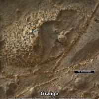
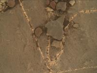
'Grange': Focus merge product, rotated sharpened and cropped estimated scale added (based on diameter of Inverness)
Raw file Link |
|
|
|
|
|
|
Nov 2 2018, 07:36 AM
Post
#543
|
|
|
Merciless Robot Group: Admin Posts: 8783 Joined: 8-December 05 From: Los Angeles Member No.: 602 |
Extraordinary. Anxious to hear the geologists' take on this.
To my unskilled eyes this looks less like a water-borne mineral intrusion than a melt of some sort enriched with whatever mineral those inclusions are made of. Looks like it once was very, very hot. -------------------- A few will take this knowledge and use this power of a dream realized as a force for change, an impetus for further discovery to make less ancient dreams real.
|
|
|
|
|
Nov 2 2018, 07:40 AM
Post
#544
|
|
 Member Group: Members Posts: 112 Joined: 20-August 12 From: Spain Member No.: 6597 |
QUOTE (nprev @ Nov 2 2018, 08:36 AM) Extraordinary. Anxious to hear the geologists' take on this. To my unskilled eyes this looks less like a water-borne mineral intrusion than a melt of some sort enriched with whatever mineral those inclusions are made of. Looks like it once was very, very hot. I think we are seeing a calcium sulphate with some metallic oxides (maybe iron or manganese) carried by the water that was reacting with the rock. But it is great to see this texture, I don't see it very often on Earth! |
|
|
|
|
Nov 2 2018, 10:02 AM
Post
#545
|
||
|
Senior Member Group: Members Posts: 2428 Joined: 30-January 13 From: Penang, Malaysia. Member No.: 6853 |
Looks like a short drive to the south on sol 2218 NLA. May have terminated early?
|
|
|
|
|
|
|
Nov 2 2018, 12:10 PM
Post
#546
|
|
|
Member Group: Admin Posts: 976 Joined: 29-September 06 From: Pasadena, CA - USA Member No.: 1200 |
From a cursory look, it seems all went well. About 5 meters worth. It was just a checkout drive, not a full drive.
Paolo -------------------- Disclaimer: all opinions, ideas and information included here are my own,and should not be intended to represent opinion or policy of my employer.
|
|
|
|
|
Nov 2 2018, 04:53 PM
Post
#547
|
|
|
Member Group: Members Posts: 306 Joined: 4-October 14 Member No.: 7273 |
QUOTE (neo56 @ Nov 1 2018, 03:32 PM) Don't you think that atmospheric dust deposition will hide the signal of surface oxidation? It'll certainly contribute to the observed passive spectra. However, we know the spectral signature of dust, so it might be possible to subtract out that signal to look for changes in the underlying rock if it doesn't totally coat the surface. AFAIK this is an ideal use case for VNIR spectral mixing models, since we have the rover nearby to help place constraints on some of the input parameters. I'm not sure that we're actually capable of detecting that signal, but it would be useful and interesting to look for. |
|
|
|
|
Nov 2 2018, 09:44 PM
Post
#548
|
|
|
Senior Member Group: Members Posts: 1043 Joined: 17-February 09 Member No.: 4605 |
The Curiosity Mission Update of 1st November identified "Grange" as a workspace target stating: "Grange" appears to be an area of bright calcium sulfate (commonly observed as veins cross-cutting bedrock encountered throughout the mission), but with small, dark inclusions that might have an interesting composition.
|
|
|
|
|
Nov 3 2018, 08:15 PM
Post
#549
|
||
|
Senior Member Group: Members Posts: 2822 Joined: 22-April 05 From: Ridderkerk, Netherlands Member No.: 353 |
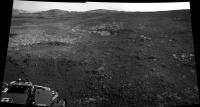
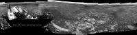
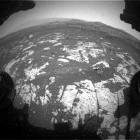
The Navcam L view on Sol 2218.
Jan van Driel
|
|
|
|
|
|
|
Nov 3 2018, 08:28 PM
Post
#550
|
||
|
Solar System Cartographer Group: Members Posts: 10154 Joined: 5-April 05 From: Canada Member No.: 227 |
Thanks, Jan. Here is a circular version of it. Compare the outcrops in the lower right area to the same areas in the previous circular panoramas to see how we moved.
Phil
-------------------- ... because the Solar System ain't gonna map itself.
Also to be found posting similar content on https://mastodon.social/@PhilStooke Maps for download (free PD: https://upload.wikimedia.org/wikipedia/comm...Cartography.pdf NOTE: everything created by me which I post on UMSF is considered to be in the public domain (NOT CC, public domain) |
|
|
|
|
|
|
Nov 4 2018, 05:02 AM
Post
#551
|
||
|
Senior Member Group: Members Posts: 2428 Joined: 30-January 13 From: Penang, Malaysia. Member No.: 6853 |
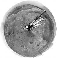
An unprocessed focus merged MAHLI product of what may be the target called 'Lossiemouth' the base images were acquired before the drive on sol 2218. It appears to show some of those erosion resistant dark inclusions in the bedrock and the mineral filled fractures similar to those that were seen in 'Grange'.
Interesting geology on this ridge for sure 
|
|
|
|
|
|
|
Nov 4 2018, 03:23 PM
Post
#552
|
|
 Member Group: Members Posts: 684 Joined: 24-July 15 Member No.: 7619 |
QUOTE (PaulH51 @ Nov 4 2018, 05:02 AM) An unprocessed focus merged MAHLI product of what may be the target called 'Lossiemouth' ... It appears to show some of those erosion resistant dark inclusions in the bedrock and the mineral filled fractures similar to those that were seen in 'Grange'. Interesting geology on this ridge for sure That appears to be some very fine-grained matrix rock, What "unit" are they calling this? We've heard of "mud stone" is there any prediction about aeolian dsposits; "dust stone"? Curious that similar rock seems to occur as oxidized red and reduced blue forms |
|
|
|
|
Nov 5 2018, 05:02 PM
Post
#553
|
|
|
Member Group: Members Posts: 306 Joined: 4-October 14 Member No.: 7273 |
QUOTE (HSchirmer @ Nov 4 2018, 09:23 AM) That appears to be some very fine-grained matrix rock, What "unit" are they calling this? We've heard of "mud stone" is there any prediction about aeolian dsposits; "dust stone"? Curious that similar rock seems to occur as oxidized red and reduced blue forms Curiosity is still in the Murray fm (upper Vera Rubin Ridge aka Jura mbr.) which is still a mudstone, but with odd highly oxidized patches. Last I heard (a few months ago), the interpretation was some odd diagenetic event taking place within this section of the Murray. As for dust stones, check out Nathan Bridges' work on Martian aeolian deposits ("Duststones on Mars" is a good primer). Given that we're still apparently in a lacustrine setting, I don't think dustfall would be a significant input or even distinguishable from the surrounding lake muds. That said, dust stone deposits might become more common further up the mountain, and my understanding is that the very top unit of Mt. Sharp (the "Upper Yardang Unit") is thought to be a dust stone of some sort. |
|
|
|
|
Nov 6 2018, 12:28 PM
Post
#554
|
||
|
Senior Member Group: Members Posts: 2428 Joined: 30-January 13 From: Penang, Malaysia. Member No.: 6853 |
Looks like Curi made a 'Bump' to Lake Orcadie on Sol 2222, fingers crossed for a drill friendly piece but representative sample of the Jura member
|
|
|
|
|
|
|
Nov 7 2018, 03:24 AM
Post
#555
|
|
|
Senior Member Group: Members Posts: 1043 Joined: 17-February 09 Member No.: 4605 |
Does anyone happen to know the criteria used to differentiate between the 3 Vera Rubin Ridge members?
|
|
|
|
|

|
Lo-Fi Version | Time is now: 1st May 2024 - 09:19 AM |
|
RULES AND GUIDELINES Please read the Forum Rules and Guidelines before posting. IMAGE COPYRIGHT |
OPINIONS AND MODERATION Opinions expressed on UnmannedSpaceflight.com are those of the individual posters and do not necessarily reflect the opinions of UnmannedSpaceflight.com or The Planetary Society. The all-volunteer UnmannedSpaceflight.com moderation team is wholly independent of The Planetary Society. The Planetary Society has no influence over decisions made by the UnmannedSpaceflight.com moderators. |
SUPPORT THE FORUM Unmannedspaceflight.com is funded by the Planetary Society. Please consider supporting our work and many other projects by donating to the Society or becoming a member. |
|