March 15, 2010 PDS release |

March 15, 2010 PDS release |
 Mar 15 2010, 12:05 PM Mar 15 2010, 12:05 PM
Post
#1
|
|
 Member  Group: Members Posts: 568 Joined: 20-April 05 From: Silesia Member No.: 299 |
Finally, the data are here:
http://lroc.sese.asu.edu/data/LRO-L-LROC-2....0/LROLRC_0001/ Unfortunately, the server is running terribly slow. -------------------- Free software for planetary science (including Cassini Image Viewer).
http://members.tripod.com/petermasek/marinerall.html |
 |
 
|
 |
|
Mar 16 2010, 12:42 AM
Post
#2
|
|
|
Junior Member Group: Members Posts: 23 Joined: 6-November 09 Member No.: 5017 |
Erwan,
Thanks for that news about the LOLA data. However, I'm a right-brained artist working on a Mac with an app like MacDEM, which was able to work with the MGS MOLA .img files *very* nicely, given the numbers of rows and columns. I suspect that I won't be able to use anything like ArcGIS. Any ideas on how I might be able to get 16-bit grayscale maps out of the files you cited? In the meantime, I'll forward the URL to my rapid prototype folks; perhaps they'll know what to do for the models. I'd really love to be able to put the grayscale maps into Terragen. Rick EDIT: Holy cow, I just downloaded one of the "smaller" 17MB JPEG2000 files, and it's already in 16-bit B&W. I see files in there that are 3+ GB. Yeeeoooowww. Many, many, many thanks! - Rick |
|
|
|
|
Mar 16 2010, 01:17 AM
Post
#3
|
|
|
Junior Member Group: Members Posts: 22 Joined: 20-June 09 Member No.: 4830 |
QUOTE (Rick Sternbach @ Mar 15 2010, 07:42 PM)  EDIT: Holy cow, I just downloaded one of the "smaller" 17MB JPEG2000 files, and it's already in 16-bit B&W. I see files in there that are 3+ GB. Yeeeoooowww. Many, many, many thanks! Rick, glad the JP2s are working for you (they are all unsigned INT16). But the IMGs are there as well, just in case! |
|
|
|
|
Mar 16 2010, 03:07 AM
Post
#4
|
||
|
Junior Member Group: Members Posts: 23 Joined: 6-November 09 Member No.: 5017 |
QUOTE (zeBeamer @ Mar 15 2010, 05:17 PM) Rick, glad the JP2s are working for you (they are all unsigned INT16). But the IMGs are there as well, just in case! I just kicked out a couple of Terragen pix of Copernicus; the LDEM64 in JP2000 seems to have some striping, but I've seen that in MOLA files as well and I suspect that will get cleared up in time. I'll try running the .img through MacDEM and see what happens. Exciting times; I'm already looking into an 8" to 12" physical sphere with full relief, as well as some selected regions for rapid prototyping. - Rick
|
|
|
|
|
|
 peter59 March 15, 2010 PDS release Mar 15 2010, 12:05 PM
 peter59 Very strange images from WAC camera.
Mar 15 2010, 12:24 PM djellison That's not strange - that's what they shou... Mar 15 2010, 01:13 PM Phil Stooke Don't forget, though, that the THEMIS visible ... Mar 15 2010, 01:38 PM
peter59 Very strange images from WAC camera.
Mar 15 2010, 12:24 PM djellison That's not strange - that's what they shou... Mar 15 2010, 01:13 PM Phil Stooke Don't forget, though, that the THEMIS visible ... Mar 15 2010, 01:38 PM
 djellison QUOTE (Phil Stooke @ Mar 15 2010, 01:38 P... Mar 15 2010, 04:25 PM remcook Looks like flipping each 'band' will make ... Mar 15 2010, 02:13 PM Phil Stooke Until I can do a search for specific images, this ... Mar 15 2010, 02:32 PM Rick Sternbach LOLA. I want my LOLA. I've got rapid prototypi... Mar 15 2010, 06:04 PM S_Walker A bit off topic, but I was hoping someone can help... Mar 15 2010, 06:22 PM elakdawalla Just got this email:QUOTE The NASA Planetary Data ... Mar 15 2010, 07:22 PM zeBeamer The LOLA data are now also available !
In addi... Mar 16 2010, 12:19 AM volcanopele QUOTE (zeBeamer @ Mar 15 2010, 05:19 PM) ... Mar 16 2010, 05:45 AM Phil Stooke Just a taste of the bounty to come:
Tracks of L... Mar 16 2010, 01:14 AM nprev Whoa-ho-ho!!! Great eye, Phil! Mar 16 2010, 01:18 AM Phil Stooke I bet you say that to all the cartographers!
... Mar 16 2010, 01:23 AM zeBeamer Nice rendering
Yes, orbit improvement is ongoin... Mar 16 2010, 03:11 AM Rick Sternbach QUOTE (zeBeamer @ Mar 15 2010, 07:11 PM) ... Mar 16 2010, 04:15 AM Stu QUOTE (Rick Sternbach @ Mar 16 2010, 04:1... Mar 16 2010, 06:15 AM Rick Sternbach QUOTE (Stu @ Mar 15 2010, 10:15 PM) Hog a... Mar 16 2010, 05:20 PM zeBeamer QUOTE (Rick Sternbach @ Mar 16 2010, 12:2... Mar 16 2010, 07:22 PM Phil Stooke The Lunokhod 2 tracks are also clearly visible pre... Mar 16 2010, 03:59 AM nprev Emily wrote up a nice blog post with Phil's di... Mar 16 2010, 04:21 AM elakdawalla I had the most frustrating day imaginable today, s... Mar 16 2010, 04:40 AM Explorer1 Is there a thread somewhere about the new photos o... Mar 16 2010, 06:26 AM djellison You didn't look very hard. Just two threads be... Mar 16 2010, 07:24 AM S_Walker Nuts...
finally got IMG2PNG to work, and had thoug... Mar 16 2010, 06:30 PM volcanopele Most data submitted to the PDS for most missions w... Mar 16 2010, 06:35 PM S_Walker Thanks Pele! Mar 16 2010, 06:49 PM Phil Stooke PDS has now implemented the Planetary Image Atlas ... Mar 16 2010, 07:19 PM Rick Sternbach Erwan,
I haven't a clue what netcdf-binaries ... Mar 16 2010, 08:08 PM zeBeamer QUOTE (Rick Sternbach @ Mar 16 2010, 03:0... Mar 16 2010, 10:50 PM Rick Sternbach Erwan,
Okay, I get it now, as I attempted to conv... Mar 16 2010, 11:16 PM mhoward This is a great data release. The work that's ... Mar 17 2010, 12:43 AM zeBeamer QUOTE (mhoward @ Mar 16 2010, 08:43 PM) I... Mar 17 2010, 01:29 PM mhoward QUOTE (zeBeamer @ Mar 17 2010, 07:29 AM) ... Mar 17 2010, 05:26 PM Stu In the news, Phil, congratulations!
http://ww... Mar 17 2010, 06:35 AM Maquis Wow, excellent!
On which RAW was it sitting in... Mar 17 2010, 01:25 PM djellison Just playing with the 64 ppd for now - but great s... Mar 17 2010, 05:15 PM elakdawalla OK folks, I am stumped. I have downloaded a coupl... Mar 17 2010, 09:12 PM djellison Emailing someone with ISIS is probably your best b... Mar 17 2010, 10:59 PM Rick Sternbach I'm not terribly savvy about all of the data p... Mar 18 2010, 01:22 AM JohnVV IMG2PNG might not work for them
i have found tha... Mar 18 2010, 04:25 AM zeBeamer QUOTE (JohnVV @ Mar 17 2010, 11:25 PM) al... Mar 18 2010, 02:36 PM Jim Mosher Erwan,
I don't think there are any major prob... Mar 18 2010, 06:56 PM elakdawalla QUOTE (Jim Mosher @ Mar 18 2010, 10:56 AM... Mar 18 2010, 09:03 PM zeBeamer John,
Nothing is 32bit except the GRDs.
Jim,
... Mar 19 2010, 02:09 AM Jim Mosher QUOTE (zeBeamer @ Mar 19 2010, 03:09 AM) ... Mar 19 2010, 03:37 AM elakdawalla With such a short time between the spacecraft... Mar 18 2010, 05:27 AM JohnVV I'm not surprised ether for the LRO lola it is... Mar 18 2010, 05:34 AM elakdawalla (Also I feel like I should point out that there is... Mar 18 2010, 05:37 AM Ittiz I've noticed some issues at the left and right... Mar 18 2010, 12:09 PM djellison Yup - I found that as well - it's missing a fe... Mar 18 2010, 12:35 PM Ittiz QUOTE (djellison @ Mar 18 2010, 07:35 AM)... Mar 18 2010, 01:21 PM djellison FWIW - IMG2PNG does work with the IMG's for me... Mar 18 2010, 01:34 PM Ittiz I got the same problem opening it in Photoshop (it... Mar 18 2010, 02:15 PM JohnVV Did you see that, and are talking about the IMGs c... Mar 18 2010, 06:50 PM JohnVV Ittiz
on almost all ( blue marble is an exception... Mar 18 2010, 11:03 PM JohnVV hi Erwan my fault i am used to 16 bit images as -3... Mar 19 2010, 05:06 AM Phil Stooke This spot with dark rays is about where the Apollo... Mar 19 2010, 02:24 PM zeBeamer The website with the Celestia textures has been up... Mar 19 2010, 10:58 PM Phil Stooke Most people are familiar with Ina (D-Caldera). He... Mar 20 2010, 03:36 PM Ittiz This is what I do with the data: Mar 22 2010, 08:55 PM Stu Nice one, Ittiz! That's a LOT of water... Mar 22 2010, 10:41 PM Bjorn Jonsson I'm updating my IMG2PNG utility to correctly c... Mar 30 2010, 09:21 PM JohnVV QUOTE (unless I've managed to get myself total... Mar 30 2010, 09:43 PM elakdawalla I just had a long phone conversation with Mark Rob... Mar 30 2010, 10:52 PM Bjorn Jonsson Thanks, this information was very useful. I agree ... Mar 30 2010, 11:34 PM elakdawalla I asked if they couldn't just put a flag in th... Mar 31 2010, 03:08 AM kenny QUOTE (Ittiz @ Mar 22 2010, 09:55 PM) Thi... Mar 31 2010, 08:55 AM Ittiz QUOTE (kenny @ Mar 31 2010, 03:55 AM) Hey... Apr 6 2010, 07:59 PM ValterVB Comparison between Kaguya DEM 16 and LRO-LOLA DEM1... Mar 31 2010, 05:11 PM JohnVV ValterVB you might want to look at my posts on sha... Mar 31 2010, 10:23 PM ValterVB My experiments are with pure 3d not with normal ma... Apr 2 2010, 07:11 PM Zack Moratto QUOTE (ValterVB @ Apr 2 2010, 12:11 PM) I... Apr 2 2010, 11:18 PM JohnVV QUOTE Are available high resolution dataset of the... Apr 2 2010, 09:25 PM Phil Stooke Joel Raupe just identified the Ranger 9 impact cra... Apr 5 2010, 02:44 AM Phil Stooke I've been mapping the tracks of Lunokhod 2. T... Apr 5 2010, 12:17 PM S_Walker Nice job!
I think the 37km is correct- it was ... Apr 5 2010, 06:21 PM Phil Stooke "I think the 37km is correct- it was based on... Apr 5 2010, 07:04 PM ElkGroveDan Awesome work, Phil. Apr 5 2010, 07:11 PM Bernard Superb Phil,
and very appreciated,.
Thanks Apr 6 2010, 07:55 PM Phil Stooke A nice high sun view of Apollo 15.
Phil
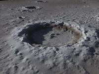
Apr 6 2010, 09:30 PM Bill Harris "Joel Raupe just identified the Ranger 9 impa... Apr 7 2010, 12:05 AM JohnVV nice shot Phil
cool find
i will be having it her... Apr 7 2010, 03:40 AM Phil Stooke I was looking for Ranger 6 when I chanced upon thi... Apr 7 2010, 11:50 AM charborob While browsing the LROC images, I found this inter... Apr 7 2010, 05:37 PM elakdawalla Oh very cool. Which of the LROC images is that fr... Apr 7 2010, 05:46 PM djellison Looks like an MI image of a concrete cast block th... Apr 7 2010, 06:20 PM Phil Stooke For both the one I posted and charborob's (not... Apr 7 2010, 08:03 PM elakdawalla Duh. Thanks. Apr 7 2010, 08:12 PM Bill Harris QUOTE (Phil)a new version of Ina in Mare Tranquill... Apr 7 2010, 09:27 PM ValterVB Here my last experiment with global map. I have us... Apr 7 2010, 11:14 PM ValterVB Sorry...
Ciao
VB Apr 8 2010, 08:23 PM Phil Stooke I said above that I had been looking for Ranger 6.... Apr 9 2010, 03:22 AM Phil Stooke ... and Ranger 8. Ejecta are not so obvious in th... Apr 9 2010, 11:44 AM Phil Stooke ... and the Apollo 17 SIVB. Here, the pixel coord... Apr 9 2010, 11:55 AM ValterVB Here you can see the video of the Moon made with L... Apr 28 2010, 09:54 AM
djellison QUOTE (Phil Stooke @ Mar 15 2010, 01:38 P... Mar 15 2010, 04:25 PM remcook Looks like flipping each 'band' will make ... Mar 15 2010, 02:13 PM Phil Stooke Until I can do a search for specific images, this ... Mar 15 2010, 02:32 PM Rick Sternbach LOLA. I want my LOLA. I've got rapid prototypi... Mar 15 2010, 06:04 PM S_Walker A bit off topic, but I was hoping someone can help... Mar 15 2010, 06:22 PM elakdawalla Just got this email:QUOTE The NASA Planetary Data ... Mar 15 2010, 07:22 PM zeBeamer The LOLA data are now also available !
In addi... Mar 16 2010, 12:19 AM volcanopele QUOTE (zeBeamer @ Mar 15 2010, 05:19 PM) ... Mar 16 2010, 05:45 AM Phil Stooke Just a taste of the bounty to come:
Tracks of L... Mar 16 2010, 01:14 AM nprev Whoa-ho-ho!!! Great eye, Phil! Mar 16 2010, 01:18 AM Phil Stooke I bet you say that to all the cartographers!
... Mar 16 2010, 01:23 AM zeBeamer Nice rendering
Yes, orbit improvement is ongoin... Mar 16 2010, 03:11 AM Rick Sternbach QUOTE (zeBeamer @ Mar 15 2010, 07:11 PM) ... Mar 16 2010, 04:15 AM Stu QUOTE (Rick Sternbach @ Mar 16 2010, 04:1... Mar 16 2010, 06:15 AM Rick Sternbach QUOTE (Stu @ Mar 15 2010, 10:15 PM) Hog a... Mar 16 2010, 05:20 PM zeBeamer QUOTE (Rick Sternbach @ Mar 16 2010, 12:2... Mar 16 2010, 07:22 PM Phil Stooke The Lunokhod 2 tracks are also clearly visible pre... Mar 16 2010, 03:59 AM nprev Emily wrote up a nice blog post with Phil's di... Mar 16 2010, 04:21 AM elakdawalla I had the most frustrating day imaginable today, s... Mar 16 2010, 04:40 AM Explorer1 Is there a thread somewhere about the new photos o... Mar 16 2010, 06:26 AM djellison You didn't look very hard. Just two threads be... Mar 16 2010, 07:24 AM S_Walker Nuts...
finally got IMG2PNG to work, and had thoug... Mar 16 2010, 06:30 PM volcanopele Most data submitted to the PDS for most missions w... Mar 16 2010, 06:35 PM S_Walker Thanks Pele! Mar 16 2010, 06:49 PM Phil Stooke PDS has now implemented the Planetary Image Atlas ... Mar 16 2010, 07:19 PM Rick Sternbach Erwan,
I haven't a clue what netcdf-binaries ... Mar 16 2010, 08:08 PM zeBeamer QUOTE (Rick Sternbach @ Mar 16 2010, 03:0... Mar 16 2010, 10:50 PM Rick Sternbach Erwan,
Okay, I get it now, as I attempted to conv... Mar 16 2010, 11:16 PM mhoward This is a great data release. The work that's ... Mar 17 2010, 12:43 AM zeBeamer QUOTE (mhoward @ Mar 16 2010, 08:43 PM) I... Mar 17 2010, 01:29 PM mhoward QUOTE (zeBeamer @ Mar 17 2010, 07:29 AM) ... Mar 17 2010, 05:26 PM Stu In the news, Phil, congratulations!
http://ww... Mar 17 2010, 06:35 AM Maquis Wow, excellent!
On which RAW was it sitting in... Mar 17 2010, 01:25 PM djellison Just playing with the 64 ppd for now - but great s... Mar 17 2010, 05:15 PM elakdawalla OK folks, I am stumped. I have downloaded a coupl... Mar 17 2010, 09:12 PM djellison Emailing someone with ISIS is probably your best b... Mar 17 2010, 10:59 PM Rick Sternbach I'm not terribly savvy about all of the data p... Mar 18 2010, 01:22 AM JohnVV IMG2PNG might not work for them
i have found tha... Mar 18 2010, 04:25 AM zeBeamer QUOTE (JohnVV @ Mar 17 2010, 11:25 PM) al... Mar 18 2010, 02:36 PM Jim Mosher Erwan,
I don't think there are any major prob... Mar 18 2010, 06:56 PM elakdawalla QUOTE (Jim Mosher @ Mar 18 2010, 10:56 AM... Mar 18 2010, 09:03 PM zeBeamer John,
Nothing is 32bit except the GRDs.
Jim,
... Mar 19 2010, 02:09 AM Jim Mosher QUOTE (zeBeamer @ Mar 19 2010, 03:09 AM) ... Mar 19 2010, 03:37 AM elakdawalla With such a short time between the spacecraft... Mar 18 2010, 05:27 AM JohnVV I'm not surprised ether for the LRO lola it is... Mar 18 2010, 05:34 AM elakdawalla (Also I feel like I should point out that there is... Mar 18 2010, 05:37 AM Ittiz I've noticed some issues at the left and right... Mar 18 2010, 12:09 PM djellison Yup - I found that as well - it's missing a fe... Mar 18 2010, 12:35 PM Ittiz QUOTE (djellison @ Mar 18 2010, 07:35 AM)... Mar 18 2010, 01:21 PM djellison FWIW - IMG2PNG does work with the IMG's for me... Mar 18 2010, 01:34 PM Ittiz I got the same problem opening it in Photoshop (it... Mar 18 2010, 02:15 PM JohnVV Did you see that, and are talking about the IMGs c... Mar 18 2010, 06:50 PM JohnVV Ittiz
on almost all ( blue marble is an exception... Mar 18 2010, 11:03 PM JohnVV hi Erwan my fault i am used to 16 bit images as -3... Mar 19 2010, 05:06 AM Phil Stooke This spot with dark rays is about where the Apollo... Mar 19 2010, 02:24 PM zeBeamer The website with the Celestia textures has been up... Mar 19 2010, 10:58 PM Phil Stooke Most people are familiar with Ina (D-Caldera). He... Mar 20 2010, 03:36 PM Ittiz This is what I do with the data: Mar 22 2010, 08:55 PM Stu Nice one, Ittiz! That's a LOT of water... Mar 22 2010, 10:41 PM Bjorn Jonsson I'm updating my IMG2PNG utility to correctly c... Mar 30 2010, 09:21 PM JohnVV QUOTE (unless I've managed to get myself total... Mar 30 2010, 09:43 PM elakdawalla I just had a long phone conversation with Mark Rob... Mar 30 2010, 10:52 PM Bjorn Jonsson Thanks, this information was very useful. I agree ... Mar 30 2010, 11:34 PM elakdawalla I asked if they couldn't just put a flag in th... Mar 31 2010, 03:08 AM kenny QUOTE (Ittiz @ Mar 22 2010, 09:55 PM) Thi... Mar 31 2010, 08:55 AM Ittiz QUOTE (kenny @ Mar 31 2010, 03:55 AM) Hey... Apr 6 2010, 07:59 PM ValterVB Comparison between Kaguya DEM 16 and LRO-LOLA DEM1... Mar 31 2010, 05:11 PM JohnVV ValterVB you might want to look at my posts on sha... Mar 31 2010, 10:23 PM ValterVB My experiments are with pure 3d not with normal ma... Apr 2 2010, 07:11 PM Zack Moratto QUOTE (ValterVB @ Apr 2 2010, 12:11 PM) I... Apr 2 2010, 11:18 PM JohnVV QUOTE Are available high resolution dataset of the... Apr 2 2010, 09:25 PM Phil Stooke Joel Raupe just identified the Ranger 9 impact cra... Apr 5 2010, 02:44 AM Phil Stooke I've been mapping the tracks of Lunokhod 2. T... Apr 5 2010, 12:17 PM S_Walker Nice job!
I think the 37km is correct- it was ... Apr 5 2010, 06:21 PM Phil Stooke "I think the 37km is correct- it was based on... Apr 5 2010, 07:04 PM ElkGroveDan Awesome work, Phil. Apr 5 2010, 07:11 PM Bernard Superb Phil,
and very appreciated,.
Thanks Apr 6 2010, 07:55 PM Phil Stooke A nice high sun view of Apollo 15.
Phil
Apr 6 2010, 09:30 PM Bill Harris "Joel Raupe just identified the Ranger 9 impa... Apr 7 2010, 12:05 AM JohnVV nice shot Phil
cool find
i will be having it her... Apr 7 2010, 03:40 AM Phil Stooke I was looking for Ranger 6 when I chanced upon thi... Apr 7 2010, 11:50 AM charborob While browsing the LROC images, I found this inter... Apr 7 2010, 05:37 PM elakdawalla Oh very cool. Which of the LROC images is that fr... Apr 7 2010, 05:46 PM djellison Looks like an MI image of a concrete cast block th... Apr 7 2010, 06:20 PM Phil Stooke For both the one I posted and charborob's (not... Apr 7 2010, 08:03 PM elakdawalla Duh. Thanks. Apr 7 2010, 08:12 PM Bill Harris QUOTE (Phil)a new version of Ina in Mare Tranquill... Apr 7 2010, 09:27 PM ValterVB Here my last experiment with global map. I have us... Apr 7 2010, 11:14 PM ValterVB Sorry...
Ciao
VB Apr 8 2010, 08:23 PM Phil Stooke I said above that I had been looking for Ranger 6.... Apr 9 2010, 03:22 AM Phil Stooke ... and Ranger 8. Ejecta are not so obvious in th... Apr 9 2010, 11:44 AM Phil Stooke ... and the Apollo 17 SIVB. Here, the pixel coord... Apr 9 2010, 11:55 AM ValterVB Here you can see the video of the Moon made with L... Apr 28 2010, 09:54 AM |

|
Lo-Fi Version | Time is now: 24th April 2024 - 12:09 PM |
|
RULES AND GUIDELINES Please read the Forum Rules and Guidelines before posting. IMAGE COPYRIGHT |
OPINIONS AND MODERATION Opinions expressed on UnmannedSpaceflight.com are those of the individual posters and do not necessarily reflect the opinions of UnmannedSpaceflight.com or The Planetary Society. The all-volunteer UnmannedSpaceflight.com moderation team is wholly independent of The Planetary Society. The Planetary Society has no influence over decisions made by the UnmannedSpaceflight.com moderators. |
SUPPORT THE FORUM Unmannedspaceflight.com is funded by the Planetary Society. Please consider supporting our work and many other projects by donating to the Society or becoming a member. |
|