March 15, 2010 PDS release |

  |
March 15, 2010 PDS release |
 Apr 7 2010, 06:20 PM Apr 7 2010, 06:20 PM
Post
#91
|
|
|
Founder  Group: Chairman Posts: 14431 Joined: 8-February 04 Member No.: 1 |
Looks like an MI image of a concrete cast block that might have been taken during an MER ORT. Very nice.
|
 |
 
|
|
Apr 7 2010, 08:03 PM
Post
#92
|
|
|
Solar System Cartographer Group: Members Posts: 10146 Joined: 5-April 05 From: Canada Member No.: 227 |
For both the one I posted and charborob's (not sure which one was cool!), the image number is in the filename if you save it.
Phil -------------------- ... because the Solar System ain't gonna map itself.
Also to be found posting similar content on https://mastodon.social/@PhilStooke NOTE: everything created by me which I post on UMSF is considered to be in the public domain (NOT CC, public domain) |
|
|
|
|
Apr 7 2010, 08:12 PM
Post
#93
|
|
 Administrator Group: Admin Posts: 5172 Joined: 4-August 05 From: Pasadena, CA, USA, Earth Member No.: 454 |
Duh. Thanks.
-------------------- My website - My Patreon - @elakdawalla on Twitter - Please support unmannedspaceflight.com by donating here.
|
|
|
|
|
Apr 7 2010, 09:27 PM
Post
#94
|
|
|
Senior Member Group: Members Posts: 2998 Joined: 30-October 04 Member No.: 105 |
QUOTE (Phil) a new version of Ina in Mare Tranquillitatis Here is an Apollo 15 orbital image of Ina and a PSRD article on lunar venting. http://www.psrd.hawaii.edu/WebImg/moon-Ina.gif http://www.psrd.hawaii.edu/Nov06/MoonGas.html Ina has been imaged in LROC image M113921307L/R and was discussed in HIGH RESOLUTION IMAGING OF INA: MORPHOLOGY, RELATIVE AGES, FORMATION. M. S. Robinson. et al, 41st Lunar and Planetary Science Conference (2010) http://www.lpi.usra.edu/meetings/lpsc2010/pdf/2592.pdf --Bill -------------------- |
|
|
|
|
Apr 7 2010, 11:14 PM
Post
#95
|
|
|
Newbie Group: Members Posts: 18 Joined: 27-February 10 From: Italy Member No.: 5235 |
Here my last experiment with global map. I have used the LDEM 64 with Blender.
http://valter31.interfree.it/LRO_LOLA_DEM_64.jpg Ciao VB ADMIN - DO NOT EMBED A 4000 x 4000 IMAGE STRAIGHT INTO A THREAD!!! Edited to change it to a link |
|
|
|
|
Apr 8 2010, 08:23 PM
Post
#96
|
|
|
Newbie Group: Members Posts: 18 Joined: 27-February 10 From: Italy Member No.: 5235 |
Sorry...
Ciao VB |
|
|
|
|
Apr 9 2010, 03:22 AM
Post
#97
|
||
|
Solar System Cartographer Group: Members Posts: 10146 Joined: 5-April 05 From: Canada Member No.: 227 |
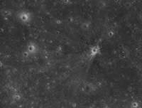
I said above that I had been looking for Ranger 6. Here it is:
The LROC team just put out a list of sites they have found so far. Turns out Ranger 6 was in the same image I was looking at earlier, I just didn't see it. Phil -------------------- ... because the Solar System ain't gonna map itself.
Also to be found posting similar content on https://mastodon.social/@PhilStooke NOTE: everything created by me which I post on UMSF is considered to be in the public domain (NOT CC, public domain) |
|
|
|
|
|
|
Apr 9 2010, 11:44 AM
Post
#98
|
||
|
Solar System Cartographer Group: Members Posts: 10146 Joined: 5-April 05 From: Canada Member No.: 227 |
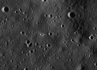
... and Ranger 8. Ejecta are not so obvious in this low sun view. The crater is right at the middle of this cropped image, with a bright 'arrow' of ejecta appearing to point at it. The 'arrow' is really a bit of bright ejecta fringed by two dark rays. This image was subsampled 2x for downlink so it has only 1 m/pixel resolution.
Phil
-------------------- ... because the Solar System ain't gonna map itself.
Also to be found posting similar content on https://mastodon.social/@PhilStooke NOTE: everything created by me which I post on UMSF is considered to be in the public domain (NOT CC, public domain) |
|
|
|
|
|
|
Apr 9 2010, 11:55 AM
Post
#99
|
||
|
Solar System Cartographer Group: Members Posts: 10146 Joined: 5-April 05 From: Canada Member No.: 227 |
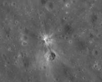
... and the Apollo 17 SIVB. Here, the pixel coordinates given in their table only work after the raw image is flipped.
EDIT: This does get confusing. Their pixel coordinates have to be flipped to get the right spot. But the image as presented is in the correct orientation. I had flipped the image to match their coordinates, but now I see they had already taken care of the image (but NOT the coordinates!). So my image shown here was originally reversed. I have now corrected it. (PS - how do I know it's the right way round? - comparison with a Lunar Orbiter 4 image of the area) Phil
-------------------- ... because the Solar System ain't gonna map itself.
Also to be found posting similar content on https://mastodon.social/@PhilStooke NOTE: everything created by me which I post on UMSF is considered to be in the public domain (NOT CC, public domain) |
|
|
|
|
|
|
Apr 28 2010, 09:54 AM
Post
#100
|
|
|
Newbie Group: Members Posts: 18 Joined: 27-February 10 From: Italy Member No.: 5235 |
Here you can see the video of the Moon made with LDEM 64.
I have used all the point from 71 to -71 of latitude. Ciao VB |
|
|
|
|

|
Lo-Fi Version | Time is now: 19th April 2024 - 07:53 PM |
|
RULES AND GUIDELINES Please read the Forum Rules and Guidelines before posting. IMAGE COPYRIGHT |
OPINIONS AND MODERATION Opinions expressed on UnmannedSpaceflight.com are those of the individual posters and do not necessarily reflect the opinions of UnmannedSpaceflight.com or The Planetary Society. The all-volunteer UnmannedSpaceflight.com moderation team is wholly independent of The Planetary Society. The Planetary Society has no influence over decisions made by the UnmannedSpaceflight.com moderators. |
SUPPORT THE FORUM Unmannedspaceflight.com is funded by the Planetary Society. Please consider supporting our work and many other projects by donating to the Society or becoming a member. |
|