Processed images from Earth orbiting spacecraft |

  |
Processed images from Earth orbiting spacecraft |
 Nov 15 2012, 12:37 AM Nov 15 2012, 12:37 AM
Post
#1
|
||
 IMG to PNG GOD  Group: Moderator Posts: 2254 Joined: 19-February 04 From: Near fire and ice Member No.: 38 |
For some reason it didn't come to my attention until recently (less than a year ago) that the entire Landsat imagery plus a lot of data from other Earth orbiting spacecraft is freely available for download at http://earthexplorer.usgs.gov/ . Maybe this is because for a long time it was more difficult to find good and freely available global maps (or get data to make maps) of the Earth than it was for other planets/satellites - I somehow was under the impression that the vast majority of Earth imagery was commercial.
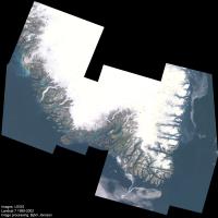
The Earth is visually a really spectacular planet (in my opinion possibly even the most photogenic body in the entire solar system) so it's possible to get spectacular results by downloading some of this data. The data can be selected by spacecraft, instrument, location, months/years, cloud cover percentage etc. Data is available from several Landsat satellites but the best data is from Landsat 7; Landsat 5 is also good. This is multispectral data with a resolution of 30 meters/pixel. Here is an experimental and spectacular 12 frame mosaic showing southern Greenland (10% the original size):
The full size version (19000 pixels square) plus additional information can be seen in this blog entry at the Planetary Society website. This image shows a spectacular and complex 'maze' of long and narrow fjords and islands, narrow valleys flanked by steep mountains, glaciers and glacial rivers, countless lakes and ponds and in general a landscape that has been shaped by advancing and retreating glaciers, depending on climate. One important thing to note is that overall this data turned out to be easier to process than is typical for data from other planets. |
|
 |
 
|
|
|
Jun 8 2013, 06:15 PM
Post
#2
|
||
|
IMG to PNG GOD Group: Moderator Posts: 2254 Joined: 19-February 04 From: Near fire and ice Member No.: 38 |
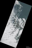
Landsat 8 was launched in February. Following a period of checkouts and calibrations it started regular operations in late May. Below is a mosaic of three Landsat 8 images showing a part of northern Iceland. The full size version (12020x18130 pixels) can be downloaded here, the version below is 30% of the original size:
The images were obtained on June 4, 2013 near local noon. The resolution of the full size version is 30 m/pixel. At this time the weather was characterized by strong southerly winds and mountain waves are prominent, especially left of center. The Landsat 8 image data is of significantly higher quality than earlier Landsat data. In particular, the images are 16 bits which is significant when dealing with high dynamic range scenes where glaciers, snow and clouds are visible together with relatively dark terrain. In this case, the clouds were typically brighter than the dark terrain by a factor of ~5 in the original images . Some areas have relatively fresh snow that is even brighter. The version above has been processed to brighten the dark terrain without losing too much of the detailed structure visible in the clouds. These images are made available shortly after acquisition, for example I downloaded some images only several hours after they were taken. |
|
|
|
|
|
|
Feb 13 2015, 09:49 PM
Post
#3
|
|
 Senior Member Group: Members Posts: 1669 Joined: 5-March 05 From: Boulder, CO Member No.: 184 |
There are some other satellites where color processing can be considered of the land surface and clouds. This includes quite a few spectral bands in DISCOVR - EPIC instrument (near future - as discussed in another thread), VIIRS, and GOES-R ABI (future).
So for the present, we can consider VIIRS polar orbiter also having quite a few spectral bands. GOES-R ABI will have good rapid update frequency (just minutes) in geosynchronous orbit, though it only has two bands in the visible region with others in the near-IR. Some other geosynchronous weather satellites (apart from GOES) have or will have multiple visible bands. Steve -------------------- Steve [ my home page and planetary maps page ]
|
|
|
|
|
Oct 28 2017, 12:01 AM
Post
#4
|
|
|
Member Group: Members Posts: 923 Joined: 10-November 15 Member No.: 7837 |
Here are some processed, retimed sequences from ISS courtesy of NASA & Earth Science and Remote Sensing Unit...
   -------------------- |
|
|
|
|
Oct 28 2017, 06:01 AM
Post
#5
|
|
|
Member Group: Members Posts: 184 Joined: 2-March 06 Member No.: 692 |
THANK YOU! Works of art.
|
|
|
|
|
Oct 29 2017, 12:20 PM
Post
#6
|
|
 Senior Member Group: Members Posts: 3648 Joined: 1-October 05 From: Croatia Member No.: 523 |
QUOTE (Sean @ Oct 28 2017, 01:01 AM)  Here are some processed, retimed sequences from ISS courtesy of NASA & Earth Science and Remote Sensing Unit... Beautiful videos, but the "Nadir" one has me scratching my head. Based on the inclination of the ISS orbit and the ground track motion over Italy, it makes me think the sequence is actually running backwards in time? Also, in the aurora video, it's almost just as fascinating to look for satellites moving in the background as dim dots as well as a sunglint off of one at 11 seconds into the video. -------------------- |
|
|
|
|
Oct 29 2017, 12:28 PM
Post
#7
|
|
|
Member Group: Members Posts: 923 Joined: 10-November 15 Member No.: 7837 |
It is indeed running backwards. I should have specified this, sorry. It took an age to get this rendered and it slipped my mind. Purely an aesthetic choice.
-------------------- |
|
|
|
|
Nov 1 2017, 11:47 PM
Post
#8
|
|
|
Merciless Robot Group: Admin Posts: 8785 Joined: 8-December 05 From: Los Angeles Member No.: 602 |
Spellbinding, Sean.

-------------------- A few will take this knowledge and use this power of a dream realized as a force for change, an impetus for further discovery to make less ancient dreams real.
|
|
|
|
|
Dec 31 2017, 04:45 PM
Post
#9
|
|
|
Member Group: Members Posts: 923 Joined: 10-November 15 Member No.: 7837 |
Moonlight Flight
 4k 60fps over on YouTube Expedition 53 November 5, 2017 from 22:29:56 to 23:03:24 GMT From the South Atlantic Ocean to Kazakhstan Original timelapse extended x3, many repairs & processed. Kangaru by Jóhann Jóhannsson -------------------- |
|
|
|
|
Jan 1 2018, 08:30 AM
Post
#10
|
|
|
Member Group: Members Posts: 184 Joined: 2-March 06 Member No.: 692 |
Very nice. Thank You!
|
|
|
|
|
Jan 2 2018, 01:28 AM
Post
#11
|
|
|
Member Group: Members Posts: 923 Joined: 10-November 15 Member No.: 7837 |
Here is the same source material re-tweened in 60fps to approximate real time based on 1,998 source frame count & 22:29:56 to 23:03:24 time stamps
3 minute sequence on Flickr...  10 minute sequence on Youtube I took care to choose footage that contained no lightning as that would spoil the intent, though it is possible to repair those flashes before tweening and re-insert them during real time pass. -------------------- |
|
|
|
|
Jan 3 2018, 04:27 AM
Post
#12
|
|
|
Member Group: Members Posts: 923 Joined: 10-November 15 Member No.: 7837 |
Africa to Japan
 Expedition 34 January 4, 2013 from 05:23:00 to 05:56:16 GMT From the border of Congo and the Democratic Republic of Congo to just east of Japan. Original timelapse extended x5 & processed. 'Odi et Amo' by Jóhann Jóhannsson 4k60 version over on Youtube Source extended x60 to approximate real time ( 3 minute excerpt )  4k60 version over on Youtube Finally after a 22 hour process & 3 hour upload Full 33m16s 4k60 version over on Youtube 'Somnus' by Phaeleh -------------------- |
|
|
|
|
Feb 5 2018, 07:03 PM
Post
#13
|
|
|
Member Group: Members Posts: 923 Joined: 10-November 15 Member No.: 7837 |
I made a movie.
 ORBIT - A Journey Around Earth in Real Time Music by Phaeleh Orbit is a real time reconstruction of time lapse photography taken on board the International Space Station by NASA's Earth Science & Remote Sensing Unit. The structure of the film is built around a nested selection of Phaeleh's last three albums; Lost Time, Illusion of the Tale & Somnus. The tone & pacing of each track influenced the choice of material used. Typically each time lapse sequence was photographed at 1 frame per second. Each sequence was processed in Photoshop. A dirtmap was made in order to repair dust, blemishes and hot pixel artifacts that would otherwise confuse the re-timing phase of the workflow resulting in strobes and distracting blurs. Image processing techniques were used to emphasize features on the Earth's surface. Every sequence consists of a number of layers that when masked, processed & blended correctly produce the final look of each shot. To make sure each sequence was recreated faithfully to the actual rate of speed observed I referenced time-stamps on the first and last frame in the sequence and used frame interpolation software to produce the other 59 frames. The length of the film is exactly the length of time it takes ISS to orbit the Earth once, 92 minutes & 39 seconds. -------------------- |
|
|
|
|
Feb 8 2018, 08:36 PM
Post
#14
|
|
|
Member Group: Members Posts: 923 Joined: 10-November 15 Member No.: 7837 |
'Cebile'
Tropical Cyclone Cebile from January 30th as photographed by Himawari8 [time-lapse] & ISS ESRSU [ real time time-lapse reconstruct ]  Full 4k60 version on Youtube -------------------- |
|
|
|
|
Feb 20 2018, 06:44 PM
Post
#15
|
|
|
Member Group: Members Posts: 923 Joined: 10-November 15 Member No.: 7837 |
Volcano Sinabung time-lapse interpolation from Himawari8
 -------------------- |
|
|
|
|

|
Lo-Fi Version | Time is now: 27th September 2024 - 07:19 AM |
|
RULES AND GUIDELINES Please read the Forum Rules and Guidelines before posting. IMAGE COPYRIGHT |
OPINIONS AND MODERATION Opinions expressed on UnmannedSpaceflight.com are those of the individual posters and do not necessarily reflect the opinions of UnmannedSpaceflight.com or The Planetary Society. The all-volunteer UnmannedSpaceflight.com moderation team is wholly independent of The Planetary Society. The Planetary Society has no influence over decisions made by the UnmannedSpaceflight.com moderators. |
SUPPORT THE FORUM Unmannedspaceflight.com is funded by the Planetary Society. Please consider supporting our work and many other projects by donating to the Society or becoming a member. |
|