Journey to Mt Sharp - Part 1A: Darwin, Sol392 [Sep13,'13] to Sol401 [Sep22,'13] (Waypoint 1) |

  |
Journey to Mt Sharp - Part 1A: Darwin, Sol392 [Sep13,'13] to Sol401 [Sep22,'13] (Waypoint 1) |
 Sep 17 2013, 02:42 PM Sep 17 2013, 02:42 PM
Post
#16
|
||
 Member  Group: Members Posts: 219 Joined: 14-November 11 From: Washington, DC Member No.: 6237 |
For those like me who need as much context as possible, here's a full scale (.25 m/px) crop of the only HiRise image I could find that covered the region of Darwin in color (http://www.uahirise.org/ESP_029957_1755). The colors are IRB and stretched, north up. Sun angle is actually pretty low, 37 deg above the horizon from the SW (local time 15:27).
Darwin is bright area just left of center.
(mods, please move to map thread if more appropriate, thanks.) |
|
 |
 
|
|
|
Sep 17 2013, 06:47 PM
Post
#17
|
||
 Member Group: Members Posts: 334 Joined: 11-December 12 From: The home of Corby Crater (Corby-England) Member No.: 6783 |
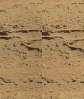
Sol 395 MC Pano from the six full frames received so far (18:00 UTC), auto stitched in Photoshop, no adjustments to colour, saturation, levels etc. Reduced in size to fit upload limits.
Stunning detail; all that 'rubble' reminds me of a film scene after an explosion of some kind. Those hills/dunes still look a long way of though ....sigh.
Attached thumbnail(s)
|
|
|
|
|
|
|
Sep 17 2013, 08:47 PM
Post
#18
|
||||
|
Member Group: Members Posts: 219 Joined: 14-November 11 From: Washington, DC Member No.: 6237 |
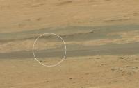
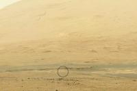
Here's another long-range RMI image, from Sol 396 looking to the ESE. This is a focus merge of 6 images, flatfielded and contrast enhanced. I am pretty sure it's it's aimed at the location circled in the NAVCAM image below, so the upper half of the image may show the flank of a "mesa" near the dunes (edit: seen also from a slightly different angle in the Sol 389 mastcam image also attached)
|
|||
|
|
|
|||
|
Sep 17 2013, 09:07 PM
Post
#19
|
|
|
Member Group: Members Posts: 219 Joined: 14-November 11 From: Washington, DC Member No.: 6237 |
Looks like they also did multispectral MR100 imaging of the same spot on sol 387 (far right side of this image and subsequent 4 IR images). Wonder if they are using the passive spectroscopy capabilities of ChemCam and taking the above images to document it.
|
|
|
|
|
Sep 17 2013, 09:08 PM
Post
#20
|
||
|
Solar System Cartographer Group: Members Posts: 10151 Joined: 5-April 05 From: Canada Member No.: 227 |
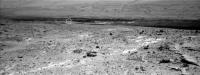
Amazing picture! I think it's here, marked on a pan from sol 364 so not seeing the same foreground features. (so this is the left side, not the far right side, of the pic Greenish just linked to)
Phil
-------------------- ... because the Solar System ain't gonna map itself.
Also to be found posting similar content on https://mastodon.social/@PhilStooke Maps for download (free PD: https://upload.wikimedia.org/wikipedia/comm...Cartography.pdf NOTE: everything created by me which I post on UMSF is considered to be in the public domain (NOT CC, public domain) |
|
|
|
|
|
|
Sep 17 2013, 10:46 PM
Post
#21
|
||
|
Founder Group: Chairman Posts: 14432 Joined: 8-February 04 Member No.: 1 |
QUOTE (blake @ Sep 16 2013, 04:18 PM)  Sol 394 MAHLI blink image. Photoshop adjusted, cropped, and downsized to fit upload limits. The very same, as an anaglyph
Attached thumbnail(s)
|
|
|
|
|
|
|
Sep 18 2013, 12:15 AM
Post
#22
|
|
|
Solar System Cartographer Group: Members Posts: 10151 Joined: 5-April 05 From: Canada Member No.: 227 |
I have a bit of a placename fetish, so I'm always on the lookout for new names at the Curiosity site. The most inefficient way possible to distribute such information has got to be:
http://mars.jpl.nasa.gov/explore/curiosity/ ... but when you get the hang of it you can get to the most recent 'stories' (they really should default to the most recent, not the first) and sometimes they contain names. Today it's Bardin Bluffs, the little rock ledge forming the north edge of Darwin. Phil -------------------- ... because the Solar System ain't gonna map itself.
Also to be found posting similar content on https://mastodon.social/@PhilStooke Maps for download (free PD: https://upload.wikimedia.org/wikipedia/comm...Cartography.pdf NOTE: everything created by me which I post on UMSF is considered to be in the public domain (NOT CC, public domain) |
|
|
|
|
Sep 18 2013, 08:13 AM
Post
#23
|
|
 Senior Member Group: Members Posts: 1084 Joined: 19-February 05 From: Close to Meudon Observatory in France Member No.: 172 |
QUOTE (Greenish @ Sep 17 2013, 10:47 PM) Here's another long-range RMI image, from Sol 396 Thanks a lot for your incredible and so "sharp" picture ! When you look closely to its upper portion, you see like "veined" rocks ! 
|
|
|
|
|
Sep 18 2013, 07:16 PM
Post
#24
|
||
|
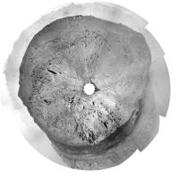
Solar System Cartographer Group: Members Posts: 10151 Joined: 5-April 05 From: Canada Member No.: 227 |
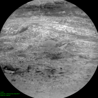
Quick and dirty pan in circular form showing our current location.
Phil
-------------------- ... because the Solar System ain't gonna map itself.
Also to be found posting similar content on https://mastodon.social/@PhilStooke Maps for download (free PD: https://upload.wikimedia.org/wikipedia/comm...Cartography.pdf NOTE: everything created by me which I post on UMSF is considered to be in the public domain (NOT CC, public domain) |
|
|
|
|
|
|
Sep 18 2013, 09:31 PM
Post
#25
|
|
|
Member Group: Members Posts: 866 Joined: 15-March 05 From: Santa Cruz, CA Member No.: 196 |
expectedly fragile plate in center of upper right quadrant sol 395 Rm100 appears to be supporting an inordinately large rock, need a stereo view to be sure.
|
|
|
|
|
Sep 18 2013, 09:48 PM
Post
#26
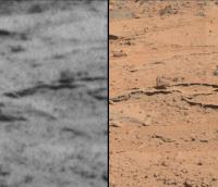
|
||
 Senior Member Group: Moderator Posts: 3431 Joined: 11-August 04 From: USA Member No.: 98 |
QUOTE (atomoid @ Sep 18 2013, 02:31 PM) expectedly fragile plate in center of upper right quadrant sol 395 Rm100 appears to be supporting an inordinately large rock, need a stereo view to be sure. Navcam-Mastcam stereo (freeviewing) doesn't help much in this case, but it sure looks like that, doesn't it.
Attached thumbnail(s)
|
|
|
|
|
|
|
Sep 18 2013, 10:02 PM
Post
#27
|
|
 Member Group: Members Posts: 222 Joined: 7-August 12 From: Garberville, CA Member No.: 6500 |
Sol 396 - Navcam 360's...
2-D (full frame - NRB): .jpg) Anaglyph: (bottom cropped):  Really loving the nice clear skies of late. -------------------- "We shall not cease from exploration, and the end of all our exploring will be to arrive where we started and know the place for the first time." -T.S. Eliot
|
|
|
|
|
Sep 19 2013, 11:29 PM
Post
#28
|
||
|
Member Group: Members Posts: 866 Joined: 15-March 05 From: Santa Cruz, CA Member No.: 196 |
QUOTE (mhoward @ Sep 18 2013, 01:48 PM) Navcam-Mastcam stereo (freeviewing) doesn't help much in this case, but it sure looks like that, doesn't it. was able to grab a bit of parallax from the adjoining mastcam segment though with the overlap so tiny the interpretation is up for grabs. just as interesting is the diamondesque shadow in the spheroid rock at right, which appears darker than any other shadows in the scene.. compression artifact? theres more dark shadows including in another sphericalish rock near far left under the amazing 'coral shelf' complexin the original image
|
|
|
|
|
|
|
Sep 20 2013, 03:23 AM
Post
#29
|
||
|
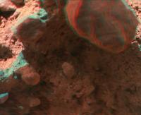
Junior Member Group: Members Posts: 31 Joined: 1-July 13 From: Ithaca, NY Member No.: 6966 |
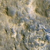
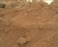
Sol 398 MAHLI blink image. Cropped/downsized to the upload limit and adjusted brightness so the two images would match. Interesting "mushroom cap" shape in the foreground.
|
|
|
|
|
|
|
Sep 20 2013, 03:44 AM
Post
#30
|
||
|
Junior Member Group: Members Posts: 31 Joined: 1-July 13 From: Ithaca, NY Member No.: 6966 |
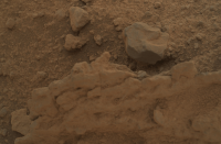
One more Sol 398 blink. Cropped and adjusted brightness to match images.
|
|
|
|
|
|
|

|
Lo-Fi Version | Time is now: 26th April 2024 - 09:32 AM |
|
RULES AND GUIDELINES Please read the Forum Rules and Guidelines before posting. IMAGE COPYRIGHT |
OPINIONS AND MODERATION Opinions expressed on UnmannedSpaceflight.com are those of the individual posters and do not necessarily reflect the opinions of UnmannedSpaceflight.com or The Planetary Society. The all-volunteer UnmannedSpaceflight.com moderation team is wholly independent of The Planetary Society. The Planetary Society has no influence over decisions made by the UnmannedSpaceflight.com moderators. |
SUPPORT THE FORUM Unmannedspaceflight.com is funded by the Planetary Society. Please consider supporting our work and many other projects by donating to the Society or becoming a member. |
|