MSL landing site: Gale Crater |

  |
MSL landing site: Gale Crater |
 Aug 6 2012, 03:38 AM Aug 6 2012, 03:38 AM
Post
#346
|
|||
 Senior Member  Group: Members Posts: 1465 Joined: 9-February 04 From: Columbus OH USA Member No.: 13 |
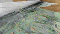
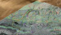
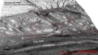
Another possible traverse is shown in Geologic mapping and characterization of Gale Crater and implications for its potential as a Mars Science Laboratory landing site by Anderson and Bell. Traced out in Google Earth it looks like the white line below:
The yellow line is the traverse from MSL Landing Sites: Gale, Reconsidered (PDF) -- Edgett, Milliken, Grotzinger, Malin They end up at the same area, the "erosional unconformity." Total length is 22 km. Another view:
-------------------- |
||
 |
 
|
||
|
Aug 28 2012, 03:17 PM
Post
#347
|
||
 Junior Member Group: Members Posts: 66 Joined: 3-August 12 Member No.: 6454 |
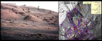
Still trying to get a better handle on where MSL is likely to be driving, in a year or two.
While the traverse from Glenelg to the base of Mount Sharp seems totally shrouded in mystery for now, in the mean time Id like to get a better idea of where the proposed routes at Mount Sharp show up on the fabulous view from ground, that JPL released yesterday. Ive tried to ID the corresponding features with letters black in the ground view, orange in the satellite photo with traverse routes. Not too sure about some of them, so some helpful tips would be appreciated. Has anyone tried to map the traverse routes on the ground view yet ? (Thnx)
|
|
|
|
|
|
|
Aug 28 2012, 03:36 PM
Post
#348
|
|
 Member Group: Members Posts: 697 Joined: 3-December 04 From: Boulder, Colorado, USA Member No.: 117 |
Walfy did a similar feature correlation a couple of days ago which I think was more accurate- using the stereo orbital view, as he did, really helps make things clear. I'd love to see someone take the next step and add the traverse routes, though...
John |
|
|
|
|
Aug 28 2012, 03:53 PM
Post
#349
|
|
 Administrator Group: Admin Posts: 5172 Joined: 4-August 05 From: Pasadena, CA, USA, Earth Member No.: 454 |
They mentioned in the briefing yesterday a plan to do long-baseline stereo with Mastcam of that spot from their new position. That'll really help line things up.
-------------------- My website - My Patreon - @elakdawalla on Twitter - Please support unmannedspaceflight.com by donating here.
|
|
|
|
|
Aug 28 2012, 07:02 PM
Post
#350
|
|||||
 The Poet Dude Group: Moderator Posts: 5551 Joined: 15-March 04 From: Kendal, Cumbria, UK Member No.: 60 |
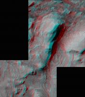
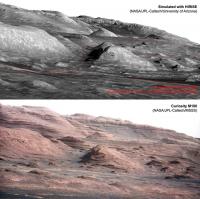
There was a great picture released yesterday during the press conference, on which the MSL team had spotted, and highlighted, a Curiosity-sized rock off in the distance. I thought this might be useful in giving a sense of scale to some of the features over there in The Promised Land, so I hit Photoshop, and put that rock in the landscape at various points, to give - I hope - a pretty good sense of scale of the terrain Curiosity will eventually drive through. Not claiming this is 100% accurate, but it does bring it home to you what an incredible place is ahead of us.
So, in the following black and white images, look for a dark line running top-bottom, with some dark dots at various points along it. These dots are clones of the aforementioned rock, to show the (approximate) size of the rover. (Note: the line is just an imaginary 'trail' through the landscape to make spotting the 'rover' easier. Not suggesting it's a possible traverse!)
The scale really hits you in the face when you look at it in 3D. I've circled rocks the same size as the rover in the following images...
On that second 3D image the feature circled is actually slightly smaller than Curiosity, but there was nothing larger in the area to use. -------------------- |
||||
|
|
|
||||
|
Aug 28 2012, 09:28 PM
Post
#351
|
||
 Member Group: Members Posts: 404 Joined: 5-January 10 Member No.: 5161 |
Very cool, Stu! I love those types of hypothetical path outlines. It inspired me to make this quick one from landing site to Glenelg:
|
|
|
|
|
|
|
Aug 28 2012, 11:22 PM
Post
#352
|
|
|
The Poet Dude Group: Moderator Posts: 5551 Joined: 15-March 04 From: Kendal, Cumbria, UK Member No.: 60 |
Full size version - with virtual Curiosities show - of a purely imaginary traverse through "The Promised Land", including the "Martian Monument Valley"...
http://galegazette.files.wordpress.com/201...plus-c-full.jpg (Follow Curiosity on her trek by looking for and then following the dark line which begins upper right. Dotted along the line are virtual rovers, shown to approx scale with the landscape. ) -------------------- |
|
|
|
|
Aug 29 2012, 02:39 PM
Post
#353
|
|||
|
Junior Member Group: Members Posts: 59 Joined: 18-July 07 From: London, UK Member No.: 2873 |
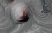
QUOTE (john_s @ Aug 28 2012, 04:36 PM)  Walfy did a similar feature correlation a couple of days ago which I think was more accurate- using the stereo orbital view, as he did, really helps make things clear. I'd love to see someone take the next step and add the traverse routes, though... John Bait taken  I haven't quite got the field of view exactly the same (mainly due to my computer throwing a wobbler with all the HiRISE DEMs I keep pushing at it), but it's not a bad match. It's views like these that remind just what amazing datasets these HiRISE DEMs really are. And of course, the real view from the surface is pretty sweet too 
But it's a bit difficult to make out the exact routes from that angle so I thought I'd take a step back at the larger picture. Once you get your eye in (follow the arrow) it's fairly easy to see where Curiosity is looking.
All in all it's a pretty good view round here isn't it? Pete |
||
|
|
|
||
|
Aug 29 2012, 06:24 PM
Post
#354
|
|
|
Junior Member Group: Members Posts: 59 Joined: 12-March 10 From: Austin, TX Member No.: 5262 |
Any chance of giving the mound with the Curiosity rock on it a name? It shows up a lot and it would be useful to label it in various views as a central landmark, thereby enabling viewers to get oriented. I think it's "F" in Jaro's pic. I know JPL will give it a name later, but couldn't we use a temporary name?
|
|
|
|
|
Aug 29 2012, 10:10 PM
Post
#355
|
||
|
Junior Member Group: Members Posts: 66 Joined: 3-August 12 Member No.: 6454 |
QUOTE (pgrindrod @ Aug 29 2012, 03:39 PM) Bait taken I haven't quite got the field of view exactly the same (mainly due to my computer throwing a wobbler with all the HiRISE DEMs I keep pushing at it), but it's not a bad match. It's views like these that remind just what amazing datasets these HiRISE DEMs really are. And of course, the real view from the surface is pretty sweet too But it's a bit difficult to make out the exact routes from that angle so I thought I'd take a step back at the larger picture. Once you get your eye in (follow the arrow) it's fairly easy to see where Curiosity is looking. That's wonderful Pete! ...thanks! Now I can see where my errors were.... especially hill "F" was way off. Hopefully this one is much better...
|
|
|
|
|
|
|
Aug 30 2012, 01:56 AM
Post
#356
|
|
|
Senior Member Group: Members Posts: 2075 Joined: 13-February 10 From: Ontario Member No.: 5221 |
Right side is upside down, Jaro.
|
|
|
|
|
Aug 30 2012, 03:14 AM
Post
#357
|
|
 The Insider Group: Members Posts: 669 Joined: 3-May 04 Member No.: 73 |
I think this was intended - it was rotated to match the orientation of the features in the MSL image.
|
|
|
|
|
Sep 7 2012, 10:30 AM
Post
#358
|
||
|
Member Group: Members Posts: 102 Joined: 29-January 10 From: Poland Member No.: 5205 |
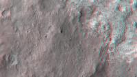
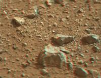
I make 3D animation from this one image:
http://mars.jpl.nasa.gov/msl/multimedia/ra...1_DXXX&s=24 My workspace: 1) add layer with gradient 2) with lasso I select some rocks and simply little brightnes this area 3) save depth map 4) add color image and depth map to stereo tracer and generate animation AVI Here this animation (1.7 MB) http://ge.tt/50xaTJN/v/0?c and anaglyph version
-------------------- Adam Hurcewicz from Poland
|
|
|
|
|
|
|
Sep 7 2012, 11:37 AM
Post
#359
|
|
 Member Group: Members Posts: 809 Joined: 3-June 04 From: Brittany, France Member No.: 79 |
QUOTE (Adam Hurcewicz @ Sep 7 2012, 10:30 AM) Here this animation (1.7 MB) http://ge.tt/50xaTJN/v/0?c Great job ! Really impressive ! Do you plan to do the same kind of animation for other pairs of Mastcam pics ? -------------------- |
|
|
|
|
Sep 7 2012, 03:32 PM
Post
#360
|
|
|
Junior Member Group: Members Posts: 31 Joined: 10-August 12 Member No.: 6526 |
QUOTE (neo56 @ Sep 7 2012, 04:37 AM) Great job ! Really impressive ! Do you plan to do the same kind of animation for other pairs of Mastcam pics ? Yes, very nice! But, unless I misunderstood, I think he synthesized this from a single image, not a pair. Mark |
|
|
|
|

|
Lo-Fi Version | Time is now: 16th April 2024 - 07:17 PM |
|
RULES AND GUIDELINES Please read the Forum Rules and Guidelines before posting. IMAGE COPYRIGHT |
OPINIONS AND MODERATION Opinions expressed on UnmannedSpaceflight.com are those of the individual posters and do not necessarily reflect the opinions of UnmannedSpaceflight.com or The Planetary Society. The all-volunteer UnmannedSpaceflight.com moderation team is wholly independent of The Planetary Society. The Planetary Society has no influence over decisions made by the UnmannedSpaceflight.com moderators. |
SUPPORT THE FORUM Unmannedspaceflight.com is funded by the Planetary Society. Please consider supporting our work and many other projects by donating to the Society or becoming a member. |
|