MSL at Rocknest, First scoop samples - sols 57-101 |

  |
MSL at Rocknest, First scoop samples - sols 57-101 |
 Nov 16 2012, 11:20 AM Nov 16 2012, 11:20 AM
Post
#466
|
|
 Senior Member  Group: Members Posts: 1619 Joined: 12-February 06 From: Bergerac - FR Member No.: 678 |
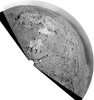
And my take also on this pan
 Enhanced levels in order to pop-out some details on the rim's mountains. Enhanced levels in order to pop-out some details on the rim's mountains.
-------------------- |
 |
 
|
|
Nov 16 2012, 08:14 PM
Post
#467
|
|
|
Member Group: Members Posts: 866 Joined: 15-March 05 From: Santa Cruz, CA Member No.: 196 |
QUOTE (ronald @ Nov 15 2012, 10:49 AM)  ...The Sol 78 pan is also pretty nice - especially the crazy stone on the left side ... seems almost as if that crazy stone got flipped upside down (reminds me of Natural Bridges beach formation in my hometown before it collapsed), and there do seem to be a lot of rocks where the part in contact with the sand seems to have eroded much more (and recently exposed) than the more perennially exposed part, seems there could be multiple things going on geologically speaking (and of course admittedly including some observation bias). heres another interesting protrusion (stovepipe with 'mouth' agape to right). |
|
|
|
|
Nov 17 2012, 02:39 PM
Post
#468
|
|
|
Solar System Cartographer Group: Members Posts: 10150 Joined: 5-April 05 From: Canada Member No.: 227 |
At last - a small movement. I'm still trying to characterize it, may be mostly a turn in place. EDIT - no, they have moved so the rover is sitting right on top of the little drift from which samples were scooped. Compare front hazcams with sol 56. Route map update on Monday.
Phil -------------------- ... because the Solar System ain't gonna map itself.
Also to be found posting similar content on https://mastodon.social/@PhilStooke NOTE: everything created by me which I post on UMSF is considered to be in the public domain (NOT CC, public domain) |
|
|
|
|
Nov 17 2012, 03:37 PM
Post
#469
|
|
|
Senior Member Group: Members Posts: 1619 Joined: 12-February 06 From: Bergerac - FR Member No.: 678 |
On the move again ! Yay~
Two navcam pan, between two small bump I think. 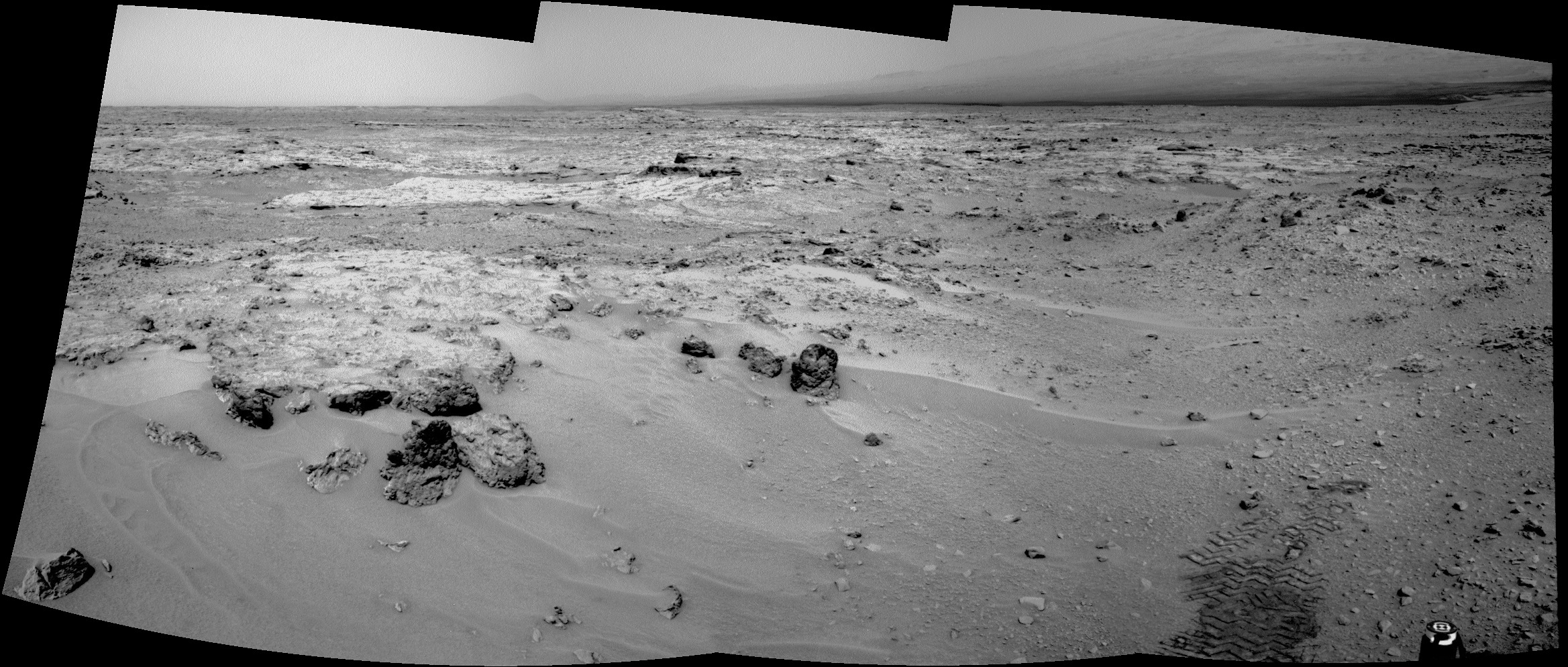 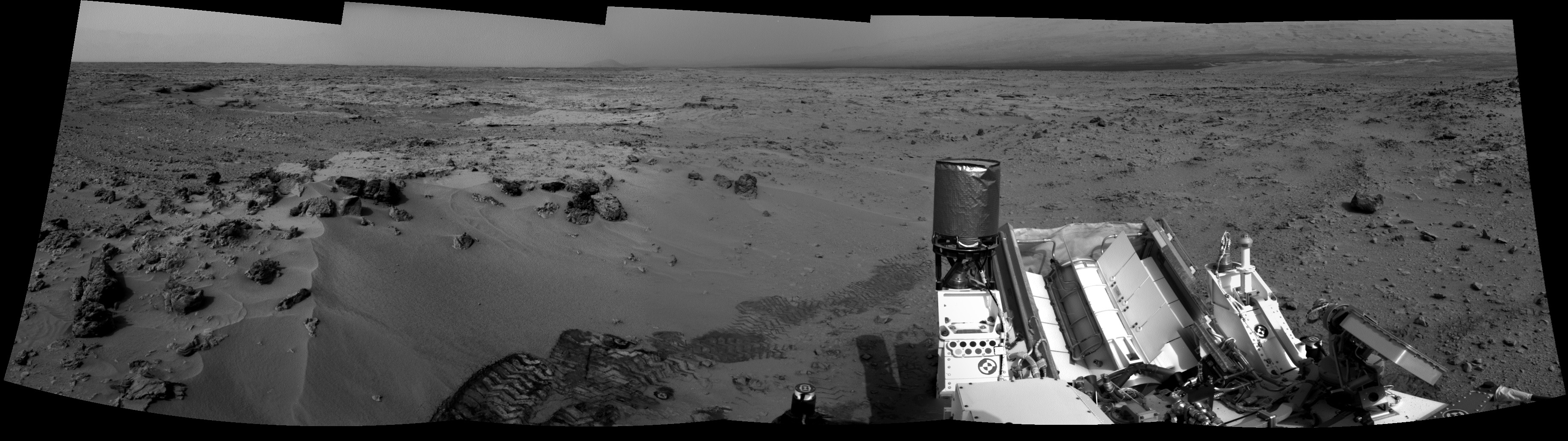
-------------------- |
|
|
|
|
Nov 17 2012, 04:45 PM
Post
#470
|
||
|
Solar System Cartographer Group: Members Posts: 10150 Joined: 5-April 05 From: Canada Member No.: 227 |
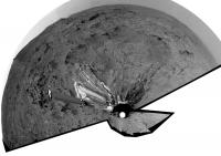
Ant's second half-pan in circular format. Looks like Curiosity backed up to the north slightly, then drove south just a couple of meters and turned clockwise a bit.
Phil
PS It will be interesting to see how the 'triple junction' at Glenelg is examined. Three units - the fractured and layered rock of the high thermal inertia unit, a cratered plains unit and a hummocky unit where Curiosity landed. Ideally all three should be analyzed and their contacts examined. We've been on the hummocky unit but it has not really been analyzed thoroughly (the scoops were all in wind-blown dust on top of the hummocky unit) - so we presumably have ChemCam data on parts of it, but reallly nothing else. So will we see stops on all three units, or will attention focus on the fracture hi-TI unit with the rest left to photo-geology? -------------------- ... because the Solar System ain't gonna map itself.
Also to be found posting similar content on https://mastodon.social/@PhilStooke NOTE: everything created by me which I post on UMSF is considered to be in the public domain (NOT CC, public domain) |
|
|
|
|
|
|
Nov 17 2012, 08:19 PM
Post
#471
|
|
 Member Group: Members Posts: 219 Joined: 14-November 11 From: Washington, DC Member No.: 6237 |
QUOTE (Phil Stooke @ Nov 17 2012, 10:39 AM) ... rover is sitting right on top of the little drift from which samples were scooped. ... Perhaps aiming for co-located DAN measurement? |
|
|
|
|
Nov 18 2012, 12:32 AM
Post
#472
|
|
|
Solar System Cartographer Group: Members Posts: 10150 Joined: 5-April 05 From: Canada Member No.: 227 |
Good suggestion.
Phil -------------------- ... because the Solar System ain't gonna map itself.
Also to be found posting similar content on https://mastodon.social/@PhilStooke NOTE: everything created by me which I post on UMSF is considered to be in the public domain (NOT CC, public domain) |
|
|
|
|
Nov 18 2012, 12:28 PM
Post
#473
|
||
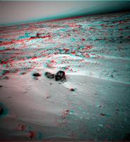
 The Poet Dude Group: Moderator Posts: 5551 Joined: 15-March 04 From: Kendal, Cumbria, UK Member No.: 60 |
This 3D view really shows, I think, the rugged nature of area of the floor of Gale Crater where Curiosity is now...
-------------------- |
|
|
|
|
|
|
Nov 18 2012, 09:10 PM
Post
#474
|
|
|
Solar System Cartographer Group: Members Posts: 10150 Joined: 5-April 05 From: Canada Member No.: 227 |
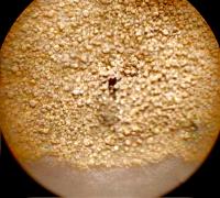
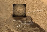
Question - if you look at Navcam images of the scoop area, there are several little dark spots in a cluster just across the top of the drift from the scoops. They were there on sol 84 but not on sol 74. I'm not sure if they are ChemCam laser holes or spots where bits of debris fell out of the scoop. I don't see ChemCam images which look like they are of this area. Any ideas?
Phil -------------------- ... because the Solar System ain't gonna map itself.
Also to be found posting similar content on https://mastodon.social/@PhilStooke NOTE: everything created by me which I post on UMSF is considered to be in the public domain (NOT CC, public domain) |
|
|
|
|
Nov 18 2012, 10:27 PM
Post
#475
|
|||
 Member Group: Members Posts: 215 Joined: 23-October 12 From: Russia Member No.: 6725 |
Here that found. Chem Cam on sol 79
upd: I think, from below - a pebble trace.
Attached thumbnail(s)
-------------------- My blog on Patreon
|
||
|
|
|
||
|
Nov 19 2012, 08:06 AM
Post
#476
|
||
|
Member Group: Members Posts: 215 Joined: 23-October 12 From: Russia Member No.: 6725 |
It is great! Earlier than on an official site?
 Interestingly changes of a dust in a trace.
Attached thumbnail(s)
-------------------- My blog on Patreon
|
|
|
|
|
|
|
Nov 19 2012, 02:36 PM
Post
#477
|
||
|
Solar System Cartographer Group: Members Posts: 10150 Joined: 5-April 05 From: Canada Member No.: 227 |
... and a circular version of that panorama - right on the edge of the good stuff.
Phil
-------------------- ... because the Solar System ain't gonna map itself.
Also to be found posting similar content on https://mastodon.social/@PhilStooke NOTE: everything created by me which I post on UMSF is considered to be in the public domain (NOT CC, public domain) |
|
|
|
|
|
|
Nov 19 2012, 08:12 PM
Post
#478
|
||
|
Member Group: Members Posts: 215 Joined: 23-October 12 From: Russia Member No.: 6725 |
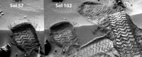
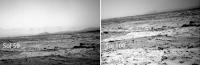
Wow! Probably there was a small dust storm on sol 100.
Attached thumbnail(s)
-------------------- My blog on Patreon
|
|
|
|
|
|
|
Nov 19 2012, 08:26 PM
Post
#479
|
|
|
Founder Group: Chairman Posts: 14431 Joined: 8-February 04 Member No.: 1 |
Unlikely - it's just terrain seen at a different time of day at a different angle. You're not accounting for the autonomous stretching done to the image.
|
|
|
|
|
Nov 19 2012, 08:49 PM
Post
#480
|
|
|
Senior Member Group: Members Posts: 1619 Joined: 12-February 06 From: Bergerac - FR Member No.: 678 |
I will add that it's just a variation of the atmospheric opacity. But there's no dust storm here.
-------------------- |
|
|
|
|

|
Lo-Fi Version | Time is now: 23rd April 2024 - 09:29 PM |
|
RULES AND GUIDELINES Please read the Forum Rules and Guidelines before posting. IMAGE COPYRIGHT |
OPINIONS AND MODERATION Opinions expressed on UnmannedSpaceflight.com are those of the individual posters and do not necessarily reflect the opinions of UnmannedSpaceflight.com or The Planetary Society. The all-volunteer UnmannedSpaceflight.com moderation team is wholly independent of The Planetary Society. The Planetary Society has no influence over decisions made by the UnmannedSpaceflight.com moderators. |
SUPPORT THE FORUM Unmannedspaceflight.com is funded by the Planetary Society. Please consider supporting our work and many other projects by donating to the Society or becoming a member. |
|