Whole Earth images, Does any satellite provide regularly updated ones? |

  |
Whole Earth images, Does any satellite provide regularly updated ones? |
 Mar 8 2007, 04:17 PM Mar 8 2007, 04:17 PM
Post
#1
|
|
 Administrator  Group: Admin Posts: 5172 Joined: 4-August 05 From: Pasadena, CA, USA, Earth Member No.: 454 |
There are tons of Earth observing satellites producing gorgeous detailed images, but I'm trying to figure out if any of them is capable of producing full-globe images of Earth on some regularly updated basis. Does anyone here know of such a beast? Are there weather monitoring satellites that do this?
--Emily -------------------- My website - My Patreon - @elakdawalla on Twitter - Please support unmannedspaceflight.com by donating here.
|
 |
 
|
|
Mar 8 2007, 04:32 PM
Post
#2
|
||
|
Founder Group: Chairman Posts: 14432 Joined: 8-February 04 Member No.: 1 |
Well - there's Meteosat, the European geostationary effort - but that's just one side of said globe. The latest version of Meteosat is the second generation vehicle ( MSG ) which is producing good imagery at high res, every 6 hours. Of course that means basically one full colour image over 0 degrees per day ( the 0600 and 1800 images are, of course, half dark )
Proper website is www.eumetsat.de ( might have seen signposts for Eumetsat on the way into Darmstadt on the Bus - just opposite ESOC ) I'd recommend here - http://www.sat.dundee.ac.uk - (free reg required for good stuff) for regular full res MSG imagery as well as from other, not quite so high-res or full colour etc sats. (i.e. GOESE, GOESW, IODC, MTSAT). TECHNICALLY...one could take these multiple geostationary views, and fudge some sort of global view from them. Also - Aqua and Terra each with my favorite polar orbiting instrument MODIS, do technically cover the entire glove at about 500m/pixel, in colour, at about 1200 and 1400 LOCAL time every day - but I don't believe they produce a daily global product, just the swathes in near real time and a lot of near realtime subset that are reprojected - http://rapidfire.sci.gsfc.nasa.gov/ I guess it depends on what you mean by global. Doug
Attached thumbnail(s)
|
|
|
|
|
|
|
Mar 8 2007, 04:39 PM
Post
#3
|
|
 Senior Member Group: Moderator Posts: 2785 Joined: 10-November 06 From: Pasadena, CA Member No.: 1345 |
This will get you the "other" side of the globe. (click on the type of view and you'll get the full disk)
http://www.goes.noaa.gov/goesfull.html And this will get you a full globe snapshot. (The rotating globe movie is waaaaaay cool-o!) http://www.ssec.wisc.edu/data/composites.html -Mike -------------------- Some higher resolution images available at my photostream: http://www.flickr.com/photos/31678681@N07/
|
|
|
|
|
Mar 8 2007, 04:40 PM
Post
#4
|
|
|
Senior Member Group: Members Posts: 1583 Joined: 14-October 05 From: Vermont Member No.: 530 |
You'd have to be pretty far out there to fit the whole globe in one frame, no?
The NOAA whole-earth water vapor movies are fantastic... neat eddies. |
|
|
|
|
Mar 8 2007, 04:44 PM
Post
#5
|
|
|
Junior Member Group: Members Posts: 22 Joined: 3-January 07 Member No.: 1551 |
I think you could get full-globe images by combining pictures from multiple weather satellites, but obviously you get no more than a hemisphere from anything in GEO. Earth is (if I've done my sums right) 20 degrees across from GEO, so you need some sort of scanning platform to take your detector across Earth.
Ah, this is already done: http://www.ghcc.msfc.nasa.gov/GOES/globalwv.html has global images composed from GOES-EAST (over Peru), GOES-WEST (over the Pacific), and the two Meteosats over the Bight of Benin and Sri Lanka. I suspect there's a Japanese satellite filling the gap east of India. These don't show the poles very well for geometric reasons, and are monochrome (OK, they're trichrome, but those are 10.8u infra-red, 2u infra-red and visible). The polar Earth-observing satellites (say http://rapidfire.sci.gsfc.nasa.gov/) get any point on Earth every few days, but clouds move fast enough that the pictures will look pretty ugly and not line up. |
|
|
|
|
Mar 8 2007, 04:46 PM
Post
#6
|
|
 Interplanetary Dumpster Diver Group: Admin Posts: 4404 Joined: 17-February 04 From: Powell, TN Member No.: 33 |
Modis covers the entire earth every one to two days, depending on how the Aqua and Terra ground tracks fall. This page has some good stuff http://visibleearth.nasa.gov/view_rec.php?id=2429
Seawifs also gets nearly full coverage on a daily basis. -------------------- |
|
|
|
|
Mar 8 2007, 04:47 PM
Post
#7
|
||
|
Founder Group: Chairman Posts: 14432 Joined: 8-February 04 Member No.: 1 |
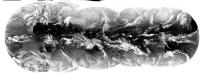
Thought I would see just how hard it is to merge all the GEO MET IR imagery into one strip.....and the answer...with photoshop..is 'suprisingly hard'
Attached thumbnail(s)
|
|
|
|
|
|
|
Mar 8 2007, 04:47 PM
Post
#8
|
|
|
Interplanetary Dumpster Diver Group: Admin Posts: 4404 Joined: 17-February 04 From: Powell, TN Member No.: 33 |
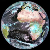
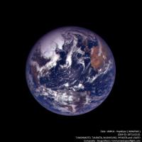
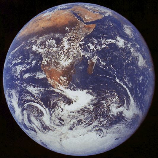
On second thought, Emily, you are breaking the law which states that the only global image of the earth is this one:
-------------------- |
|
|
|
|
Mar 8 2007, 04:49 PM
Post
#9
|
|
|
Administrator Group: Admin Posts: 5172 Joined: 4-August 05 From: Pasadena, CA, USA, Earth Member No.: 454 |
 I'm asking this question on behalf of Lou, and I think what he really means by "global" is "looks like a globe" -- but then he probably wants to see the whole planet too. I'll have to find out what he really wants. --Emily -------------------- My website - My Patreon - @elakdawalla on Twitter - Please support unmannedspaceflight.com by donating here.
|
|
|
|
|
Mar 8 2007, 04:53 PM
Post
#10
|
|
|
Founder Group: Chairman Posts: 14432 Joined: 8-February 04 Member No.: 1 |
Again...TEEEeeechnnically - one could take one of those global composites, reproject it as a texture in realtime and render out a globe-like sphere. But that's way beyond my talents (one offs, yeah, automated every few hours...pah)
Alternatively, who's got a few hundred million to launch Triana? Doug |
|
|
|
|
Mar 8 2007, 05:16 PM
Post
#11
|
|
|
Interplanetary Dumpster Diver Group: Admin Posts: 4404 Joined: 17-February 04 From: Powell, TN Member No.: 33 |
I want to make a comment here, but I can't without being political, so I won't. But the link I gave in the post before my last one definitely has globe-like images.
-------------------- |
|
|
|
|
Mar 8 2007, 05:18 PM
Post
#12
|
|
 Dublin Correspondent Group: Admin Posts: 1799 Joined: 28-March 05 From: Celbridge, Ireland Member No.: 220 |
QUOTE ... the only global image of the earth is this one: Hey - I can see my old house in that.
|
|
|
|
|
Mar 8 2007, 10:25 PM
Post
#13
|
|
|
Senior Member Group: Members Posts: 3516 Joined: 4-November 05 From: North Wales Member No.: 542 |
QUOTE (djellison @ Mar 8 2007, 04:47 PM)  Thought I would see just how hard it is to merge all the GEO MET IR imagery into one strip That is just amazing, Doug. What a thing to think of doing! |
|
|
|
|
Mar 9 2007, 01:53 AM
Post
#14
|
|
 The Insider Group: Members Posts: 669 Joined: 3-May 04 Member No.: 73 |
QUOTE (stevesliva @ Mar 8 2007, 08:40 AM) You'd have to be pretty far out there to fit the whole globe in one frame, no? That reminds me, here's another one...  
|
|
|
|
|
Mar 9 2007, 09:39 AM
Post
#15
|
||
|
Senior Member Group: Members Posts: 2920 Joined: 14-February 06 From: Very close to the Pyrénées Mountains (France) Member No.: 682 |
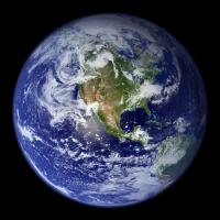
This is one of the more inspiring Earth image to me.
You can see city's lights on the dark side while others are still seeing the sun :
-------------------- |
|
|
|
|
|
|
Mar 9 2007, 10:22 AM
Post
#16
|
|
|
Rover Driver Group: Members Posts: 1015 Joined: 4-March 04 Member No.: 47 |
a shame it's not a real image. Would be nice to see the bottom of the oceans and no clouds at all in the entire world!
|
|
|
|
|
Mar 9 2007, 04:25 PM
Post
#17
|
|
|
Senior Member Group: Moderator Posts: 2785 Joined: 10-November 06 From: Pasadena, CA Member No.: 1345 |
I wonder if one could see the shadow resulting from the March 19th eclipse in the visible image on the Meteosat or GOES web pages?
Pity they aren't "live" webcams! -------------------- Some higher resolution images available at my photostream: http://www.flickr.com/photos/31678681@N07/
|
|
|
|
|
Mar 9 2007, 04:35 PM
Post
#18
|
|
|
Rover Driver Group: Members Posts: 1015 Joined: 4-March 04 Member No.: 47 |
ISS sure had a good look: e.g.
http://www.nasa.gov/vision/universe/solars...rthday2006.html edit - I'm sure I've seen an animation of the moon's shadow moving across the earth, but can't find it right now. pretty: http://sunearthday.nasa.gov/2006/multimedia/gal_011.php |
|
|
|
|
Mar 9 2007, 06:51 PM
Post
#19
|
|
|
Senior Member Group: Moderator Posts: 2785 Joined: 10-November 06 From: Pasadena, CA Member No.: 1345 |
Very cool! I hadn't seen that before. Thanks, remcook!
-Mike -------------------- Some higher resolution images available at my photostream: http://www.flickr.com/photos/31678681@N07/
|
|
|
|
|
Mar 13 2007, 02:56 PM
Post
#20
|
|
|
Newbie Group: Members Posts: 3 Joined: 12-March 07 From: Pasadena, CA USA Member No.: 1857 |
|
|
|
|
|
Mar 13 2007, 03:08 PM
Post
#21
|
|
|
Newbie Group: Members Posts: 4 Joined: 14-February 07 Member No.: 1720 |
EUMESAT is a geo-stationary satellite with full disc imagery in lots of spectra: http://www.eumetsat.int/Home/Main/Image_Ga...mages/index.htm
but can also be found via the link djellison mentioned I think. There are plenty of full disc images in the Apollo Archive http://www.apolloarchive.com/apollo_gallery.html but they're not exactly modern 
|
|
|
|
|
Apr 21 2007, 11:40 PM
Post
#22
|
|
 Senior Member Group: Members Posts: 1639 Joined: 5-March 05 From: Boulder, CO Member No.: 184 |
For clouds this is one of the things I'm working on at NOAA in connection with the Science On a Sphere project. We do have a 30-min global IR animation (interpolated to 15-min) in real-time using a mosaic from the Aviation Weather Center that I am augmenting with Japan's MTSAT data. The actual time resolution does vary over the globe depending on which satellite(s) are covering the area.
My current goal within this effort is to produce an upgraded 15-min global animation by more directly using the various geosynchronous (and polar orbiting) satellites. This will work best with the Meteosat Second Generation data that I believe would have two satellites with the full 15-min resolution over their respective areas of coverage. Other satellites would be used with appropriate temporal interpolation. The IR mosaics exist in up to 2048x4096 resolution, though for display we sometimes reduce this by half when we wrap the animation around the sphere. -------------------- Steve [ my home page and planetary maps page ]
|
|
|
|
|
Apr 22 2007, 07:52 AM
Post
#23
|
|
|
Senior Member Group: Members Posts: 1870 Joined: 20-February 05 Member No.: 174 |
The fundamental problem is that there are no spacecraft that can usefully image the "whole" earth beyond geostationary orbit. From 22 thousand miles out, they see to a horizon of something like 82 north and south (and the same east and west of the subspacecraft point) It's easy to imagine the view as a hemisphere, but a matched view to something from at or beyond the moon would show the difference.
Somebody should be able to match up geostationary global data to Messenger or the failed Japanese Mars orbiter or some such mission to get a quasi simultaneous match and maybe fake it using global mosaic data to show the geostationary view you'd have directly below the deep space mission. |
|
|
|
|
Apr 22 2007, 09:12 AM
Post
#24
|
||
|
Member Group: Members Posts: 194 Joined: 8-February 04 Member No.: 10 |
I used to make Earth textures from weather sats using images gathered during equinoxes when the lighting would cover the most of the planet. The availability of the high res European and Asian satellite coverage dried up on the GOES page I used to frequent and I gave up. I did manage to make one nice instantaneous Earth image which I colorised (with night lights added), and a days noon lighting global composite. A good 4K texture was just possible from these sources. Below can be seen a sample rendering from this work. I used 'Morph', a nice Mac package from years ago, to warp the images to fit a simple cylindrical projection, adding the poles from other sources.
I later did the same thing to MGS global swaths to make my own Mars albedo maps. Don
|
|
|
|
|
|
|
Apr 22 2007, 02:15 PM
Post
#25
|
|
|
Senior Member Group: Members Posts: 1639 Joined: 5-March 05 From: Boulder, CO Member No.: 184 |
Greetings,
I can show a somewhat dated example of the animation I'm working on at this URL. The current animation has an improved blending and colorizing scheme. http://sos.noaa.gov/datasets/Atmosphere/grayscaleIR.html Edstrick - I think the geostationary satellites see up to about 72 degrees latitude. There are an increasing number of polar orbiting satellites that would image the poles with a reasonable frequency if you take them all together. -------------------- Steve [ my home page and planetary maps page ]
|
|
|
|
|
Apr 22 2007, 02:24 PM
Post
#26
|
|
|
Dublin Correspondent Group: Admin Posts: 1799 Joined: 28-March 05 From: Celbridge, Ireland Member No.: 220 |
Steve that is stunning.
Will the newer version be made public? |
|
|
|
|
Apr 22 2007, 03:03 PM
Post
#27
|
|
|
Member Group: Members Posts: 194 Joined: 8-February 04 Member No.: 10 |
In a recent update to my Earth texture I added gas flares to the night lights, but data on where the flaring takes place seems elusive. National Geographic had some flare locations shown in their recent world map so I used a lot of those, and whatever Middle East, Nigeria, and Canada flare images I could find. Does anyone know of a world map showing current gas flaring?
Don |
|
|
|
|
Apr 22 2007, 03:23 PM
Post
#28
|
|
|
Senior Member Group: Members Posts: 1639 Joined: 5-March 05 From: Boulder, CO Member No.: 184 |
Helvick - glad the animation played OK for you. It is a good question about whether this can be made public. You can see it at the dozen or so museums and such that have the SOS exhibit installed. In terms of having it online in real-time this is a bit different category compared with the single frame planetary maps I work on. There are various proprietary, bandwidth, or simply inertia and political issues that might stand in the way here unfortunately. One example is that EUMETSAT charges a significant amount for their high-resolution data. You're welcome to contact the "powers that be" to add your voice to this question. I suppose that the 5MB compressed animation that is on the SOS website could technically be updated in real-time.
By the way, the upper animation on the page looks to be the current colorization I'm using and the lower one is the older one we're phasing out. Although this is a little frustrating I am hoping to share with everyone what could be possible. -------------------- Steve [ my home page and planetary maps page ]
|
|
|
|
|
Apr 24 2007, 09:21 AM
Post
#29
|
|
|
Senior Member Group: Members Posts: 1870 Joined: 20-February 05 Member No.: 174 |
"...I think the geostationary satellites see up to about 72 degrees latitude...." Yes, that sounds right.
My favorite full-disc (or nearly) images of Earth are from Apollo 4, where an automated film camera filled a film magazine with images looking out a window at a fattish crescent Earth. Some are partially cut off by camera field of view or the window-frame. It should be quite possible to work those up into a pretty spectacular high-resolution (scanned film) movie like sequence showing a little Earth rotation/spacecraft-motion/illumination shift during the sequence. I have no idea long the sequence took but I'm sure (I'm sure I hope...) the data is online. My other fav sequence is 2 image sequences from Surveyor 7 on the rim of Tycho. The Earth was low enough in the sky to be visible in the narrow angle camera view. They took 1 image sequence per day, probably through all polarizing filter positions (no color filters on the later Surveyors) showing Earth over a range of phase angles around 180 deg phase (1 day skipped?) They also took a series of images every ?hour? on one day near the end of the mission showing a decent Earth rotation sequence of a gibbous Earth. A bit of image mapping onto a sphere to make a global map and remapping to the spacecraft view of the Earth could make a decent movie. |
|
|
|
|
Apr 27 2007, 12:46 AM
Post
#30
|
|
|
Newbie Group: Members Posts: 3 Joined: 13-March 07 Member No.: 1862 |
WOW those are just incredable images of the Earth, expecially the first one from djellison. Keep uo the great work. This is a great forum.
-------------------- check out my collection at Illinoismeteorites.com
Visit my Meteorite forum at Illinoismeteorites.com/yabb/YaBB.pl |
|
|
|
|
Apr 27 2007, 07:31 AM
Post
#31
|
||
|
Founder Group: Chairman Posts: 14432 Joined: 8-February 04 Member No.: 1 |
Just to fill up this thread appropriately - from the newly released Hayabusa data
Attached thumbnail(s)
|
|
|
|
|
|
|
May 2 2007, 12:00 PM
Post
#32
|
|
|
Member Group: Members Posts: 813 Joined: 29-December 05 From: NE Oh, USA Member No.: 627 |
WOW..
These whole Earth images from departing and returning space craft are particulary evocative to me. I remember Apollo 8 transmissions in 1968. Could actually see the Earth receding. Hayabusa has had quite a journey and I hope there will be a return image. Craig |
|
|
|
|
May 2 2007, 04:10 PM
Post
#33
|
|
|
Administrator Group: Admin Posts: 5172 Joined: 4-August 05 From: Pasadena, CA, USA, Earth Member No.: 454 |
I totally forgot to return to this thread after creating some pages on the topic. Thanks, everybody, for your suggestions. Here's the two pages I've put together so far:
Images of Earth from Geostationary Satellites Images of Earth from Planetary Spacecraft I still need to add the Hayabusa images, and I know Doug's got a few more pieces of eye candy in production... --Emily -------------------- My website - My Patreon - @elakdawalla on Twitter - Please support unmannedspaceflight.com by donating here.
|
|
|
|
|
May 2 2007, 06:10 PM
Post
#34
|
|
 Senior Member Group: Members Posts: 1281 Joined: 18-December 04 From: San Diego, CA Member No.: 124 |
Nice collection, Emily.
I keep forgetting there's a whole sidebar on the left of the Planetary Society Website to explore.... though I can't even keep up with your blog updates!
-------------------- Lyford Rome
"Zis is not nuts, zis is super-nuts!" Mathematician Richard Courant on viewing an Orion test |
|
|
|
|
May 5 2007, 02:51 PM
Post
#35
|
|
|
Senior Member Group: Members Posts: 1639 Joined: 5-March 05 From: Boulder, CO Member No.: 184 |
Yes - excellent website Emily. Nice summary of the various geostationary satellites - helps me keep track of them as I contemplate further work on high frequency global animations.
I also like the images with the Earth and moon in the same frame, we live on such a colorful and vibrant planet. -------------------- Steve [ my home page and planetary maps page ]
|
|
|
|
|
May 9 2007, 07:21 AM
Post
#36
|
|
|
Founder Group: Chairman Posts: 14432 Joined: 8-February 04 Member No.: 1 |
The page has been updated with my Galileo efforts
That Earth 1 flyby I've only ever seen as a tiny .mov or .mpg - so I had a hack at it - every 4th(ish) frame - at full res. Quite pleased with the results. While doing that, I also found an Earth-Moon conjunction observation from the Earth 2 flyby that is very Cassini-esque The Earth 2 flyby data is, on the whole, ruined by dropouts for some reason - truely tragic as it would have been spectacular !! |
|
|
|
|
May 9 2007, 12:43 PM
Post
#37
|
|
|
Solar System Cartographer Group: Members Posts: 10164 Joined: 5-April 05 From: Canada Member No.: 227 |
Don't forget Lunar Orbiter, Surveyor and the Zonds. There are several Earth images to be found among those datasets.
Phil -------------------- ... because the Solar System ain't gonna map itself.
Also to be found posting similar content on https://mastodon.social/@PhilStooke Maps for download (free PD: https://upload.wikimedia.org/wikipedia/comm...Cartography.pdf NOTE: everything created by me which I post on UMSF is considered to be in the public domain (NOT CC, public domain) |
|
|
|
|
May 9 2007, 01:10 PM
Post
#38
|
|
|
Senior Member Group: Members Posts: 2454 Joined: 8-July 05 From: NGC 5907 Member No.: 430 |
The Japanese Mars probe Nozomi also took images of Earth and Luna,
which you can see here: http://www.stp.isas.jaxa.jp/nozomi/MIC/MIC_e.html -------------------- "After having some business dealings with men, I am occasionally chagrined,
and feel as if I had done some wrong, and it is hard to forget the ugly circumstance. I see that such intercourse long continued would make one thoroughly prosaic, hard, and coarse. But the longest intercourse with Nature, though in her rudest moods, does not thus harden and make coarse. A hard, sensible man whom we liken to a rock is indeed much harder than a rock. From hard, coarse, insensible men with whom I have no sympathy, I go to commune with the rocks, whose hearts are comparatively soft." - Henry David Thoreau, November 15, 1853 |
|
|
|
| Guest_AlexBlackwell_* |
May 9 2007, 09:52 PM
Post
#39
|
|
Guests |
|
|
|
|
|
May 10 2007, 01:36 PM
Post
#40
|
|
|
Founder Group: Chairman Posts: 14432 Joined: 8-February 04 Member No.: 1 |
I plan to do to NEAR what I've done to the Galileo E1 flyby - but I think there might be something a bit broken with NEAR MSI FITS and img2png - and I'm not even going to attempt it if I have to load each frame individually
As with the Galileo flybys, I've only really seen them put together as a movie at low res. The reason I did the Galileo one was to see it at the full res - and I think the effort was worth it. Doug |
|
|
|
|
May 11 2007, 01:40 PM
Post
#41
|
|
|
Interplanetary Dumpster Diver Group: Admin Posts: 4404 Joined: 17-February 04 From: Powell, TN Member No.: 33 |
Great Galileo work, Doug.
By the way, there are several Zond images. The USGS site has quite a few from Zond-8. Zond 7 took a color earthrise sequence. Quite a few of the frames are in my collection and all over the internet, but the color quality is poor (presumably due to poor copying, based on small samples of better copies I have seen. Here is a sequence, showing what I have been able to cobble together from multiple frames, croping out areas I couldn't generate for all images. Click on this link for a larger version.  http://www.strykfoto.org/zondrise.jpg -------------------- |
|
|
|
|
May 11 2007, 01:54 PM
Post
#42
|
|
 Senior Member Group: Members Posts: 3648 Joined: 1-October 05 From: Croatia Member No.: 523 |
Wow, awesome, Ted!
-------------------- |
|
|
|
|
May 14 2007, 11:54 AM
Post
#43
|
|
|
Senior Member Group: Members Posts: 3648 Joined: 1-October 05 From: Croatia Member No.: 523 |
I see Doug's Galileo Earth rotation made APOD today, congrats!
I was browsing through the rotation sequence raws myself and something struck me as interesting. There's a few frames that exhibit a bright glint-like speck somewhere above Argentina. It's visible in several different filter frames and it's not camera-related as it's fixed to Earth in subsequent frames though the glint appears to move slightly along the groundtrack. It's much brighter than the rest of the cloud structure visible so I was wondering if anyone has any theories? It can be seen as a green-red charge bleed in this composite:  The brightness difference between the speck and the rest of the clouds is much lower here due to the processing than it is in the original frames. -------------------- |
|
|
|
|
May 14 2007, 01:31 PM
Post
#44
|
|
|
Founder Group: Chairman Posts: 14432 Joined: 8-February 04 Member No.: 1 |
It's a specular reflection off a lake in Uraguay or Argentina I think - if you run through all the images you can see it very very clearly.(when I say all, I mean every image, i.e. r, ir, g, ir, v..etc etc)
Just guessing - but my initial thoughts were that rough oceans with large amplitude waves dont produce a pin sharp specular reflection from the sun. A small lake - which could be almost totally flat - would produce a sharp specular highlight. APOD - Sweet - I had no idea  Doug |
|
|
|
|
May 14 2007, 01:39 PM
Post
#45
|
|
|
Senior Member Group: Members Posts: 3648 Joined: 1-October 05 From: Croatia Member No.: 523 |
I thought about a lake specular, the specular point is in about the right location, but the area seemed to be clouded over to actually see a lake. If it's actually a lake, it's great to see how much brighter speculars on a flat surface are than oceanic specular "point". As the specular point is tighter when the surface is less rough it goes to show what a cool coincidence this turned out to be.
Imagine seeing something of the sort on Titan... -------------------- |
|
|
|
|
May 14 2007, 02:08 PM
Post
#46
|
|
|
Interplanetary Dumpster Diver Group: Admin Posts: 4404 Joined: 17-February 04 From: Powell, TN Member No.: 33 |
Emily, you are welcome to add this to the planetary society page, but remember the version I linked to is larger.
-------------------- |
|
|
|
|
May 14 2007, 02:18 PM
Post
#47
|
|
|
Founder Group: Chairman Posts: 14432 Joined: 8-February 04 Member No.: 1 |
It's not packed solid cloud though - it's bitty, hazy perhaps -not full on blanket covering. Certainly enough to let the reflection through
Doug |
|
|
|
|
May 14 2007, 03:00 PM
Post
#48
|
|
|
Administrator Group: Admin Posts: 5172 Joined: 4-August 05 From: Pasadena, CA, USA, Earth Member No.: 454 |
QUOTE (tedstryk @ May 14 2007, 07:08 AM) Emily, you are welcome to add this to the planetary society page, but remember the version I linked to is larger. Thanks, Ted! I've been out of town for a few days, so a bit out of the loop, but I'll be back home tonight and will DEFINITELY add your cool Zond images to the site. And congrats on APOD, Doug! --Emily -------------------- My website - My Patreon - @elakdawalla on Twitter - Please support unmannedspaceflight.com by donating here.
|
|
|
|
|
May 14 2007, 03:23 PM
Post
#49
|
|
|
Solar System Cartographer Group: Members Posts: 10164 Joined: 5-April 05 From: Canada Member No.: 227 |
Just to clarify one point, Ted's Earthrise is actually an Earthset. So is the famous Lunar Orbiter 1 view of Earth over the lunar horizon. Only Apollo (among those early missions) saw the Earth rise.
Phil -------------------- ... because the Solar System ain't gonna map itself.
Also to be found posting similar content on https://mastodon.social/@PhilStooke Maps for download (free PD: https://upload.wikimedia.org/wikipedia/comm...Cartography.pdf NOTE: everything created by me which I post on UMSF is considered to be in the public domain (NOT CC, public domain) |
|
|
|
|
May 14 2007, 03:47 PM
Post
#50
|
|
|
Interplanetary Dumpster Diver Group: Admin Posts: 4404 Joined: 17-February 04 From: Powell, TN Member No.: 33 |
Doug: Congratulations!
Phil: I had no idea. The images come from a variety of sources, and I ordered them without even considering that it might be an earthset! -------------------- |
|
|
|
|
May 14 2007, 03:58 PM
Post
#51
|
|
|
Interplanetary Dumpster Diver Group: Admin Posts: 4404 Joined: 17-February 04 From: Powell, TN Member No.: 33 |
-------------------- |
|
|
|
|
May 27 2007, 01:40 AM
Post
#52
|
|
|
Member Group: Members Posts: 194 Joined: 8-February 04 Member No.: 10 |
In images 2 and 4 of the Zond sequence the Lunar horizon part of the photos are identical with no perspective change as one would expect from an actual orbital sequence. Only three of the images are thus part of a valid sequence.
I would love to have a full res color version of the 'Earthset' Zond image TASS released in B&W, which I saw and photographed at the Hansen Planetarium when I worked there. Don |
|
|
|
|
May 27 2007, 02:00 AM
Post
#53
|
|
|
Interplanetary Dumpster Diver Group: Admin Posts: 4404 Joined: 17-February 04 From: Powell, TN Member No.: 33 |
It is actually image 2 that isn't a valid part of the sequence - I created it using image one and three in order to even up the time intervals.
-------------------- |
|
|
|
|
Jul 20 2007, 01:26 PM
Post
#54
|
|
 Senior Member Group: Members Posts: 1619 Joined: 12-February 06 From: Bergerac - FR Member No.: 678 |
It's not a whole Earth picture but it's of topicality (dust on Mars... dust on Earth) :
http://www.studiolentigo.net/upload/Poussi...ill2007-18h.jpg (taken yesterday à 6 A.M by MSG2) -------------------- |
|
|
|
|
Jul 20 2007, 07:27 PM
Post
#55
|
|
|
Senior Member Group: Members Posts: 2920 Joined: 14-February 06 From: Very close to the Pyrénées Mountains (France) Member No.: 682 |
QUOTE (Ant103 @ Jul 20 2007, 03:26 PM) It's not a whole Earth picture but it's of topicality (dust on Mars... dust on Earth) : il marche pas le lien  
-------------------- |
|
|
|
|
Jul 20 2007, 08:53 PM
Post
#56
|
|
 Member Group: Members Posts: 146 Joined: 23-August 06 From: Vriezenveen, Netherlands Member No.: 1067 |
this link works
|
|
|
|
|
Jul 23 2007, 04:51 PM
Post
#57
|
||
|
Newbie Group: Members Posts: 17 Joined: 6-July 07 Member No.: 2698 |
This is one of my favorites, it makes a great wallpaper on your computer.
Attached thumbnail(s)
|
|
|
|
|
|
|
Jul 23 2007, 08:37 PM
Post
#58
|
|
|
Founder Group: Chairman Posts: 14432 Joined: 8-February 04 Member No.: 1 |
That's just renered from the Blue Marble data set. Nice - but not real
Doug |
|
|
|
|
Jul 23 2007, 11:13 PM
Post
#59
|
|
 Junior Member Group: Members Posts: 76 Joined: 4-June 07 From: United Kingdom Member No.: 2288 |
The Japanese GMS-5 satellite used to produce full disc images every half an hour. By the time I managed to construct a rather rough animation of full disc cloud movements their camera was failing (as you can see in the following animation).
 (Click for larger) mouseonmars -------------------- |
|
|
|
|
Oct 9 2007, 03:16 PM
Post
#60
|
|
|
Senior Member Group: Members Posts: 1639 Joined: 5-March 05 From: Boulder, CO Member No.: 184 |
Hi - there are a few images collected by NASA at this link:
http://eol.jsc.nasa.gov/scripts/sseop/Phot...l?set=EarthDisc -------------------- Steve [ my home page and planetary maps page ]
|
|
|
|
|
Oct 9 2007, 04:50 PM
Post
#61
|
|
|
Senior Member Group: Members Posts: 3648 Joined: 1-October 05 From: Croatia Member No.: 523 |
Great resource, Steve! Images I hadn't seen before. I only browsed the few images from the Apollo set, but it looks like a gem.
Sadly, the highest resolution versions have too high a compression ratio set and the scans turn weirdly green. I tried to remove the green background. Two nice Apollo 8 shots, reduced in size:   I'm a sucker for those thru-the-window shots or, in general, views which show objects of recognizable size with which a human can relate. Apollo 10 Earthrise, always an awesome sight. So they say... 
-------------------- |
|
|
|
|
Oct 9 2007, 07:59 PM
Post
#62
|
|
|
Junior Member Group: Members Posts: 76 Joined: 4-June 07 From: United Kingdom Member No.: 2288 |
QUOTE (scalbers @ Oct 9 2007, 04:16 PM) Hi - there are a few images collected by NASA at this link: http://eol.jsc.nasa.gov/scripts/sseop/Phot...l?set=EarthDisc Cripes. Thanks scalbers. I found that site ages ago. The highest resolution images of this type I've come across before. Complete with views of the Earth taken out of the Apollo mission ports that I did'nt know about. I then lost the address and no one seemed to know what site I was talking about  . So you get some thanks from my friends . So you get some thanks from my friends  . .MouseOnMars -------------------- |
|
|
|
|
Oct 10 2007, 07:31 PM
Post
#63
|
|
|
Senior Member Group: Members Posts: 2454 Joined: 8-July 05 From: NGC 5907 Member No.: 430 |
-------------------- "After having some business dealings with men, I am occasionally chagrined,
and feel as if I had done some wrong, and it is hard to forget the ugly circumstance. I see that such intercourse long continued would make one thoroughly prosaic, hard, and coarse. But the longest intercourse with Nature, though in her rudest moods, does not thus harden and make coarse. A hard, sensible man whom we liken to a rock is indeed much harder than a rock. From hard, coarse, insensible men with whom I have no sympathy, I go to commune with the rocks, whose hearts are comparatively soft." - Henry David Thoreau, November 15, 1853 |
|
|
|
|
Oct 10 2007, 09:12 PM
Post
#64
|
|
 The Poet Dude Group: Moderator Posts: 5551 Joined: 15-March 04 From: Kendal, Cumbria, UK Member No.: 60 |
Those new Twin Blue Marble images are just spectacularly beautiful, thanks for the link.
Truly an oasis in the dark ocean of space... -------------------- |
|
|
|
|
Oct 10 2007, 10:01 PM
Post
#65
|
|
 Special Cookie Group: Members Posts: 2168 Joined: 6-April 05 From: Sintra | Portugal Member No.: 228 |
QUOTE (Stu @ Oct 10 2007, 10:12 PM) Those new Twin Blue Marble images are just spectacularly beautiful, thanks for the link. Truly an oasis in the dark ocean of space... Yes they are Stu!...Thank you all! All the provided links are true treasures...don't know why, maybe because I had dinner at an indian restaurant nearby, I became all mystical looking at those images and thinking about all the solid ground I have covered with my own feet in this incredbly small and fragile parcel of the Universe...Man!...How priviliged are we?!... -------------------- "Ride, boldly ride," The shade replied, "If you seek for Eldorado!"
Edgar Alan Poe |
|
|
|
|
Oct 22 2007, 08:03 PM
Post
#66
|
||
|
Senior Member Group: Members Posts: 3648 Joined: 1-October 05 From: Croatia Member No.: 523 |
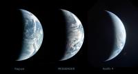
Here's a side-by-side comparison of 3 crescent Earth shots at a similar phase angle. They were all tweaked from what is officially available to make ocean color more similar to each other. From left to right: Kaguya, MESSENGER and Apollo 4. North is up only in Kaguya's image.
-------------------- |
|
|
|
|
|
|
Nov 23 2007, 05:59 PM
Post
#67
|
||
|
Member Group: Members Posts: 140 Joined: 20-November 07 Member No.: 3967 |
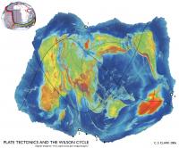
Here is another way to see -- and think about -- the whole globe: with a map, of course. Some of the above posts have been map-like.
This is a constant-scale natural boundary world map of Earth. Its boundary is a portion, the Atlantic Ocean portion, of the mid-ocean ridge. You might, if you want, follow along with what I learn is called "the Wilson cycle": where the spreading apart of the Atlantic Ocean floor will eventually push closed the Pacific Ocean. That idea, I also hear, is a lot of simplistic, anthropomorphic bunkum. I don't mean to take sides in any argument here, just to point out that with a little ingenuity world maps may be fashioned to illustrate ideas global in scope. Something meant to address climate change, to reveal large scale patterns in meteorology, a CSNB world map edged by continental divides, for example, would look entirely different. I'm new around here, and have only recently looked through the "new" rules. It's hard to imagine how this string of posts relates to unmanned space flight. But given the drift of this conversation, I just wanted to add this to the discussion of whole earth views of ther globe.
Attached thumbnail(s)
|
|
|
|
|
|
|
Nov 25 2007, 06:49 AM
Post
#68
|
||
|
Junior Member Group: Members Posts: 73 Joined: 25-June 07 From: United States Member No.: 2537 |
This is one of my favorites.
|
|
|
|
|
|
|
Nov 25 2007, 05:53 PM
Post
#69
|
||
 Senior Member Group: Members Posts: 2492 Joined: 15-January 05 From: center Italy Member No.: 150 |
Cool picture, n1ckdrake! Which source/mission? Apollo?
Herebelow an improved crop I made (in particular, color/contrast adjust and sharpening)... I think is a perfect wallpaper! 
-------------------- I always think before posting! - Marco -
|
|
|
|
|
|
|
Nov 25 2007, 06:50 PM
Post
#70
|
|
 Senior Member Group: Members Posts: 1729 Joined: 3-August 06 From: 43° 35' 53" N 1° 26' 35" E Member No.: 1004 |
QUOTE (dilo @ Nov 25 2007, 06:53 PM) Cool picture, n1ckdrake! very cool indeed, and dilo and me we are almost right at the center of it!
|
|
|
|
|
Nov 25 2007, 08:00 PM
Post
#71
|
|
|
Rover Driver Group: Members Posts: 1015 Joined: 4-March 04 Member No.: 47 |
oeee is that a Kelvin wave? Cool!
|
|
|
|
|
Nov 26 2007, 03:27 AM
Post
#72
|
|
|
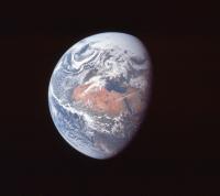
Junior Member Group: Members Posts: 73 Joined: 25-June 07 From: United States Member No.: 2537 |
The photo of the Earth is from the Apollo 10 mission, taken at a distance of 100,000 nautical miles. Here is the link to the Apollo 10 Earth Photo
|
|
|
|
|
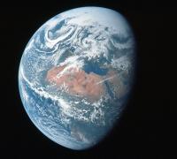
Nov 26 2007, 04:10 AM
Post
#73
|
|
|
Junior Member Group: Members Posts: 73 Joined: 25-June 07 From: United States Member No.: 2537 |
|
|
|
|
|
Nov 26 2007, 05:17 AM
Post
#74
|
|
 Senior Member Group: Members Posts: 3419 Joined: 9-February 04 From: Minneapolis, MN, USA Member No.: 15 |
QUOTE (n1ckdrake @ Nov 25 2007, 09:27 PM) The photo of the Earth is from the Apollo 10 mission, taken at a distance of 100,000 nautical miles. I knew it had to be from one of three missions -- Apollos 10, 11 or 15 -- due to the amount of the North Pole illuminated by the Sun. Since we appeared to be further from solstice than July, my best guess was Apollo 10 (which, of course, flew in May). Nice to see I was right! -the other Doug -------------------- The trouble ain't that there is too many fools, but that the lightning ain't distributed right. -Mark Twain
|
|
|
|
|
Nov 26 2007, 05:20 AM
Post
#75
|
|
|
Senior Member Group: Members Posts: 3419 Joined: 9-February 04 From: Minneapolis, MN, USA Member No.: 15 |
QUOTE (n1ckdrake @ Nov 25 2007, 10:10 PM) This image is from the Apollo 16 mission. This view is almost identical to the view televised from Apollo 16 immediately after transposition and docking, which was by far the best image of global Earth ever transmitted via television from an Apollo spacecraft. -the other Doug -------------------- The trouble ain't that there is too many fools, but that the lightning ain't distributed right. -Mark Twain
|
|
|
|
|
Dec 29 2007, 04:04 PM
Post
#76
|
||
 Member Group: Members Posts: 568 Joined: 20-April 05 From: Silesia Member No.: 299 |
This image is from the Mariner-10 spacecraft.
Image FDS0014553 (November 1973) -------------------- Free software for planetary science (including Cassini Image Viewer).
http://members.tripod.com/petermasek/marinerall.html |
|
|
|
|
|
|
Feb 5 2008, 02:59 PM
Post
#77
|
|
|
Senior Member Group: Members Posts: 3648 Joined: 1-October 05 From: Croatia Member No.: 523 |
Here's a montage of Earth and Moon from MESSENGER. I used both the blue and violet filters for Earth because they're fairly narrowband and the violet filter better captures the Rayleigh scattering effect of the atmosphere than the longer wavelength blue. The Moon is a narrow-angle image taken a couple of days earlier and colorized using much lower resolution wide-angle data.
Earth is presented in a gamma-correct version so the contrast is different than in the official release. Earth's color balance is based on recent digital imagery from the Shuttle/ISS missions. I'm always striving to improve Earth's color in my images, this is currently my best guess and I'm fairly pleased with how it turned out. 
-------------------- |
|
|
|
|
Feb 5 2008, 03:23 PM
Post
#78
|
|
|
The Poet Dude Group: Moderator Posts: 5551 Joined: 15-March 04 From: Kendal, Cumbria, UK Member No.: 60 |
Oh my....
"Beautiful" doesn't even begin to do that justice. Can't help wondering what it will be like for the astronauts of the future, to see that view through their spaceship window as they come home after a mission to Mars, or Europa, or to another star... Just magical. -------------------- |
|
|
|
|
Feb 5 2008, 03:24 PM
Post
#79
|
|
|
Founder Group: Chairman Posts: 14432 Joined: 8-February 04 Member No.: 1 |
I wonder if, with the Dawn flyby - we might get a similar view of Mars. We have a recent similar shot of Mercury, and Venus - it'd be great to wrap up a nice inner-solar system family portrait
|
|
|
|
|
Feb 5 2008, 03:41 PM
Post
#80
|
|
|
Senior Member Group: Members Posts: 3648 Joined: 1-October 05 From: Croatia Member No.: 523 |
Now that you mention it, the Mercury image and this one do have almost completely the same phase angles.
Speaking of Mars, I wonder how much longer it's going to be before any Rosetta data hits the PSA (*cough*Mars flyby*cough*)... -------------------- |
|
|
|
|
Feb 5 2008, 03:54 PM
Post
#81
|
|
|
Junior Member Group: Members Posts: 59 Joined: 25-December 05 From: Stevens Point, Wisconsin, USA Member No.: 619 |
Nice picture, ugordan.
Are those smoke plumes from Amazonian forest fires? (I'm referring to the wispy features to the south of the river, not the obvious clouds to the north). If so, it's quite sobering that they could be seen from 10,000's of km away... |
|
|
|
|
Feb 5 2008, 04:12 PM
Post
#82
|
|
|
Senior Member Group: Members Posts: 1074 Joined: 21-September 07 From: Québec, Canada Member No.: 3908 |
Very nice image, except the Moon is not in its correct orientation. We can see features invisible from Earth, namely Mare Orientale and part of the farside
|
|
|
|
|
Feb 5 2008, 04:19 PM
Post
#83
|
|
|
Senior Member Group: Members Posts: 3648 Joined: 1-October 05 From: Croatia Member No.: 523 |
QUOTE (charborob @ Feb 5 2008, 05:12 PM) Very nice image, except the Moon is not in its correct orientation. We can see features invisible from Earth, namely Mare Orientale and part of the farside I said it's a montage, not an exact scene visible from the spacecraft. The Earth-Moon system did not look like this at any single time during the flyby, the phase angle difference makes that pretty obvious. Think of it as "artistic license" - putting the moon "closer" to the source of illumination because it's at a higher phase angle. As to putting the Moon to the left of the planet (at that time it was waaay up and to the left of Earth), I dunno, this looked more aesthetic to me. I didn't want to put the Moon in an inset box either for that reason. Rogelio, I can't tell if those are forest fires or not. The official image advisory doesn't mention them, but I've found a site concerned with forest fires which claims the 2005 year was particularly bad in terms of fires in the Amazon (something about reduced rainfall that season). It does look like smoke, but then again, it could be low haze due to air humidity in the region. It's widespread all the way to the Andes so I'm inclined to say that's indeed smoke. I can't find any GOES-East satellite archive going back to August 2005 to better see what that was. -------------------- |
|
|
|
|
Feb 5 2008, 05:15 PM
Post
#84
|
|
|
Interplanetary Dumpster Diver Group: Admin Posts: 4404 Joined: 17-February 04 From: Powell, TN Member No.: 33 |
Amazing!
-------------------- |
|
|
|
|
Feb 5 2008, 05:42 PM
Post
#85
|
|
|
Senior Member Group: Members Posts: 1619 Joined: 12-February 06 From: Bergerac - FR Member No.: 678 |
Good god
 I've found the desktop wallpaper of the day  . .Thanks .
-------------------- |
|
|
|
|
Feb 5 2008, 06:23 PM
Post
#86
|
|
 Senior Member Group: Members Posts: 2173 Joined: 28-December 04 From: Florida, USA Member No.: 132 |
QUOTE (charborob @ Feb 5 2008, 11:12 AM) Very nice image, except the Moon is not in its correct orientation. We can see features invisible from Earth... But the image is not seen from the Earth's perspective. |
|
|
|
|
Feb 5 2008, 06:28 PM
Post
#87
|
|
|
Rover Driver Group: Members Posts: 1015 Joined: 4-March 04 Member No.: 47 |
amazing work as usual!
|
|
|
|
|
Feb 8 2008, 12:07 PM
Post
#88
|
||
|
Senior Member Group: Moderator Posts: 2785 Joined: 10-November 06 From: Pasadena, CA Member No.: 1345 |
Thank y'all for this thread!
Using these resources I was able to snag an image taken today (February 8, 2008) of three tropical cyclones simultaneously churning in the South Indian Ocean.
(Starting to look like Jupiter down there, isn't it?) This site was used to access this image: http://www.goes.noaa.gov/goesfull.html -Mike -------------------- Some higher resolution images available at my photostream: http://www.flickr.com/photos/31678681@N07/
|
|
|
|
|
|
|
Feb 9 2008, 08:39 AM
Post
#89
|
|
|
The Poet Dude Group: Moderator Posts: 5551 Joined: 15-March 04 From: Kendal, Cumbria, UK Member No.: 60 |
QUOTE (ugordan @ Feb 5 2008, 02:59 PM) Here's a montage of Earth and Moon from MESSENGER. .... I'm always striving to improve Earth's color in my images, this is currently my best guess and I'm fairly pleased with how it turned out. Me too! Thanks for giving me permission to use it, Gordan! "No Place Like Home..." -------------------- |
|
|
|
|
Feb 9 2008, 05:16 PM
Post
#90
|
|
|
Senior Member Group: Members Posts: 3648 Joined: 1-October 05 From: Croatia Member No.: 523 |
You're welcome, Stu!

-------------------- |
|
|
|
|
Jul 6 2008, 08:51 PM
Post
#91
|
||
|
Senior Member Group: Moderator Posts: 2785 Joined: 10-November 06 From: Pasadena, CA Member No.: 1345 |
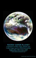
Combination of Water Vapor (primarily), Infrared, and Visible images from the GOES-East geostationary satellite. These images were downloaded from the Dundee Receiving Station website today (images for July 6, 20081500 UTC)
Aqua and blue tones indicates higher levels of water vapor, while maroon tones indicate drier air. In the central Atlantic, Tropical Storm Bertha can be seen leaving a trail of clouds to the east as it pumps water vapor into the atmosphere. -Mike -------------------- Some higher resolution images available at my photostream: http://www.flickr.com/photos/31678681@N07/
|
|
|
|
|
|
|
Jul 6 2008, 08:58 PM
Post
#92
|
|
|
Senior Member Group: Members Posts: 3648 Joined: 1-October 05 From: Croatia Member No.: 523 |
Ooh... funky stuff!
-------------------- |
|
|
|
|
Aug 3 2008, 01:02 AM
Post
#93
|
|
|
Member Group: Members Posts: 194 Joined: 8-February 04 Member No.: 10 |
Thanks to Robert Beal of the John Hopkins Applied Physics Lab, I now have on my site a copy of the first color image of the Earth as a disk. It was made September 20, 1967 by the Department Of Defense Gravity Experiment satellite (DODGE). He worked on the mission, painting the spherical color target at the end of the boom and photographically assembling the color image. Beal sent me a file based on a print he made, which he had color balanced to resemble the ATS Earth image on my site. Upon my request he reconstructed the color scheme of the poorly imaged target from memory. I was told the colors used, similar in philosophy to Surveyor, were radiation resistant paints which happened to be of low saturation. The idea of a spherical color target is interesting, and strikes me as ingenious. If both target and background are sunlit the target can supply useful information at a wide range of lighting angles. Has this method been used in other camera carrying spacecraft?
In a separate version I have repainted the color target, fixing the motion blur in the boom in the blue channel, and tried to 'fine tune' the Autochrome like image into a kind of 'reconstruction' of how it might have appeared if all imaging steps worked ideally. http://www.donaldedavis.com/2003NEW/NEWSTUFF/DDEARTH.html Don |
|
|
|
|
Aug 3 2008, 07:13 AM
Post
#94
|
|
|
The Poet Dude Group: Moderator Posts: 5551 Joined: 15-March 04 From: Kendal, Cumbria, UK Member No.: 60 |
That's quite a coup you have there, well done. I had no idea images like that were being taken so early on. Thanks for sharing it with us here.
-------------------- |
|
|
|
|
Aug 4 2008, 03:50 PM
Post
#95
|
|
 Member Group: Members Posts: 198 Joined: 2-March 05 From: Richmond, VA USA Member No.: 181 |
QUOTE (ugordan @ Feb 5 2008, 12:19 PM) Rogelio, I can't tell if those are forest fires or not. The official image advisory doesn't mention them, but I've found a site concerned with forest fires which claims the 2005 year was particularly bad in terms of fires in the Amazon (something about reduced rainfall that season). It does look like smoke, but then again, it could be low haze due to air humidity in the region. It's widespread all the way to the Andes so I'm inclined to say that's indeed smoke. I can't find any GOES-East satellite archive going back to August 2005 to better see what that was. A bit late but hopefully still helpful.... http://www.ncdc.noaa.gov/gibbs/image/GOE-12/VS/2005-08-02-15 |
|
|
|
|
Aug 21 2008, 02:51 AM
Post
#96
|
||
|
Senior Member Group: Moderator Posts: 2785 Joined: 10-November 06 From: Pasadena, CA Member No.: 1345 |
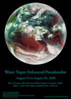
Animated loop of the Atlantic Basin of the Earth from August 10-20, 2008 in Amazing AquaVision (click to launch 1 Mb animated GIF):
Tropical Storm Fay (AKA "The Joker") can be seen pulsing her way into the Florida peninsula. -Mike (I gotta figure how to host the big version somewhere...) -------------------- Some higher resolution images available at my photostream: http://www.flickr.com/photos/31678681@N07/
|
|
|
|
|
|
| Guest_PhilCo126_* |
Aug 21 2008, 06:19 PM
Post
#97
|
|
Guests |
Nice picture, ugordan, Moon orientation a bit too close to Earth... otherwise no remarks

|
|
|
|
|
Aug 21 2008, 07:28 PM
Post
#98
|
|
 Director of Galilean Photography Group: Members Posts: 896 Joined: 15-July 04 From: Austin, TX Member No.: 93 |
Juramike,
The best places for weather discussion I've found is Weather Underground, www.weatherunderground.com. Check out their blogs. -------------------- Space Enthusiast Richard Hendricks
-- "The engineers, as usual, made a tremendous fuss. Again as usual, they did the job in half the time they had dismissed as being absolutely impossible." --Rescue Party, Arthur C Clarke Mother Nature is the final inspector of all quality. |
|
|
|
|
Aug 21 2008, 10:24 PM
Post
#99
|
|
|
Senior Member Group: Moderator Posts: 2785 Joined: 10-November 06 From: Pasadena, CA Member No.: 1345 |
Weather Underground is a great site. I'm a huge fan of the Tropical blog.
The water vapor images of the Earth make our own planet seem so...alien. The overall beltlike appearance in the Water Vapor images of moist zones and dry zones make Earth look much more like Venus (with Earth just having a few more nodes). The things that really piqued my interest in the (tiny) loop above are the clear zones that seems to be forming around and beyond developing warm core tropical systems like Tropical Storm Fay and Invest 94. These dark, dryish surrounding zones seem to actually "push and clear" into the ITCZ. I've just spent a few hours prowling on the web trying to figure what makes these clear zones in the Water Vapor loop (without much luck). The smaller swirls at the edge of Saturn's South Polar Vortex (multispectral imaging in PIA08333) look kinda similar, as if the isolated eddies are "pushing and clearing" into surrounding belts. Are they formed by the same mechanism or totally different? Who knows? It's fascinating how overall similar the structures are. Even the swirling loops around Antarctica look like Earth has it's own South Polar Vortex - just with a more fluid and changing boundary. -Mike -------------------- Some higher resolution images available at my photostream: http://www.flickr.com/photos/31678681@N07/
|
|
|
|
|
Sep 15 2008, 07:33 AM
Post
#100
|
|
 Senior Member Group: Moderator Posts: 2262 Joined: 9-February 04 From: Melbourne - Oz Member No.: 16 |
Images of storms are rather off topic for this thread, i've moved them to a new one:
Storms from Orbit -------------------- |
|
|
|
|

|
Lo-Fi Version | Time is now: 19th May 2024 - 10:15 PM |
|
RULES AND GUIDELINES Please read the Forum Rules and Guidelines before posting. IMAGE COPYRIGHT |
OPINIONS AND MODERATION Opinions expressed on UnmannedSpaceflight.com are those of the individual posters and do not necessarily reflect the opinions of UnmannedSpaceflight.com or The Planetary Society. The all-volunteer UnmannedSpaceflight.com moderation team is wholly independent of The Planetary Society. The Planetary Society has no influence over decisions made by the UnmannedSpaceflight.com moderators. |
SUPPORT THE FORUM Unmannedspaceflight.com is funded by the Planetary Society. Please consider supporting our work and many other projects by donating to the Society or becoming a member. |
|