SpaceIL lunar lander mission - 2019 |

  |
SpaceIL lunar lander mission - 2019 |
 Apr 14 2019, 04:07 AM Apr 14 2019, 04:07 AM
Post
#46
|
||
 Junior Member  Group: Members Posts: 31 Joined: 24-February 17 From: California Member No.: 8127 |
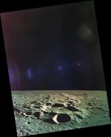
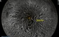
Hypatia A
Here is a LRO QuickMap link to match the Beresheet photo: http://bit.ly/2P984hh And attached is the correctly orientated Beresheet photo.
Attached thumbnail(s)
|
|
 |
 
|
|
|
Apr 14 2019, 04:12 AM
Post
#47
|
||
|
Junior Member Group: Members Posts: 31 Joined: 24-February 17 From: California Member No.: 8127 |
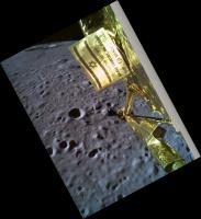
Beresheet's last photo...
My correctly orientated and enhanced version of Beresheet's last published selfie photo is attached. The large crater seen in the distance (top and to the left of the flag) is Burg. Here is a LRO QuickMap 3D link for the photo: http://bit.ly/2P5MQkj
Attached thumbnail(s)
|
|
|
|
|
|
|
Apr 14 2019, 04:31 AM
Post
#48
|
|||
|
Junior Member Group: Members Posts: 31 Joined: 24-February 17 From: California Member No.: 8127 |
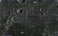
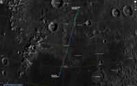
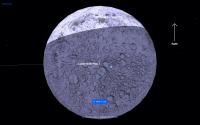
[attachment=44600:Bereshee...QuickMap.jpg]LRO QuickMap 2D and 3D screen captures, and QuickMap links for the screen captures...
This is NOT the correct flight path. I assumed that the selfie photo shown live was taken either just before or during descent: http://bit.ly/2Pbqspx This is NOT the correct flight path. I assumed that the selfie photo shown live was taken either just before or during descent: http://bit.ly/2P7DIvw
Attached thumbnail(s)
|
||
|
|
|
||
|
Apr 14 2019, 04:33 AM
Post
#49
|
||
|
Junior Member Group: Members Posts: 31 Joined: 24-February 17 From: California Member No.: 8127 |
This is not the correct flight path for the descent.
Attached thumbnail(s)
|
|
|
|
|
|
|
Apr 15 2019, 03:44 AM
Post
#50
|
|
|
Solar System Cartographer Group: Members Posts: 10145 Joined: 5-April 05 From: Canada Member No.: 227 |
"https://www.reddit.com/r/space/comments/bd34il/hi_my_name_is_ben_nathaniel_i_work_on_the_team_of/"
Reddit has this 'ask me anything' with a spaceIL team member. Among other things it confirms that the Hypatia image was taken 4 hours before the landing attempt (2 orbits earlier). I suspect that the Lacus Mortis image was taken on that orbit or the next. I don't think it can be from the descent, so I don't think a path can be mapped from the image location to the landing site. The time of image release is not indicative of when it was taken. The Reddit does say that there is another image not yet released, possibly from the actual descent. It also appears that there is some magnetometer data taken and probably on the ground. Phil -------------------- ... because the Solar System ain't gonna map itself.
Also to be found posting similar content on https://mastodon.social/@PhilStooke NOTE: everything created by me which I post on UMSF is considered to be in the public domain (NOT CC, public domain) |
|
|
|
|
Apr 15 2019, 06:50 AM
Post
#51
|
|
 Member Group: Members Posts: 122 Joined: 3-September 12 From: Almeria, SE Spain Member No.: 6632 |
Just two questions:
Was the (final) orbit perfectly polar, meaning inclination 90°? Or somewhat less? And: Was the spacecraft flying south->north or north->south when at the near side? I haven't read anything about this until now... Thorsten |
|
|
|
|
Apr 15 2019, 04:34 PM
Post
#52
|
|
|
Solar System Cartographer Group: Members Posts: 10145 Joined: 5-April 05 From: Canada Member No.: 227 |
See the LRO presentation at LEAG last year linked near the bottom of this page:
https://www.hou.usra.edu/meetings/leag2018/..._Recordings.pdf (you need Adobe Connect to view it, as unfortunately LEAG only archived the video presentation rather than the PDF of the slides. I would prefer both) The discussion illustrates the geometry of LRO observations of the actual landing with one modelled date in April. Bottom line, no direct observation possible, but the Beresheet orbit is shown as nearly polar and north to south on approach. Phil -------------------- ... because the Solar System ain't gonna map itself.
Also to be found posting similar content on https://mastodon.social/@PhilStooke NOTE: everything created by me which I post on UMSF is considered to be in the public domain (NOT CC, public domain) |
|
|
|
|
Apr 15 2019, 06:19 PM
Post
#53
|
|||
|
Junior Member Group: Members Posts: 31 Joined: 24-February 17 From: California Member No.: 8127 |
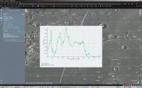
QUOTE (Phil Stooke @ Apr 14 2019, 08:44 PM)  "https://www.reddit.com/r/space/comments/bd34il/hi_my_name_is_ben_nathaniel_i_work_on_the_team_of/" Reddit has this 'ask me anything' with a spaceIL team member. Among other things it confirms that the Hypatia image was taken 4 hours before the landing attempt (2 orbits earlier). I suspect that the Lacus Mortis image was taken on that orbit or the next. I don't think it can be from the descent, so I don't think a path can be mapped from the image location to the landing site. The time of image release is not indicative of when it was taken. The Reddit does say that there is another image not yet released, possibly from the actual descent. It also appears that there is some magnetometer data taken and probably on the ground. Phil I agree. I found Beresheet's orbit telemetry which was updated up to the point where Beresheet flew over the lunar north polar area on April 11, before the descent sequence started. Here is the link (browser OpenGL support required to view the animation): https://live.spaceil.com/ When you play the simulation, the simulation at the end stops on April 11. It is also obvious that Beresheet was west of the lunar north pole on April 11 when it came into view from Earth. Given that Beresheet's polar orbit passes approximately 8 degrees west of the lunar north pole as seen from Earth, there is no way that the selfie shown during the live broadcast could have been later than the photo of Hypatia which was shown earlier during the live broadcast. Thus it seems that the selfie photo shown live must have been taken at least a few to several orbits before the Hypatia image was taken. I don't know why SpaceIL chose to show these two photos during the live broadcast since everyone assumed that these photos were live from the spacecraft, in particular, the selfie photo.
Attached thumbnail(s)
|
||
|
|
|
||
|
Apr 15 2019, 06:51 PM
Post
#54
|
||
|
Junior Member Group: Members Posts: 31 Joined: 24-February 17 From: California Member No.: 8127 |
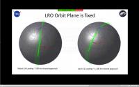
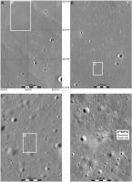
QUOTE (Phil Stooke @ Apr 15 2019, 09:34 AM) See the LRO presentation at LEAG last year linked near the bottom of this page: https://www.hou.usra.edu/meetings/leag2018/..._Recordings.pdf (you need Adobe Connect to view it, as unfortunately LEAG only archived the video presentation rather than the PDF of the slides. I would prefer both) The discussion illustrates the geometry of LRO observations of the actual landing with one modelled date in April. Bottom line, no direct observation possible, but the Beresheet orbit is shown as nearly polar and north to south on approach. Phil Hi Phil, Is the attached image the one you are talking about? I think that the orbits shown in green are the number of LRO orbits which, with off-axis slews, could image Beresheet's landing site if the LRO was in the correct position at the time for the proposed March 14 or April 12 landings. In the right image for April 12, the black line points towards Beresheet's primary landing site (plotted with both a red and black dot), and the red line points towards the alternate primary landing site plotted with a red dot. The other two backup landing sites in the southern hemisphere are also plotted with red dots. Thus the green orbits are not for Beresheet, but instead are for the LRO. At least this is the way that I am interpreting the images for the two dates.
Attached thumbnail(s)
|
|
|
|
|
|
|
Apr 15 2019, 10:56 PM
Post
#55
|
|
|
Solar System Cartographer Group: Members Posts: 10145 Joined: 5-April 05 From: Canada Member No.: 227 |
You are right! I had mis-remembered that presentation. I was thinking it showed the Beresheet trajectory as well. I am sure I saw it somewhere but now I can't recall where it was. Serves me right for not checking the video before posting. Sorry about that.
Phil -------------------- ... because the Solar System ain't gonna map itself.
Also to be found posting similar content on https://mastodon.social/@PhilStooke NOTE: everything created by me which I post on UMSF is considered to be in the public domain (NOT CC, public domain) |
|
|
|
|
Apr 17 2019, 02:48 PM
Post
#56
|
|
|
Member Group: Members Posts: 122 Joined: 3-September 12 From: Almeria, SE Spain Member No.: 6632 |
There is a new "final picture" from Beresheet!
 https://twitter.com/saetur/status/1118516159626784769   Thorsten |
|
|
|
|
Apr 17 2019, 07:18 PM
Post
#57
|
|
|
Senior Member Group: Members Posts: 2074 Joined: 13-February 10 From: Ontario Member No.: 5221 |
From their Twitter feed: "Here are the findings of the preliminary investigation of #Beresheets landing maneuver: It appears that during the landing process a command was entered that led to a chain reaction, which caused the main engine to switch off and prevented it from being reactivated."
Final report in a few weeks. |
|
|
|
|
May 15 2019, 02:35 PM
Post
#58
|
|
|
Senior Member Group: Members Posts: 1074 Joined: 21-September 07 From: Québec, Canada Member No.: 3908 |
|
|
|
|
|
May 15 2019, 05:52 PM
Post
#59
|
|||
|
Solar System Cartographer Group: Members Posts: 10145 Joined: 5-April 05 From: Canada Member No.: 227 |
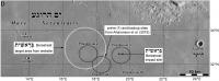
Yes indeed! Here's a finder map for the crash site.
And a broader view. I had assumed that 'Posidonius 1' was the primary site but maybe that's not correct. At any rate the impact occurred in their site 3. Note that a delay in landing would move the descent trajectory to the west, so the other sites could have functioned as targets for delayed landings.
Phil -------------------- ... because the Solar System ain't gonna map itself.
Also to be found posting similar content on https://mastodon.social/@PhilStooke NOTE: everything created by me which I post on UMSF is considered to be in the public domain (NOT CC, public domain) |
||
|
|
|
||
|
Jun 27 2019, 11:05 AM
Post
#60
|
|
|
Member Group: Members Posts: 122 Joined: 3-September 12 From: Almeria, SE Spain Member No.: 6632 |
Seems there will be no Beresheet-2 on the Moon.
 Been There, Crashed That: SpaceIL Wont Return to Moon with Beresheet 2 Thorsten |
|
|
|
|

|
Lo-Fi Version | Time is now: 16th April 2024 - 11:54 AM |
|
RULES AND GUIDELINES Please read the Forum Rules and Guidelines before posting. IMAGE COPYRIGHT |
OPINIONS AND MODERATION Opinions expressed on UnmannedSpaceflight.com are those of the individual posters and do not necessarily reflect the opinions of UnmannedSpaceflight.com or The Planetary Society. The all-volunteer UnmannedSpaceflight.com moderation team is wholly independent of The Planetary Society. The Planetary Society has no influence over decisions made by the UnmannedSpaceflight.com moderators. |
SUPPORT THE FORUM Unmannedspaceflight.com is funded by the Planetary Society. Please consider supporting our work and many other projects by donating to the Society or becoming a member. |
|