Opportunity Route Map |

  |
Opportunity Route Map |
 Jul 20 2006, 03:19 AM Jul 20 2006, 03:19 AM
Post
#1696
|
|
 Member  Group: Members Posts: 133 Joined: 3-June 06 From: the jungle of Nool Member No.: 799 |
QUOTE (jamescanvin @ Jul 19 2006, 07:17 PM)  OK, as soon as I put up that map, Exploratorium come back up.  Here is my best guess from sighting features for Sol 883. I put Oppy about 7 meters south and 2 meters east of your position. Measurments: 37 +/- 1 meters movement from measured parallax changes on a heading about 8 degrees to the right of the center of the crater just behind the 15 meter black dune crater ( BC) ; 49.5 +/- 1.2 to the front of the dune intersecting the crater on a line through BC; Consistancy checks: 41.5 +/- 0.8 on a line 28.0 degrees from BC through Oppy position intersecting the left edge of the dune abutting the 15 meter black crater. Also, visually, Oppy is now just in front of a fairly long stretch of outcrop -- the faint white line on the map. |
 |
 
|
|
Jul 20 2006, 04:26 AM
Post
#1697
|
||
 Senior Member Group: Moderator Posts: 2262 Joined: 9-February 04 From: Melbourne - Oz Member No.: 16 |
You mean somewhere near my point based on the tracking data alone?
Problem is, the angles are all wrong down there. Everything fits nicely up here.
Attached thumbnail(s)
-------------------- |
|
|
|
|
|
|
Jul 20 2006, 12:37 PM
Post
#1698
|
|
 Member Group: Members Posts: 656 Joined: 20-April 05 From: League City, Texas Member No.: 285 |
I too came up with a figure about six meters further south. There's room for error though, I'd feel more confident if there were some images in the direction we drove from; I'm having trouble identifying some rocks with confidence.
|
|
|
|
|
Jul 20 2006, 03:41 PM
Post
#1699
|
|
|
Member Group: Members Posts: 133 Joined: 3-June 06 From: the jungle of Nool Member No.: 799 |
QUOTE (algorimancer @ Jul 20 2006, 08:37 AM) I too came up with a figure about six meters further south. There's room for error though, I'd feel more confident if there were some images in the direction we drove from; I'm having trouble identifying some rocks with confidence. Hi Algorimancer. Just wanted to thank you for your wonderful parallax tool AlgorimancerPG. I used it exclusively for the parallax measurments in my sol 883 position estimation. I used the online tool MER Stereo Parallax Calculator for a long time, but discovered it was not very accurate for over 50 meters measurment. ( I routinely subtracted a 2 pixels correction. ) FYI, I remeasured several rocks after I refined the direction of motion and got a movement of 37.2 +/- 1 meters on a heading of 7.9 degrees right of center of the reference crater. Didn't make much difference in the original guess. The biggest error source is the center of the 10 meter reference crater. |
|
|
|
|
Jul 20 2006, 04:35 PM
Post
#1700
|
|
|
Member Group: Members Posts: 133 Joined: 3-June 06 From: the jungle of Nool Member No.: 799 |
Sol 884 looks like a 39 meter move just to the left of the 15 meter circular black dune. I thought it was a crater.
A Navcam parallax measurment to the closest rim of Beagle is 75 -15/+22 meters ( 75 meters as measured on the map ) |
|
|
|
|
Jul 20 2006, 05:15 PM
Post
#1701
|
|
 Senior Member Group: Moderator Posts: 3431 Joined: 11-August 04 From: USA Member No.: 98 |
QUOTE (hortonheardawho @ Jul 20 2006, 04:35 PM) Sol 884 looks like a 39 meter move just to the left of the 15 meter circular black dune. I thought it was a crater. We're just to the northeast of the dark feature - see here: here. |
|
|
|
|
Jul 20 2006, 05:48 PM
Post
#1702
|
|
|
Member Group: Members Posts: 656 Joined: 20-April 05 From: League City, Texas Member No.: 285 |
QUOTE (hortonheardawho @ Jul 20 2006, 10:41 AM) Hi Algorimancer. Just wanted to thank you for your wonderful parallax tool AlgorimancerPG. I used it exclusively for the parallax measurments in my sol 883 position estimation. ... FYI, I remeasured several rocks after I refined the direction of motion and got a movement of 37.2 +/- 1 meters on a heading of 7.9 degrees right of center of the reference crater. Didn't make much difference in the original guess. The biggest error source is the center of the 10 meter reference crater. Hi Horton, I'm always happy to see AlgorimancerPG in use, and I appreciate the positive feedback. You must be better at feature recognition than I am... I spent much of last evening trying to get a decent fix, with only moderate success; I was only able to identify a few distinct features with confidence. I think my best guess was something like 39 +/-1.5 meters, and I wasn't paying attention to direction, but I'm happy to see it agrees pretty well with your result. I suppose that the point is moot now since we've already moved on, and there seems little debate (now) as to our current (surprising) position up against West Hillock; in fact, 884 is probably going to be one of the best position fixes we've had. |
|
|
|
|
Jul 21 2006, 12:11 AM
Post
#1703
|
||
|
Senior Member Group: Moderator Posts: 2262 Joined: 9-February 04 From: Melbourne - Oz Member No.: 16 |
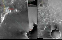
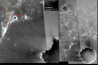
I still don't understand the reason for using the least accurate point on the map (the last position) as your primary reference when there are so many other real features around that can be seen both on the map and in the images. Furthermore I don't understand why you would rather use sub-degree angle changes between two cameras 20cm apart when you can use angles of 100's of degrees between features seen on the ground. Back in the badlands when there was nothing around that was exactly what we were doing, and when we get out onto Victoria's apron it may be the right thing to do again. But here, in possibly the most feature rich area in rover history, it makes no sense.
If the 883 point was 7m further south the features just do not fit, hence that position must be wrong wrt the MOC image, end of story. It doesn't matter how far we drove on that sol, that's not what the map shows, it just shows a sequence of rover positions wrt the MOC image. Anyway, moving on to 884 - I hope we all agree on this position. 
Fairly obvious - but I've double checked the bearings to the features around just to be sure. James -------------------- |
|
|
|
|
|
|
Jul 21 2006, 12:52 AM
Post
#1704
|
|
|
Member Group: Members Posts: 656 Joined: 20-April 05 From: League City, Texas Member No.: 285 |
QUOTE (jamescanvin @ Jul 20 2006, 07:11 PM) ... Anyway, moving on to 884 - I hope we all agree on this position. ... Fairly obvious - but I've double checked the bearings to the features around just to be sure. James I believe!  In my case, my bag of tricks for position finding depends upon reasonably good distance measurements common to both starting and ending positions, for at least one object, as well as angle measurements to that object from each position which can be be synchronized with the map view. Also, I'm new to the game, but figured that someone ought to step up to the plate while Tesheiner was on vacation. Fun Anyway, you've picked exactly the spot I would have this time. In my case, my bag of tricks for position finding depends upon reasonably good distance measurements common to both starting and ending positions, for at least one object, as well as angle measurements to that object from each position which can be be synchronized with the map view. Also, I'm new to the game, but figured that someone ought to step up to the plate while Tesheiner was on vacation. Fun Anyway, you've picked exactly the spot I would have this time.
|
|
|
|
|
Jul 21 2006, 12:55 AM
Post
#1705
|
|
|
Senior Member Group: Moderator Posts: 3431 Joined: 11-August 04 From: USA Member No.: 98 |
QUOTE (jamescanvin @ Jul 21 2006, 12:11 AM) Anyway, moving on to 884 - I hope we all agree on this position. One of the least-debatable positions in recent memory, IMHO. At least for this rover. |
|
|
|
|
Jul 21 2006, 09:43 PM
Post
#1706
|
||
|
Senior Member Group: Moderator Posts: 2262 Joined: 9-February 04 From: Melbourne - Oz Member No.: 16 |
Route map updated to sol 885 - Small (2.6m according to the tracking database) drive for weekend IDD work on "West Hillock"
Attached thumbnail(s)
-------------------- |
|
|
|
|
|
|
Jul 21 2006, 10:45 PM
Post
#1707
|
|
|
Member Group: Members Posts: 133 Joined: 3-June 06 From: the jungle of Nool Member No.: 799 |
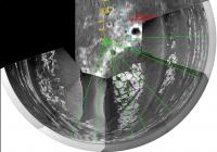
QUOTE (jamescanvin @ Jul 21 2006, 05:43 PM) Route map updated to sol 885 - Small (2.6m according to the tracking database) drive for weekend IDD work on "West Hillock" super 3D of Beagle from sol 884-885 movement:  I used this image and a parallax measurment on sol 884 to calculate a 2.8 meter movement towards Beagle. The technique uses the change in angular size of features plus a single distance measurment. The features were 14.5 meters and 6.59 degrees wide on sol 884 and 8.13 degrees wide on sol 885. |
|
|
|
|
Jul 21 2006, 11:20 PM
Post
#1708
|
|
|
Member Group: Members Posts: 133 Joined: 3-June 06 From: the jungle of Nool Member No.: 799 |
Ooops:
Got Before and after mixed up in the super 3D image. The 14.5 meter measurment is to the 4.06 degree before size and the 3.29 degree is the after size. The recalculation puts Oppy 3.4 meters further away from Beagle. I was really puzzled by the sol 885 navcams of West Hillock. They look closer -- so I measured and sure enough, Oppy was 3.1 meters closer! So I went back and looked at the super 3D... Sorry about that. |
|
|
|
|
Jul 27 2006, 12:04 PM
Post
#1709
|
|
 Member Group: Members Posts: 648 Joined: 9-May 05 From: Subotica Member No.: 384 |
After 6 days we are continuing drive toward Beagle Crater...today is drive sol.
QUOTE Sol Seq.Ver ETH ESF EDN EFF ERP Tot Description
--- -------- --- --- --- --- --- ---- ----------- 891 p1151.04 2 0 0 2 0 4 front_hazcam_idd_unstow_doc 891 p1154.01 2 0 0 2 0 4 front_hazcam_idd_unstow_doc 891 p1205.08 2 0 0 2 0 4 front_haz_penultimate_0.5_bpp_pri17 891 p1214.05 2 0 0 2 0 4 front_haz_ultimate_4bpp_pri15 891 p1275.01 2 0 0 2 0 4 front_hazcam_0.5bpp_pri_41 891 p1305.07 2 0 0 2 0 4 rear_haz_penultimate_0.5bpp_pri17 891 p1311.07 2 0 0 2 0 4 rear_haz_ultimate_1_bpp_crit15 891 p1375.01 2 0 0 2 0 4 rear_hazcam_0.5bpp_pri_41 891 p1375.01 2 0 0 2 0 4 rear_hazcam_0.5bpp_pri_41 891 p1585.00 4 0 4 0 0 8 navcam_cloud_4x1_dwnsmp_RVRAz_calstart 891 p1824.01 10 0 0 10 0 20 navcam_5x1_az_234_1_bpp_pri29 891 p1825.01 10 0 0 10 0 20 navcam_5x1_az_54_3_bpp_pri_29 891 p2111.05 13 13 0 0 2 28 pancam_cal_targ_L234567Rall 891 p2352.08 12 0 0 12 2 26 pancam_drive_direction_L2R2 891 p2556.16 13 0 0 13 2 28 pancam_scuff_jesse_chisholm_L234567Rall 891 p2600.09 2 2 0 0 2 6 pancam_tau 891 Total 82 15 4 63 8 172 -------------------- The scientist does not study nature because it is useful; he studies it because he delights in it, and he delights in it because it is beautiful.
Jules H. Poincare My "Astrophotos" gallery on flickr... |
|
|
|
|
Jul 27 2006, 12:15 PM
Post
#1710
|
|
|
Member Group: Members Posts: 235 Joined: 2-August 05 Member No.: 451 |
I'm sure it has been explained somewhere, but after a quick look I didn't find it. Can someone please tell me what Sol Seq.Ver ETH ESF EDN EFF ERP Tot all mean? (OK, the first one is pretty obvious, and the 8th one is clearly the total of all the 3rd through 7th ones), but this seems to only be camera requests, and I don't understand how you make out that this makes it a drive day. Does it contain instructions on where to drive to? or how far to turn the wheels? If not perhaps there is another set of commands that we could see. I'd be interested in knowing how we tell these rovers to move.
|
|
|
|
|

|
Lo-Fi Version | Time is now: 1st May 2024 - 02:33 AM |
|
RULES AND GUIDELINES Please read the Forum Rules and Guidelines before posting. IMAGE COPYRIGHT |
OPINIONS AND MODERATION Opinions expressed on UnmannedSpaceflight.com are those of the individual posters and do not necessarily reflect the opinions of UnmannedSpaceflight.com or The Planetary Society. The all-volunteer UnmannedSpaceflight.com moderation team is wholly independent of The Planetary Society. The Planetary Society has no influence over decisions made by the UnmannedSpaceflight.com moderators. |
SUPPORT THE FORUM Unmannedspaceflight.com is funded by the Planetary Society. Please consider supporting our work and many other projects by donating to the Society or becoming a member. |
|