Juno, perijove 10, December 16, 2017 |

Juno, perijove 10, December 16, 2017 |
 Dec 18 2017, 12:15 PM Dec 18 2017, 12:15 PM
Post
#1
|
|
|
Senior Member  Group: Members Posts: 2346 Joined: 7-December 12 Member No.: 6780 |
Data of Juno's Perijove-10 are going to be downlinked.
Here is a tiny 6000-fold time-lapsed simulation from 2017-12-16T16:30:00.000 to 2017-12-16T20:00:00.000:  It shows, that during approach, Jupiter's night side has come into JunoCam's field of view, first. Then there have been some interesting new perspectives, before Jupiter's south polar region has been in JunoCam's view during departure. The simulation is based on preliminary, and on some reconstructed SPICE data. Timing of actual image data differ from the stills of the above tiny simulation. |
 |
 
|
 |
|
Dec 30 2017, 07:13 PM
Post
#2
|
||||||||
 IMG to PNG GOD Group: Moderator Posts: 2250 Joined: 19-February 04 From: Near fire and ice Member No.: 38 |
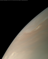
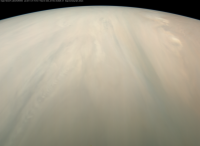
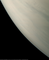
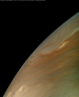
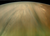
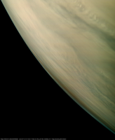
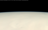
Here are my versions of image PJ10_028. I recently made minor improvements to my processing. The biggest difference is that now I no longer 'lose' the fuzzy and bluish horizon at the limb in the hi-res images as as result of the processing (the limb isn't sharply defined in these images as in my earlier images). First three approximately true color/contrast versions:
Notice the bluish horizon at the limb, especially in the central image. This is Jupiter's blue sky. And versions with enhanced colors, contrast and sharpness:
Juno was only 4420 km above Jupiter's clouds. This is especially obvious in the central image which has a field of view of 70 degrees. The image below shows Jupiter's blue sky at the limb; this is an approximately true color/contrast image. This image has a field of view of 20 degrees. This corresponds to an enlargement by a factor of ~3 compared to the original framelets.
And finally a subset of the relevant metadata: IMAGE_TIME = 2017-12-16T17:59:33.468 MISSION_PHASE_NAME = PERIJOVE 10 PRODUCT_ID = JNCE_2017350_10C00028_V01 SPACECRAFT_ALTITUDE = 4420.2 SPACECRAFT_NAME = JUNO SUB_SPACECRAFT_LATITUDE = 5.7721 SUB_SPACECRAFT_LONGITUDE = 297.5258 TITLE = North Equatorial Belt, southern edge Resolution at nadir: ~3.0 km/pixel |
|||||||
|
|
|
|||||||
 Gerald Juno, perijove 10 Dec 18 2017, 12:15 PM
 Adam Hurcewicz I can't wait for new pictures ! Dec 18 2017, 01:40 PM Bjorn Jonsson This is also interesting (from https://www.mission... Dec 18 2017, 09:52 PM Gerald Near closest approach, the contrast turned out to ... Dec 18 2017, 10:17 PM
 Bjorn Jonsson QUOTE (Gerald @ Dec 18 2017, 10:17 PM) Th... Dec 18 2017, 10:33 PM Gerald Provided, Juno gets an extension until 2021, and t... Dec 18 2017, 10:46 PM Kevin Gill The Perijove 10 images are now being added to the ... Dec 19 2017, 10:03 PM Kevin Gill A quick processing of four of the Perijove 10 imag... Dec 19 2017, 11:07 PM Gerald With some delay, here my set of drafts of the firs... Dec 20 2017, 03:16 AM Sean This already looks like an exceptional set Gerald.... Dec 20 2017, 11:20 AM Gerald A tiny animation of the RGB images available thus ... Dec 20 2017, 01:13 PM Gerald PJ-10, #021:
Dec 20 2017, 01:16 PM Gerald #022:
Dec 20 2017, 01:21 PM Gerald #023:
Dec 20 2017, 01:23 PM Gerald #024:
Dec 20 2017, 01:29 PM Gerald Rendition of the very close-ups takes a little lon... Dec 20 2017, 01:42 PM Gerald #026:
Dec 20 2017, 02:02 PM Gerald #027, and #028:
Dec 20 2017, 02:32 PM Gerald ... and #031:
All images of this series are repr... Dec 20 2017, 02:54 PM Gerald PNG versions are uploaded to junocam.pictures. Mos... Dec 20 2017, 05:31 PM Kevin Gill Here's the remainder of my 1st pass of the Per... Dec 20 2017, 08:13 PM Sean Some details from Gerald's pass on Perijove 10... Dec 20 2017, 09:01 PM Sean *update...re-ordered*
PJ10_021 [G.Eichstadt]
... Dec 21 2017, 06:17 PM Sean Another from Gerald's awesome source image...
... Dec 22 2017, 04:39 PM Kevin Gill Updates to PJ10 images with improved color. Alignm... Dec 22 2017, 07:47 PM Floyd Kevin--Like Sean you can start with Gerald's e... Dec 22 2017, 10:44 PM Gerald Drafts of Perijove-10, part 2. Those aren't ye... Dec 23 2017, 01:50 AM Kevin Gill Floyd, I'm stubbornly working on my own pipeli... Dec 23 2017, 02:20 AM Sean I really value Kevin's contributions as they p... Dec 23 2017, 03:43 AM Gerald I'll provide the second part of PJ-10 in the o... Dec 23 2017, 04:02 AM Gerald #46, and #38:
Dec 23 2017, 04:06 AM Gerald #47, #31, #39:
Dec 23 2017, 04:11 AM Gerald #40, #48, #49:
Dec 23 2017, 04:22 AM Gerald #41, #42, #32:
Dec 23 2017, 04:26 AM Gerald #33:
Dec 23 2017, 04:35 AM Gerald #34, #36:
Dec 23 2017, 04:50 AM Gerald ... and #37:
Dec 23 2017, 04:51 AM Gerald The PNG-Version of PJ-10 reprojections, part 2, is... Dec 23 2017, 07:04 AM Kevin Gill Overview of Perijove 10 using images I've proc... Dec 23 2017, 07:41 PM Sean PJ10_037 [G.Eichstadt]
PJ10_038
Process...
Ups... Dec 25 2017, 05:13 AM Gerald Website with PJ10 flyby movie stills partially upd... Dec 25 2017, 10:46 AM avisolo THANKS SO MUCH GERALD FOR YOUR STELLAR WORK IN ADV... Dec 25 2017, 12:33 PM Sean Click thru for a quick retime on Gerald's PJ10... Dec 26 2017, 05:05 AM Sean PJ10_039 [G.Eichstadt] Dec 28 2017, 12:38 PM Gerald Thanks, AviSolo!
The vast majority of the meri... Jan 1 2018, 08:16 PM Bjorn Jonsson QUOTE (Gerald @ Jan 1 2018, 08:16 PM) I... Jan 3 2018, 10:50 PM Bjorn Jonsson And here are my versions of the PJ10_024 image (No... Jan 3 2018, 10:58 PM tolis QUOTE (Bjorn Jonsson @ Jan 3 2018, 11:58 ... Jan 4 2018, 06:19 PM Gerald In his recent, first PJ-10 report, John Rogers (BA... Jan 4 2018, 10:15 PM Sean Here is my take on Gerald's PJ10_034... Jan 12 2018, 09:41 PM Gerald Jupiter in Perijove-10's Io shine, noisy proof... Jan 31 2018, 12:07 PM Gsnorgathon Good job, Gerald! Are those Jupiter's ring... Feb 3 2018, 12:36 AM mcaplinger QUOTE (Gsnorgathon @ Feb 2 2018, 04:36 PM... Feb 3 2018, 01:54 AM elakdawalla That is something I never anticipated could be don... Feb 1 2018, 01:19 AM Explorer1 I can't remember. the rings have already been ... Feb 3 2018, 02:33 AM mcaplinger QUOTE (Explorer1 @ Feb 2 2018, 06:33 PM) ... Feb 3 2018, 03:29 AM Brian Swift QUOTE (Explorer1 @ Feb 2 2018, 06:33 PM) ... Feb 3 2018, 06:01 AM Bjorn Jonsson Here is a GIF time-lapse from the PJ10_33 and PJ10... Feb 7 2018, 11:06 PM Gerald Link to PJ10 FFR animated gif. Mar 8 2018, 12:10 AM Gerald This PJ-10 YouTube movie combines two time-lapse r... Mar 8 2018, 10:38 AM Sean Some cloud detail from PJ10_26 [M.Brealey] Mar 21 2018, 01:18 AM Sean PJ10_32 [M.Brealey]
Filled a data gap image lowe... Mar 21 2018, 11:16 AM Phil Stooke Here are Sean's Juno images on display at LPSC... Mar 30 2018, 09:34 PM Sean PJ10_34_new pass Apr 13 2018, 04:48 PM Sean PJ10_23 details & portrait, new pass Apr 16 2018, 06:46 PM volcanopele
JIRAM data from PJ10 has been released to the PD... Jul 13 2018, 10:45 PM Floyd Hi Volcanopele--Very interesting. Could you label... Jul 14 2018, 12:01 PM volcanopele Those three are all from PJ10. I made another pos... Jul 14 2018, 03:36 PM Sean Revisited PJ10_23 after Gerald... Jan 19 2019, 07:22 PM Sean Updates using a new image process...
PJ10_23 deta... Mar 15 2019, 03:57 AM Sean PJ10_22 Mar 15 2019, 10:28 PM
Bjorn Jonsson QUOTE (Gerald @ Dec 18 2017, 10:17 PM) Th... Dec 18 2017, 10:33 PM Gerald Provided, Juno gets an extension until 2021, and t... Dec 18 2017, 10:46 PM Kevin Gill The Perijove 10 images are now being added to the ... Dec 19 2017, 10:03 PM Kevin Gill A quick processing of four of the Perijove 10 imag... Dec 19 2017, 11:07 PM Gerald With some delay, here my set of drafts of the firs... Dec 20 2017, 03:16 AM Sean This already looks like an exceptional set Gerald.... Dec 20 2017, 11:20 AM Gerald A tiny animation of the RGB images available thus ... Dec 20 2017, 01:13 PM Gerald PJ-10, #021:
Dec 20 2017, 01:16 PM Gerald #022:
Dec 20 2017, 01:21 PM Gerald #023:
Dec 20 2017, 01:23 PM Gerald #024:
Dec 20 2017, 01:29 PM Gerald Rendition of the very close-ups takes a little lon... Dec 20 2017, 01:42 PM Gerald #026:
Dec 20 2017, 02:02 PM Gerald #027, and #028:
Dec 20 2017, 02:32 PM Gerald ... and #031:
All images of this series are repr... Dec 20 2017, 02:54 PM Gerald PNG versions are uploaded to junocam.pictures. Mos... Dec 20 2017, 05:31 PM Kevin Gill Here's the remainder of my 1st pass of the Per... Dec 20 2017, 08:13 PM Sean Some details from Gerald's pass on Perijove 10... Dec 20 2017, 09:01 PM Sean *update...re-ordered*
PJ10_021 [G.Eichstadt]
... Dec 21 2017, 06:17 PM Sean Another from Gerald's awesome source image...
... Dec 22 2017, 04:39 PM Kevin Gill Updates to PJ10 images with improved color. Alignm... Dec 22 2017, 07:47 PM Floyd Kevin--Like Sean you can start with Gerald's e... Dec 22 2017, 10:44 PM Gerald Drafts of Perijove-10, part 2. Those aren't ye... Dec 23 2017, 01:50 AM Kevin Gill Floyd, I'm stubbornly working on my own pipeli... Dec 23 2017, 02:20 AM Sean I really value Kevin's contributions as they p... Dec 23 2017, 03:43 AM Gerald I'll provide the second part of PJ-10 in the o... Dec 23 2017, 04:02 AM Gerald #46, and #38:
Dec 23 2017, 04:06 AM Gerald #47, #31, #39:
Dec 23 2017, 04:11 AM Gerald #40, #48, #49:
Dec 23 2017, 04:22 AM Gerald #41, #42, #32:
Dec 23 2017, 04:26 AM Gerald #33:
Dec 23 2017, 04:35 AM Gerald #34, #36:
Dec 23 2017, 04:50 AM Gerald ... and #37:
Dec 23 2017, 04:51 AM Gerald The PNG-Version of PJ-10 reprojections, part 2, is... Dec 23 2017, 07:04 AM Kevin Gill Overview of Perijove 10 using images I've proc... Dec 23 2017, 07:41 PM Sean PJ10_037 [G.Eichstadt]
PJ10_038
Process...
Ups... Dec 25 2017, 05:13 AM Gerald Website with PJ10 flyby movie stills partially upd... Dec 25 2017, 10:46 AM avisolo THANKS SO MUCH GERALD FOR YOUR STELLAR WORK IN ADV... Dec 25 2017, 12:33 PM Sean Click thru for a quick retime on Gerald's PJ10... Dec 26 2017, 05:05 AM Sean PJ10_039 [G.Eichstadt] Dec 28 2017, 12:38 PM Gerald Thanks, AviSolo!
The vast majority of the meri... Jan 1 2018, 08:16 PM Bjorn Jonsson QUOTE (Gerald @ Jan 1 2018, 08:16 PM) I... Jan 3 2018, 10:50 PM Bjorn Jonsson And here are my versions of the PJ10_024 image (No... Jan 3 2018, 10:58 PM tolis QUOTE (Bjorn Jonsson @ Jan 3 2018, 11:58 ... Jan 4 2018, 06:19 PM Gerald In his recent, first PJ-10 report, John Rogers (BA... Jan 4 2018, 10:15 PM Sean Here is my take on Gerald's PJ10_034... Jan 12 2018, 09:41 PM Gerald Jupiter in Perijove-10's Io shine, noisy proof... Jan 31 2018, 12:07 PM Gsnorgathon Good job, Gerald! Are those Jupiter's ring... Feb 3 2018, 12:36 AM mcaplinger QUOTE (Gsnorgathon @ Feb 2 2018, 04:36 PM... Feb 3 2018, 01:54 AM elakdawalla That is something I never anticipated could be don... Feb 1 2018, 01:19 AM Explorer1 I can't remember. the rings have already been ... Feb 3 2018, 02:33 AM mcaplinger QUOTE (Explorer1 @ Feb 2 2018, 06:33 PM) ... Feb 3 2018, 03:29 AM Brian Swift QUOTE (Explorer1 @ Feb 2 2018, 06:33 PM) ... Feb 3 2018, 06:01 AM Bjorn Jonsson Here is a GIF time-lapse from the PJ10_33 and PJ10... Feb 7 2018, 11:06 PM Gerald Link to PJ10 FFR animated gif. Mar 8 2018, 12:10 AM Gerald This PJ-10 YouTube movie combines two time-lapse r... Mar 8 2018, 10:38 AM Sean Some cloud detail from PJ10_26 [M.Brealey] Mar 21 2018, 01:18 AM Sean PJ10_32 [M.Brealey]
Filled a data gap image lowe... Mar 21 2018, 11:16 AM Phil Stooke Here are Sean's Juno images on display at LPSC... Mar 30 2018, 09:34 PM Sean PJ10_34_new pass Apr 13 2018, 04:48 PM Sean PJ10_23 details & portrait, new pass Apr 16 2018, 06:46 PM volcanopele
JIRAM data from PJ10 has been released to the PD... Jul 13 2018, 10:45 PM Floyd Hi Volcanopele--Very interesting. Could you label... Jul 14 2018, 12:01 PM volcanopele Those three are all from PJ10. I made another pos... Jul 14 2018, 03:36 PM Sean Revisited PJ10_23 after Gerald... Jan 19 2019, 07:22 PM Sean Updates using a new image process...
PJ10_23 deta... Mar 15 2019, 03:57 AM Sean PJ10_22 Mar 15 2019, 10:28 PM |

|
Lo-Fi Version | Time is now: 25th April 2024 - 04:16 PM |
|
RULES AND GUIDELINES Please read the Forum Rules and Guidelines before posting. IMAGE COPYRIGHT |
OPINIONS AND MODERATION Opinions expressed on UnmannedSpaceflight.com are those of the individual posters and do not necessarily reflect the opinions of UnmannedSpaceflight.com or The Planetary Society. The all-volunteer UnmannedSpaceflight.com moderation team is wholly independent of The Planetary Society. The Planetary Society has no influence over decisions made by the UnmannedSpaceflight.com moderators. |
SUPPORT THE FORUM Unmannedspaceflight.com is funded by the Planetary Society. Please consider supporting our work and many other projects by donating to the Society or becoming a member. |
|