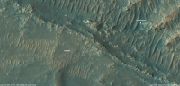
South from the landing site, sols 72-237, Starting the science traverse |

  |
South from the landing site, sols 72-237, Starting the science traverse |
 Sep 29 2021, 04:53 PM Sep 29 2021, 04:53 PM
Post
#676
|
||
 Member  Group: Members Posts: 665 Joined: 9-May 21 From: Germany Member No.: 9017 |
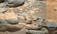
The closest Mastcam Z image from sol 213 with 110 mm focal length missed the SuperCam RMI target from sol 214 by only a few centimeters
|
|
 |
 
|
|
|
Sep 30 2021, 03:41 AM
Post
#677
|
|
|
Senior Member Group: Members Posts: 1043 Joined: 17-February 09 Member No.: 4605 |
QUOTE (tdemko @ Sep 28 2021, 04:35 AM)  .....I'm sticking with my subaqueous sediment gravity flow/turbidite interpretation until I see something inconsistent. Just for clarity Tim. You previously mentioned the delta front for gravity flow/turbide deposition. While these rocks tend to have moved around somewhat, given the apparent lack of dip, do you mean the delta toe? Apologies if I'm missing something obvious. |
|
|
|
|
Sep 30 2021, 01:12 PM
Post
#678
|
|||
|
Member Group: Members Posts: 665 Joined: 9-May 21 From: Germany Member No.: 9017 |
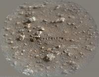
Another SuperCam RMI from sol 214 with Mastcam-Z context from sol 213.
A two-step stereoscopic grain-size measurement gives a diameter of about 0.25 to 0.4 mm for the small visible grains (medium sand according to the Wentworth scale) covering the plane between some coarse grains and irregularly shaped rock fragments in the SuperCam image.
|
||
|
|
|
||
|
Sep 30 2021, 03:39 PM
Post
#679
|
||
|
Senior Member Group: Members Posts: 2998 Joined: 30-October 04 Member No.: 105 |
QUOTE (tau @ Sep 30 2021, 08:12 AM) Another SuperCam RMI from sol 214 with Mastcam-Z context from sol 213.
What is that disturbance in the sand behind the scale bars? The Rover wheels haven't been there, nor has the instrument Arm. And Laser Zaaps! don't fluff up the soil like that. Martian soil is generally interesting. We need kilograms of samples! --Bill -------------------- |
|
|
|
|
|
|
Sep 30 2021, 04:21 PM
Post
#680
|
||
|
Member Group: Members Posts: 665 Joined: 9-May 21 From: Germany Member No.: 9017 |
It was the laser.
|
|
|
|
|
|
|
Sep 30 2021, 06:12 PM
Post
#681
|
|
|
Senior Member Group: Members Posts: 2998 Joined: 30-October 04 Member No.: 105 |
Interesting bit of information. I wasn't aware that the soil reacted like that to the Laser.
I recall that the drill cuttings at an earlier stop fused into glassy lumps. But that this soil reacts so strongly to the Laser's heat implies hydrated minerals which could suggest particular weathering processes. --Bill -------------------- |
|
|
|
|
Sep 30 2021, 07:52 PM
Post
#682
|
|
|
Member Group: Members Posts: 665 Joined: 9-May 21 From: Germany Member No.: 9017 |
Hydrated minerals are not required for this effect.
The SuperCam uses its laser, among other things, for laser-induced breakdown spectroscopy. A powerful laser beam vaporizes a tiny target volume and converts it into plasma. This acts like a small explosion sufficient to blow away surrounding particles. |
|
|
|
|
Sep 30 2021, 09:22 PM
Post
#683
|
|
 Member Group: Members Posts: 153 Joined: 8-February 04 From: Phoenix, AZ USA Member No.: 9 |
QUOTE (serpens @ Sep 29 2021, 10:41 PM) Just for clarity Tim. You previously mentioned the delta front for gravity flow/turbide deposition. While these rocks tend to have moved around somewhat, given the apparent lack of dip, do you mean the delta toe? Apologies if I'm missing something obvious. No, I think you are more correct here. We've seen some of the later foreset successions in the cliff faces. If these beds are what I think they are, the subaqueous sediment gravity flows would have originated either as collapse of the mouthbars or lip of the delta, and then flowed down the foreset/delta front, to the toeset, and potentially out onto the lake floor. If the river inflow was dense enough, hyperpyncnal underflows (which are also sediment gravity flows) could also have generated similar deposits. The thin-bedded nature of the outcrops in question look to me like either toesets or parts of fans that would have been deposited outboard of the foreset/toeset strata. -------------------- Tim Demko
BioLink site |
|
|
|
|
Oct 1 2021, 05:06 AM
Post
#684
|
|
|
Senior Member Group: Members Posts: 1043 Joined: 17-February 09 Member No.: 4605 |
QUOTE (tau @ Sep 30 2021, 02:12 PM) A two-step stereoscopic grain-size measurement gives a diameter of about 0.25 to 0.4 mm for the small visible grains (medium sand according to the Wentworth scale) covering the plane between some coarse grains and irregularly shaped rock fragments in the SuperCam image. As far as I know we have not seen any large clasts in surrounding rocks and the rock fragments you note look like conglomerates consisting of small particles. The effect of the laser shots may indicate that there is a desert pavement effect here with the underlying particles extremely fine. Potentially fallout of suspended load in Tim Denko's deposition model. I wonder whether the small particle size indicates a lower energy flow than was necessary for the formation of the main deltas. Potentially transport and deposition in a drier period or even prior to the breach of the crater wall by the input rivers as water entered through fractures, undermining the wall. Certainly there is no possibility that the crater wall was overtopped. |
|
|
|
|
Oct 1 2021, 12:33 PM
Post
#685
|
|
 Senior Member Group: Members Posts: 1619 Joined: 12-February 06 From: Bergerac - FR Member No.: 678 |
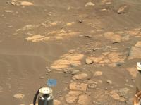
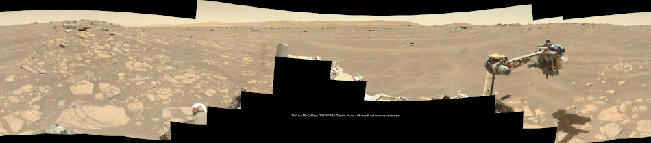
Sol 213 MastcamZ panoramic at 34mm. This is our parking spot during the solar conjunction. Including a dust devil
-------------------- |
|
|
|
|
Oct 3 2021, 05:04 PM
Post
#686
|
||
|
Member Group: Members Posts: 665 Joined: 9-May 21 From: Germany Member No.: 9017 |
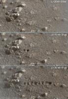
Sol 213 Mastcam-Z with greatly enhanced colors and contrasts.
This would make a nice backdrop for the sand ships in Ray Bradbury's "Martian Chronicles".
|
|
|
|
|
|
|
Oct 4 2021, 06:07 PM
Post
#687
|
|
|
Solar System Cartographer Group: Members Posts: 10153 Joined: 5-April 05 From: Canada Member No.: 227 |
Here is a nice mission journal from the Supercam team in France. There are a few target names in it which I am adding to maps.
Phil https://supercam.cnes.fr/fr/journal-de-bord...ot-perseverance -------------------- ... because the Solar System ain't gonna map itself.
Also to be found posting similar content on https://mastodon.social/@PhilStooke Maps for download (free PD: https://upload.wikimedia.org/wikipedia/comm...Cartography.pdf NOTE: everything created by me which I post on UMSF is considered to be in the public domain (NOT CC, public domain) |
|
|
|
|
Oct 4 2021, 06:09 PM
Post
#688
|
|
|
Solar System Cartographer Group: Members Posts: 10153 Joined: 5-April 05 From: Canada Member No.: 227 |
And here:
https://fiso.spiritastro.net/telecon/Bapst-...wMaser_9-29-21/ is a presentation about Ingenuity with a PDF of slides and an MP3 of the talk. There is a map with feature names, but it's barely legible. I can pick out a few to use. Can anyone figure out the name of the crater just south of the landing site? Phil -------------------- ... because the Solar System ain't gonna map itself.
Also to be found posting similar content on https://mastodon.social/@PhilStooke Maps for download (free PD: https://upload.wikimedia.org/wikipedia/comm...Cartography.pdf NOTE: everything created by me which I post on UMSF is considered to be in the public domain (NOT CC, public domain) |
|
|
|
|
Oct 4 2021, 11:49 PM
Post
#689
|
|
|
Solar System Cartographer Group: Members Posts: 10153 Joined: 5-April 05 From: Canada Member No.: 227 |
With help from Mike I found this page:
https://rps.nasa.gov/resources/115/nasas-pe...dziilii-crater/ so there's another name. Phil -------------------- ... because the Solar System ain't gonna map itself.
Also to be found posting similar content on https://mastodon.social/@PhilStooke Maps for download (free PD: https://upload.wikimedia.org/wikipedia/comm...Cartography.pdf NOTE: everything created by me which I post on UMSF is considered to be in the public domain (NOT CC, public domain) |
|
|
|
|
Oct 8 2021, 06:07 AM
Post
#690
|
||
 Senior Member Group: Members Posts: 2428 Joined: 30-January 13 From: Penang, Malaysia. Member No.: 6853 |
Unless there is a large dark rock next to Ingenuity then its blades / shadow are also included in this crop from this HiRISE image https://www.uahirise.org/ESP_071077_1985
|
|
|
|
|
|
|

|
Lo-Fi Version | Time is now: 30th April 2024 - 01:22 PM |
|
RULES AND GUIDELINES Please read the Forum Rules and Guidelines before posting. IMAGE COPYRIGHT |
OPINIONS AND MODERATION Opinions expressed on UnmannedSpaceflight.com are those of the individual posters and do not necessarily reflect the opinions of UnmannedSpaceflight.com or The Planetary Society. The all-volunteer UnmannedSpaceflight.com moderation team is wholly independent of The Planetary Society. The Planetary Society has no influence over decisions made by the UnmannedSpaceflight.com moderators. |
SUPPORT THE FORUM Unmannedspaceflight.com is funded by the Planetary Society. Please consider supporting our work and many other projects by donating to the Society or becoming a member. |
|