Unmanned Spaceflight.com > All posts by a member
| Posted on: Sep 13 2007, 10:36 PM | |
|
Junior Member  Group: Members Posts: 52 Joined: 24-May 06 Member No.: 784 |
QUOTE (Indian3000 @ Sep 13 2007, 09:38 PM)  sol 1293 Love the fractures that seem to run straight down into the crater. That one right in the center of your composite, especially. Post crater formation, yes? |
| Forum: Opportunity · Post Preview: #99389 · Replies: 608 · Views: 336498 |
| Posted on: Aug 22 2007, 06:47 PM | |
|
Junior Member Group: Members Posts: 52 Joined: 24-May 06 Member No.: 784 |
QUOTE (fredk @ Aug 22 2007, 04:00 PM) I am surprized at how much dustier the left navcam is than the right. I mean, the left and right navcams are pointing in the same direction only centimetres apart. Does that mean the dust is blowing in clumps? Fortunately the right navcams are always sharper than the left! It'd be a shame to have the next rover design not have a small ultrasonic shaker for the front glass of the cams, but I understand harsh environmental conditions might preclude that addition. Re: Dust in clumps -- I'm thinking more of differential electrostatic charge, perhaps based on position relative to wind direction. Just a wild guess, though. |
| Forum: Opportunity · Post Preview: #97251 · Replies: 543 · Views: 373599 |
| Posted on: Jul 21 2007, 09:52 PM | |
|
Junior Member Group: Members Posts: 52 Joined: 24-May 06 Member No.: 784 |
Idle question -- please consider me off my rocker, but I'm curious if anyone's anticipating the storm to warm some areas enough for a "water release event" in various crater walls. |
| Forum: Opportunity · Post Preview: #95530 · Replies: 543 · Views: 373599 |
| Posted on: May 13 2007, 03:22 AM | |
|
Junior Member Group: Members Posts: 52 Joined: 24-May 06 Member No.: 784 |
QUOTE (fredk @ May 12 2007, 06:09 PM) Some very distinct colours there. There's an interesting story to work out here no doubt. Thin layering, less friable/more erosion resistant... Possible non-aeolian deposition? Get me a trampoline, I'm jumping to conclusions! |
| Forum: Opportunity · Post Preview: #90069 · Replies: 178 · Views: 122496 |
| Posted on: May 9 2007, 04:13 PM | |
|
Junior Member Group: Members Posts: 52 Joined: 24-May 06 Member No.: 784 |
QUOTE (fredk @ May 9 2007, 03:18 PM) Granada: You know for an area that's supposed to be pretty windy, that fine dust in the raised sections of that pic sure doesn't make it look like it's been excessively windy --lately, anyway. Not a lot of dust on the lee side of these rocks either. And relatively sharp edges there. The 3-D view shows that off nicely. Thanks. |
| Forum: Opportunity · Post Preview: #89836 · Replies: 178 · Views: 122496 |
| Posted on: Apr 26 2007, 04:58 AM | |
|
Junior Member Group: Members Posts: 52 Joined: 24-May 06 Member No.: 784 |
QUOTE (atomoid @ Apr 25 2007, 10:32 PM) dune layering on the plains consisting of fines blowing in from the whole planet in general to mix unevenly with the larger local grains i think... I used to think that as well, but I went back over the dune pictures, and it looked like the layering became more distinctive as Oppy approached the crater annulus. I starting thinking about what fines could come out of the crater and what that additional deposition might look like. I'm having second thoughts about how the dark layers in the area around the annulus were formed. I'll still lean toward "global dark fines floating down" but how much dust did come out of that crater? Any? I mean, if that much wind erosion went on, it couldn't all stay in the crater. Did many of the blueberries knock together enough to grind them into "blueberry dust" and then got blown off the annulus? I don't know. There's more to the wind profile than meets the eye. |
| Forum: Opportunity · Post Preview: #88995 · Replies: 432 · Views: 228115 |
| Posted on: Apr 25 2007, 05:05 PM | |
|
Junior Member Group: Members Posts: 52 Joined: 24-May 06 Member No.: 784 |
Are fines coming out of the crater responsible for the apparent layering (dark and light layers) in the dunes we saw on the way to Victoria? |
| Forum: Opportunity · Post Preview: #88954 · Replies: 432 · Views: 228115 |
| Posted on: Apr 17 2007, 04:19 AM | |
|
Junior Member Group: Members Posts: 52 Joined: 24-May 06 Member No.: 784 |
QUOTE (nprev @ Apr 17 2007, 03:06 AM) the blueberries are obviously much less wind-transportable than dust. I'm not sure what Martian wind velocity would be required to move significant numbers of those blueberries. I wonder if the wind was strong enough to roll a few of them off the northern apron of Victoria's annulus. |
| Forum: Opportunity · Post Preview: #88431 · Replies: 432 · Views: 228115 |
| Posted on: Apr 9 2007, 09:21 PM | |
|
Junior Member Group: Members Posts: 52 Joined: 24-May 06 Member No.: 784 |
QUOTE (Edward Schmitz @ Apr 9 2007, 08:15 PM) How about these... I take it the possibility that this dark material might be originally caused by groundwater coming out in a point source fashion has been addressed? Because from your image on the left, that's certainly what it appears like. There's not so much as an outcrop as there is an old flow of dark material from point sources in the wall. I'm sure this will be eventually settled with closer looks, but my first guess is water borne deposits into the NE section of the crater, and then that material blown up onto the annulus from the winds out of the South. My big question is _when_ this dark material appeared. Here's the final query of mine... more of a tease. We've already seen that in at least a couple of places under camera surveillance, groundwater has come to the surface. Say that these dark spots are some indication of old groundwater flows... wouldn't it be neat to think of this happening under our noses? |
| Forum: Opportunity · Post Preview: #87903 · Replies: 432 · Views: 228115 |
| Posted on: Mar 28 2007, 06:29 PM | |
|
Junior Member Group: Members Posts: 52 Joined: 24-May 06 Member No.: 784 |
Is there a current guess as to the initial slope? |
| Forum: Opportunity · Post Preview: #87014 · Replies: 217 · Views: 145237 |
| Posted on: Mar 18 2007, 03:48 PM | |
|
Junior Member Group: Members Posts: 52 Joined: 24-May 06 Member No.: 784 |
QUOTE (alan @ Mar 18 2007, 12:43 AM) Lots of little dark spots in the lump. Blueberries? Looks like. If so, that could mean only one thing: The lump is from "Below The Bathtub Ring" (BTBR)!! Sounds like a bad horror flick  |
| Forum: Opportunity · Post Preview: #86309 · Replies: 152 · Views: 113453 |
| Posted on: Mar 13 2007, 03:29 AM | |
|
Junior Member Group: Members Posts: 52 Joined: 24-May 06 Member No.: 784 |
I too believe this this bay is probably not the safest ingress (I'm a big fan of looking at the bays closer to the Soup Dragon) but since I also hold a lot of trust for Oppy's drivers and mgmt, I'll just sit here and prepare for the rollercoaster ride down. |
| Forum: Opportunity · Post Preview: #85838 · Replies: 217 · Views: 145237 |
| Posted on: Mar 9 2007, 08:57 PM | |
|
Junior Member Group: Members Posts: 52 Joined: 24-May 06 Member No.: 784 |
QUOTE (Tesheiner @ Mar 9 2007, 09:15 AM) Does anybody wants to risk a slope angle calculation based on the last pancams? A better contest than on which sol Oppy will put it's toe in the crater would be -- which bay will get the honor? |
| Forum: Opportunity · Post Preview: #85644 · Replies: 217 · Views: 145237 |
| Posted on: Feb 23 2007, 07:16 PM | ||
|
Junior Member Group: Members Posts: 52 Joined: 24-May 06 Member No.: 784 |
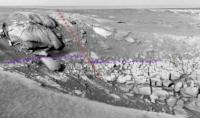
QUOTE (MarkL @ Feb 23 2007, 05:46 PM) [...]possibly associated with an east northeast-trending fault. I hesitate to call it that because all I see is the barest indication that there may be a fault which has created some elevation differential leading to the abrupt edge of the dunefield to the north. I laughed at first because I was thinking how odd it would be for a fault to show through that ejecta debris, but I'm a believer of sorts now. If that is a fault, it would show in the bay, and if it shows in the bay, what would it look like?
No smoking gun, but there does look to be a mismatch in that white layer where I've put the purple hint |
|
| Forum: Opportunity · Post Preview: #84392 · Replies: 152 · Views: 113453 |
| Posted on: Feb 23 2007, 02:53 PM | |
|
Junior Member Group: Members Posts: 52 Joined: 24-May 06 Member No.: 784 |
QUOTE (Tesheiner @ Feb 23 2007, 12:04 PM) Here is a three-frame navcam mosaic looking east and covering Bay C3, Cape of Good Hope (C3), Bay C5, and Cape D1. Cape of Good Hope(C3) and Cape D1 look like they were uplifted during the impact -- more so than some of the other capes we've seen to date. Very interesting stuff. [attachment=9446:attachment] (Feel free to move this to a new cape thread) |
| Forum: Opportunity · Post Preview: #84362 · Replies: 152 · Views: 113453 |
| Posted on: Feb 16 2007, 09:51 PM | |
|
Junior Member Group: Members Posts: 52 Joined: 24-May 06 Member No.: 784 |
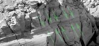
QUOTE (CosmicRocker @ Feb 11 2007, 06:57 AM) I think I previously offered a Mars Bar to the first person to identify a blueberry in rock below the ejecta [...] So allow me to suggest that one of the current challenges is to find the "bathtub ring." I thought we found it near the base of Verde -- Look to the rightmost base of Verde in this image enhancement by Hortonheardawho  The largest size of the image: http://www.flickr.com/photo_zoom.gne?id=256610074&size=o I'm pretty sure there's some depositional variations that we haven't seen quite as clearly in the other Capes. I count three separate divisions here, one at the base, one above that, and then the more massive aeolian section we're familiar with. Now, they indeed COULD be all the same unit, particularly the middle unit, but more on that in a minute. The lowest unit, just looks different. I think there's a stratigraphic equivilent on the other side of the crater, at the "F1" wall, or to the left of Soup Dragon. You can click over to that thread to see my original obsession with that. The closer we get to that F1, the more I think that's probably NOT exactly it, but it's just too hard to tell. The last candidate for this same rock type is near the base of the ramp of "G1", but it's just a scrap. Now, I'm not convinced you're going to find traces of hematite berries in these rocks, but I'm pretty sure that we're not dealing with just another sub-layer of the aeolian section above. Perhaps a transition to the berry bearing rocks below? Obviously we won't know enough for several months as Oppy rolls into Victoria and gets some better views, but the base of Cape Verde has the most unique rock types than any other Cape we've seen so far. We've seen at least some view of all the capes all the way around, with the exception of the last of these most northern capes and those images will be coming shortly. The original rock type of the basal unit seen at Verde might be aeolian but I think it has seen some secondary alteration the rock above has not. |
| Forum: Opportunity · Post Preview: #83898 · Replies: 313 · Views: 198334 |
| Posted on: Dec 19 2006, 09:27 PM | |
|
Junior Member Group: Members Posts: 52 Joined: 24-May 06 Member No.: 784 |
Are we talking all four wheels in and going down, or toe in the water(slope) and analyze for a few sols at the entry to one of the bays? I agree that Duck Bay is a great place to come back to and start analyzing the slope under the ejecta, but I'm going to hold on any prediction for the moment to see if any bay closer to the Soup Dragon will look as good to the MER team. |
| Forum: Opportunity · Post Preview: #78195 · Replies: 105 · Views: 94389 |
| Posted on: Nov 22 2006, 07:02 PM | |
|
Junior Member Group: Members Posts: 52 Joined: 24-May 06 Member No.: 784 |
QUOTE (MarkL @ Nov 22 2006, 06:26 PM) The weathering is drastically different on the windward (east) side which makes the comparison difficult. Looks like two different promontories, doesn't it? Interesting how the part that juts out the most, perhaps the MOST exposed to any weathering elements is a bit blocky, and yet just a short distance away what looks to be the same rock type is worn completely smooth? While there's probably a zone between the smooth and not smooth that one might label "transitional", this certainly provides evidence that the the bulk of the erosional smoothing may not be from wind action. |
| Forum: Opportunity · Post Preview: #75835 · Replies: 313 · Views: 198334 |
| Posted on: Nov 5 2006, 04:17 AM | |
|
Junior Member Group: Members Posts: 52 Joined: 24-May 06 Member No.: 784 |
http://qt.exploratorium.edu/mars/opportuni...POP2416L2M1.JPG Just a quick observation that whatever (thinly??) layered rock at the base of F2 could also be at the base of the "G1" bay (to the right in the pancam image) as well. It's still a bit too early to play "connect the dots", but I can't resist... |
| Forum: Opportunity · Post Preview: #74435 · Replies: 25 · Views: 24655 |
| Posted on: Nov 1 2006, 05:40 PM | ||
|
Junior Member Group: Members Posts: 52 Joined: 24-May 06 Member No.: 784 |
Thanks, Dilo! There's something in that shot that drew my eye. Lower right of the pic you enhanced.
Not enough info as yet, but is this going to be stratigraphic or possible ground water alteration? From this point, it looks like the thickness varies. My initial vote for this would go to stratigraphic. Interesting at any rate. |
|
| Forum: Opportunity · Post Preview: #74150 · Replies: 234 · Views: 152944 |
| Posted on: Oct 16 2006, 02:56 AM | |
|
Junior Member Group: Members Posts: 52 Joined: 24-May 06 Member No.: 784 |
Quote of entire last post removed. Wow, thanks for the larger pic! It's hard to tell from this distance, but the more I look, the less I can tell. I'm kind of floating back and forth (on whether they'd match up to Verde's "lowest unit(s)") because of the vertical fractures in those rocks. QUOTE (This isn't really Cabo Verde-related tho Windy... maybe we should start a dedicated "Soup Dragon & area" thread instead...?) Apologies to the mods! If this needs to be moved, great! |
| Forum: Opportunity · Post Preview: #72705 · Replies: 25 · Views: 24655 |
| Posted on: Oct 15 2006, 08:27 PM | ||
|
Junior Member Group: Members Posts: 52 Joined: 24-May 06 Member No.: 784 |
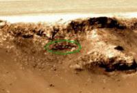
Thank you for aiding my small obsession, Stu! The best capture yet of the base of "F2". Note the part circled in green below. This may turn out to be nothing, but I can't take my eyes away from it. I no longer think it's slumped down from above, but it doesn't look like it belongs there. I'm curious if it's just a giant shadow trick or if it truly is related to what we see at the base of Cape Verde.
|
|
| Forum: Opportunity · Post Preview: #72686 · Replies: 25 · Views: 24655 |
| Posted on: Oct 10 2006, 03:11 PM | |
|
Junior Member Group: Members Posts: 52 Joined: 24-May 06 Member No.: 784 |
QUOTE (Bill Harris @ Oct 10 2006, 08:17 AM) I'll agree with your assessment 101%. I think that the capes and bays are the result of a resistant unit overlying a weaker unit being eroded by the wind. There may be a number of (not known) factors present that contribute to the regular spacing of the capes/bays but I don't think that there is any mysterious explanation. One other example of the scalloped crater form and exhumation is Erebus: Payson is a bay and the "Payson promontory" is a cape. One thing about wind erosion is that it will affect most similar outcrops around it in a similar fashion. If a symmetrical Cape & Bay system of erosion of was featured in many of the craters in the area rather than just one or two, the wind argument might er, hold more water... With the C&B features so large as what we see in Victoria, I would imagine the eroding winds would have noticible impacts on other nearby features, including the ejecta annulus of Victoria itself. Could winds so powerful as to erode those 60+ ft crater wall escarpments also leave almost no visible evidence on the ejecta annulus around Victoria? I would expect some of that ejecta to be seriously eroded away as well.We have plenty of time to look at many examples as we walk this outcrop. Or, hopefully so. --Bill |
| Forum: Opportunity · Post Preview: #72153 · Replies: 313 · Views: 198334 |
| Posted on: Oct 7 2006, 10:45 PM | |
|
Junior Member Group: Members Posts: 52 Joined: 24-May 06 Member No.: 784 |
QUOTE (lars_J @ Oct 5 2006, 11:14 PM) I find the caption on this image to be completely counter-intuitive. But keep in mind that I am a complete layperson when it comes to geology The caption imples that crater C (Endurance) once looked like A and B. But to my eye it looks rather obvious that the progression shoud be from C to B to A, as the crater erodes and is filled in by sand. But I could of course be completely wrong. Layperson or not, you're right to argue the point. I certainly don't see any "buried rim" with Victoria - I think whatever rim there was has collapsed and traces of the collapsed rock neatly covered with dust. However, I think it's too neatly covered. While wind might accomplish the C&B ["Cape & Bay] rim features we see, in this case it's quite clear that wind didn't do the bulk of the work. I'm voting for water. I'm pretty confident in this, and if I was at any conference discussing it, I'd be the last one out of the auditorium, arguing all the way. My primary reason is simple: Where did the rock from the "Bays" actually go? Small slumping/breakaway and then neatly rolling to the bottom of the crater? At the very least, we should see some decent sized blocks slumped up, perhaps peaking out from the dust at the bottom of the crater. We see some of the collapse of the "Capes" like the "F Cape". None from the "Bays". Why is that? Why no "failed bays"? I seriously doubt that rubble is going to melt away into the crater floor any time soon... or any time ever, for that matter. Unless there's water involved. There are probably three scenarios that might explain the complete lack of rock remnants from the various Bays, but the simple one works the best for me, and it's the argument I'd salute at the moment and it involves copious amounts of ground water either during or shortly after the initial impact. Seeing that there's no significant discrete ejecta rays coming out of the crater, I'm leaning to the "ground water intrusion AFTER impact" scenario. This is flawed because I have no good explanation for how the water got there with the current topography, so I'm kind of waiting for help on this one. I'm assuming since we have some ground water alteration seen elsewhere, we'll see some here. (The third scenario would involve late water incursion into the area, "melting" the rubble and that's the easiest to disprove, I think) That said, water would aid in the bay formation, and a one time slump (rather than some gradual slump and crumble over time) is evidenced by what I think we'll see upon closer examination of the walls of the Capes, starting with what we've already seen with Cape Frio. One scenario here would involve ground water seepage in and perhaps one primary zone being weak enough to collapse. That thinly layered bedding we've seen at the base of Cape Verde will be suspect #1. I sure hope we see plenty of altered basalt in that layer. However, I'm no expert on this. While I've fondled rocks for pay in the past, I've no experience with craters, terrestrial or extraterrestrial. But I'd be hard pressed to see wind be the culprit in completely eliminating all bulky rocks that slumped, and then covering the whole thing with thick dust. So, I'll go for a wet Mars on this one. |
| Forum: Opportunity · Post Preview: #71905 · Replies: 313 · Views: 198334 |
| Posted on: Oct 3 2006, 03:18 PM | |
|
Junior Member Group: Members Posts: 52 Joined: 24-May 06 Member No.: 784 |
QUOTE (climber @ Oct 2 2006, 08:39 PM) I didn't hear about this so far : There's a big chunk that apparently felt down on its "nose" and look vertical now. I find it's evident on fredk 3D there : [attachment=7857:attachment] If true that means that we have to find out WHY it has been eroded from below. What would be interesting in going there would be to see the interior of the Capes. Do you see what I mean...and what I see ? I'm a bit obsessed with the wall directly to the left of that feature and partly covered by your circle. It might be trumped by what we see in Capes B and C, but since we haven't seen those yet, I'll be over here obsessing over that little wall. |
| Forum: Opportunity · Post Preview: #71126 · Replies: 61 · Views: 51426 |
 New Replies New Replies No New Replies No New Replies Hot Topic (New) Hot Topic (New) Hot Topic (No New) Hot Topic (No New) |
 Poll (New) Poll (New) Poll (No New) Poll (No New) Locked Topic Locked Topic Moved Topic Moved Topic |

|
Lo-Fi Version | Time is now: 28th April 2024 - 09:00 PM |
|
RULES AND GUIDELINES Please read the Forum Rules and Guidelines before posting. IMAGE COPYRIGHT |
OPINIONS AND MODERATION Opinions expressed on UnmannedSpaceflight.com are those of the individual posters and do not necessarily reflect the opinions of UnmannedSpaceflight.com or The Planetary Society. The all-volunteer UnmannedSpaceflight.com moderation team is wholly independent of The Planetary Society. The Planetary Society has no influence over decisions made by the UnmannedSpaceflight.com moderators. |
SUPPORT THE FORUM Unmannedspaceflight.com is funded by the Planetary Society. Please consider supporting our work and many other projects by donating to the Society or becoming a member. |
|