Zhurong maps, traverse route and location mapping |

  |
Zhurong maps, traverse route and location mapping |
 Aug 31 2021, 12:13 AM Aug 31 2021, 12:13 AM
Post
#31
|
||
 Member  Group: Members Posts: 185 Joined: 4-January 19 Member No.: 8523 |
Amazing how detailed the orbiter get the track... a single track on Tianwen-1,.. Hirise will indeed be nice with its better resolution and seeing the 2 track path.
Attached thumbnail(s)
-------------------- "The Earth is a very small stage in a vast cosmic arena"
|
|
 |
 
|
|
|
Sep 17 2021, 05:45 PM
Post
#32
|
|||
|
Solar System Cartographer Group: Members Posts: 10226 Joined: 5-April 05 From: Canada Member No.: 227 |
We have had no news on Tianwen-1 and Zhurong for a while. The rover at least, and probably the orbiter too, are entering a superior conjunction blackout period about now. Their blackout will be longer than NASA's, probably because it's the first time they have dealt with it and will want to be more conservative.
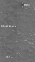
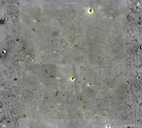
Meanwhile I wanted to show the difference between the existing map and the new Tianwen-1 orbiter image. My map is based on the published map with track and waypoints. The orbiter image shows tracks offset from it, with the offset increasing away from the lander (though the last point is close again). I suspect this is because of a small difference in the definitions of map projections between the projected orbiter image and the route map. (My coordinates are from HiRISE which opens the possibility of another offset, but in all cases I am matching to surface features using HiRISE as a standard). The maximum offset is about 10 m. Phil
-------------------- ... because the Solar System ain't gonna map itself.
Also to be found posting similar content on https://mastodon.social/@PhilStooke Maps for download (free PDF: https://upload.wikimedia.org/wikipedia/comm...Cartography.pdf NOTE: everything created by me which I post on UMSF is considered to be in the public domain (NOT CC, public domain) |
||
|
|
|
||
|
Sep 18 2021, 01:51 PM
Post
#33
|
|
|
Senior Member Group: Members Posts: 3008 Joined: 30-October 04 Member No.: 105 |
Agreed. The 'quiet spell' from Zhurong is not to be worried about. They don't have an as-established DSN infrastructure or as much experience with dealing with a faint, noisy signal.
I'm still impressed with their Rover's track. I don't know how on-course it is, but it doesn't seem to be bumping into things... --Bill -------------------- |
|
|
|
|
Nov 8 2021, 08:09 PM
Post
#34
|
||
|
Solar System Cartographer Group: Members Posts: 10226 Joined: 5-April 05 From: Canada Member No.: 227 |
Here is an update to my map (section 2) based on this site:
https://mp.weixin.qq.com/s/NImpyH43GAhMnF0dkpU1jA (thanks to Andrew Jones for tweeting about it). I have not yet corrected it to fit the tracks seen in orbital images. I will wait for a new HiRISE image to do that. Phil
-------------------- ... because the Solar System ain't gonna map itself.
Also to be found posting similar content on https://mastodon.social/@PhilStooke Maps for download (free PDF: https://upload.wikimedia.org/wikipedia/comm...Cartography.pdf NOTE: everything created by me which I post on UMSF is considered to be in the public domain (NOT CC, public domain) |
|
|
|
|
|
|
Dec 24 2021, 09:26 AM
Post
#35
|
||
 Member Group: Members Posts: 349 Joined: 20-June 07 From: Slovenia Member No.: 2461 |
Recently new geological map for Zhurong landing site was made available in this artilcle: https://doi.org/10.1016/j.icarus.2021.114657. I turned their data into this map using same symbology and adding some new IAU approved feature names. |
|
|
|
|
|
|
Dec 24 2021, 09:30 AM
Post
#36
|
||
|
Member Group: Members Posts: 349 Joined: 20-June 07 From: Slovenia Member No.: 2461 |
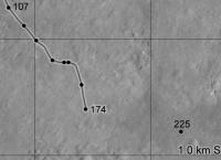
Sol 174 map update. |
|
|
|
|
|
|
Jan 1 2022, 08:10 AM
Post
#37
|
||
|
Solar System Cartographer Group: Members Posts: 10226 Joined: 5-April 05 From: Canada Member No.: 227 |
A very quick look at the end of year location. The new partial panorama is looking southeast and it leads to this position. I will post a proper map when I can get to it.
Phil
-------------------- ... because the Solar System ain't gonna map itself.
Also to be found posting similar content on https://mastodon.social/@PhilStooke Maps for download (free PDF: https://upload.wikimedia.org/wikipedia/comm...Cartography.pdf NOTE: everything created by me which I post on UMSF is considered to be in the public domain (NOT CC, public domain) |
|
|
|
|
|
|
Jan 4 2022, 02:23 PM
Post
#38
|
|||
|
Member Group: Members Posts: 349 Joined: 20-June 07 From: Slovenia Member No.: 2461 |
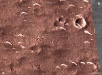
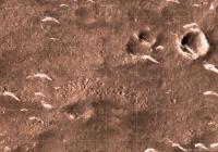
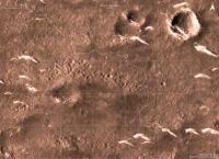
Sol 201 update in IRG color, based on latest image from Zhurong. The rover itself has already moved a little further to the SE since.
3D perspective based on HiRise terrain model, with roughly the same perspective as published image. |
||
|
|
|
||
|
Jan 4 2022, 09:22 PM
Post
#39
|
|
|
Solar System Cartographer Group: Members Posts: 10226 Joined: 5-April 05 From: Canada Member No.: 227 |
I assumed the partial panorama was from the end of year date, but if it is from sol 201 I will correct my map. I am still hoping for a new HiRISE image to guide my next map. There are small differences beteen the various sources we have.
Phil -------------------- ... because the Solar System ain't gonna map itself.
Also to be found posting similar content on https://mastodon.social/@PhilStooke Maps for download (free PDF: https://upload.wikimedia.org/wikipedia/comm...Cartography.pdf NOTE: everything created by me which I post on UMSF is considered to be in the public domain (NOT CC, public domain) |
|
|
|
|
Jan 5 2022, 02:51 AM
Post
#40
|
|
|
Senior Member Group: Members Posts: 3008 Joined: 30-October 04 Member No.: 105 |
QUOTE (kymani76 @ Jan 4 2022, 09:23 AM)  attachment=50066:tianwen1...201_r001.jpg Sol 201 update in IRG color, based on latest image from Zhurong. The rover itself has already moved a little further to the SE since. attachment=50067:tianwen1..._3D_r001.jpg 3D perspective based on HiRise terrain model, with roughly the same perspective as published image. They are avoiding driving over that patch of pitted terrain, but hopefully will stop for a closer look. Nice 3D perspective! --Bill -------------------- |
|
|
|
|
Jan 5 2022, 08:03 PM
Post
#41
|
|
|
Member Group: Members Posts: 349 Joined: 20-June 07 From: Slovenia Member No.: 2461 |
QUOTE (Bill Harris @ Jan 5 2022, 03:51 AM) They are avoiding driving over that patch of pitted terrain, but hopefully will stop for a closer look. Nice 3D perspective! --Bill Thank you, Jaka |
|
|
|
|
Mar 15 2022, 04:34 PM
Post
#42
|
||
|
Member Group: Members Posts: 349 Joined: 20-June 07 From: Slovenia Member No.: 2461 |
Preliminary sol 262 map update, based on this map found here. I have no other source of info, but I'm sure the track distances on this map don't add up. |
|
|
|
|
|
|
Mar 22 2022, 12:25 PM
Post
#43
|
||
|
Member Group: Members Posts: 349 Joined: 20-June 07 From: Slovenia Member No.: 2461 |
Recent article characterizing first 60 sols of Zhurong traverse was published in Nature Geoscience.
While the article is sadly behind paywall it is possible to download supplemental files which include rover's track points. Here is a comparison map of my version of traverse vs the new track points in red:
|
|
|
|
|
|
|
Mar 24 2022, 04:44 PM
Post
#44
|
|||
|
Member Group: Members Posts: 349 Joined: 20-June 07 From: Slovenia Member No.: 2461 |
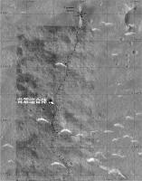
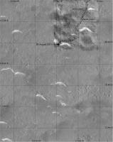
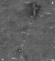
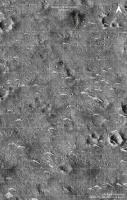
Zhurong traverse updated with track visible in new HiRise photo ESP_073225_2055.
I also updated positions for sols 0-60 with date mentioned in previous post and manage to extend coverage to sol 75. Sols after that are approximate. The Chinese data veers off course to the east when compared to track visible in HiRise photo, so I corrected its position to nearest point in the track.
1. Whole track from the landing 2. Zoom in to the latest sol 297(?) position on 03/11/2022. |
||
|
|
|
||
|
Mar 24 2022, 04:48 PM
Post
#45
|
||
|
Member Group: Members Posts: 349 Joined: 20-June 07 From: Slovenia Member No.: 2461 |
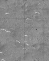
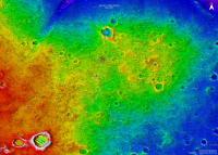
In addition I also made elevation map with the new track plotted. It seems like Zhurong landed on "peninsula" and is headed to the "beach" now. |
|
|
|
|
|
|

|
Lo-Fi Version | Time is now: 23rd September 2024 - 08:03 PM |
|
RULES AND GUIDELINES Please read the Forum Rules and Guidelines before posting. IMAGE COPYRIGHT |
OPINIONS AND MODERATION Opinions expressed on UnmannedSpaceflight.com are those of the individual posters and do not necessarily reflect the opinions of UnmannedSpaceflight.com or The Planetary Society. The all-volunteer UnmannedSpaceflight.com moderation team is wholly independent of The Planetary Society. The Planetary Society has no influence over decisions made by the UnmannedSpaceflight.com moderators. |
SUPPORT THE FORUM Unmannedspaceflight.com is funded by the Planetary Society. Please consider supporting our work and many other projects by donating to the Society or becoming a member. |
|