Spirit retrospective, - a few details from my current project |

  |
Spirit retrospective, - a few details from my current project |
 Jan 20 2012, 09:13 PM Jan 20 2012, 09:13 PM
Post
#1
|
||
|
Solar System Cartographer  Group: Members Posts: 10164 Joined: 5-April 05 From: Canada Member No.: 227 |
I'm working on Spirit at the moment. I will post a few examples of things as I go.
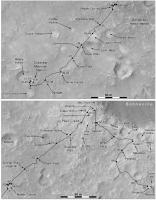
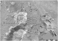
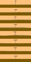
Right now the important job is updating the contemporary route map by locating the stops on HiRISE images. The existing maps at JPL, for the early part of the mission, were plotted on MOC images with inferior resolution and lighting, so I find many locations were about 15 or 20 m out. So at every site I am making circular panoramas (examples later) for comparison with HiRISE. Here's a first example, a map of the route during the Primary Mission. I have added a few extra placenames from the MER Analyst's Notebook at PDS. Phil
-------------------- ... because the Solar System ain't gonna map itself.
Also to be found posting similar content on https://mastodon.social/@PhilStooke Maps for download (free PD: https://upload.wikimedia.org/wikipedia/comm...Cartography.pdf NOTE: everything created by me which I post on UMSF is considered to be in the public domain (NOT CC, public domain) |
|
 |
 
|
|
|
Jan 20 2012, 09:35 PM
Post
#2
|
|
 Member Group: Members Posts: 700 Joined: 3-December 04 From: Boulder, Colorado, USA Member No.: 117 |
Gorgeous! Are these for a book?
John |
|
|
|
|
Jan 20 2012, 10:22 PM
Post
#3
|
|
 Member Group: Members Posts: 655 Joined: 22-January 06 Member No.: 655 |
I like that a lot Phil - very nice.
There seems to be a trend in many space/astronomy magazine articles and books for over-doing the colour. If it is for a book, please leave it grayscale - it looks more crisp and authoritative imho. I look forward to future posts on your progress. |
|
|
|
|
Jan 20 2012, 11:00 PM
Post
#4
|
|
|
Merciless Robot Group: Admin Posts: 8784 Joined: 8-December 05 From: Los Angeles Member No.: 602 |
VERY nice work, Phil!!!!
-------------------- A few will take this knowledge and use this power of a dream realized as a force for change, an impetus for further discovery to make less ancient dreams real.
|
|
|
|
|
Jan 20 2012, 11:26 PM
Post
#5
|
|
|
Solar System Cartographer Group: Members Posts: 10164 Joined: 5-April 05 From: Canada Member No.: 227 |
-------------------- ... because the Solar System ain't gonna map itself.
Also to be found posting similar content on https://mastodon.social/@PhilStooke Maps for download (free PD: https://upload.wikimedia.org/wikipedia/comm...Cartography.pdf NOTE: everything created by me which I post on UMSF is considered to be in the public domain (NOT CC, public domain) |
|
|
|
|
Jan 21 2012, 06:47 AM
Post
#6
|
|
|
Member Group: Members Posts: 295 Joined: 2-March 04 From: Central California Member No.: 45 |
I wonder if they regret not going around Bonneville to the heat shield. Spirit could have easily made the trip and may have avoided the problem with the wheel that started around sol 125 when making the trek to the hills. Seeing this map reminded me of those heady early days when you had no idea how far they would take Spirit.
-------------------- Eric P / MizarKey
|
|
|
|
|
Jan 21 2012, 07:27 AM
Post
#7
|
|
|
Founder Group: Chairman Posts: 14432 Joined: 8-February 04 Member No.: 1 |
How would driving to the heatshield have avoided the wheel problem?
Giving the information available at the time, sprinting to the hills was clearly the right decision to make. |
|
|
|
|
Jan 21 2012, 02:53 PM
Post
#8
|
|
 Senior Member Group: Admin Posts: 4763 Joined: 15-March 05 From: Glendale, AZ Member No.: 197 |
QUOTE (djellison @ Jan 20 2012, 11:27 PM)  Giving the information available at the time, sprinting to the hills was clearly the right decision to make. Given the information we have today it was still the right decision to make. I would also venture that the experience with Spirit's wheel allowed the team to understand the malfunction and take steps to avoid the same with Opportunity on her epic trek. -------------------- If Occam had heard my theory, things would be very different now.
|
|
|
|
|
Jan 21 2012, 04:27 PM
Post
#9
|
|
 Senior Member Group: Members Posts: 2173 Joined: 28-December 04 From: Florida, USA Member No.: 132 |
And don't forget that Spirit made some fantastic discoveries because of that stuck wheel. Particularly the subsurface silica layer.
|
|
|
|
|
Jan 21 2012, 04:52 PM
Post
#10
|
|
|
Member Group: Members Posts: 808 Joined: 10-October 06 From: Maynard Mass USA Member No.: 1241 |
(1) Having Spirit driving to its crumbled heat-shield on Bonneville and the eventual wheel failure, are not related
(2) The heat-shield, while visually interesting to us (a man made object on mars!), was smashed up on the rocks and of no real value to the engineers. They could get the same results by dropping a copy over the desert in CA (3) As we learned with OPPY, the heat-shield is a lingering source of volatiles that are not good for scientific instruments (3) Scooting to the hills was the right exploration decision. Here is Spririt's crumbled heat-shield (super res): http://www.unmannedspaceflight.com/index.p...st&id=10115 -------------------- CLA CLL
|
|
|
|
|
Jan 21 2012, 05:07 PM
Post
#11
|
|
|
Founder Group: Chairman Posts: 14432 Joined: 8-February 04 Member No.: 1 |
QUOTE (PDP8E @ Jan 21 2012, 08:52 AM) (2) The heat-shield, while visually interesting to us (a man made object on mars!), was smashed up on the rocks and of no real value to the engineers. They could get the same results by dropping a copy over the desert in CA Actually- that's not true. The engineers who looked at the Opportunity heatshield did get some value out of it. If it was of no real value to the engineers - then the geologists in charge would not have stopped to look at it at Meridiani. |
|
|
|
|
Feb 4 2012, 12:14 AM
Post
#12
|
|
|
Member Group: Members Posts: 866 Joined: 15-March 05 From: Santa Cruz, CA Member No.: 196 |
imho, the wreck of Oppy's heatshield was one of the most interesting stops between Endurance and Victoria. Engineers could analyse for the first time the performance of the ablative material, etc in situ, though i dont know what ever came out of that.. maybe just confirmation they didnt need to change a thing 'hmm yep, it did its job as expected!' not to mention lots of fascinating images of crumpled metal, freshly disturbed soil, remnants of destroyed spacecraft, broken springs and all so curiously tossed asunder manmade derelict debris in such an alien humanless landscape, unforgettable..
|
|
|
|
|
Feb 4 2012, 08:44 AM
Post
#13
|
|
|
Senior Member Group: Members Posts: 2920 Joined: 14-February 06 From: Very close to the Pyrénées Mountains (France) Member No.: 682 |
Rob Manning recentely wrote about this here (i think) but I'm not able to find what he said. Anybody read this?
-------------------- |
|
|
|
|
Feb 4 2012, 03:29 PM
Post
#14
|
|
|
Senior Member Group: Members Posts: 2173 Joined: 28-December 04 From: Florida, USA Member No.: 132 |
QUOTE (climber @ Feb 4 2012, 03:44 AM) Rob Manning recentely wrote about this here... From these two posts in the same thread: Here and here."Indeed there was a lot of concern when we drove Opportunity to its heatshield after landing (at my and my team's behest). We wanted to learn more about the heatshield performance (we learned a lot!)." "Unfortunately, while the rover was near the heatshield, apparently wind picked up some particulates that got onto the rear Hazcam lenses. It may have been a coincidence and it was only Mars dust but more probably it was char from the heatshield that the wind blew onto the lenses." "In summary we concluded that the char depth of the heat shield material matched our predictions (yea!). We also learned that a piece of a mylar blanket that skirted the heat shield became a "flap" that induced some minor but very noticeable wiggles of the entry vehicle (capsule) during Opportunity's entry just before parachute deployment. The blanket was supposed to fully melt away during entry but we found that part of it did not (it was on Mars still attached to the crumpled heat shield). Its position and size matched our entry dynamic simulations for a flapping flap. Needless to say MSL does not have a blanket covering its heat shield (neither did Phoenix)." |
|
|
|
|
Feb 6 2012, 05:43 PM
Post
#15
|
||
|
Solar System Cartographer Group: Members Posts: 10164 Joined: 5-April 05 From: Canada Member No.: 227 |
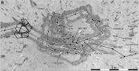
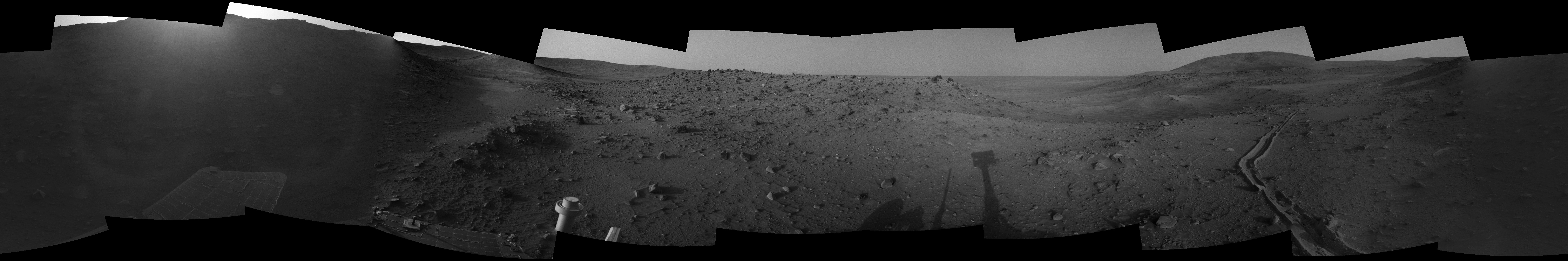
Here's another example of recent work. Hank's Hollow. I may be revising the route a bit but this is tied to the images as much as possible.
Phil
-------------------- ... because the Solar System ain't gonna map itself.
Also to be found posting similar content on https://mastodon.social/@PhilStooke Maps for download (free PD: https://upload.wikimedia.org/wikipedia/comm...Cartography.pdf NOTE: everything created by me which I post on UMSF is considered to be in the public domain (NOT CC, public domain) |
|
|
|
|
|
|
Feb 6 2012, 05:55 PM
Post
#16
|
||
|
Solar System Cartographer Group: Members Posts: 10164 Joined: 5-April 05 From: Canada Member No.: 227 |
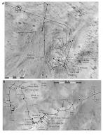
... and a comparison of project mapping and my new map a little west of West Spur. This is a slide for a presentation I'm giving here in London on Feb. 17th.
The orange line is the project map based on 'dead reckoning' with occasional ties to landscape features seen in MOC images. Dead reckoning includes knowing the intended direction and using the wheel turns to estimate distance. The ties to topography were necessarily approximate because of the limited resolution of MOC (how amazing it is to be saying that - grown men wept at the beauty of the MOC images at the time, now they are of limited resolution!) A few points found by feature matching are shown as crosses on or near the route. My route is the black line. It follows the route quite well, but actual end of drive locations are often out by 15 to 30 m along the route. These locations are matched to individual boulders and I would stake what remains of my reputation on their accuracy... most of the time! The square grid is at 100 m spacing. Phil
-------------------- ... because the Solar System ain't gonna map itself.
Also to be found posting similar content on https://mastodon.social/@PhilStooke Maps for download (free PD: https://upload.wikimedia.org/wikipedia/comm...Cartography.pdf NOTE: everything created by me which I post on UMSF is considered to be in the public domain (NOT CC, public domain) |
|
|
|
|
|
|
Mar 4 2012, 03:05 PM
Post
#17
|
||
|
Solar System Cartographer Group: Members Posts: 10164 Joined: 5-April 05 From: Canada Member No.: 227 |
Another little detail from long ago and far away...
Phil -------------------- ... because the Solar System ain't gonna map itself.
Also to be found posting similar content on https://mastodon.social/@PhilStooke Maps for download (free PD: https://upload.wikimedia.org/wikipedia/comm...Cartography.pdf NOTE: everything created by me which I post on UMSF is considered to be in the public domain (NOT CC, public domain) |
|
|
|
|
|
|
Mar 5 2012, 05:24 AM
Post
#18
|
|
 Administrator Group: Admin Posts: 5172 Joined: 4-August 05 From: Pasadena, CA, USA, Earth Member No.: 454 |
Speaking of Spirit retrospective, we (that is, the Society) are thinking about trying to gather Salley's MER Updates into an easier-to-access form, like maybe a PDF (or several PDFs; she's written several novels' worth of words about the MERs). But this would be a fair (by which I mean gargantuan) amount of work cutting and pasting. Would there be anyone here interested in donating time to such a project?
-------------------- My website - My Patreon - @elakdawalla on Twitter - Please support unmannedspaceflight.com by donating here.
|
|
|
|
|
Mar 5 2012, 03:31 PM
Post
#19
|
|
|
Solar System Cartographer Group: Members Posts: 10164 Joined: 5-April 05 From: Canada Member No.: 227 |
Right now those reports are spread out among lots of other pages and they take some tracking down. Maybe all you need is one page for each rover providing links to all the existing reports.
Phil -------------------- ... because the Solar System ain't gonna map itself.
Also to be found posting similar content on https://mastodon.social/@PhilStooke Maps for download (free PD: https://upload.wikimedia.org/wikipedia/comm...Cartography.pdf NOTE: everything created by me which I post on UMSF is considered to be in the public domain (NOT CC, public domain) |
|
|
|
|
Apr 16 2012, 07:22 PM
Post
#20
|
||
|
Solar System Cartographer Group: Members Posts: 10164 Joined: 5-April 05 From: Canada Member No.: 227 |
Time for another blast from ye olde past: Spirit at Low Ridge Haven.
Phil -------------------- ... because the Solar System ain't gonna map itself.
Also to be found posting similar content on https://mastodon.social/@PhilStooke Maps for download (free PD: https://upload.wikimedia.org/wikipedia/comm...Cartography.pdf NOTE: everything created by me which I post on UMSF is considered to be in the public domain (NOT CC, public domain) |
|
|
|
|
|
|
May 27 2012, 05:35 PM
Post
#21
|
||
|
Solar System Cartographer Group: Members Posts: 10164 Joined: 5-April 05 From: Canada Member No.: 227 |
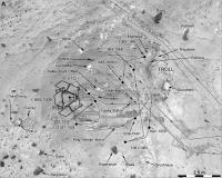
A final blast from ye olde past at Spirit's site... I've pretty much finished the image part of Spirit's journey and I'm working on the sol-by-sol text. This is a close view of the main targets of study at Troy before the end of the mission. Much more information on target names and locations will be released soon and I will be adding to the existing maps where appropriate. Meanwhile mapping is beginning at Meridiani.
Phil
-------------------- ... because the Solar System ain't gonna map itself.
Also to be found posting similar content on https://mastodon.social/@PhilStooke Maps for download (free PD: https://upload.wikimedia.org/wikipedia/comm...Cartography.pdf NOTE: everything created by me which I post on UMSF is considered to be in the public domain (NOT CC, public domain) |
|
|
|
|
|
|
May 27 2012, 05:55 PM
Post
#22
|
||
|
Solar System Cartographer Group: Members Posts: 10164 Joined: 5-April 05 From: Canada Member No.: 227 |
One other goodie. On sol 620 Spirit was on the summit of Husband Hill, taking a big panorama. This subframe is looking due east with three horizons visible - the near rim of Thira crater, the far rim of Thira, and in the distance the rim of Gusev itself. And in front of Thira is a towering dust devil. We normally see these DD images with the sky brightened enough to reveal the DD on the ground, overexposing anything in the sky. Here (from the 16 bit data) is the full vertical extent (cropped by the top of the frame). I found it while making a full mosaic of the rim of Gusev.
Phil
-------------------- ... because the Solar System ain't gonna map itself.
Also to be found posting similar content on https://mastodon.social/@PhilStooke Maps for download (free PD: https://upload.wikimedia.org/wikipedia/comm...Cartography.pdf NOTE: everything created by me which I post on UMSF is considered to be in the public domain (NOT CC, public domain) |
|
|
|
|
|
|
Jun 3 2012, 03:36 PM
Post
#23
|
||
|
Solar System Cartographer Group: Members Posts: 10164 Joined: 5-April 05 From: Canada Member No.: 227 |
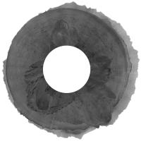
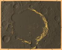
That last image was from a new study of the rim of Gusev from the pan shot at Everest (Husband Hill Absolute Summit) on sols 620-622. Here is the full panorama turned into a circle. The rim of Gusev has been subjected to an extreme contrast enhancement relative to the near horizon, resulting in artifacts in places. But I think the distant rim has never been seen so fully. Clearer views of small parts of it were obtained from West Spur, but this is the best look at the whole thing. The processing was done from the 16 bit images at PDS. I am working on an identification of features and will post it later, but I think the most interesting thing is the view of the large flat-topped mesas south of the rover, at the supposed Ma'adim Vallis delta, and the hills beyond which extend up the valley a bit inside the breached crater New Plymouth. Vertical exaggeration at the horizon is 5.5x.
Phil
-------------------- ... because the Solar System ain't gonna map itself.
Also to be found posting similar content on https://mastodon.social/@PhilStooke Maps for download (free PD: https://upload.wikimedia.org/wikipedia/comm...Cartography.pdf NOTE: everything created by me which I post on UMSF is considered to be in the public domain (NOT CC, public domain) |
|
|
|
|
|
|
Jun 3 2012, 04:34 PM
Post
#24
|
|
|
Senior Member Group: Members Posts: 3516 Joined: 4-November 05 From: North Wales Member No.: 542 |
Very nice Phil!
 As it happens I've recently been thinking back to some long ago discussion on who-knows-which thread about some even more distant horizon features that could be seen through a gap in the Gusev rim. Is that visible on this panorama? If so where, and if not where's the location? I would like to revisit the precise identity of what may have been the most distant features seen by either rover. I wasn't paying enough attention at the time, but I don't think it was nailed down as thoroughly as it could have been, or could be now with Google Earth Mars or James Canvin-type reverse polar plots, or pgrindrod inter-visibility charts. |
|
|
|
|
Jun 3 2012, 08:11 PM
Post
#25
|
|
|
Solar System Cartographer Group: Members Posts: 10164 Joined: 5-April 05 From: Canada Member No.: 227 |
I don't remember that. If it was seen before it should be seen here. Can anyone find that discussion?
Phil -------------------- ... because the Solar System ain't gonna map itself.
Also to be found posting similar content on https://mastodon.social/@PhilStooke Maps for download (free PD: https://upload.wikimedia.org/wikipedia/comm...Cartography.pdf NOTE: everything created by me which I post on UMSF is considered to be in the public domain (NOT CC, public domain) |
|
|
|
|
Jun 3 2012, 08:52 PM
Post
#26
|
||
|
Solar System Cartographer Group: Members Posts: 10164 Joined: 5-April 05 From: Canada Member No.: 227 |
Sightlines plotted on a merge of THEMIS IR data (with inverted shading) and MOLA topography. This is a first attempt, but I may have to make some adjustments.
Phil (EDIT - replaced original with an improved version)
-------------------- ... because the Solar System ain't gonna map itself.
Also to be found posting similar content on https://mastodon.social/@PhilStooke Maps for download (free PD: https://upload.wikimedia.org/wikipedia/comm...Cartography.pdf NOTE: everything created by me which I post on UMSF is considered to be in the public domain (NOT CC, public domain) |
|
|
|
|
|
|
Jun 3 2012, 09:14 PM
Post
#27
|
|
|
Senior Member Group: Members Posts: 3516 Joined: 4-November 05 From: North Wales Member No.: 542 |
It looks like it's on that line you've drawn at about half past five. If that's correct there's not much doubt about the identification. The horizon is one smaller crater-width further away. But how far is that? How does the distance compare with the Miyamoto rim peaks ('Mule Ears') seen by Opportunity?
Find the discussion - now that's a challenge. I'll have a go. |
|
|
|
|
Jun 3 2012, 09:47 PM
Post
#28
|
|
|
Senior Member Group: Members Posts: 3516 Joined: 4-November 05 From: North Wales Member No.: 542 |
Phil, can you put a scale on that image?
|
|
|
|
|
Jun 3 2012, 09:59 PM
Post
#29
|
|
 Senior Member Group: Members Posts: 4247 Joined: 17-January 05 Member No.: 152 |
There was some related discussion in this thread many many years ago...
|
|
|
|
|
Jun 3 2012, 11:06 PM
Post
#30
|
|
|
Solar System Cartographer Group: Members Posts: 10164 Joined: 5-April 05 From: Canada Member No.: 227 |
"Phil, can you put a scale on that image?"
Now I have replaced the previous image with one with a scale! Phil -------------------- ... because the Solar System ain't gonna map itself.
Also to be found posting similar content on https://mastodon.social/@PhilStooke Maps for download (free PD: https://upload.wikimedia.org/wikipedia/comm...Cartography.pdf NOTE: everything created by me which I post on UMSF is considered to be in the public domain (NOT CC, public domain) |
|
|
|
|
Jun 4 2012, 08:51 AM
Post
#31
|
|
|
Senior Member Group: Members Posts: 3516 Joined: 4-November 05 From: North Wales Member No.: 542 |
Thanks Phil and fredk. Unfortunately the links in the old thread no longer seem to work so I'm still not sure how thoroughly and securely distant horizon features were identified back then. First impression is that Spirit's visibility range probably exceeded Opportunity's Miyamoto sighting in several directions, though only by a few km. If she broke the 100km mark anywhere it was most likely to the S but it's not possible to tell without closer scrutiny of the terrain out there.
|
|
|
|
|
Jun 4 2012, 02:17 PM
Post
#32
|
|
|
Solar System Cartographer Group: Members Posts: 10164 Joined: 5-April 05 From: Canada Member No.: 227 |
Yes, it's sad to go back and see all the things that have disappeared.
Phil -------------------- ... because the Solar System ain't gonna map itself.
Also to be found posting similar content on https://mastodon.social/@PhilStooke Maps for download (free PD: https://upload.wikimedia.org/wikipedia/comm...Cartography.pdf NOTE: everything created by me which I post on UMSF is considered to be in the public domain (NOT CC, public domain) |
|
|
|
|
Jun 4 2012, 03:54 PM
Post
#33
|
|
|
Founder Group: Chairman Posts: 14432 Joined: 8-February 04 Member No.: 1 |
Imagehost, XS and others have all gone away or have a policy of deleting older content. It's a shame, but that's the risk you run with free hosting facilities.
|
|
|
|
|
Jun 9 2012, 03:21 PM
Post
#34
|
|||
|
Senior Member Group: Members Posts: 4247 Joined: 17-January 05 Member No.: 152 |
If anyone's curious, here are a couple of the images from that old thread, resurrected from the cobwebby depths of my harddrive:
Those are the only Gusev rim related pics I kept from that thread. It is a shame indeed about the hosting site. Even more so since these images were tiny - there was no reason not to put them on UMSF in the first place! |
||
|
|
|
||
|
Jun 9 2012, 04:01 PM
Post
#35
|
|
|
Senior Member Group: Members Posts: 3516 Joined: 4-November 05 From: North Wales Member No.: 542 |
Well rescued!
There's all the information I was after right there - a useful complement/comparison with Phil's excellent summit pan.
|
|
|
|
|
Jun 9 2012, 07:17 PM
Post
#36
|
|||
|
Senior Member Group: Members Posts: 4247 Joined: 17-January 05 Member No.: 152 |
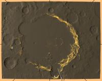
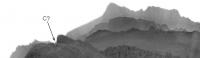
So as far as seeing outside of Gusev, I've marked three locations on the view map:
We can clearly see the far rim of the smaller crater (New Plymouth?) at A. This map predicts that we should be able to see a bit farther to another smaller crater rim at B, but it's not clear to me whether we can see that in Phil's horizon pan or not. I also wonder whether we can see some uncertain distance up Ma'adim Vallis to perhaps one of its walls, towards C. That would be somewhere around here on Phil's pan:
Unfortunately part of the Columbia Hills is in the way. But maybe there are pancam images that were taken from farther west (on approach to the summit) that would be unobstructed? Phil: any chance you could post your original rectangular horizon pan at full res? Perhaps cropping out the foreground if the filesize is too big? |
||
|
|
|
||
|
Jun 9 2012, 07:35 PM
Post
#37
|
|
|
Solar System Cartographer Group: Members Posts: 10164 Joined: 5-April 05 From: Canada Member No.: 227 |
Will do when I get to the office on Monday.
Phil -------------------- ... because the Solar System ain't gonna map itself.
Also to be found posting similar content on https://mastodon.social/@PhilStooke Maps for download (free PD: https://upload.wikimedia.org/wikipedia/comm...Cartography.pdf NOTE: everything created by me which I post on UMSF is considered to be in the public domain (NOT CC, public domain) |
|
|
|
|
Jun 9 2012, 09:31 PM
Post
#38
|
|
|
Senior Member Group: Members Posts: 3516 Joined: 4-November 05 From: North Wales Member No.: 542 |
QUOTE (fredk @ Jun 9 2012, 08:17 PM) We can clearly see the far rim of the smaller crater (New Plymouth?) at A. This map predicts that we should be able to see a bit farther to another smaller crater rim at B, but it's not clear to me whether we can see that in Phil's horizon pan or not. B would, I think, break 100km but I wouldn't be surprised if it's not actually visible. If I remember rightly pgrindrod's visibility maps neglected the curvature of Mars. He was mainly concerned with closer features so that was fair enough. There's no way of knowing whether this one does or not. It's worth a thorough look though. C: The view down the valley is definitely worth exploring in detail. If the most distant point on the horizon lies in that direction it should be possible to pinpoint the location and distance with the information available. |
|
|
|
|
Jun 9 2012, 09:39 PM
Post
#39
|
|
|
Senior Member Group: Members Posts: 4247 Joined: 17-January 05 Member No.: 152 |
QUOTE (ngunn @ Jun 9 2012, 10:31 PM) There's no way of knowing whether this one does or not. From the first post by erwin in that old thread:QUOTE I use 128 pixel/degrees data, cropped gusev area, sphericise the heights according to Mars diameter. So it seems he did take curvature into account.Also, he says he cropped on Gusev, so any distant far wall of the Vallis may be outside of his cropped region. So his rendering of the C region may not show a distant wall that's actually visible... |
|
|
|
|
Jun 10 2012, 01:03 PM
Post
#40
|
|
|
Solar System Cartographer Group: Members Posts: 10164 Joined: 5-April 05 From: Canada Member No.: 227 |
One other thing which I have not done yet... these images were part of the Everest panorama taken on sols 620-622, and it was multispectral. Some bands were subsampled images but three were full resolution. So it would be possible to take all three full res bands at 16 bit from PDS and stretch to optimize the distant features, and then merge them to increase signal. That might help reveal details on the distant rim.
Phil -------------------- ... because the Solar System ain't gonna map itself.
Also to be found posting similar content on https://mastodon.social/@PhilStooke Maps for download (free PD: https://upload.wikimedia.org/wikipedia/comm...Cartography.pdf NOTE: everything created by me which I post on UMSF is considered to be in the public domain (NOT CC, public domain) |
|
|
|
|
Jun 11 2012, 02:25 PM
Post
#41
|
||
|
Solar System Cartographer Group: Members Posts: 10164 Joined: 5-April 05 From: Canada Member No.: 227 |
OK, here is a cropped version of my full horizon panorama. It's quite dirty, and got cleaned up quite a bit for the circular view. It really is quite hard to pull out that very faint detail.
Phil
-------------------- ... because the Solar System ain't gonna map itself.
Also to be found posting similar content on https://mastodon.social/@PhilStooke Maps for download (free PD: https://upload.wikimedia.org/wikipedia/comm...Cartography.pdf NOTE: everything created by me which I post on UMSF is considered to be in the public domain (NOT CC, public domain) |
|
|
|
|
|
|
Jun 11 2012, 04:47 PM
Post
#42
|
|
|
Member Group: Members Posts: 655 Joined: 22-January 06 Member No.: 655 |
That's awesome!!
|
|
|
|
|
Jun 11 2012, 05:20 PM
Post
#43
|
|
|
Solar System Cartographer Group: Members Posts: 10164 Joined: 5-April 05 From: Canada Member No.: 227 |
Ugliest pan ever!
Phil -------------------- ... because the Solar System ain't gonna map itself.
Also to be found posting similar content on https://mastodon.social/@PhilStooke Maps for download (free PD: https://upload.wikimedia.org/wikipedia/comm...Cartography.pdf NOTE: everything created by me which I post on UMSF is considered to be in the public domain (NOT CC, public domain) |
|
|
|
|
Jun 11 2012, 08:01 PM
Post
#44
|
|
|
Member Group: Members Posts: 194 Joined: 3-January 10 Member No.: 5156 |
QUOTE (Phil Stooke @ Jun 11 2012, 07:20 PM) Ugliest pan ever! No, it is just one of the best panoramas ever seen on Mars, Thx for it! -------------------- Need more input ...
|
|
|
|
|
Jun 11 2012, 08:55 PM
Post
#45
|
|
 Member Group: Members Posts: 796 Joined: 27-February 08 From: Heart of Europe Member No.: 4057 |
Cool, ugly panorama!
 So many peaks everywhere! -------------------- |
|
|
|
|
Jun 11 2012, 11:18 PM
Post
#46
|
|
|
Junior Member Group: Members Posts: 57 Joined: 22-March 09 From: West Hartford, Connecicut Member No.: 4691 |
Amazing even if it is ugly
|
|
|
|
|
Jun 12 2012, 05:11 AM
Post
#47
|
|
 Senior Member Group: Admin Posts: 3108 Joined: 21-December 05 From: Canberra, Australia Member No.: 615 |
Just a little side note...
Today would have marked Spirit's 3000th Sol on Mars had she still been operational 
|
|
|
|
|
Jul 9 2012, 10:55 PM
Post
#48
|
|||
|
Senior Member Group: Members Posts: 4247 Joined: 17-January 05 Member No.: 152 |
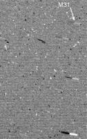
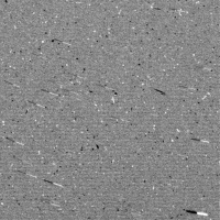
QUOTE (Deimos @ Jul 6 2012, 03:07 PM) We also got Andromeda--it was barely detectable in the largest practical exposures. QUOTE (Deimos @ Jul 7 2012, 05:19 PM) I believe it was A/1941, night time opacity field A (aka the "diffuse sensitivity test"). (I hope Phil doesn't mind me using his thread to do some Spirit retrospection - this definitely doesn't belong in the Oppy thread where those quotes come from.) Thanks for digging that up, Deimos. "Barely detectable" is a good description! With some effort I was able to squeeze the Andromeda Galaxy/M31 out of the 1941 pics. If anyone wants to try this at home, here are the details: I used these two frames: 2P298641880EFFB1E5P2731L1M1.JPG (frame 1) 2P298642075EFFB1E5P2731L1M1.JPG (frame 2) I added 256 to the frame 2 values, then subtracted frame 1. The result was stretched and smoothed. (Strangely, the PDS RAD images show less detail than the jpl jpegs.) The result is that most of the frame averages to neutral grey. Any real object (eg a star) will appear as a lighter-than-neutral-grey streak adjacent to a darker streak, which stands out very well. I've identified M31 in this crop:
It's clearly fuzzier than the stars, and it is exactly where it should be, as you can see from this flicker gif comparing the difference image with a star chart:
Extragalactic imaging from Mars! 
|
||
|
|
|
||
|
Jul 9 2012, 11:45 PM
Post
#49
|
|
|
Solar System Cartographer Group: Members Posts: 10164 Joined: 5-April 05 From: Canada Member No.: 227 |
It's not my thread! It belongs to all of us. Thanks for this - very nice.
Phil -------------------- ... because the Solar System ain't gonna map itself.
Also to be found posting similar content on https://mastodon.social/@PhilStooke Maps for download (free PD: https://upload.wikimedia.org/wikipedia/comm...Cartography.pdf NOTE: everything created by me which I post on UMSF is considered to be in the public domain (NOT CC, public domain) |
|
|
|
|
Jul 11 2012, 04:33 AM
Post
#50
|
|
 Senior Member Group: Members Posts: 2228 Joined: 1-December 04 From: Marble Falls, Texas, USA Member No.: 116 |
Yes, very nice work, Fred. Thanks.
-------------------- ...Tom
I'm not a Space Fan, I'm a Space Exploration Enthusiast. |
|
|
|
|
Mar 8 2013, 10:34 PM
Post
#51
|
|
|
Solar System Cartographer Group: Members Posts: 10164 Joined: 5-April 05 From: Canada Member No.: 227 |
Here's a text file containing descriptions of Spirit's activities for every sol of the mission. It is just the data from the PDS Analyst's Notebook mission summary, but in a different file format, in case anyone may find it useful.
 spirit_activities_by_sol.txt ( 104.38K )
Number of downloads: 475
spirit_activities_by_sol.txt ( 104.38K )
Number of downloads: 475Phil -------------------- ... because the Solar System ain't gonna map itself.
Also to be found posting similar content on https://mastodon.social/@PhilStooke Maps for download (free PD: https://upload.wikimedia.org/wikipedia/comm...Cartography.pdf NOTE: everything created by me which I post on UMSF is considered to be in the public domain (NOT CC, public domain) |
|
|
|
|
Mar 22 2013, 12:37 PM
Post
#52
|
|
 Senior Member Group: Members Posts: 1088 Joined: 19-February 05 From: Close to Meudon Observatory in France Member No.: 172 |
Thanks a lot Phil : yes very useful. I'll compare it with my own log
|
|
|
|
|
Jun 24 2013, 07:40 PM
Post
#53
|
|
|
Solar System Cartographer Group: Members Posts: 10164 Joined: 5-April 05 From: Canada Member No.: 227 |
Looking back at our dear departed Spirit one more time...
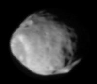
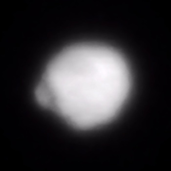
This is an image of Phobos made by Spirit during the sol 675 eclipse ingress sequence. I collected six 16 bit frames from the PDS, stretched the contrast, enlarged each frame x3, sharpened it, stretched the contrast more for the part wholly on the disk, and combined them - in effect the super-resolution process. I don't recall seeing Stickney so clearly before from the surface. Phil 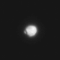
-------------------- ... because the Solar System ain't gonna map itself.
Also to be found posting similar content on https://mastodon.social/@PhilStooke Maps for download (free PD: https://upload.wikimedia.org/wikipedia/comm...Cartography.pdf NOTE: everything created by me which I post on UMSF is considered to be in the public domain (NOT CC, public domain) |
|
|
|
|
Jun 24 2013, 10:47 PM
Post
#54
|
|
|
Senior Member Group: Admin Posts: 4763 Joined: 15-March 05 From: Glendale, AZ Member No.: 197 |
Amazing Phil. Never would have thought you could do this with MER photos.
-------------------- If Occam had heard my theory, things would be very different now.
|
|
|
|
|
Jun 25 2013, 03:58 AM
Post
#55
|
|
|
Member Group: Members Posts: 808 Joined: 10-October 06 From: Maynard Mass USA Member No.: 1241 |
Phil, that is incredible!, thanks
-------------------- CLA CLL
|
|
|
|
|
Jun 25 2013, 06:19 PM
Post
#56
|
|
|
Senior Member Group: Members Posts: 1088 Joined: 19-February 05 From: Close to Meudon Observatory in France Member No.: 172 |
QUOTE (Phil Stooke @ Jun 24 2013, 09:40 PM) .../... I don't recall seeing Stickney so clearly before from the surface. Phil WOW ! WOW ! WOW ! Phil you did a great "premiere" (as usual). Lots of congratulations ! Thanks a lot for sharing this fantastic image with us. Now, just imagine what we could do with the Mastcam 100...
|
|
|
|
|
Jun 25 2013, 11:33 PM
Post
#57
|
|
|
Member Group: Admin Posts: 976 Joined: 29-September 06 From: Pasadena, CA - USA Member No.: 1200 |
wow, just wow. I can't imagine what Phil would do as a rover driver!
Paolo -------------------- Disclaimer: all opinions, ideas and information included here are my own,and should not be intended to represent opinion or policy of my employer.
|
|
|
|
|
Jun 26 2013, 12:01 AM
Post
#58
|
|
|
Founder Group: Chairman Posts: 14432 Joined: 8-February 04 Member No.: 1 |
I have concerns over what he might attempt with respect to +Z motion
|
|
|
|
|
Jun 26 2013, 12:03 AM
Post
#59
|
|
 Member Group: Members Posts: 754 Joined: 9-February 07 Member No.: 1700 |
Gorgeous, Phil - it needs to be on the cover of a Mars novel
|
|
|
|
|
Jun 26 2013, 12:04 AM
Post
#60
|
|
|
Solar System Cartographer Group: Members Posts: 10164 Joined: 5-April 05 From: Canada Member No.: 227 |
You write it, I'll provide the cover art!
Phil -------------------- ... because the Solar System ain't gonna map itself.
Also to be found posting similar content on https://mastodon.social/@PhilStooke Maps for download (free PD: https://upload.wikimedia.org/wikipedia/comm...Cartography.pdf NOTE: everything created by me which I post on UMSF is considered to be in the public domain (NOT CC, public domain) |
|
|
|
|
Jun 27 2013, 05:13 AM
Post
#61
|
|
|
Member Group: Members Posts: 890 Joined: 18-November 08 Member No.: 4489 |
A synthetically bumped up copy of Phobos
|
|
|
|
|
Jun 27 2013, 08:16 AM
Post
#62
|
|
|
Senior Member Group: Members Posts: 2998 Joined: 30-October 04 Member No.: 105 |
More and more detail!! I tried to find "a similar" image of Phobos taken by a Mars orbiter, but no luck. But I wonder if one could use Celestia (which I don't have) to generate a modeled view of Phobos from this perspective?
--Bill -------------------- |
|
|
|
|
Jun 27 2013, 03:33 PM
Post
#63
|
||
|
Solar System Cartographer Group: Members Posts: 10164 Joined: 5-April 05 From: Canada Member No.: 227 |
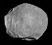
This is the same viewing angle but different lighting - it's MRO's CRISM observation of Phobos.
Phil
-------------------- ... because the Solar System ain't gonna map itself.
Also to be found posting similar content on https://mastodon.social/@PhilStooke Maps for download (free PD: https://upload.wikimedia.org/wikipedia/comm...Cartography.pdf NOTE: everything created by me which I post on UMSF is considered to be in the public domain (NOT CC, public domain) |
|
|
|
|
|
|
Jun 27 2013, 03:37 PM
Post
#64
|
|
 Senior Member Group: Members Posts: 1619 Joined: 12-February 06 From: Bergerac - FR Member No.: 678 |
This is just GREAT Phil, I love this kind of work
-------------------- |
|
|
|
|
Jun 27 2013, 04:21 PM
Post
#65
|
|
|
Solar System Cartographer Group: Members Posts: 10164 Joined: 5-April 05 From: Canada Member No.: 227 |
And I love your work!
Phil -------------------- ... because the Solar System ain't gonna map itself.
Also to be found posting similar content on https://mastodon.social/@PhilStooke Maps for download (free PD: https://upload.wikimedia.org/wikipedia/comm...Cartography.pdf NOTE: everything created by me which I post on UMSF is considered to be in the public domain (NOT CC, public domain) |
|
|
|
|
Jun 27 2013, 05:06 PM
Post
#66
|
|
|
Member Group: Admin Posts: 976 Joined: 29-September 06 From: Pasadena, CA - USA Member No.: 1200 |
QUOTE (Phil Stooke @ Jun 27 2013, 07:33 AM) This is the same viewing angle but different lighting - it's MRO's CRISM observation of Phobos. ... Wow, just wow. I wonder if HiRISE was ever pointed at anything that was not Mars, and if so, what was imaged. Paolo -------------------- Disclaimer: all opinions, ideas and information included here are my own,and should not be intended to represent opinion or policy of my employer.
|
|
|
|
|
Jun 27 2013, 05:09 PM
Post
#67
|
|
|
Senior Member Group: Members Posts: 2998 Joined: 30-October 04 Member No.: 105 |
That is what I ran into-- "same viewing angle but different lighting" in many cases. The viewing angle is fairly fixed-- being the "middle of the subarean hemisphere" (within bounds of nutation), with the lighting being the variable...
--Bill -------------------- |
|
|
|
|
Jun 27 2013, 06:00 PM
Post
#68
|
|
|
Solar System Cartographer Group: Members Posts: 10164 Joined: 5-April 05 From: Canada Member No.: 227 |
"I wonder if HiRISE was ever pointed at anything that was not Mars"
Paolo, there are spectacular images of Phobos and Deimos from HiRISE. Phil http://hirise.lpl.arizona.edu/phobos.php http://hirise.lpl.arizona.edu/deimos.php -------------------- ... because the Solar System ain't gonna map itself.
Also to be found posting similar content on https://mastodon.social/@PhilStooke Maps for download (free PD: https://upload.wikimedia.org/wikipedia/comm...Cartography.pdf NOTE: everything created by me which I post on UMSF is considered to be in the public domain (NOT CC, public domain) |
|
|
|
|
Jun 27 2013, 06:09 PM
Post
#69
|
||
|
Solar System Cartographer Group: Members Posts: 10164 Joined: 5-April 05 From: Canada Member No.: 227 |
And - this is Mars Express - it's from a sequence showing Phobos and Deimos in the same frame, not quite the same view but close, with opposite lighting.
http://www.planetary.org/blogs/emily-lakda.../2009/2250.html Phil
-------------------- ... because the Solar System ain't gonna map itself.
Also to be found posting similar content on https://mastodon.social/@PhilStooke Maps for download (free PD: https://upload.wikimedia.org/wikipedia/comm...Cartography.pdf NOTE: everything created by me which I post on UMSF is considered to be in the public domain (NOT CC, public domain) |
|
|
|
|
|
|
Jul 5 2013, 12:14 PM
Post
#70
|
|
|
Senior Member Group: Members Posts: 1619 Joined: 12-February 06 From: Bergerac - FR Member No.: 678 |
About PDS imagery, I think I forget to show you this late afternoon Navcam panorama taken at Sol 1984. I've made this about 1 year ago.
-------------------- |
|
|
|
|
Jul 5 2013, 01:25 PM
Post
#71
|
|
|
Solar System Cartographer Group: Members Posts: 10164 Joined: 5-April 05 From: Canada Member No.: 227 |
Spectacular! I love those oblique lighting images.
Phil -------------------- ... because the Solar System ain't gonna map itself.
Also to be found posting similar content on https://mastodon.social/@PhilStooke Maps for download (free PD: https://upload.wikimedia.org/wikipedia/comm...Cartography.pdf NOTE: everything created by me which I post on UMSF is considered to be in the public domain (NOT CC, public domain) |
|
|
|
|
Jul 14 2013, 08:54 PM
Post
#72
|
||
|
Senior Member Group: Members Posts: 1088 Joined: 19-February 05 From: Close to Meudon Observatory in France Member No.: 172 |
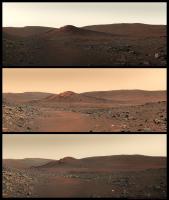
QUOTE (Ant103 @ Jul 5 2013, 02:14 PM) About PDS imagery, I think I forget to show you this late afternoon Navcam panorama taken at Sol 1984. I've made this about 1 year ago. Congratulations Ant103 ! Beautiful work indeed  Yes : images taken with loooong shadows are always very beautiful... As a reminder, here is the triplet I made end of 2010, carefully extracting colors from the images from the Calypso pan and merging them with the images taken on Sols 2001 to 2003.
Explanations are found at : http://www.unmannedspaceflight.com/index.p...st&p=169422 Enjoy also
|
|
|
|
|
|
|

|
Lo-Fi Version | Time is now: 22nd May 2024 - 04:39 PM |
|
RULES AND GUIDELINES Please read the Forum Rules and Guidelines before posting. IMAGE COPYRIGHT |
OPINIONS AND MODERATION Opinions expressed on UnmannedSpaceflight.com are those of the individual posters and do not necessarily reflect the opinions of UnmannedSpaceflight.com or The Planetary Society. The all-volunteer UnmannedSpaceflight.com moderation team is wholly independent of The Planetary Society. The Planetary Society has no influence over decisions made by the UnmannedSpaceflight.com moderators. |
SUPPORT THE FORUM Unmannedspaceflight.com is funded by the Planetary Society. Please consider supporting our work and many other projects by donating to the Society or becoming a member. |
|